We found 109198 price guide item(s) matching your search
There are 109198 lots that match your search criteria. Subscribe now to get instant access to the full price guide service.
Click here to subscribe- List
- Grid
-
109198 item(s)/page


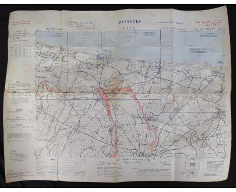
Lot 398
WW2 British May 1944 Map of the D - Day Normandy Beaches Marked Defences Ryes. Sheet 37/18 SW. Issued example with some pencilled markings, including Omaha and Gold Beaches. Size 71cm x 54cm. Marked Secret and Top Secret. This is the landing area and part of the D+ Advance area of British 50th TT Infantry Division with attached 8th Armoured Brigade , western part of British 2nd Army linking to the west with the US 1st Inf Div "The Big Red One" landing on the eastern part of Omaha. , 50th Div was the most combat experienced unit to land on D Day .


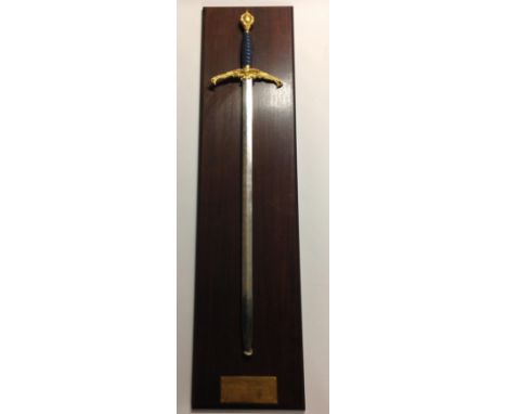
Lot 443
Wilkinson Sword Commemorative Limited Edition ""Price of Freedom Sword"". Produced in 1995 to commemorate the 50th Anniversary of VE Day. No 314 marked to blade. 85cm long double edged blade which has etched decoration to both sides inlaid with gold finish. Broad 23cm wide crossguard with Dove of Peace design. Pale blue leather wire bound grip. Gilt pommel with map of world design. Overall length 110cm. These swords were not produced with scabbards but instead come with a wooden display mount for wall hanging which is complete with a brass plaque with a quotation from Churchill ""The Price of Peace is Eternal Vigilance"".


Lot 459
GREY, Earl - ALs addressed from number 10 Downing Street, dated 29th Sept. 1831, discussing the Great Reform Bill:. With a collection of papers relating to Earl Grey, including an Elizabethan document dated 1573, also a large folded map of Georgian Bay of Lake Huron, dated 1928. With correspondence relating to Howich School. * (ten pieces)
Lot 485
BARNSTAPLE & BIDEFORD : ... A chart of the North East Coast of Devonshire between Hartland Point and Combe-Martin. Including the Bar and Ports of Barnstaple and Bideford, the Harbour of Ilfracombe and Lundy Island, Surveyed in 1832, by Lieut. H. M. Denham, R. N ... Extracted from the Survey of the Bristol Channel ... [etc]. Large scale uncoloured folding map dissecting into 24 parts, mounted on linen, scale one inch to one mile, size 1860 x 960mm, very good condition no slipcase,1833. * Rare

Lot 496
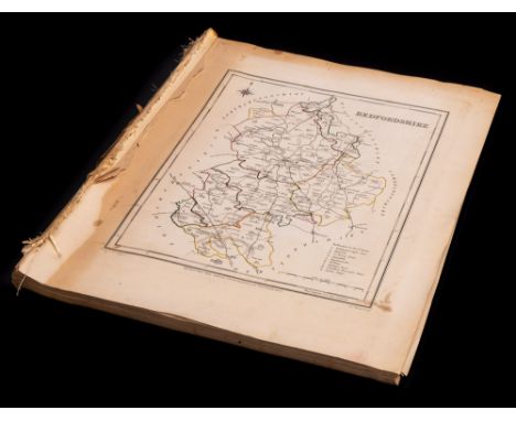
CARTO-BIBLIOGRAPHY : Chubb, Thomas, The Printed Maps in the Atlases of Great Britain and Ireland. A Bibliography, 1579-1870.Original cloth, stout 4to, Homeland Association, 1927. With - Tooley's, Dictionary of Mapmakers, cloth in d/w, 4to, signed by the compiler on the half-title, Map Collector, n.d. With other books relating to antique maps.(box)


Lot 510
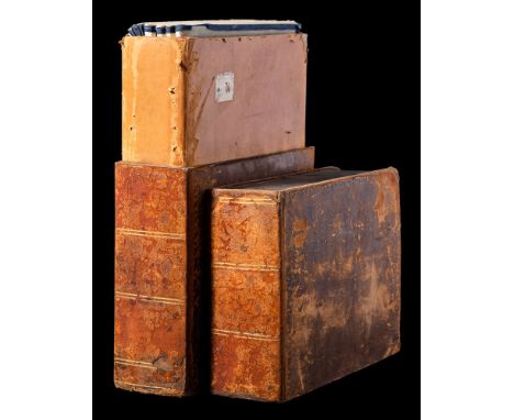
GREENWOOD, C & J/ Pringle, George - Map of the County of Somerset, from an actual survey made in the years 1820 & 1821:, large scale map with full wash hand colouring with a large vignette of Wells Cathedral, linen backed dissecting in to 72 parts. In a very worn original book box, map in very good condition with beautiful strong original hand colouring., 1822.
![LEWIS, S (publisher) - A Map of England and Wales Divided into Counties, Parliamentary Divisions & Dioceses: ... [etc] 3 ex.](https://cdn.globalauctionplatform.com/ec2745ea-c74b-4e74-beba-ac6800e10709/5eca25f1-0d48-4bd2-ab22-ac690105d944/468x382.jpg)
Lot 519
LEWIS, S (publisher) - A Map of England and Wales Divided into Counties, Parliamentary Divisions & Dioceses: ... [etc] 3 ex. 4 parts. WITH - Dugdale, Thomas, Curiosities of Great Britain. England and Wales Delineated, 9 odd volumes which included county maps. WITH - Lewis, S .. (publisher) An Atlas, comprising Maps of the Several Counties, gen. map (Used), 39 full-page maps, 1842. * sold with all faults not subject to return


Lot 527
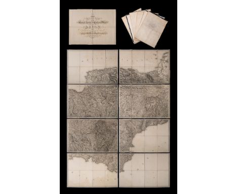
ORDNANCE SURVEY : The second part of the general survey of England and Wales. Containing the whole of DEVON and a proportion of the adjoining counties - large uncoloured map in eight parts folding in to 36 sections mounted on linen, slight water stain to lower part of the map, not offensive, no slipcase,1809. With the supplementary title sheet folding in 4 sections.


Lot 543
SPEED, John - Wiltshire : hand coloured map, published by John Sudbury & John Humble, size 505 x 475mm, pronounced staining to centre fold. 'old' Hogarth frame and double-glazed to show English text on verso, c1610. With Pieter van den Keere, Leicestershire, hand coloured map, size 120 x 85mm, c1617 (or later, but seventeenth century).(2)

Lot 163
BIBLE: The Bible That is. The Holy Scriptures contained in the Old & New Testament; cont. calf very rubbed boards detached, folio, New Testament dated 1611. Eng. title-page, eng. 'tree of plenty' plate, wood block map in text, folio, contents have broken in the spine and there are some loose pages, there may be something lacking at the beginning of the 'Apocrypha', contents are mainly clean, sellotape repair to one page,separate title-pages for the New Testament, the second table has the date 1612.*Notes An interesting 'Breeches' Bible with two pages of seventeenth century ownership inscriptions, the earliest dated 1634, Fra. Butler. Genesis 111, verse 7, (they sewed fig tree leaves together)* sold with all faults not subject to return

Lot 266
BALL, Charles - The History of the Indian Mutiny : giving a detailed account of the Sepoy Insurrection in India, (etc), 7 vols, double-page map, steel engraved plates with some staining and spotting mainly confined to the margins, org. cloth damp faded stained, 4to, London Printing & Publishing Co, c1850s.

Lot 273
CHURCHILL, Winston Spencer - London to Ladysmith via Pretoria : maps and plans inc. large folding frontispiece map, org. pictorial cloth a little soiled, 8vo, Longmans, Green, new impression, 1900. With - Great Contemporaries, org. cloth in torn d/w, 8vo, reprint, 1937. With - My Early Life, finely rebound in half morocco, 8vo, reprint, 1930. With 2 others relating to Churchill.(5)

-
109198 item(s)/page