We found 109182 price guide item(s) matching your search
There are 109182 lots that match your search criteria. Subscribe now to get instant access to the full price guide service.
Click here to subscribe- List
- Grid
-
109182 item(s)/page


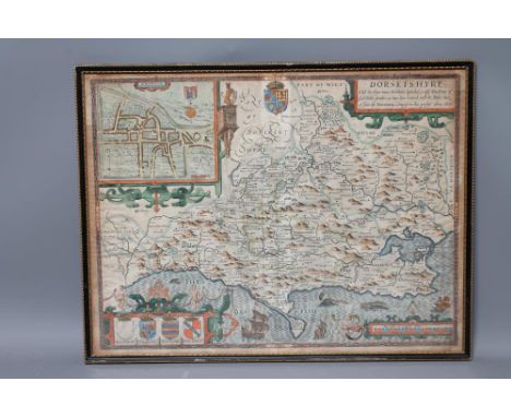
Lot 526
JOHN SPEED AND JODOCUS I HONDIUS (16th/17th Century), "Dorsetshyre ... 1610", engraved hand coloured map from John Speed's "Theatre of the Empire of Britain", with title cartouche, plan of Dorchester, scale and armorials, plate size 15" x 19 3/4", Hogarth frame (Est. plus 21% premium inc. VAT)

Lot 504
JOHN SPEED (Bassett & Chiswell edition), 17th century, The North and East Riding of Yorkshire, 1676, hand coloured engraved map with title cartouche, plans of Richmond and Hull, scale cartouche and Arms of Earls of Holderness and Richmond, text to reverse, 17" x 21 1/2, Hogarth frame (Est. plus 21% premium inc. VAT)


Lot 527
JOHN SPEED (1552-1629), "The West Riding of Yorkshire ... 1610", hand coloured engraved map with title cartouche, plan of York, the Arms of the Dukes of York and figural scale, plate size 15" x 20 1/4", together with another "Yorkshire" by Thomas Conder (1747-1831), c.1780, 7 1/2" x 10 1/2", Hogarth frames (2) (Est. plus 21% premium inc. VAT)


Lot 529
JOHN CARY (1754-1835), The East Riding of Yorkshire, 1793, engraved, hand coloured map, plate size 8 1/2" x 10 1/2", card mount, unframed, together with three other small unframed maps of Yorkshire, Baker's Part of the West Riding, R. Phillips 1808 Yorkshire, and Walpole's New Map of Yorkshire (4) (Est. plus 21% premium inc. VAT)


Lot 515
GERARD VALK AND P. SCHENK (17th/18th Century), The West Riding of Yorkshire, 1705 (Reissue of Jansson), hand coloured engraved map with figural title cartouche, figural scale and armorials, published in "Atlas Anglais" 1714, plate size 16 1/4" x 19 1/2", card mount, unframed (Est. plus 21% premium inc. VAT)

Lot 521
EMANUEL BOWEN (1693-1767), Norfolk, hand coloured engraved map with figural title cartouche, dedication to the Earl of Buckingham, compass rose and scale, 20 1/2" x 27 3/4", Hogarth frame, together with another similar by John Cary 1807, 19 1/2" x 21", framed (2) (Est. plus 21% premium inc. VAT)


Lot 9
THE KENNEDY OF CASSILLIS FRENCH AND INDIAN WAR ENGRAVED MAP POWDER HORN 18TH CENTURY with later white metal mounts engraved DATE/ Sept. 5th 1760, the butt cover engraved with the heraldic crest for Kennedy of Cassillis; the horn displaying the British Royal Arms above a trophy and banner NEW YORK and a view of the skyline, the body of the horn engraved with a map of the Hudson and Mohawk Rivers, terminating at Lake Champlain and Lake Ontario, marked with the principal cities, towns, and forts, and a cartouche marked 'JOHN COU/LTER HIS/ HORN MA/ DE BY SA/ M DAVIS'(26cm long)


Lot 527
Gueret “Proclamation sur la loi relative a l'Emprint d'Angleterre” (6-1-1798?), Framed, 27x22 (frame size) & H. Jaillot - Le Diocese de Tournay, Paris 1695, Original map, Framed, 27x24 (frame size) & N. Sanson - Partie Meridionale de l'Eveche de Chartres (c. 1780), Original map, Framed, 24x29 (frame size) (3)


Lot 375
VANCOUVER, Charles - A General View of the Agriculture of the County of Devon : folding map, 28 plates, 7 tables, binder's cloth, 8vo, 1808. With - Risdon, Tristram, The Chorographical Description or Survey of the County of Devon, half calf, 8vo, 1811. With - Worth, R. N, History of Plymouth, illust, org. morocco, stout 8vo, 1890. With one other.(4)


Lot 281
ROMER, Majors C.F & Mainwaring, A.E - The Second Battalion Royal Dublin Fusiliers in the South African War : illust, large folding map of Aden has been loosely inserted, org. cloth, 8vo, 1908. With Morton, J. W, 8th (King's Royal Irish) Hussars, illus, org. cloth, 8vo, (used copy) 1905. With one other, and a plastic envelope containing 'Souvenir from South Africa."(4)


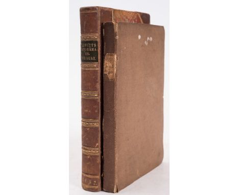
Lot 298
BLEWITT, Octavian - The Panorama of Torquay, a descriptive and historical sketch of the district comprising between the Dart and Teign : illust. inc. hand coloured map, cont. half calf, 8vo, Cockrem, Torquay, 1832. With - Croydon, Edward (pub), The Torquay Guide, folding map, org. cloth worn, 8vo, Torquay, 1841.(2)


-
109182 item(s)/page