We found 118276 price guide item(s) matching your search
There are 118276 lots that match your search criteria. Subscribe now to get instant access to the full price guide service.
Click here to subscribe- List
- Grid
-
118276 item(s)/page


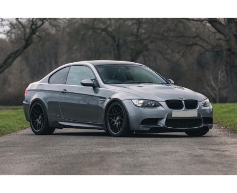
Lot 266
A carefully developed E92 M3 that has been engineered to offer the ultimate Track Day/Fast Road balance.A standard E92 M3 was selected and taken to Race Performance in LincolnVendor has strong links in Motorsport world. This car used as a test bed for Alcon BrakesImpressive spec with over 200 man hours and serious investment, 440 bhp at wheelsNew big end bearings, Willie Poole roll-cage, Alcon RC6 front, Alcon RC4 rear brakesBilstein coil-over kit. 19” genuine CSL wheels. Akrapovič exhaust system and much more52,154 miles, this special and versatile BMW could not be replicated anywhere near this guide priceImmense fun, being capable of embarrassing many ‘supercars’ out there on the track-day sceneThis 2009 BMW M3 (E92) has been engineered to be the ‘Ultimate Track Day Missile’. A ‘standard’ E92 M3 was selected and taken to well respected specialists, Race Performance Ltd., who are based in Lincoln. Our vendor has strong links throughout the Motorsport world and consequently this car has been offered as a ‘test-bed’ to assist in the ‘development’ of suspension parts and predominantly for brake development by Alcon Brakes, a company who specialise in ultra high-quality brakes and are the preferred brake manufacturer for many race team around the world, including Le Mans-winning, Aston Martin RacingThe spec for this impressive car is listed below:Refreshed engine with the, all important, new big end bearings.Mapped – 440 bhp at the wheels. BMC induction kitAlcon R36 front brakes, Alcon R34 rear brakes (circa £5k worth)Bilstein Club-sport coil-over kit. Set up and race aligned.19” genuine CSL wheels. Willie Poole rear roll-cage. Corbeau seats and harnessAkrapovič exhaust system – Titanium & Iconel, carbon-fibre tips.GT4/GTS gearbox, DCT map. BMW Motorsport GT4 power steering and gearbox coolersRace Performance informs us that over 200 hours and some serious investment have gone into this particular car and, indeed, Alcon Brakes have been using it as a ‘demo’ car in recent years. Race Performance have also recently recommissioned the BMW following a period in storage and it’s now in possession of a fresh MOT.Having covered just 52,154 miles, this special and versatile BMW could not be replicated anywhere near this guide price. It’s immense fun, being capable of embarrassing many ‘supercars’ out there on the track-day scene or, with a bit more investment and preparation (full roll cage, safety equipment etc) could be turned into a circuit racer with serious potential. Representing extremely good value for money, in our opinion, and with the versatility of driving it on the road to the track, really makes it an appealing proposition. SpecificationMake: BMWModel: E92 M3Year: 2009Chassis Number: WBSWD92040PY38032Engine Number: 20094356Make: Click here for more details and images
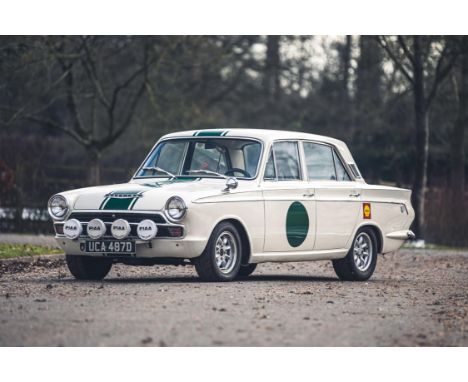
Lot 418
Fully restored in 2002 and recently refreshed this is a delightful example of a rare model.Sold directly to Switzerland in 1966 returning to the UK in 2016Nut and bolt restoration in France by Cedric Masier around 2002Lotus Cortina aluminium 4-speed, close-ratio box with Quaife internalsLotus Cortina struts and dampers optimised for fast road use, Brembo discs, Girling pistons and Pagid fast-road padsGT pre-X-Flow with a big valve head, blueprinted, lightened and balanced with a Kent 244 cam fuelled by twin 45 Webers. Originally built by Burton RacingFull engine strip, inspection, and rebuild including a new Kent 244 cam and followers by Coltec (22-12-2014 - £1,606)Period-style bucket seats, Moto-Lita, Brantz International Pro-2 Digital rally clock, Terratrip intercom with headsetsMassive history file (workshop manuals, vehicle manuals, technical articles)Prepared for road rallies, stage rallies, regularity runs or just chasing other Cortinas about on an Owner’s Club day out, this could be an ideal entry into the gently competitive word of classic rallying.Ford’s Cortina was a mid-sized family car launched in 1963, designed to fill a gap between the smaller Anglia and executive Zephyr/Zodiac models. With its lightweight shell and decent handling, Ford’s engineers soon realised that the Cortina had genuine potential as a performance model and thus created the GT, by adding a Cosworth-tuned 1.5-litre version of the Kent four-cylinder engine, upgrading the transmission, brakes and suspension, installing a rev-counter to the steering column and extra dials in the centre console. The Cortina GT was soon selling in huge numbers as few cars could match its 95mph top speed or willing acceleration, at such an affordable price. Cortina GTs were homologated by Ford for rallying and notched up numerous wins in the mid-1960s, while the more potent Lotus version was developed for circuit racing.This delightful 1966 Cortina GT is a four-door example, finished in left-hand drive and exported to Switzerland where it has spent most of its life. It returned to the UK in 2016 and the registration number, UCA 487D was awarded by the DVLA in September of that year.There is a significant amount of history with UCA and naturally, most of that is in French or German, but we can see from the invoices that the car has been subject to a total nut and bolt restoration in France by Cedric Masier and Patrick Hugo around 2002 utilising “Genuine Ford Motorsport Period Upgrades”. It was rebuilt with a Lotus Cortina aluminium 4-speed, close-ratio box with Quaife internals (1-2.5, 2-1.66, 3-1.22, 4-1.1. Limited slip differential 3.9-1). It’s been set up with Lotus Cortina struts and dampers optimised for fast road use, Brembo discs, Girling pistons and Pagid fast-road pads.The engine is a GT pre-X-Flow with a big valve head, blueprinted, lightened and balanced with a Kent 244 cam fuelled by twin 45 Webers. Originally built by Burton Racing, there is an invoice in the file from Coltec Racing dated 22-12-2014 totalling £1,606 relating to a full engine strip, inspection, and rebuild including a new Kent 244 cam and followers and a repaint of the block in Holbay Green. It’s fitted with a competition clutch and a Race Stainless Steel exhaust (since changed).The interior was renewed back in 2012 and remains very smart with twin period-style bucket seats, Moto-Lita steering wheel, Brantz International Pro-2 Digital rally clock with remote, map light and Terratrip intercom with headsets. The GT continues to present really well in Ermine White with a distinctive Forest Green triple stripe and door roundels and the coachwork appears exceptionally straight remaining very tidy underneath. This is a good-looking period Rally Car and it’s classic appearance is enhanced by the silver alloys, Speedwell wing mirrors and four PIAA rally-spec front lights. We understand that the car has been enjoyed in light competition throughout Europe and even on the hugely challenging Monte Carlo Rallye and the Winter Raid it proved totally reliable.UCA was purchased by our vendor on 2/03/2019 and he informs us that during his ownership “I changed the silencer to make it less loud, changed the crown wheel and pinion from the 4.7 to a more roadworthy 3,9, fitted a new lightweight starter motor, renewed the interior carpet and soundproofing, changed the wheel studs so that it could take the Minilite wheels, fitted 5 new Revolution Minilites with new Toyo tyres, renewed the steering idler arm and associated bushes, and finally took it to a specialist to balance the twin Weber carbs.”Included in the large history files are technical articles, workshop manuals, vehicle manuals, the original ‘Carnet de Service’, magazine articles featuring this motor car, acres of invoices, the UK V5 registration document and much more. It's also supplied with six original steel rims with snow tyres.This not a weary, rally-rashed, Forest Ford but a delightfully presented Sixties sporting saloon that appears to have been cared for during its fifty years in Switzerland and certainly since it returned here in 2016. Only 59 Mk1 GTs are believed to be still current in the UK, and very few will be left-hand drive with four-doors, so this is a rare car in its own right. Prepared for road rallies, stage rallies, regularity runs or just chasing other Cortinas about on an Owner’s Club day out, this could be an ideal entry into the gently competitive word of classic rallying.SpecificationMake: FORDModel: CORTINAYear: 1966Chassis Number: BA78FU70443Transmission: ManualEngine Number: 120E-6015Make: Interior Colour: BlackClick here for more details and images
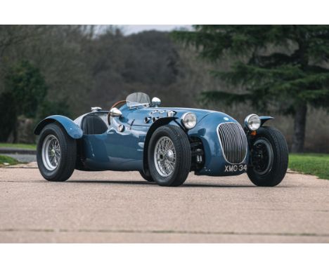
Lot 205
An important part of, not only Motorsport History, but British Post-War Social History.John Heath and George Abecassis evolved a modified version of their successful 1949 HW-Alta design for the 1950 seasonA prototype and four team cars were to have been built, Team drivers were to be Abecassis, Heath and Stirling MossIn the event, only 3 cars and a prototype were built, FB IOI, 102, 103 and 104Built officially by HW Motors they were known as 'HWM's, a name that is synonymous with Britain's first post-war steps into the world of Grand PrixOffered by Silverstone Auctions is the first of the four works cars that has an incredible race history in 1950 raced by Moss, John Heath, Lance Macklin, George Abecassis and Rudi Fischer In all, it raced in fifteen events across Europe including Reims, Grand Prix de Bern and Grand Premio De Bari In October 1950, Stirling gave it its swansong win at Castle Combe before being sold to Oscar Moore in 1951Now road registered, XMC 34, it was purchased by our vendor in 1965 and enjoyed a further lease of life usually driven by some fast ladies at Midland hill climb eventsThis is an important car and we suggest you read the full description on our websiteThe significance of HWM to British motor racing history has been widely overlooked yet John Heath’s foray into the European racing scene with his private team of three Formula Two HWMs in 1950 marked the first post-war attack on International racing by a full team of British cars and effectively put Britain back on the motor racing map. Despite a shoestring budget and daunting physical, financial and logistical problems, John Heath’s enterprising little Ecurie raced at nineteen British and Continental meetings during 1950 with creditable success. In so doing they brought immeasurable prestige to Britain across a Continent still recovering from the ravages of war. Perhaps even more important to Britain’s future prestige in motor racing, during that I950 season the perspicacious Heath and partner George Abecassis gave the first chance of big time motor racing to a confident twenty-year-old rising star. His name was Stirling Moss.For the 1949 season, Heath decided that the team should design and build a car of their own for Formula Two and sports car racing. This dual-purpose car used a 2-litre Alta engine in a twin-tube chassis with wishbone front suspension, a transverse leaf spring, Standard 12 uprights, a Citroen steering rack (HW Motors were Citroen dealers), an ENV pre-selector gearbox and a live rear axle. This HW-Alta proved a great success, with viceless handling and took Heath to victory in the 70-mile 1949 BRDC Race in the IoM and a close second to Possi’s Delahaye in the GP de l’ACF, run for sports cars, at Comminges.Encouraged by this success, Heath and Abecassis evolved a modified version of the HW-Alta design for the 1950 season as the nucleus of a three car team. The offer of an entry at Le Mans encouraged the adoption of the dual-purpose design (a rear-engined F2 car had been contemplated), but when it was discovered that only prize-money was on offer, the Sarthe entry was dropped and the cars ran as open-wheel single-seaters throughout 1950. Team drivers were to be Abecassis, Heath and Moss (Peter Clark, Nick Haines and Johnnie Claes were to have been second drivers at Le Mans). A prototype and four team cars were to have been built, the fourth to have been a spare. In the event, Heath, Alf Francis and their small team of Tom O’Hara and Rex Woodgate, with Jack Tolly as a part-time welder, built only four cars, including the prototype, though it seems that an additional chassis may have been laid down but not completed. They were given chassis and engine numbers FB IOI, 102, 103 and 104, FB being Geoffrey Taylor’s prefix for Formula B Alta engines, FB the forerunner of F2. The first three numbers related to the cars intended for the team and, perversely, the prototype seems to have been given the last number. Presumably it was built without a number and given 104 for carnet purposes after the others had been allocated. It had been intended to sell the prototype to Baring, a locally based privateer. In fact Baring bought the brand-new 103 and the prototype was taken on to the team strength with 101 and 102. These new machines from HW Motors were given the name “HWM”.With confidence high and a great design, they famously gave breaks to young drivers of potential with the late Sir Stirling Moss being effectively offered his first works drive debuting at Goodwood at the Easter Meeting in April finishing 2nd in the Easter Handicap.Offered by Silverstone Auctions is the first of the four works cars that has an incredible race history in 1950 raced by Moss, John Heath, Lance Macklin, George Abecassis and Rudi Fischer. In all, it raced in fifteen events across Europe including Reims, Grand Prix de Bern and Grand Premio De Bari. In October 1950, Stirling gave it its swansong win at Castle Combe before being sold to Oscar Moore in 1951 who continued to race it with great success and even registered it for the road with the North London registration of XMC 34. It was purchased by our vendor in 1965 and enjoyed a further lease of life usually driven by some fast ladies at Midland hill climb events.Going back to 1950, only two cars were finished for the Easter Monday Goodwood event and HWM allowed privateer Alistair ‘Buster’ Baring to drive one to keep him sweet as he had the fourth built car earmarked for him. Stirling finished sixth in the Chichester Cup Formula Libre race and second in the Easter Handicap. A third car was ready for Roubaix in early May and Baring would get his own car a week later for Mons when finally all four works cars ran. They all had minor bodywork differences and the car offered here is 1950/A – the prototype. It was to be shared between George Abecassis (seven races) and John Heath (five races/ fourth place at Reims) Lance Macklin (four times, third at Mettet) and Sir Stirling Moss twice (first and third at Castle Combe). The result sheets show that, remarkably, the works HWMs were only second best to the likes of Alberto Ascari in the Ferrari and the works Alfas of Farina and Fangio.To help finance the 1951 season, the three works cars were sold off having been equipped with mudguards and lights to make them more saleable. In 1951 our car, last driven by Moss, was sold to privateer racer Oscar Moore of North London who registered it for the road and fitted a Jaguar 3.4 engine from an XK120 but enlarged to 3781 cc. He often liked to say he beat Coventry to it! This was the first HWM Jaguar and was very competitive from the outset capable of beating C-Types on twisty circuits. It was eventually sold to Plymouth motor trader, Gerry Scali, before turning up with London trader Danny Margulies who had handled the sale of the fabulous HWM Streamliner. It was purchased by our vendor, Terry Grainger, a well known Worcestershire architect and cricketer in 1965 and some fifty five years later he still owns it. At some point the bodywork had seen better days and Oldbury Wing and Panels Ltd. were tasked with carefully copying the original body. Over the past half century it has competed with great distinction at various hill-climbs driven by Georgina Baillie-Hill, Davina Galica and Gillian Goldsmith.This incredible piece of British motorsport history can trace its origins to those charismatic ‘Garagiste’ at HWM who took on 1950s Grand Prix legendsClick here for more details and images

Lot 248
Obverse: head of the king and duke facing left, within inscription “WILH: II NASS: BELG: REX.LUXEMB:M: DUX.”; the reverse, with specially-made dedication in raised lettering: “VIRO.ORNATISSIMO.J.N.HUBERTY. PRO. OBLATA. CHARTA. GEOG. M.DUCAT. LUCTLIBURG. REX. MAG.DUX. D. A. MDCCCXLVIII”; in a round, moulded, boxwood capsule; together, a personal letter signedby William II to Mr. Huberty, with his compliments for the donation of the new map of Luxembourg;more, a letter of the General Administration of the Grand Duchy of Luxembourg, stating that the Kingand Grand Duke pleased himself to present a specially struck gold medal to Mr. Huberty and to hiscolleague Mr. Huschling, bot authors of the new map of Luxembourg, presented to the Grand Duke;the whole, in a futher, later envelope, with interesting notes about the succession of properties ofthe hereby offered medal.An unique piece, in mint condition!I RR!


Lot 775
Quadrophenia, the making Of - Limited Boxset Edition book by Simon Wells. Hand Signed by Franc Roddam (Film Director) and Simon Wells. Boxset Limited Edition - 500 copies. New & Unread, opened only to take photo of the signatures. The Making of Quadrophenia is the definitive account of Britain's greatest youth movie, containing behind-the-scenes photographs and interviews from principal cast members, director Franc Roddam, producer Bill Curbishley, scriptwriter Martin Stellman and many others. This deluxe box-set edition - limited to 500 copies - is hand signed by both Franc Roddam and Simon Wells, and contains the following exclusive items: A specially designed, illustrated map of the movie locations in Brighton. A reproduction of an original Japanese promotional brochure. A print of an Adrian Boot photograph taken on set. A set of four postcards featuring rare international posters. A certificate of authenticity, this is VERY rare! Good condition. All autographs come with a Certificate of Authenticity. We combine postage on multiple winning lots and can ship worldwide. UK postage from £4.99, EU from £6.99, Rest of World from £8.99
Lot 50
ASSORTED SILVER MEDALS comprising The Drake Silver Medal Map in box, Tercentenary of the birth of John Harrison 1693-1993 Commemorative silver medal in box with Certificate of Authenticity, Spanish Armada 400th 1588-1988 Commemorative silver medal in box with Certificate, The B.C.S. Inigo Jones and Sir Christopher Wren silver proof medal in perspex case and 800 years of Mayoralty 1189-1989 Commemorative silver medal in box with Certificate (5) Condition Report: All appear in good overall condition with no obvious or major damage. Very minor surface wear.
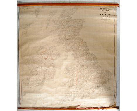
Lot 379
An original retro vintage 20th Century 1950's (1959) Edward Stanford Ltd large sized canvas wall hanging map of Great Britain. Sales Promotion Map No. 1 The British Isles published by George Philip & Son Ltd London. Map rolling for ease of transport with teak wood supports to each end. Measures approx 164 cm x 150cm.
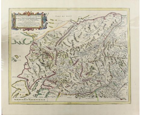
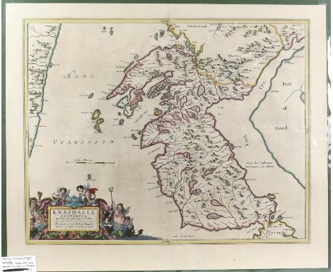
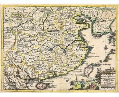
Lot 2202
Engraved map of Scotland, later coloured, c.1645, by Blaeu (Johannes & Pont Timothy), 'Scotiae Provinciae Mediterraneae inter Taum Flumen et Cararis Aestuarium: Sunt autem Braid-Allaban, Atholia, Marria Superior, Badenocha, Strath-Spea, Lochabria..., A description of the Inland Provinces of Scotland lying between Tay River and Murra Forth...', 42 x 53cmPROVENANCE: From the property of a deceased local collector.
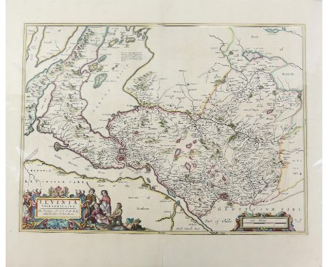
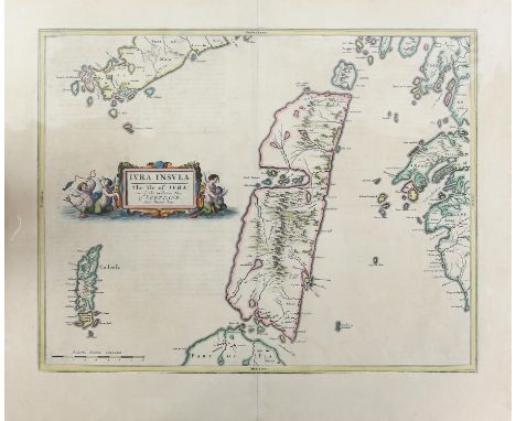
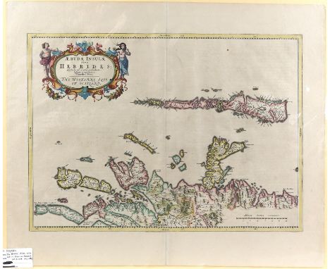
Lot 2203
J Blaue, map of 'Levinia, Vice Comitatus. The Province of Lennox called the Shyre of Dun-Britton', engraving, later hand-coloured, from the Bleau Atlas of Scotland 1654, 39 x 53cm, together with a map of The Isle of Islay from the Bleau Atlas of Scotland 1654, engraving, 40 x 52cm (2)PROVENANCE: From the property of a deceased local collector.
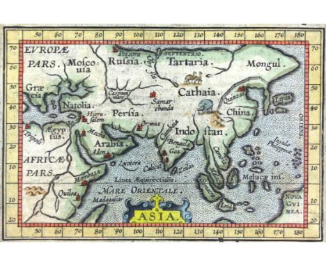
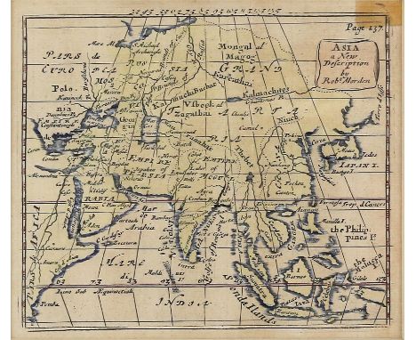
Lot 2214
17th century map of Asia in the manner of Abraham Ortelius (1527-98), 8 x 12 cms, hand-coloured coloured, with mount, Heirlooms label verso, probably published in 'Epitome Theatri Orbis Terrarum.' Abraham Ortelius, J. van Keerbergen. Antwerp, J.B. Vrients, 1609. Part of a private collection of maps
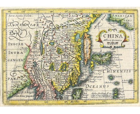
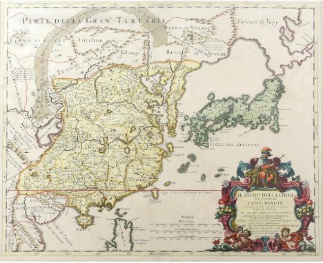
Lot 2218
17th century map of China and Japan by Giacomo Rossi, scrolled cartouche surmounted by The Great Khan, emperor of China, "il Regno Della China", 45 x 54 cms hand-coloured and with a mount, publ 1682 for Mercurio Geographico, Japan is shown with Northern Island Hokaido called Yupi joined to the mainland. Part of a private map collection.
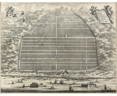
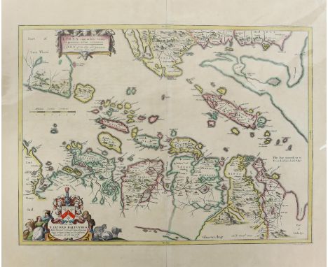
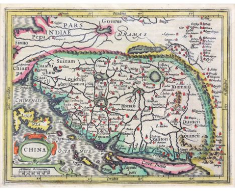
Lot 2220
Late 17th century map, Kantonis Plana Effigies depicting Guangzhou (Canton) and the surrounding countryside with ships and junks in the harbour, Putti hold the title and key cartouches. Among the sites identified are a mountain top pagoda, palaces, and a pair of castles in the water, 28 x 36 cms with a mount. Part of a private collection of maps

Lot 2222
Early 18th century map of Japan H. A Chatelarn Succession des Empereurs 37 x 45 cms From: Atlas Historique. Amsterdam, Châtelain, 1713-1719. Two panels depicting the death of a 15th century emperor and the arrival of a Dutch Embassy at Kyoto in the 17th Century, 37 x 45 cms, hand-coloured with gilt highlights and with a mount The atlas from which this comes was published in seven volumes between 1705 and 1720, with a second edition appearing in 1732. The maps were accompanied by information pertaining to cosmography, geography, history, chronology, genealogy, topography, heraldry, and costume of the world. The maps in the "Atlas Historique" were mainly based on those of the French cartographer, Guillaume De L'Isle, but were presented by Henri Abraham Chatelain. Label verso Man Fong Hong Kong. Part of a private collection of maps.
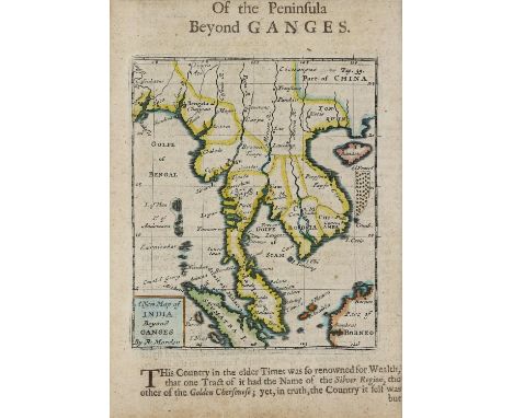
Lot 2224
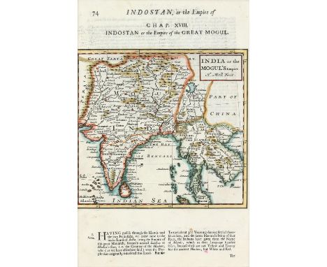
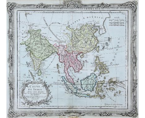
18th century Herman Moll map India and southwestern Asia, Indostan or the Empire of the Great Mogul, including modern Nepal, Bangladesh, Myanmar (Burma), Thailand, Cambodia, Laos, and Vietnam, published in "The Compleat Geographer: or, the Chorography and Topography of all the known Parts of the Earth" by Herman Moll, circa 1732. Includes towns and cities and topography. Printed on a page (74) that also includes text. and heading Chap XVIII, Map 17 x 18 cms hand-coloured with a mount part of a private map collection
Lot 2226
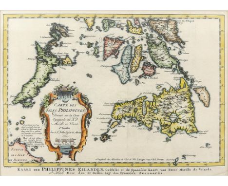
18th century map, Carte des Isles Philippines St Bellin engineer de la marine, 1752, 22 x 59 cms, coloured and with a mount, part of a private collection of maps,NOTES; Based upon Pedro Murillo Velarde map by the Mapmaker Nicolas Bellin 1752. Jacques Nicolas Bellin (1703 1772) He was born in Paris and was hydrographer of France's hydrographic office, member of the Académie de Marine and of the Royal Society of London. Over a 50 year career, he produced a large number of maps of particular interest to the Ministère de la Marine.
Lot 2229
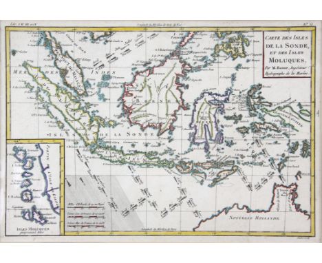
18th century map, Carte des Isles de la Sonde et des Isles Moluques by Bonne Rigobert (1729 1795); he was royal Hydrographer and his principle interest was in the production of marine charts. He also produced maps for atlases and encyclopaedias. This map covers Borneo and the surrounding islands and the top half of what is now Australia, there is an inset panel for Isles Moluques, Circa 1787, 24 x 34 cms Hand-coloured and with a mount, label Altfield Gallery Hong Kong.
Lot 2230
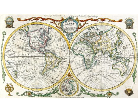
Early 19th century map, Bowen (Thomas) The World including the late Discoveries by Captain Cook and Other Circumnavigators, double hemisphere engraved map, title cartouche, four engraved navigational instruments to corners, 29 x 47 cms, c.1810 hand-coloured and with a mount . Part of a private collection of maps
-
118276 item(s)/page