We found 109182 price guide item(s) matching your search
There are 109182 lots that match your search criteria. Subscribe now to get instant access to the full price guide service.
Click here to subscribe- List
- Grid
-
109182 item(s)/page


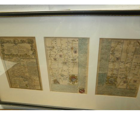
Lot 703
A collection of 19th and early 20th Century folded maps, some in sleeves, including Moggs 'New Map of England and Wales with part of Scotland', Cary's 'Reduction of his Large Map of England and Wales with part of Scotland', 'A New and Correct Map of The Lakes in the Counties of Cumberland, Westmorland & Lancaster', etc (11)


Lot 89
Butler (Frank Hedges). Through Lapland with Skis and Reindeer, with some account of ancient Lapland and the Murman Coast, 3rd impression, 1919, 65 black and white illustrations and 4 maps including folding map to rear, bookplate and period inscription to front endpapers, some light toning, original illustrated yellow cloth, 8vo, together with Pearl (Valerie), London and the Outbreak of the Puritan Revolution, city government and national politics, 1625-43, 1st edition, OUP, 1961, some light spotting, original blue cloth in price-clipped dust jacket, covers slightly toned, 8vo, plus Campbell (J.L. & Thomson, Derick), Edward Lhuyd in the Scottish Highlands 1699-1700, 1st edition, 1963, 24 black and white plates, original blue cloth in price-clipped dust jacket, covers spotted, 8vo, and other modern historical reference, including publications by Harvard, Batsford, Manchester University Press, all original cloth, many in dust jackets, G/VG, 8vo/folio (3 shelves)
Lot 169
Rufus (Quintus Curtius). Historiarum libri accuratissime editi, 1656, black and white engraved title, medallion portrait, folding map and plate to p. 75, some light marks and minor tears, contemporary vellum binding, 12mo, together with Bartlett (J), The Gentleman's Farriery, or, A Practical Treatise on the Diseases of Horses..., 5th edition, 1764, 4 black and white folding plates, plus frontispiece, period inscription and loss to front endpaper, some slight marks, contemporary full calf, spine slightly rubbed, 8vo, and Milton (John), Paradise Lost, A Poem in Twelve Books, printed for C. Hitch, et al, 1760, 12 black and white plates, plus portrait frontispiece, plus Paradise Regained, A Poem in Four Books, volumes 1 & 2, new edition, 1785, some light marks, all contemporary full calf, boards and spines slightly rubbed, 8vo, plus other 18th and 19th century literature and miscellaneous reference, all leather bindings, some odd volumes, condition generally good/very good, 8vo/12mo, approximately 50 volumes in total (a carton)
Lot 172
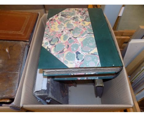
Marshall (William). The Rural Economy of Gloucestershire, including its Dairy, volumes 1 & 2, 1789, black and white folding map to volume 1, some light toning, uniform contemporary full calf, front boards detached, spines rubbed with some minor loss, 8vo, together with Smollett (T.), The Adventures of the Renowned Don Quixote de la Mancha, by Miguel de Cervantes Saavedra, volumes 1-4, 1803, black and white engraved frontispiece to each, period inscriptions to front endpapers and title pages, some minor spotting, uniform contemporary gilt decorated calf, boards and spines rubbed with some loss, volume 1 front board detached, 8vo, and Parson (H., printer), The Historical Part of the Holy Bible or The Old and New Testament, Exactly and Completely Describ'd in above Two Hundred Historical Cuts Curiously Engraven from Designs of ye best Masters, circa 1730, 201 black and white engravings plus title, period inscriptions to front endpapers, title page repaired, some light marks, and minor loss, rebound in later green full calf in red cloth presentation box, contains one of the original boards, 4to, plus other 18th and 19th century literature and miscellaneous reference, mostly leather bindings, condition is generally good/very good, 8vo/folio, 33 volumes in total (2 cartons)
Lot 102
Capper (John). The Three Presidencies of India: a history of the rise and progress of the British Indian possessions, 1853, numerous black and white illustrations plus folding map to front, some light spotting, original gilt-decorated red cloth, boards and spine faded and rubbed to head and foot, 8vo, together with Graham (Maria), Journal of a Residence in India, 2nd edition, 1813, 15 black and white plates, some light spotting, lacks original endpapers, rebound with modern brown boards, 4to, plus Jerrold (Douglas), The Story of a Feather, 1st edition, 1844, black and white illustrated frontispiece and half-title, some light toning, original gilt-decorated brown cloth in slipcase, spine faded, 8vo, plus other 19th-century literature and miscellaneous reference, all original cloth, many decorative, 8vo/4to, approximately 65 volumes in total (3 shelves)
Lot 45
Maw (W.H. & Dredge, J.). Engineering: An Illustrated Weekly Journal, volumes 23 (Jan.-Jun. 1877) & 35 (Jan.-Jun. 1883), numerous black and white illustrations including folding diagrams, some light marks and spotting, later half cloth bindings, boards and spines rubbed, folio, together with Gordon (Edward, editor), The Page, A Specimen Copy, 1899, approximately 16 black and white wood-engravings, some light spotting and offsetting, original illustrated front wrapper detached, spine deteriorated, lacking rear wrapper, 8vo, plus Buck (Edward J.), Simla, Past and Present, Calcutta, 1904, 51 black and white plates including folding map frontispiece, some minor marks, original decorative yellow cloth, boards and spine toned with minor loss to head and foot, 4to, plus other late 19th and early 20th-century illustrated literature and miscellaneous reference, including The Savoy, An Illustrated Quarterly, 8 volumes, a broken run, Jan.-Dec. 1896, Gazette Du Bon Ton, Art-Modes & Frivolites, 6 volumes, a broken run, Jan.-May, July 1914, some original cloth, condition is generally good, 8vo/folio (3 shelves)
Lot 149
Heylyn (Peter). Cosmographic in Foure Books Contayning the Chorographie & Historie of the Whole World..., 1669, one black and white folding map, plus 3 black and white facsimile replacement maps, lacks endpapers, half title and title pages restored, some marks and minor loss, modern brown cloth binding, folio, together with Bennet (Thomas, printer), Athenae Oxonienses. An Exact History of all the Writers and Bishops... of Oxford..., first volume, 1691, front endpaper and title detached, some light toning and spotting, contemporary brown half calf, front board partially detached, boards and spine ruubed, folio, and Norie (J.W.), A Complete Epitome of Practical Navigation..., 12th edition, 1840, black and white plates and maps, including frontispiece, contemporary inscription to front pastedown, some light marks, contemporary gilt decorated brown calf, front board partially detached, slightly rubbed, 8vo, plus other 18th and 19th century literature and reference, mixed leather and cloth bindings, condition is generally good, 8vo/folio (17)


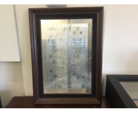
Lot 194
After John Walker 'Newly constructed and extended Map of India' dedicated to Major General Sir John Malcolm, G.C.B., published by Kingsbury, Parbury, & Allen Jan 11th 1825 in four linen-backed hand coloured sections with blue tape edge, subsidiary Map of Birman Empire (compiled chiefly from native information) each section 81cm x 65cm,
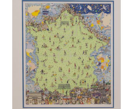
Lot 478
DESCRIPTION: A collage on paper by American artist titled:"The World Will Be Watching". Done as an ode to the 1998 World Cup which took place in France; features vibrantly hued figures and soccer players encompassing the soccer field that is designed as the outline of the map of France. Signed on bottom: "James Rizzi 'The World Will Be Watching' XXIII/C 1998"CIRCA: 20th Ct.ORIGIN: USAProvenance: Private Collection.DIMENSIONS:With Frame: H:37.5" L:31.25" Without Frame: H:27" L:22.25"CONDITION: Great condition. See lot description for details on item condition. More detailed condition requests can be obtained via email (info@akibaantiques.com) or SMS (305) 333-4134. Any condition statement given, as a courtesy to a client, is only an opinion and should not be treated as a statement of fact. Akiba Antiques shall have no responsibility for any error or omission.
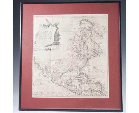
Lot 499
DESCRIPTION: Antique map titled: America das Mitternachtige nach der Zeichnung des Herren Wilhem Delisle". Features the Southwest, east, and Eastern coast of North America, as well as Central America and the very North of South America as well as the Carribbean. Intricately detailed and was made in 1745 and made by Johann Justine GebauersCIRCA: 18th Ct.ORIGIN: GermanyDIMENSIONS:Without Frame: H:17.25" L:16" Without Frame: H:13.25" L:11.75"CONDITION: Good condition .See lot description for details on item condition. More detailed condition requests can be obtained via email (info@akibaantiques.com) or SMS (305) 333-4134. Any condition statement given, as a courtesy to a client, is only an opinion and should not be treated as a statement of fact. Akiba Antiques shall have no responsibility for any error or omission.


Lot 211
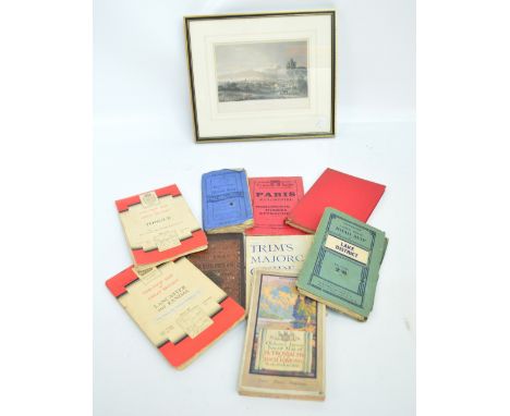
A SMALL COLLECTION OF ANTIQUARIAN BOOKS OF EUROPEAN INTEREST to include Alexander Adam - 'A Summary of Geography and History....', 6th edition 1824, 'The European Magazine' 1783 A/F but includes map of Naples & Sicily by Cary and view of Dublin, Lady Morgan - 'France in 1829-30' Vol. I, Rev. Isaac Taylor - 'Scenes in Europe for the amusement and instruction of little tarry-at-home travellers, 1821, 'Tales of a Grandfather'1831 3 vols, etc (9) Condition Report: Please note: every page of every book is not checked, if you are unable to view yourself please ask for detailed information
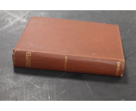
Lot 86
ROBERT LOUIS STEVENSON - 'KIDNAPPED', Cassell & Company, 1886, first edition, second issue, corrected text to pages 40, 64 and 101 and adverts at rear dated 07.86. No dustjacket, brown cloth boards.Condition Report:Slight wear on spine edgesFoxing to initial pages, map and end pages Inscription dated 11. 8. 1886

Lot 194
FREDERICK HASSELQUIST - 'VOYAGES AND TRAVELS IN THE LEVANT; in the years 1749, 50, 51, 52...', Charles Linnaeus, 1766Condition Report:ReboundStaining to folding map frontispiece and title page Please note: every page of every book is not checked, if you are unable to view yourself please ask for detailed information
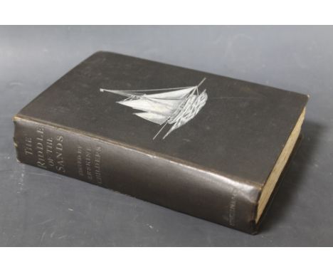
Lot 89
ERSKINE CHILDERS - 'THE RIDDLE OF THE SANDS, A Record of Secret Service Recently Achieved', Smith, Elder & co. 1903, first edition. No dustjacket, black cloth boards with white print. An important work considered to be the first spy novel.Condition Report:Split in cloth on spine edge, wear on spine edgesSpine title dullSome foxing and small red ink marks on front endpaper, foxing to rear endpapers1" tear in folding map, no loss

Lot 217
A SMALL COLLECTION OF ANTIQUARIAN TOPOGRAPHICAL AND TRAVEL BOOKS to include 'Life of the late George Vason of Nottingham.....with a preliminary essay on the South Sea Islands', 1840, Boyles Murray - Pitcairn 19th Century, MungoPark - 'The Journal of a mission to the interior of Africa', 1815 A/F, Nolan - 'The History of the British Empire in India and the East', Philip's folding map of New Zealand, Perl - 'Venezia' 1894 and lovett - 'Norwegian Pictures' 1890 (10) Condition Report: Please note: every page of every book is not checked, if you are unable to view yourself please ask for detailed information
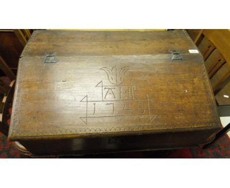
Lot 528
A mid 18th Century oak Bible box, the fall carved "AH 1748" opening to reveal three short drawers over a deep recess, with an oak and crossbanded front, on moulded plinth base, together with a Christians Complete Family Bible 1790 printed the the executors of B. Jackson, with handwritten pen inscriptions relating the the Hamer family, and AFTER J HUGH JOHNSON "Turkey and Asia Biblical Regions, The Holy Land and its borders", engraved map of the Middle East, and AFTER JOHN MACNAB "Sketch Map of the Region of the Exodus to illustrate alternative view of the route of the Israelites", hand coloured engraving by J.Bartholomew


![A 17th century tinted map of Flintshire by John Speede [sic] with inset maps of St Asaph, and Flint, and an inset picture of](https://cdn.globalauctionplatform.com/c996d5cc-9283-4156-a394-a656009dcc9d/c884dea5-e776-4d5a-e13b-e9e3aec1135a/468x382.jpg)


![[MISCELLANEOUS] Shore, W. Teignmouth. Kent, Black, London, 1907, decorative green cloth, top edges gilt, paper-protected colo](https://cdn.globalauctionplatform.com/949ca586-04ad-44dc-9856-a64a0095c2f3/d5494d0c-65b7-4821-f256-84eafebb6fe7/468x382.jpg)
Lot 215
[MISCELLANEOUS] Shore, W. Teignmouth. Kent, Black, London, 1907, decorative green cloth, top edges gilt, paper-protected colour plate illustrations by W. Biscombe Gardner, folding map, quarto (hinges tender); 'Grey Owl' [Archibald Belaney]. The Men of the Last Frontier, reprint, Country Life, London, 1935, grey cloth, plate illustrations from photographs, SIGNED BY AUTHOR, octavo; Course, Captain A.G. Painted Ports. The Story of the Ships of Devitt & Moore, first edition, Hollis & Carter, London, 1961, boards, dustjacket, plate illustrations from photographs, octavo; and eight other works, (11).
![[MAP] John Owen & Emanuel Bowen 'Cambridgeshire', engraved county map, circa 1720, hand-coloured in outline, 18.5cm x 12cm.](https://cdn.globalauctionplatform.com/949ca586-04ad-44dc-9856-a64a0095c2f3/6dd1f93e-6df8-497d-c126-c68d1551b364/468x382.jpg)

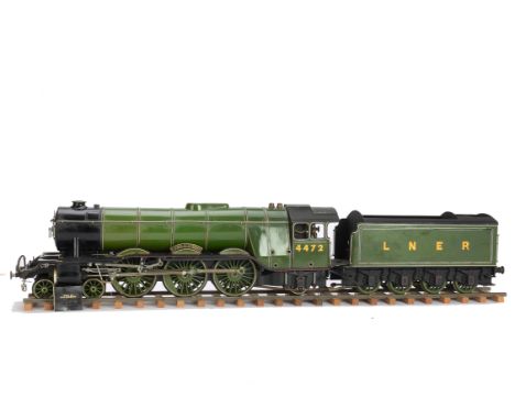
Lot 452
A 2½" Gauge Live Steam LNER 'Flying Scotsman' Locomotive and Tender, finished to a very high standard in LNER apple green as no 4472, built to Model and Allied Publications (MAP) drawings, and featuring authentic 3-cylinder drive with conjugated valve gear, pressure gauge, water gauge, lever reverse, mechanical axle-driven water pump and hand pump to tender, overall VG-E, appears never steamed, lacks ashpan, grate and whistle, together with set of MAP drawings (sheets 1-4), book of matches stating 'built by M H Mounsdon' (which may or may not relate to this engine!) and short length of display track (5)
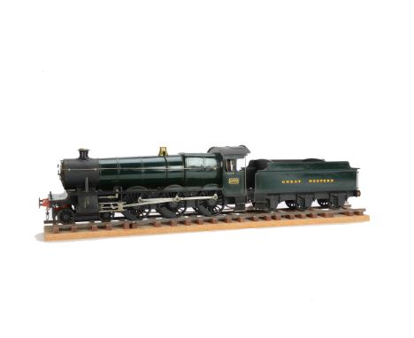
Lot 453
A 2½" Gauge Live Steam GWR 'Grange' class Locomotive and Tender, finished to a very high standard in GWR green as no 4972, (un-named) built to Model and Allied Publications (MAP) 'Purley Grange' drawings, and featuring authentic 2-cylinder drive, with pressure gauge, water gauge, lever reverse, mechanical axle-driven water pump and hand pump to tender, overall VG-E, appears never steamed, lacks ashpan, grate and whistle, together with set of MAP drawings (sheets 1-4) and short length of display track (4)
-
109182 item(s)/page