We found 109198 price guide item(s) matching your search

Refine your search

Year

Filter by Price Range
  • List
  • Grid
  • 109198 item(s)
    /page

Lot 380

Debes, Lucas JacobsonFaeroae, & Faeroa Reserata: that is a Description of the Islands & Inhabitants of Foeroe... London: William Iles, 1676. First edition in English, 12mo, folding map, folding plate in facsimile, woodcut, 19th or 20th century morocco by Grieve of Edinburgh, a little rubbing to covers

Lot 386

Graham, Robert CunninghameThe Carved Stones of Islay. Glasgow: James Maclehose & Sons, 1895. 4to, engraved title-page, map, 32 plates, original brown cloth, a little spotting and offsetting

Lot 387

Guernsey - Berry, WilliamThe History of the Island of Guernsey. London: Longman [&c.], 1815. First edition, 4to [viii], [4], xx, 21-348, folding aquatint frontispiece, folding map, and 28 aquatint plates, 4pp. list of subscribers, contemporary calf, spine worn with some loss at head

Lot 39

Sanson, NicolasCarte Generale de L'Italie. Paris, 1658, 57 x 41.5cm, hand-coloured engraved map, framed and glazed

Lot 391

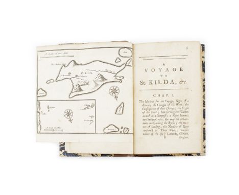
Highlands, a quantity, including Grant, AnneEssays on the Superstitions of the Highlanders of Scotland. 1811. 2 volumes, 12mo, modern quarter calf gilt; Sinclair, Sir John General View of the Agriculture of the Northern Counties and Islands of Scotland. 1795. 4to, 2 coloured folding maps, 1 folding plate, modern quarter calf;Anderson, John Prize Essay on the State of Society and Knowledge in the Highlands of Scotland. 1827. 8vo, contemporary cloth, worn; Bede, Cuthbert Clencreggan. 1861, 2 volumes, 8voProfeit, R.A. Under Lochnagar. Aberdeen, 1894. 4to, original black morocco, rebacked retaining part of original spine; Murray, J.G. The Royal Dee. 1898, 4to, presentation copy to Robert Ford from the author; Maclagan, R.C. The Games & Diversions of Argyleshire. Folk Lore Society, 1901, 8vo; Bede, C. Argyll's Highlands. 1902, 4to; Anderson, Robert Deeside, Painted by William Smith Junr. 1911. 4to; Stirton, John Crathie and Braemar. Aberdeen, 1925, 4to, with 2 letters to the author bound in, original quarter morocco; [Clan Campbell] An Account of the Depredations committed on the Clan Campbell. Edinburgh, 1816. 4to, contemporary half calf, spotting, joints rubbed; M'Neill, John Report to the Board of Supervision... on the Western Highlands and Islands. 1851, folio, contemporary calf, rebacked; Campbell, Duncan Reminiscences and Reflections of an Octogenarian Highlander. Inverness, 1910. 4to, original calf, rebacked; Mackay, G.G. On the Management of Landed Property in the Highlands of Scotland. 1858, 8vo, original cloth; Watson, J. & W. Morayshire Described. Elgin, 1848, 8vo, folding map, original cloth, hinges repaired; Mackay, W. Urquhart and Glenmoriston. Inverness, 1893, 8vo, original cloth, rubbed, owner's name on title; Gunn, Adam, editor Sutherland and the Reay Country. 1897, 8vo, original cloth; Beaton, A.J. The Social and Economic Condition of the Highlands of Scotland. Stirling, 1906; Mackay, Angus The History of the Province of Cat. Wick, 1914. 4to, original cloth, annotation to title; MacDonald, A. Story and Song from Loch Ness-Side. 1914, 8vo, original cloth; McKay, John G. More West Highland Tales. 1940-60. Volumes 1-2, dustwrappers; and others, 19th and 20th century (quantity)

Lot 392

Iceland - 2 works, comprising Troil, Uno vonLetters on Iceland. London, 1780. First edition, 8vo, frontispiece bound at p.257, folding map, contemporary calf, worn, joints split; Du Chaillu, P.B. The Land of the Midnight Sun. 1899. 8vo, folding map, illustrations, contemporary green calf gilt, red morocco lettering piece, slightly spotted (2)

Lot 395

Jameson, RobertAn Outline of the Mineralogy of the Shetland Islands, and the Island of Arran. Edinburgh: William Creech, 1798. First edition, 8vo, folding map, single-page map, plate, modern quarter calf, a little darkening and offsetting

Lot 398

Loch, JamesAn Account of the Improvements on the Estates of the Marquess of Stafford. London: Longman [&c.], 1820. First edition, 8vo, folding map hand-coloured in outline and 39 engraved plates and plans (3 hand-coloured and folding), contemporary calf, spine gilt, slight offsetting

Lot 40

Saxton, Christopher - LancashireLancastriae. [London,] 1579, 50 x 41cm, hand-coloured engraved map, framed and glazed, not laid-down

Lot 402

MacAulay, KennethThe History of St Kilda. London: T. Becket and P.A. De Hondt, 1764. 8vo, folding map, lacking half-title, contemporary calf, early ownership signature to paste-down endpaper [ESTC T90614]

Lot 405

Martin, MartinA Late Voyage to St. Kilda. London: D. Brown and T. Goodwin, 1698. First edition, 8vo, half-title, folding map, folding plate, modern quarter calf, paper flaw to pp.147-8 with no loss to text, advertisement leaf misbound but present [ESTC R12939]

Lot 412

Orkney & Shetland, a collection of 72 booksA Letter respecting Shetland, to the Honourable The Highland Society of Scotland. Edinburgh: J. Ritchie, 1803. 8vo, modern boards; Peterkin, Alexander Notes on Orkney and Zetland. Edinburgh: Macredie, Skelly, and Company, 1822. Volume 1 (all published), 8vo, contemporary half calf; [Idem] Rentals of the Ancient Earldom and Bishoprick of Orkney. Edinburgh, 1820. 8vo, contemporary brown half morocco gilt, neatly rebacked; Gifford, Thomas An Historical Description of the Zetland Islands. London: J. Nicholson, 1786. 4to, folding map, modern brown half morocco gilt; The General Grievances and Oppression of the Isles of Orknay and Shetland... Edinburgh, 1750. 8vo, modern half morocco; Neill, Patrick A Tour through some of the Islands of Orkney and Shetland. Edinburgh: A. Constable and Company, 1806. 8vo, original boards, bookplate of Mary Elizabeth Edmondston; "Thulensis" A Letter to the Right Hon. Lord Viscount Althorp... London: printed by Richard Taylor, 1832. 8vo, without covers; Weld, Charles Richard Two Months in the Highlands, Orcadia, and Skye. London: Longman, Green, Longman, and Roberts, 1860. 8vo, lithographed plates, modern red quarter morocco; Traill, Walter Vindication of Orkney. Edinburgh: printed for the Author by P. Neill, 1823. 8vo, later half-calf; Dunn, Robert The Ornithologist's Guide to the Islands of Orkney and Shetland. London, 1837. 8vo, contemporary red half-calf; Barry History of the Orkney Islands. London: Longman, Hurst, Rees, and Orme, 1808. 4to, folding map, contemporary calf rebacked; and 61 others, sold not subject to return (72)

Lot 413

Oxfordshire - Skelton, Joseph - Large Paper Subscriber's CopySkelton's Engraved Illustrations of the Principal Antiquities of Oxfordshire, from Original Drawings by F. Mackenzie. Oxford, 1823. Large 4to, large paper Subscriber's copy ("Subscription copy" at head of frontispiece), engraved frontispiece, title-page,. map and 48 plates on India Paper, engraved illustrations on the letterpress, list of subscribers, contemporary dark blue morocco panelled morocco gilt, g.e., a little light spotting, slightly rubbed

Lot 417

Scotland, a collection, including Beattie, WilliamScotland Illustrated in a Series of Views. 1838. 2 volumes, 4to., engraved titles and plates, maroon morocco, lacks the map, worn, one hinge broken; Simpson, J.Y. On an Old Stone-Roofed Cell or Oratory in the Island of Inchcolm., extract from Proceedings of the Society of Antiquaries of Scotland, p.449-494, with Mss. additions by Dr. Petrie., 4to, original cloth, morocco label, spine worn; Innes, Thomas A Critical Essay on the Ancient Inhabitants of the Northern Parts of Britain, or Scotland. 1729. 2 volumes, 8vo, contemporary calf; Epistolae Jacobi Quarti, Jacobi Quinti et Mariae Regum Scotorum. Edinburgh, 1722, 2 volumes, 8vo, contemporary calf; Graham, James, Marquis of Montrose Memoirs. Edinburgh, 1756, 8vo, contemporary calf, worn; Lindsay, Robert The History of Scotland. Edinburgh, 1778. 8vo, contemporary calf, worn; Henderson, A. The Life of John Earl of Stair. London, [c.1746], 12mo, contemporary calf, stained, worn, crudely repaired; Fletcher, Andrew Political Works. Glasgow: R. Urie, 1749. 12mo, head of title torn away, contemporary calf, worn; Crawfurd, David Memoirs of the Affairs of Scotland. Edinburgh, 1767. 12mo, contemporary calf, worn; Scott, Walter Letters on Demonology and Witchcraft. 1836, Second edition, 12mo, engraved frontispiece, contemporary calf, worn; and others on Scotland; sold not subject to return

Lot 42

Scotland, 8 mapsMcKenzie, Murdoch The North-West Coast of Scotland, 1776, 110 x 98cm, bound into covers; A Travelling Map of Scotland... hand-coloured, 58 x 41cm, linen-backed, folding; Thomson, John A Guide to Loch Catherine and Loch Lomond, 38.5 x 42.5, folding; both contained together in one small case; Betts, John New Map of Scotland... hand-coloured in outline, 78 x 65cm, linen-backed, folding, original green cloth gilt case; Hall, S. Scotland, hand-coloured in outline, 53.5 x 42cm, linen-backed, folding, original covers; Black, A.&C. Road and Railway Travelling Map of Scotland, hand-coloured, 65.5 x 85.5cm, linen-backed, folding, original green cloth gilt covers; Bartholemew, J.G. The Royal Scottish Geographical Society's Atlas of Scotland. Edinburgh, 1895. Folio, original blue half-morocco gilt; and 3 others, including one map (10)

Lot 426

Shaw, LachlanThe History of the Province of Moray... Elgin: J. Grant, 1827. 4to, folding map (some tears and repairs) hand-coloured in outline, 14 hand-coloured plates, contemporary calf, rebacked, some tears and repairs to map, early gift inscription and small section cut from title-page; and a copy of the first edition, 1775, in contemporary morocco gilt (2)

Lot 437

Wallace, JamesAn Account of the Islands of Orkney. London: Jacob Tonson, 1700. 8vo, folding map, folding plate, contemporary calf rebacked, bookplate, small stamp on loose flyleaf reading 'Bibliotheca Heberiana' [ESTC R34706]

Lot 51

Crane, WalterTriplets. Comprising the Baby's Opera, The Baby's Bouquet, and The Baby's Own Aesop. London: George Routledge & Sons Ltd., 1899. Oblong 4to, number 160 of 750 copies, original quarter vellum over brown cloth gilt, ownership inscription to fly-leaf, some foxing and spotting throughout, some soiling to covers and damage to spine ends; Aldin, Cecil The Romance of the Road. London: Eyre and Spottiswoode Limited, 1928. Folio, number 100 of 200 copies signed by Cecil Aldin, folding map, frontispiece, 9 plates, original vellum gilt, bookplate, inscription in blue biro, a little light foxing, slight discolouration and marking to covers (2)

Lot 85

Fea, JamesConsiderations on the Fisheries in the Scotch Islands... London: printed for the Author, 1787. 8vo, folding map, two parts in one volume, 6pp. subscribers list at end, new endpapers, modern quarto morocco backed cloth, [ESTC:T9098]

Lot 90

Jacobite Rebellion, 14 volumes, including Johnstone, Chevalier deMemoirs of the Rebellion in 1745 and 1746. 1820. 4to, portrait, plan, modern quarter calf, uncut; Lockhart, George The Lockhart Papers. 1817. 2 volumes, 4to, modern red quarter morocco; [Forbes, Duncan] Memoirs of the Life of Lord Lovat. London, 1746, 2 copies, 8vo, contemporary calf gilt, rebacked, & modern quarter morocco; [Burton, John] A Genuine and true Journal of the most miraculous escape of the Young Chevalier. London, 1749., tear at foot of title repaired, modern quarter calf; Henderson, A. The Life of William Augustus Duke of Cumberland. 1766, 8vo, frontispiece, contemporary calf; Macdonald, A.R. The Truth about Flora MacDonald. 1938. 4to, two-tone cloth; Maxwell, James Narrative of Charles Prince of Wales' Expedition to Scotland in the year 1745. 1841, 4to, contemporary quarter calf, rubbed; Gordon, James Remarks on Colonel Stewart's Sketches of the Highlanders. 1823, 8vo, contemporary half calf, rubbed; Stewart, David Sketches of the Character, Manners, and Present State of the Highlanders of Scotland. Edinburgh, 1822. 2 volumes, 8vo, large hand-coloured folding map, contemporary half calf gilt ; and 2 others (14)

Lot 96

Military History, a quantity, including Shipp, JohnThe Military Bijou. 1831. 2 vol., 8vo, modern boards; Farie, R. Campaign in France in the year 1792. 1849, 8vo; Younghusband, G.J. The Story of the Guides. 1908, 8vo; Gretton, G. le M. The Campaigns and History of the Royal Irish Regiment from 1684 to 1902. 1911, 4to; [Blampied, H.J.] With a Highland Regiment in Mesopotamia 1916-1917. Bombay, 1918, 8vo; Lowe, W.D. War History of the 18th (S.) Battalion Durham Light Infantry. 1920, 8vo; Thompson, R.R. The Fifty-Second (Lowland) Division 1914-1918. 1923, 8vo; Ewing, J. The Royal Scots 1914-1919. 1925, 2 vol., 8vo; Wauchope, A.G. A History of The Black Watch [Royal Highlanders] in The Great War. 1925- 26, 3 vol., 8vo; McCance, S. History of the Royal Munster Fusiliers. 1927, vol. 1 only, 4to; Ross of Bladensburg, John The Coldstream Guards 1914-1918. 1928, 3 vol. including map vol., 8vo; Gardyne, C.G. The Life of a Regiment. The History of The Gordon Highlanders. 1929, 3 vol., 8vo, dust-jackets; Gillon, S. The K.O.S.B. in the Great War. [c.1930], 8vo; Erskine, D. The Scots Guards 1919-1955. 1956; and a quantity of similar material, mostly original cloth

Lot 289

Two framed Saxton maps; Cheshire and Gloucestershire in the sixteenth century, together with a framed map of Hereford

Lot 116

Parcel of pictures, prints and a Landshapes map of the English Lake District

Lot 214

Framed Welsh language map of Wales, framed collage of insects and a framed silkwork bird and flower picture

Lot 451

V WATSON oil on board - still life, pewter flagon with fruit and a reproduction map of 'The Road from Welshpool to Carnarvan'

Lot 122

ANTIQUE MAP OF BEDFORDSHIRE BY GREENWOOD & REPLICA MAP SURREY

Lot 321

George Morland, Leicester Shire, hand-coloured county map, 35cmx 40cm, reproduction map, Northamptonshire 1870; and four topographical prints. (6)

Lot 343

A collection of antiquarian prints and engravings, "Woburn Abbey The West Front", "Horton House Northamptonshire", "Warwick Castle", 1889 Map of Bedford, "La Mode Illustree"34cm x 24cm, and two hand coloured engravings John Hayter/W H Mote/J J Penstone "Miss Kate Sneyd" and "Miss Phillipson" 20cm x 15cm. (7).

Lot 63

A quantity of farming and agricultural books, 1959 Perkings Engines hand books and an early Ford road map.

Lot 528

Three 19th century engravings of Wanstead, together with a reproduction 16th century map of Essex, and other prints

Lot 580

An 18th century map, a draught of the sands, shoals, buoys, beacons and sea marks, from the South Foreland to Oxford, from the original plates by Captain Greenville Collins, 43 x 51cm

Lot 581

A large contemporary printed map of London, 82x123cm

Lot 1024

A framed and glazed Ordnance Survey map depicting Coddenham, Great Blakenham etc.; together with a 19th Century coloured engraving

Lot 253

A domed leather-bound trunk decorated with a map of the World

Lot 1573

A collection of posters including The Pet Shop Boys promotional poster, map of Romford and various other reprints.

Lot 1595

An Early 20th century Airess Railway Map Of South Wales. Old LMS maps in four sheets. Essex maps vintage Motoring and Hiking Map and others.

Lot 1619

A framed and glazed map of Essex by Richard Blome, approx 41.5cm x 34.5cm.

Lot 1639

A framed and glazed J Rapkin 1851 map of England and Wales, approx 53.5cm x 73.5cm.

Lot 453

Andrew Johnston, coloured engraving, A New Map of The North Part of Scotland and an Ogilby road map London to Portsmouth 36 x 45cm and 32 x 43cm

Lot 485

Mozart's Quartets arranged in four volumes (Dedicated to the Prince of Wales and printed by R. Cocks & Co.) for violins and tenor, Tunes in Miniature and distressed map

Lot 68

Boxed brass map reader and compass

Lot 673

FRENCH SCHOOL (18th CENTURY)A Map of IrelandEtching, 35 x 46.5cm

Lot 2103

A framed Map of Herefordshire together with a framed Lithograph of Views from the Malvern Hills

Lot 2120

A quantity of prints including 'End of Play' by Lawson Wood, Paul Henry print of Irish Landscape, framed map showing the Earldom's of Scotland, etc.

Lot 1071

After Ruscelli 'Tabulae Europae III' handcoloured map, from Ptolemy's Geographica, circa 1599, 13cm by 17.5cm and a collection of reproduction maps including Dublin & Australia; with other prints, framed and glazed (9)

Lot 343

WILLETT (R), (A PARISHONER), A MEMOIR OF HAWARDEN PARISH, FLINTSHIRE, containing short introductory notices of the Princes of north Wales, folding frontis map, 3/4 leather with marbled boards, Chester, 1822 (1)

Lot 345

Auction Catalogue - THE TREVALYN ESTATE, at Rossett, Marford and Gresford, sold at auction on November 13th 1919, including map

Lot 378

A NEW MAP OF TROPICAL AMERICA NORTH OF THE EQUATOR, comprising West Indies, Central America, Mexico, New Canada and Venezuela, by H. Kiepert and published Dietrich Berlin 1858, sixty five sections linen backed, 105cm x 175cm, in slip case CONDITION REPORT: Map with some browning along the horizontal fold lines. Minor corner lifting / creasing to a few of the map sections. Canvas ok but lightly browned. Map slightly curved when folded together. Caser with general light age wear, old ink name rubbed out to the makers label.

Lot 402

STEELE (H), POLICING THE ARCTIC, with folding map and black and white plates, Jarrolds, 1936; HUNT (J), THE ASCENT OF EVEREST, Hodder & Stoughton 1953; IRVING (R), THE ROMANCE OF MOUNTANEERING,, reprint 1935; and other books on mountaineering etc (Qty)

Lot 447

Robert Morden, 17th century engraving, A hand coloured map of Shropshire, 38cm x 44cm, (laid), with four other Robert Morden maps for South Wales, Huntingdonshire, Monmouth and Herefordshire (5)

Lot 448

Thomas Kitchin, Engraving, Map of Cheshire, 16cm x 24cm,with other maps of Shropshire, Staffordshire and Cheshire, engravings from 'London and its Vicinity' by George Cook, and other botanical plates etc (Qty)

Lot 450

John Ogilby, Hand coloured engraving, Map of the road from Ipswich to Norfolk, 32.5cm x 45cm, Framed and glazed, With two maps of Shropshire (3) CONDITION REPORT: This appears to be an original map within a later frame - the edges of the map have been folded over - this is not visible from the front. Lightly browned to the front, the back of the map is heavily browned showing shadows of the patterns on the front. Some old creases. There is no text on the back of the map.

Lot 906

A collection of wristwatches, Rotary, Sekonda, Citizen, etc., and two map gauges

Lot 1185

A framed Map of Herefordshire by Robert Morden

Lot 1018

An Oak framed copy of 'A New Map of the County of Warwick', divided into hundreds, printed for C. S. Smith, 172 Strand, January 6th 1801

Lot 1020

An oak framed Map of Oxfordshire copied from his famous Atlas titled 'The Theatre of the Empire of Great Britaine'

Lot 2003

GAGE, John, History and Antiquities of Suffolk: Thingoe Hundred, John Deck, Bury St Edmunds 1838, 4to cloth, frontis map and plates, damp marked on front board and lower fore edge of map and title page showing damp mark. A working copy (1)

Lot 2004

SHOBERL, F., Suffolk; or Original Delineations, London 1818, 8vo, re-bound recently maroon cloth, folding map and 13 plates; L'ESTRANGE, John (Ed), The Eastern Counties Collectanea, Norwich 1872-3, 8vo cloth (2)

Loading...Loading...
  • 109198 item(s)
    /page

Recently Viewed Lots