We found 109182 price guide item(s) matching your search

Refine your search

Year

Filter by Price Range
  • List
  • Grid
  • 109182 item(s)
    /page

Lot 1106

Two framed maps of Herefordshire; one being by John Cary (15" x 13" incl. frame), the other 8 1/2" x 10 1/2" and a plan of the City of Hereford, and of the Inclosures within the liberties thereof distinguishing the divisions of the several parishes from an actual survey by H. Price, 15" wide x 10 1/2" plus frame, plus a framed map of Huntington, 23" x 17".

Lot 1107

Two small framed Maps including Cambridgeshire published by Arch. Fullarton & Co. Glasgow, 9 1/4" wide x 12" tall and a Map showing Worcester, Shropshire and Montgomery roads from page III of a book, hand coloured, 4" wide x 7" tall excluding frame

Lot 1143

A framed map of Monmouthshire, published London 1787 by J. Cary, the map being 9'' x 11''

Lot 1237

A framed Map of The Channel Islands Archipelago, sheet 1, 1st edition Alderney & Burou, f28'' x 16 3/4''.

Lot 1255

A quantity of small Home Guard books, training manuals, map reading, revised edition from Dusk to Dawn following the standown of the Home Guard in 1945 etc.

Lot 1325

A folder of black and white wartime Photographs of pilots resting, squadrons, etc together with a laminated map of a training area in the Brecon Beacons, Hawker, Nimrod and Vickers aeroplanes, etc.

Lot 1334

A quantity of Home Guard training manuals: Camouflage, Rescue, Battle Drill, Small Arms Training , Book of War Cartoons, Target cards, Sniper Training, Hand Grenade no. 36, 68 and 69, black and white photographs of mine planting, map, etc.

Lot 1348

A quantity of Maps including Ordnance Survey maps of Birmingham, Wolverhampton, Shrewsbury and Welshpool, National Geographic maps of Asia and Europe and a reproduction John Speede Map of Herefordshire.

Lot 1481

A quantity of Map prints (some duplicated) of counties in England, plus a framed map of one of the duplicate prints of Chester, Norfolk, Shropshire etc.

Lot 22

A 17th-century later hand coloured map of Essex by Robert Morden, published in 1695 glazed in slender Hogarth frame

Lot 283

The Complete Works of William Hogarth, The Life of Robinson Crusoe, six other books and a OS map of Doncaster

Lot 416

Victorinox Swiss army knife, wooden folding rule, wood and brass spirit level, map measurer and three other pen knives (7)

Lot 274

Map of Suffolk by Robert Morden, two maps of West Riding of Yorkshire, dated 1793, tapestry map of England and Wales, agricultural print of Conway Tubular Bridge

Lot 276

Two Victorian prints of Scarborough Castle, another print of Scarborough beach, an illustration of The Nave of York Cathedral, an unframed map of East Yorkshire, small enamel on steel picture of a field, two small painted countryside scenes

Lot 637

Very Large Wall Hanging Early Continental Roll Map of Asia in 20th Century: 152 x 202cm ( rips noted)

Lot 638

Very Large Wall Hanging Early Continental Roll Map of Germany & Central Europe in 20th Century: 228 x 221cm

Lot 639

Very Large Wall Hanging Early Continental Roll Map of Germany in 20th Century: 135 x 171cm

Lot 640

Very Large Wall Hanging Early Continental Roll Map of Europe in 20th Century: 208 x 174cm

Lot 641

Very Large Wall Hanging Early Continental Roll Map of Europe in 20th Century: 177 x 211cm

Lot 1533

An engraved hand coloured map of Huntingdonshire titled "Huntingdonensis Comitatus - Huntingtonshire", by Johannes Blaeu, circa 1645, framed and glazed, 38cm x 43cm

Lot 1534

An engraved hand coloured map of Lincolnshire, by Robert Morden, circa 1695, framed and glazed, 40cm x 50cm

Lot 1536

An engraved hand coloured map of North Wales, by Robert Morden, circa 1695, framed and glazed, 36cm x 42cm

Lot 1537

A 19th Century engraved map of Norfolk by J. Archer, hand coloured in outline, framed and glazed, 19cm x 24cm

Lot 1018

David Noble, oil on board of a coastal scene, signed bottom right, 47 x 65.5cm, together with a map of The British Isles. (2).

Lot 1125

Binoculars, newspapers, books, map, etc:- One Box; Soft Toy Cat, Camera, etc in a Wig Tin.

Lot 1365

J. Cary Map of Derbyshire, approximately 51 x 35.5cm.

Lot 1412

Cigarette and Trade Cards, mainly in sets in albums, Players, Brooke Bond, Wills, Ordnance Map of Sheffield Medallion.

Lot 1423

Bartholomew's Maps, Dartmoor, Surrey, Dorset, Cornwall, London Transport, bus maps, Tramways map and timetable. 1930 Mrs Beetons shilling cookery book, Warnes model cookery and housekeeping book, etc:- One Box.

Lot 150

EPHEMERA, a collection of postcards, prints, newspapers, a map and ceramics, the postcards comprise approx 550 - 600 early - mid 20th century examples of 'tourist' type cards, 'saucy seaside' cards, topographical, sentimental and transport examples, the prints are by Chris Woodcock and feature Heavy Transport, the newspaper are 20th century commemorative editions, the map is an Operational Navigation Chart published by the Aeronautical Chart and Information Centre, United States Air Force in 1965 and covers Austria, Denmark, Czechoslovakia, Denmark, France, Germany, Luxembourg, Netherlands, Poland, Sweden and the UK, scale 1:1,000,000, the ceramics comprise twenty one tourism thimbles, a Warwickshire Coalfield plate and four Royal themed china pin dishes

Lot 162

EARLY 20th CENTURY GUIDEBOOKS, comprising 'The Mediterranean, Seaports and Sea Routes' a Handbook for Travellers, published by Karl BAEDEKER 1911, 'Paris and Environs with Routes from London to Paris', a Handbook for Travellers, published by Karl BAEDEKER 1913, 'Guide to the Holy Land' by Father Barnabas MEISTERMANN, Missionary Apostolic, published by Burns, Oates & Washbourne Ltd 1923, 'Paris seen in Four Days' published by A. Leconte with coloured map, 'Appendix to Baedeker's Handbook for Paris, published 1913 and Jerusalem and Bethlehem on One, Two or Three Days, published by Steimatzky Publising , Jerusalem, probably early 1940's

Lot 940

PAGE, J.L.W. The Rivers of Devon 1st.ed. 1893, London, 8vo orig. gt. dec. cl. 2 copies, plus HARDING, Lt. Col. A Paper on Tavistock Church & other papers 4to cl. numerous plts. plus 1 other on Devon & 1 map S. Devon coast (5)

Lot 186

A coloured map of Edenburgh (sic), after Georg Braun and Franz Hogenberg, with figures in the foreground, 34.5 x 45.5 cmClear margin, thinnest point 2 mm. Colours are strong, may have been retinted. Some light staining most noticeable to bottom right hand corner. Visible fold line.

Lot 187

An 18th century tinted map of Dorsetshire, 41.5 x 53 cm, and a facsimile map of Florence (2)Florence: modern copy condition goodDorset: Some staining and foxing. No visible tears. Colours have bled.

Lot 935

A Dutch map of The Mediterranean, Petrus on Paulus, 38 x 54cm

Lot 407

A group of prints and paintings to include a large abstract oil of a figure running through woodland, after Arthur Secunda; hand carved on polychrome wood, 'Distant Mountain', abstract, a large print 'Abbaye Royal de Pontevraud', a map of the British Empire, etc, all framed, some framed and glazed, the largest 91 x 81cm (9).

Lot 435

An 18th century Robert Mordan hand coloured map of Wiltshire, 35.5 x 42cm and a pair of W. H. Howarth watercolours of rural scenes, 16 x 25cm, all framed and glazed (3). CONDITION REPORT The map has areas of foxing and appears to have been glued to its backboard, resulting in some uneven tone to the right hand side. There is a vertical fold down the centre line of the map, a small tear to the upper section, not very noticeable. Further slight creases visible throughout.

Lot 436

An antique-coloured engraved map of Westmorland by Christopher Saxton and William Kip, 27.5 x 32cm, framed and glazed.

Lot 441

JOHN SPEED; a hand coloured engraved map 'The West Riding of Yorkshyre with the Most Famous and Fair City of York Described 1610', with title cartouche, six coats of arms and a plan of the City of York, 40.5 x 53.5cm, framed and glazed front and back, with printed information verso. CONDITION REPORT Yellowing and dust to the margins, no tears or creasing.

Lot 442

JOHN SPEED; 'The Countie Westmorland and Kendale the Chief Towne Described with the Armies of Such Nobles as Have Been Earles of Either of Them', Thomas Bassett and Richard Chiswell a hand coloured engraved map with an inset town plan of Kendal, 40.5 x 53.5cm, glazed front and back, with information verso. CONDITION REPORT Some yellowing to the margin and areas of mould to map under frame. No tears or creasing.

Lot 443

JOHN TALLIS; a 19th century hand coloured map and panorama of Liverpool, c1853, 36.5cm x 52cm, with an engraving of Lancelot's Hey, both framed and glazed (2). CONDITION REPORT It has been cut right up to where the engraving plate marks would be but it does appear to be original

Lot 524

SYERS (R), THE HISTORY OF EVERTON, including familiar dissertations of the people, with a map of Everton, 3/4 leather with marbled boards, Liverpool, 1830 (front board detached); THE STRANGER IN LIVERPOOL, 8th edition, with 'trade and commerce' table and fifty two engraved plates at the back, re-backed original boards, Liverpool, 1825; LACEY (L), edit, THE HISTORY OF LIVERPOOL FROM 1207-1907, red cloth with gilt decoration for The Conservative Club Liverpool (3).

Lot 525

A GENERAL AND DESCRIPTIVE HISTORY OF THE ANCIENT AND PRESENT STATE OF THE TOWN OF LIVERPOOL…., together with a circumstantial account of the true causes of it's extensive African trade, later 3/4 leather with marbled boards, Liverpool, J. McCreery, c1792; MOSS (W), THE LIVERPOOL GUIDE, including a sketch of the environs, with folding frontis map, engraved vignette to title, later 3/4 leather, Liverpool, 1801; THE PICTURE OF LIVERPOOL OT STRANGERS GUIDE, engraved folding map and device to title, later 3/4 leather, Liverpool, 1805 (3). CONDITION REPORT All heavily foxedAll rebound Larger volume has water stainsA picture of Liverpool fold out map is heavily foxed and with minor tears to edgesLiverpool guide map is water stained, foxed and with fold marks

Lot 526

THE LIVERPOOL DIRECTORY FOR THE YEAR 1766; containing an alphabetical list of the merchants, tradesmen and principal inhabitants, 28pp, with engraved plate and folding map, 3/4 leather with marbled boards and mounted gilt lettered title (1).

Lot 406

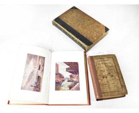
[MISCELLANEOUS] Cobham, Sir Alan. Twenty Thousand Miles in a Flying-boat. My Flight Round Africa, reprint, Harrap, London, 1931, original blue cloth, plate illustrations, INSCRIBED & SIGNED BY AUTHOR, octavo; Douglas, Lord Alfred. My Friendship with Oscar Wilde, limited edition of 1000, Coventry House, New York, 1932, blue cloth with paper title label to spine, portrait frontispiece, octavo; Bulmer, T. History, Topography, and Directory of Derbyshire, 1895, for the proprietors, Preston, as dated, half crimson leather, sixteen pages of period advertisements, folding map, quarto; and six other works in seven volumes, (10). Condition Report : Douglas: Spine with slight, even fading; spine label chipped, not affecting text; Bulmer: Spine head torn; covers stained; map and some index pages detached; lower fore-edge corner heavy browning throughout; sold with all faults, not subject to return. Condition reports are offered as a guide only and we highly recommend inspecting (where possible) any lot to satisfy yourself as to its condition.

Lot 408

[MAP]. SOMERSET Morden, Robert (c.1650-1703), 'Somerset Shire', engraved county map, hand-coloured in outline, 36.5cm x 42.5cm, framed and glazed. Condition Report : Generally good condition; slight surface creases below scale of miles; fresh colours. Condition reports are offered as a guide only and we highly recommend inspecting (where possible) any lot to satisfy yourself as to its condition.

Lot 306

A framed and glazed map of the Dover Straight, Western Part from the International Chart Series. H.75 W.108cm

Lot 510

John Speed Map of Yorkshire 1610 (unframed)

Lot 619

Robert Morden Map of The East Riding of Yorkshire circa 1700

Lot 620

Robert Morden Map of The North Riding of Yorkshire circa 1700

Lot 405

The German Occupation Of Jersey 1940/1945 Booklet including map Signed. Signed by Howard Butlin Baker. Good condition. All autographs come with a Certificate of Authenticity. We combine postage on multiple winning lots and can ship worldwide. UK postage from £4.99, EU from £6.99, Rest of World from £8.99

Lot 74

A continental time line map depicting 900 AD- 1900, 101 x 71 cm

Lot 707

A 20th century Danish pull down map showing world temperatures

Lot 1236

A LARGE VINTAGE 'FREYTAG & BERNDT' MAP OF AUSTRALIEN UND POLYNESIEN

Lot 1247

A LARGE VINTAGE 'DR HERMANN HACK' MAP OF EUROPA

Lot 1252

A LARGE FRAMED 50 STATE MAP OF THE UNTIED STATES OF AMERICA

Lot 198

Emanuel Bowen - 'An accurate map of the County of Essex divided into its Hundreds', 18th century, with hand colouring 70 x 51cm framed

Lot 334

Antique Robert Mordan Map of Essex in glazed frame

Lot 311

John Ogilby, The Road from Hereford to Leicester, double sided, 19 x 12cm; The Road from Exeter to Truro, with a map of Cornwall; Victorian map, British Possessions in the Mediterranean; and another, Islands in the Atlantic (4).

Lot 317

Philip Lea and Christopher Saxton, Warwick and Leicester Shires, hand-coloured map of counties, 39 x 53cm.

Lot 318

Johannes Blaeu, Leicestrensis, hand-coloured county map, 41 x 52cm.

Loading...Loading...
  • 109182 item(s)
    /page

Recently Viewed Lots