We found 109182 price guide item(s) matching your search
There are 109182 lots that match your search criteria. Subscribe now to get instant access to the full price guide service.
Click here to subscribe- List
- Grid
-
109182 item(s)/page


Lot 103
Bible in English - Holy Bible, containing the Old Testament and the New, bound with Apocrypha, The New Testament, (1683), (a3 torn), The Whole Book of [metrical] Psalms, with 6 double-page maps: The World, Paradise, The Promised Land, The Perigrinations, Map of Jurusalem, Pauls Missionary Journals, (a3 torn), folio, original calf, hinges weak, spine edges scuffed, numerous repairs to pages and maps throughout, some pages torn or strengthened, clasps lacking, 15 x 8in., [Stephen Swart, Amsterdam], 1679,


Lot 112
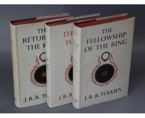
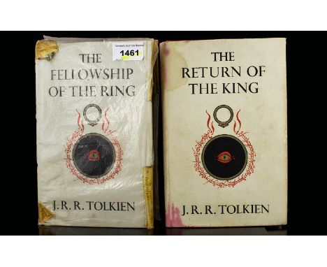
Tolkien, John Ronald Reuel - The Return of the King, first edition, original cloth in d.j., inner fly leaf with darkened strip, with folding map at rear, London 1955, together with The Fellowship of the Ring, 5th impression 1956 and The Two Towers, 4th impression, 1956, both cloth with d.j.'s (3)


Lot 125
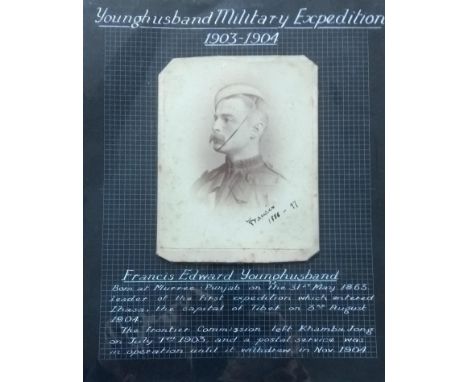
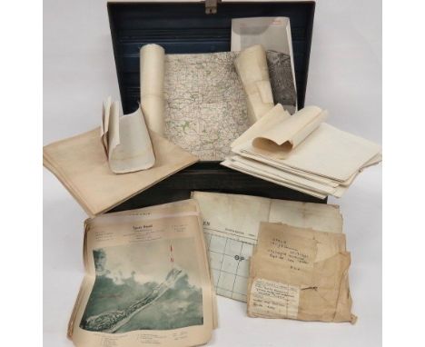
Signed photograph of Francis Edward Younghusband, dated 1886-7, letter signed by Col. Vickers, map and other ephemera related to the Tibet Mission 1903-04: 1904 mounted Waddell's Plan of Lhasa, March 1904; Skeleton Map of Sikkim, 1903; Sketch Map from Sikkim to Lhasa, 1903; Sketch Map of Bhutan, Sikkim and a portion of Tibet, 1903; cloth Sketch Map of Communication in Sikkim and Tibet, 1904; cloth route Sketch Map Tuna to Gyang-Tse Jong by Hazrat Ali, 1904; Skeleton Map of Tibet, 1903; Native Route Report Gyantse to Lhasa; mounted Extracts from staff diaries of the Tibet Mission Escort as reported by The India Gazette dated November 12, 1904 pp. 844-853


Lot 207
HERBERT EDWARD FORREST: 2 titles: THE VERTEBRATE FAUNA OF NORTH WALES, London, Witherby & Co, 1907, 1st edition, 28 plates, folding map at end as list, folding map with split at fold and small old repair, rebound (not recent) cloth, morocco gilt spine label; A HANDBOOK TO THE VERTEBRATE FAUNA OF NORTH WALES, London, Witherby & Co, 1919, 1st edition, original cloth, spine faded + GEORGE BOLAM: WILD LIFE IN WALES, London, Frank Palmer 1913, 1st edition, rebound (not recent), morocco gilt spine label (3)
Lot 264
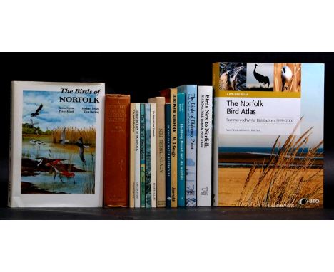
BERNARD BERYL RIVIERE: A HISTORY OF THE BIRDS OF NORFOLK, London, H F & G Witherby, 1930, 1st edition, 16 plates, folding map, original cloth gilt + MOSS TAYLOR, MICHAEL SEAGO, PETER ALLARD & DON DORLING: THE BIRDS OF NORFOLK, 1999, 1st edition, original cloth, dust-wrapper + MOSS TAYLOR & JOHN H MARCHANT: THE NORFOLK BIRD ATLAS, 2011, 1st edition, 4to, original cloth, dust-wrapper + KEITH DYE, MICK FISZER & PETER ALLARD: BIRDS NEW TO NORFOLK, 2009, 1st edition, original cloth, dust-wrapper + ANDY STODDART & STEVE JOYNER: THE BIRDS OF BLAKENEY POINT, 2005, 1st edition, original cloth, dust-wrapper + STEWART LINSELL: HICKLING BROAD AND ITS WILD LIFE, 1990, 1st edition, original cloth, dust-wrapper + E A R ENION: ADVENTURERS FEN, 1949, revised and extensively enlarged edition, original cloth, dust-wrapper + M J SEAGO: BIRDS OF NORFOLK, 1977, revised edition, original pictorial wraps + JOHN ANDREWS: BIRDS OF ANGLIAN WATER RESERVOIRS, 1992, original pictorial wraps + PETER R ALLARD: THE BIRDS OF GREAT YARMOUTH, 1990, 1st edition, original pictorial wraps + ANDREW BLOOMFIELD: BIRDS OF THE HOLKHAM AREA, 1993, 1st edition, original pictorial wraps + MOSS TAYLOR: THE BIRDS OF SHERINGHAM, 1986, 1st edition, original limp pictorial cloth + LEE G R EVANS: RARE VAGRANT, SCARCE MIGRANT AND RARE BREEDING BIRDS IN NORFOLK UP TO AND INCLUDING 1997, 1998, 1st edition, original pictorial wraps + GEOFFREY KELLY: THE NORFOLK BIRD ATLAS, 1986, 1st edition, original pictorial wraps (14)

Lot 278
PETER SCOTT: 2 titles: WILD GEESE AND ESKIMOS: A JOURNAL OF THE PERRY RIVER EXPEDITION OF 1949, London, 1951, 1st edition, signed and inscribed to title page, coloured frontis + 36 illustrations (mainly full page from photographs) + 2 maps and map end papers as called for, original cloth gilt, spine sunned; THE SWANS, London, Michael Joseph, 1972, 1st edition, signed and inscribed to title page, quarto, original cloth gilt + MYRFYN OWEN: WILDFOWL OF EUROPE, foreword Peter Scott, illustrated Hilary Burn, 1977, 1st edition, Wildfowl Trust printed piece tipped in to front free end paper, signed by the author, artist and one other signature, quarto, original two-tone pictorial cloth gilt, dust-wrapper + IAN WALLACE: DISCOVER BIRDS, foreword Peter Scott, illustrated Philip Sayer, 1979, oblong, original pictorial laminated boards (4)


Lot 256
Waugh (Evelyn) Remote People, first edition, plates (one becoming loose), folding map, foxing, light browning to endpapers, original cloth, dust-jacket, spine slightly browned, spine ends and corners a little chipped, creasing and fraying to head and foot, red stain to upper panel, not affecting lettering, 8vo, 1931.

Lot 1132
James Bond From Russia with Love (1963) A Framed Section of Map depicting vicinities in Moscow including illustrations of historical buildings, a football club & a communal Park. Maps of this kind would have been used throughout the film, particularly when Rosa Klebb (Lotte Lenya) meets with Tatiana Romanova (Daniela Bianchi) as part of a plot to steal a decoding machine for SPECTRE. Maps were also produced for scenes including the Soviet Consulate & government offices. Linen backed in a framed display with corresponding images. Display measuring 21 x 16 inches. Provenance: With Certificate of Authenticity..


Lot 338
{ Option of lots: 338 } Savoy Map – Tokyo Our New Savoy Maps Selection Presents Each City From A Modern, Monochromatic Viewpoint, Designed To Look Like The Negative Of A Photograph. View Your Favourite City Through Fresh New Eyes. Framed In Matt Black Oak With Brass Trim. 90 X 5 X 109 Cm RRP £1075


Lot 253
Marble Map Coffee Table New York An engaging, limited edition piece, representing some of the world’s most iconic cities to prompt discussion, inspire travel or evoke memories. Map drawings are translated onto the marble which is laser-cut and inlaid with brass, then polished to achieve a smooth, flush surface. Each piece requires absolute precision and takes many hours to create.An elegant and refined coffee table to spark a conversation, infusing and activating the senses with rich, contrasting materials and plenty of drama. 120 x 120 x 38 cm 150kg RRP £10825

Lot 418
WW2 German Maps and Target Maps of Various British Cities varied selection of maps including 12 x Blatt 14 coloured paper map of Lincoln... Various target maps and printed photo of Hull including the docks... Map showing Sheffield Power Station... Maps of Nottingham Gas Works... Small selection of various maps... 2 x 1972, 30 mm shells and dummy heads. All contained in a green painted tin trunk.

![[MAPS]. Senex, John (1678-1740). 'The Road from Exeter to Barnstable', engraved ribbon map, hand-coloured, 16cm x 23cm, fram](https://cdn.globalauctionplatform.com/1671b6e3-48bb-41c7-9a0b-a9d200fb622d/c365e16d-29ef-4c3f-9a02-a9e700dcb393/468x382.jpg)
![[HISTORY]. MILITARY Arnot, B. Douglas. That White Horse. A Brief History [of] the 629 (9th) Field Squadron Royal Engineers,](https://cdn.globalauctionplatform.com/1671b6e3-48bb-41c7-9a0b-a9d200fb622d/cd7a2bbc-a377-46a6-9802-a9e700dc7463/468x382.jpg)
Lot 357
[HISTORY]. MILITARY Arnot, B. Douglas. That White Horse. A Brief History [of] the 629 (9th) Field Squadron Royal Engineers, first edition, Gale & Polden, Aldershot, 1947, dark blue cloth, illustrations, octavo; Brown, Rev. Frederick. From Tientsin to Peking with the Allied Forces, Kelly, London, 1902, pictorial ochre cloth, portrait frontispiece, illustrations, two-page publisher's list, octavo; and five other items, including a folding Daily Mail Bird's-Eye Map of the [Great War] British Front, Section 1, (7).


Lot 541
A selection of early 20th Century Survey maps of India to include a selection of railway maps, road maps and region maps all heliozincographed at the Survey of India Offices in Calcutta. Most paper, some being canvas backed. The maps include Central India & Central Provinces 1922, Mysore 1916, Road map of India 1926, Bengal & Eastern States 1937, Kashmir & Jamu 7 Punjab 1915, Bengal & North Western and Rohilkund & Kumaon Railways. 12 in total.
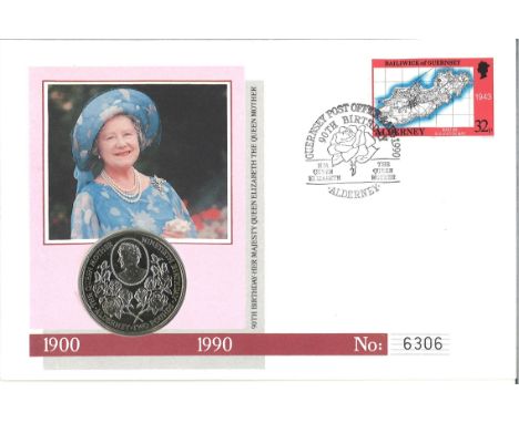
Lot 336
HM Queen Elizabeth The Queen Mother 90th Birthday official coin FDC PNC. Contains a 1990 £2 crown coin, struck by the Royal Mint in cupro-nickel to give the finest quality finish, it features a delightful cameo portrait of Her Majesty surrounded by pearls. Alderney's 1989 32p definitive issue stamp, showing a wartime map of the island. Guernsey Post Office 90th Birthday Alderney 4th August 1990 postmark. Good condition

Lot 403
CHURCHMANS, odds, inc. Army Badges of Rank, Association Footballers, Boxing, Boy Scouts, Frisky, Phil May Sketches, Sectional Cycling Map, 3 Jovial Golfers, Well-Known Ties, World Animals of the World; large, Holidays in Britain, Eastern Proverbs, Italian Art, Warriors of All Nations etc., in modern album, VG to EX, 250*
-
109182 item(s)/page