We found 109182 price guide item(s) matching your search
There are 109182 lots that match your search criteria. Subscribe now to get instant access to the full price guide service.
Click here to subscribe- List
- Grid
-
109182 item(s)/page


Lot 2419
After Jodocus Hondius - 'The Countie and Citie of Lyncolne described with the Armes of Them that have bene Earles Thereof since the Conquest', hand-coloured double-sided map bearing town plan for Lincoln and coats of arms, the description of Lincolnshire with table and English text verso, published by Thomas Bassett of Fleet St and Richard Chiswell of St Paul's Churchyard, circa 1610, the full sheet approx 42 x 55cm; and Johannes Blaeu - engraved County Map of Northumbria, later hand-coloured, with coats of arms, 41 x 50cm (2)


Lot 2424
'The County of Suffolk reduced from the large map in six sheets, surveyed by Joseph Hodskinson, and planned from a scale of half an inch to one mile', published London, January 1st 1787, printed for William Faden, Geographer to the King, Charing Cross, folding map on linen, hand-coloured outlines to the hundreds, 58 x 77cm

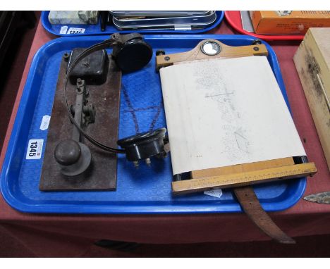
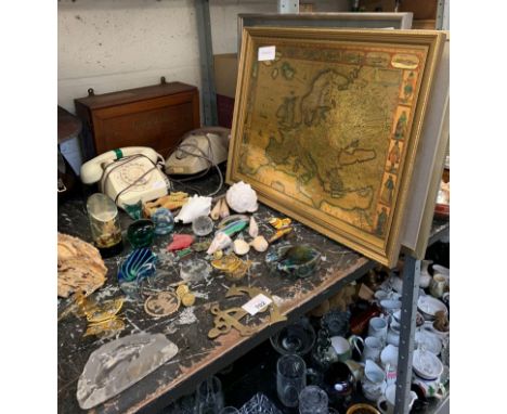
Lot 2020
PALMER CLARKE, J. (Photographer). Moreton Hall, Bury St. Edmunds. Nd, early 20th cent. A bound collection of 21 high quality b/w photographs of Moreton Hall. Presented in full leather with gilt titling to front board. Aeg. Together with. COOKE, G. A. A Topographical and Statistical Description of the County of Suffolk. Sherwood, Jones & Co, London. C. 1805. 4 engraved plts and folding col. county map. Presented in cloth binding. And 1 other. [3]Condition report: Moreton Hall – some loss to leather at base of spine.

Lot 2425
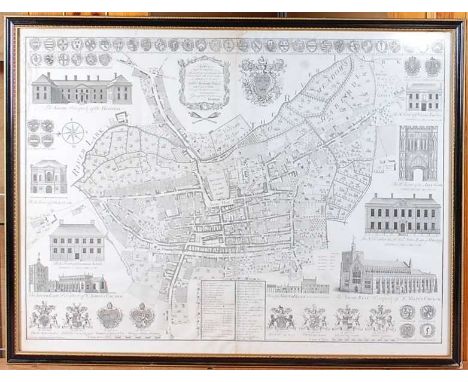
Thomas Warren - 18th century survey map of the Borough of St Edmundsbury in the County of Suffolk, having town plan of Bury St Edmunds and topographical engravings of the principal buildings and coats of arms of important local families, published according to Act of Parliament 1776, monochrome engraving, 70 x 96cm, later framedCondition report: Map is in two parts with join at centre.With full margin.Not stuck down.Some light browning; principally at lower centre and extremities.Small tear at 12 o’clock – mostly outside of image.Otherwise good.


Lot 3131
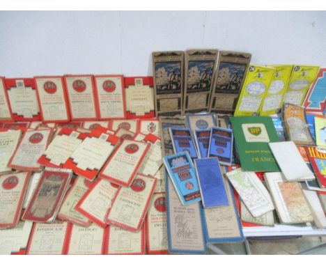
A large quantity of pocket and O.S maps, including, Bacon;s Environs of London, N.E; Reynolds, Shilling coloured map of the environs of London; Surrey sheet XLV.NW. second edition, 1898: Kelly's Post Office Directory map of London and many more of London, Surrey and the South East of England

Lot 3134
Nouveau Guide du voyageur en Italie, Milan, Suttgarde, 1829, folding hand-coloured map frontispiece, numerous folding maps and plans, together with Massey, Montague, Recollections of Calcutta for over Half a Century, Thacker, Spink & Co. Calcutta, 1918. Hardcover.1st Edition. In aid of the Red Cross Fund

Lot 3111
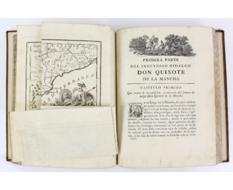
Cervantes Servantes Saavedra, MIGUEL DE El Ingenioso Hidalgo Don Quixote de la Mancha … Nueva Edicion corrigida por la Real Academia Española. Madrid: Por Don Joaquin Ibarra Impresor de Cámera de S. M. y de la Real Academia, 1780 4 volumes, 4to (11 7/8 x 8 3/4 in.; 302 x 222 mm). 4 engraved additional titles after Antonio Carnicero by Fernando Selma, engraved portrait of the author, 31 engraved plates after Barranco, Brunette, Carnicero, Del Castillo, Ferro, and Gil by Ballester, Barcelon, Fabregat, Gil, Mol, Muntaner, Salvador y Carmona, and Selam, folding engraved map with Don Quixote's journeys outlined in red, engraved initials and head- and tailpiece


Lot 431
Spain: After Blaeu (family), UTRUSQUE CASTILAE nova descriptio, a mid 17thC map of Castille, Spain, another map verso, hand coloured, image size 16in x 19¾in (41cm x 50cm), good condition, together with three mid 17thC other maps of Spain 'LEGIONIS REGNUM et ASTURIARUM PRINCIPATUS', 'GRANATA et MURCIA REGNUM', and 'ANDALUZIA continens SEVILLAM et CORDUBAM', hand coloured, image size 14¾in x 19¼in (37.5cm x 49cm), all in poor condition, glazed and framed and 'Baleu's Atlas, England, Scotland, Wales and Ireland', published by Thames and Hudson, undated, c.1970, folio, in red half leather over grey cloth boards, a numbered facsimile edition 483 / 500 of maps originally published by John Blaeu in 1645 and 1654 with an introduction by R.V. Tooley, in grey slip case (5)
![Scotland: Gordon (Robert) SCOTIA ANTIQUA: MAP OF SCOTLAND [Amsterdam: Blaeu,] a mid 17thC engraved Map of Scotland, hand colo](https://cdn.globalauctionplatform.com/6c34858d-4217-4a0d-a6e0-ac6a009ea62d/6712c32b-f626-4745-a2bf-ac8d012d5645/468x382.jpg)
Lot 432
Scotland: Gordon (Robert) SCOTIA ANTIQUA: MAP OF SCOTLAND [Amsterdam: Blaeu,] a mid 17thC engraved Map of Scotland, hand coloured, image size 16½in x 21½in (42cm x 54.5cm), paper does not lie flat, yellowed and faded, glazed and framed, together with two other antique maps of Scotland: 'A New & Correct MAP of the NORTH PART of SCOTLAND, from the best AUTHORITIES', Engraved by J. Carey, in a card mount, and 'PRESENT SCOTLAND', glazed and framed, together with Scotland: Hole (William), Scotia Regnum, an early 17thC engraved topgraphical Map of Scotland, hand coloured, image size 10¼in x 12¼in (26cm x 31cm), faded along central fold, overall yellowed, glazed and framed, together with 'A MAP OF THE KINGDOM OF SCOTLAND from the latest and best Observations For Mr Tindal's Continuation of Mr Rapin's History' (5)

Lot 433
Shropshire: Morden (Robert), Shropshire by Robert Morden sold by Abel Swale Awnsham & John Churchil, a late 17thC engraved Map, hand coloured, image size 14in x 16½in (35.5cm x 42cm), good condition, together with a similar map: Worcestershire by Rob.t Morden sold by Abel Swale Awnsham & John Churchil, and another Map, 'Worcestershire from the best Authorities', engraved by J. Carey, all three glazed and framed, Yorkshire: Blaeu (Johannes), Ducatus Eboracensis pars Occidentalis The West Riding of Yorkshire, a mid 17thC engraved map of The West Riding of Yorkshire, hand coloured, image size 16¼in x 19¾in (41.5cm x 50cm) and English Counties: twelve various antiquarian Maps, including a 19thC Birmingham Street Map, A New Map of Northamptonshire from the best Authorities, The Road from Chester to Cardiff in Glamorganshire, Herefordshire, Buckinghamshire, Bedfordshire, Isle of Wight, Cheshire, etc. all framed and glazed (16)


![[Map] Chart of the North-West Passage Discovered by Capt McClure, HMS Investigator, 1850 - 1853, from the charts prepared by](https://cdn.globalauctionplatform.com/91e32445-9c00-4f32-a784-ac8500a609cb/897c48d5-2e16-4087-9f64-ac8800f2dd53/468x382.jpg)


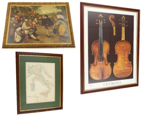
Lot 2148
After Breugel - seated gentleman with codpiece playing bagpipes with villagers dancing in a street with thatched houses, framed coloured print, 21" x 29"; also a framed coloured print of Antonio Stradivari: 'Violino II Cremonese 1715' ex Joachim-Palazzo Comunale and a framed coloured map of Italy (3)


Lot 41
Sir Frank Bowling OBE RA (British, b.1934). 'Ace of Spades'. Acrylic / collage on Paper, signed and dated verso. 30 x 21.7cm. Frank Bowling has been hailed as one of the finest British artists of his generation. Born in British Guiana in 1934, Bowling arrived in London in 1953, graduating from the Royal College of Art with the silver medal for painting in 1962. By the early 1960s, he was recognised as an original force in London’s art scene with a style combining figurative, symbolic and abstract elements.After moving to New York in 1966, Bowling’s commitment to modernism meant he was increasingly focused on material, process and colour, so that by 1971 he had abandoned the use of figurative imagery. Bowling’s iconic ‘Map Paintings’ (1967-71), which include the stencilled landmasses of South America, Africa and Australia, embody his transition from figuration to pure abstraction. As a contributing editor at Arts Magazine (1969-1972), Bowling rejected the idea that ‘artists who happen to be black’ should be making overtly political or protest art and defended those engaged in abstraction. His critical writings represent a significant contribution to intellectual debates on ‘black art’. In 1969, Bowling organised, curated, and wrote the catalogue essay for the notable exhibition, 5+1, at the State University of New York, Stony Brook, and Princeton University, which showcased the work of five African American abstract artists as well as his own recent paintings. Bowling exhibited six large ‘Map Paintings’ in a solo show at the Whitney Museum of American Art in 1971. From 1973 to 1978, Bowling experimented with ideas of chance and ‘controlled accidents’, pouring paint from a two-metre height to create his visually arresting ‘Poured Paintings’.Bowling returned to London in 1975 but continued to spend significant periods in New York. His sculptural paintings of the 1980s include embedded objects and thickly textured canvases, and have been described as evoking landscape, riverbeds and geologic strata. Visible in his work, are legacies of both the English landscape tradition and American abstraction. Bowling shares Turner and Constable’s preoccupation with light, never more evident than in his dazzling ‘Great Thames’ paintings of the late 1980s. Bowling’s experiments with ammonia, gel, metallic and pearlescent paint create incandescent reactions on the canvas. His recent work encompasses collage, poured paint, stencilling, staining, and stitching canvases, bringing together techniques honed over a lifetime of painting.Bowling became a Royal Academician in 2005 and was awarded the OBE for services to Art in 2008. His work is represented in fifty collections worldwide and has been exhibited in 160 group and 100 solo exhibitions, including the 2017-19 touring exhibition, Mappa Mundi, and the hugely successful retrospective at Tate Britain in 2019. Bowling is the subject of a BBC documentary, Frank Bowling's Abstract World, which coincided with the opening of the Tate Retrospective. At the age of 86, Bowling works every day in his South London studio, accompanied by his wife, Rachel, other family members and friends, forever driven by his fascination with pushing the vast and radiant possibilities of paint.Transplant Links Community is a UK registered non-religious and non-political charity that saves the lives of children and adults in the developing world who suffer from life-threatening end stage kidney disease. Offering teaching and advice, and carrying out living kidney transplants, sharing their knowledge with local medical teams in a variety of countries - so that sustainable transplant programmes become a possibility for the future. Please note that there is no buyers premium payable on this sale if bidding on Ewbank's Live, online fee of 6% inc VAT is payable bidding via the-saleroom.com. Added to the hammer price. Ewbank's are also waiving all vendor commission for the charity.
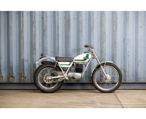
Lot 532
c.1975 Ossa 244cc MAR Trials MotorcycleRegistration no. not UK registeredFrame no. B231133Engine no. M-231133Founded in 1951, the Spanish firm of Ossa first achieved worldwide recognition when works rider Santiago Herrero came close to winning the 250cc World Championship in 1969. Nevertheless, the off-road market was by far the more important for Ossa, as it was for local rivals Bultaco and Montesa. In a bid to emulate the latter's competition successes, Ossa hired English trials star Mick Andrews in 1967. Then only 23 but already a proven winner, Andrews set about developing Ossa's existing trail bike into a competitive trials mount, a process that culminated in the MAR - Mick Andrews Replica - that carried its creator to consecutive European Trials Championships in 1971 and '72. The MAR put Ossa on the trials map with a vengeance and proved so successful that it remained in production until the late 1970s. We are advised by the current vendor that this particular MAR had been treated to a 'last nut and bolt' restoration by the previous owner in Kent prior to its purchase by him in July 2019. A potentially competitive mount in 'Twin-Shock' trials, this attractive machine would respond well to careful detailing. There are no documents with this Lot.Footnotes:As with all Lots in the Sale, this Lot is sold 'as is/where is' and Bidders must satisfy themselves as to the provenance, condition, age, completeness, and originality prior to bidding.For further information on this lot please visit Bonhams.com
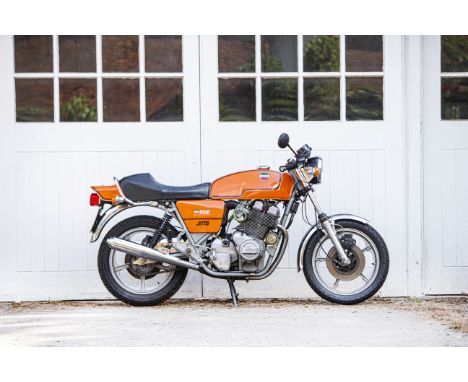
Lot 555
Property of a deceased's estate 1981 Laverda 981cc Jota '180'Registration no. HAY 80VFrame no. LAV1000-6365Engine no. 1000-6365Blessed with one of the most evocative names in motorcycling history, the Slater Brothers-developed Jota was the bike that really put Laverda on the map. Few major changes were made to the three-cylinder Jota prior to 1982 when a heavily revised version was introduced, complete with a 120-degree crankshaft that made for a more even firing order. One consequence of this was the instant elevation of the original version, which came with a 180-degree 'flat' crank, to iconic 'first-of-the-line' status among collectors. This Jota '180' was purchased by its late owner from Slater Laverda on 5th August 1997 at 23,037 miles (correspondence, MoT certificate, and sales invoice on file). Issued 12 months later, the next MoT certificate records the mileage as 23,221, while the current odometer reading is 23,224 miles. The tax disc in the holder expired on 31st August 1999 and it is believed the Jota has not been ridden since then. On file is a page of hand-written notes detailing various cleaning and servicing tasks undertaken in 2018/2019, while the final entry is dated January 2020. Additional paperwork consists of sundry bills and old/current V5/V5C documents. Unused for some considerable time, the machine will require recommissioning or restoration to a greater or lesser extent and is sold strictly as viewed. Accordingly, prospective bidders must satisfy themselves as to the condition and completeness prior to bidding. A (copy) workshop manual is included in the sale. Footnotes:As with all Lots in the Sale, this Lot is sold 'as is/where is' and Bidders must satisfy themselves as to the provenance, condition, age, completeness, and originality prior to bidding.For further information on this lot please visit Bonhams.com

Lot 23
JOHANN GABRIEL DOPPELMAYR 1677 - 1750: GLOBUS COELESTIS NOVUS 1728 Wood, brass, paper 47 x 51 cm Signed: In the cartouche "Ioh. Gabr. Doppelmaieri M.P.P." Baroque table star globe by I.G. Doppelmayer according to the map of the starry sky by Johann Hevelius. The globe consists of twelve carved wedges with pasted on hand-painted engravings on paper. It is set in a four-legged base with an octagonal wooden horizon and brass meridians. The equivalent piece is located in the National Library of the Czech Republic.


-
109182 item(s)/page