We found 109182 price guide item(s) matching your search
There are 109182 lots that match your search criteria. Subscribe now to get instant access to the full price guide service.
Click here to subscribe- List
- Grid
-
109182 item(s)/page


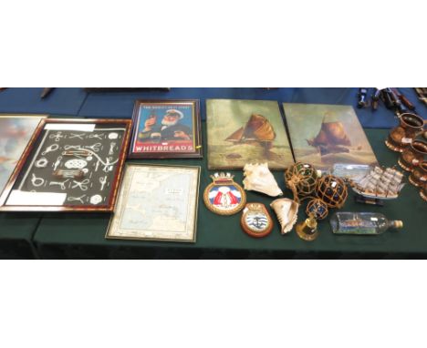
Lot 147
A mixed lot of posters Indians of the North American plains, printed by Sunday Times special projects unit, 1974 The Vikings, printed by Sunday Times special projects unit, 1980 International dial code map, printed by Grapple Group London Print of ‘full sail’ by Michael Beddows (x2) Poster of Ben Murphy from alias Smith & Jones, published by Pace International, Romford, 1972 Poster of Coleman’s mustard polar bear (probably reproduction) Periodic table Magna Carta: Translation & facsimile published by H.M stationary office 1965 (unopened) The Spinners in concert, Odeon Theatre Lincoln, charity concert, printed by Hastings printing co. Status Quo poster Kings & queens poster Ruston offshore – Europe, printed by Ruston Kings & Queens chart printed by Department of the Environment/H.M. Stationary office, 1967 Dead men’s treasure, museum of nautical art, Penzance (x2) Ogri ten commandments, Ogri products Ogri unlikely record breakers, Ogri products Mike Hailwood poster The festival year poster, the festival shop Ltd, printed by Bennett & Meryl, 1995 3x reproduction 18th century Royal Navy posters June 1919 Alcock & Brown fly Atlantic non-stop poster, printed by postal publicity branch, GPO November 1919, first flight England-Australia Smith Brothers, printed by postal publicity branch, GPO Steam ships poster, printed by postal publicity branch, GPO Lincolnshire Echo poster of England World Cup squad for Spain 1982 Judo, karate, aikido poster, printed by J.Milom Ltd, Manchester 4x martial art posters, printed by J.Milom Ltd, Manchester Main techniques of judo poster, printed by J.Milom Ltd Our woodland friends thee badger, printed by Naylor Clayware The age of dinosaurs printed by Sunday Times Special projects Unit, 1973


Lot 701
WW1 Zeppelin trench art including a pennant made in the form of a cross engraved Zepp l33 24-9-16 a ring engraved Zeppelin l31 1916 and a section of wire from the Cuffley Zeppelin Sept 3rd 1916 in Red Cross presentation packet also comes with a 1920 map of the zeppelin airship rain 25-26th September 1916


Lot 619
Turner (Samuel) An Account Of An Embassy, To The Court Of The Teshoo Lama In Tibet, second edition, London 1806, half calf Condition report Report by GH Map does not appear to be present. Other plates are however. I can confirm that there are 13 plates. There is no large fold out map, and there are 473 pages. In terms of condition, plates and pages are generally clean with occasional small amounts of foxing predominantly round the edges of the plates rather than in the middle. The volume has been rebound, but the binding does appear to have some age, so it is not a recent rebinding. Binding bumped and leather scuffed in places.


Lot 299
A collection of unused British Rail Southern Region Reserved Seat tickets / cards along with staff brochures to include Working instructions for Class 253 and Class 253 trains along with a Route Map Wootton Bassett to Reading, Your personal safety operating and motive power, British Railways ( Western Region ) Multiple unit diesel trains for the information of operating department staff.


![JOHN SPEEDE; an 18th century and later hand coloured engraved map of "The Countye [sic] Palatine of Chester", with inset view](https://cdn.globalauctionplatform.com/4c9bbf7e-9ad4-429e-bd6a-a58a012b57af/2daaa21c-e6db-4e6b-e9c8-7c04eefb09da/468x382.jpg)


Lot 1301
HAGGERSTON CASTLE ESTATE, Beal, Northumberland . . . illustrated particulars of sale . . . 14 photo. views, large coloured & folded map & folded plan; printed wrappers, folio, 1930. * the sale having failed to find a buyer the (palatial) mansion house was demolished in 1933; sold with another copy


Lot 1401
WEST (T.) The Antiquities of Furness. new edition with additions by William Close. engraved map, plan & 5 plates, subscriber's list; old half calf & marbled boards. Ulverston, 1805; HOUSMAN (J.) A Descriptive Tour, and Guide to the Lakes . . . in Cumberland, Westmoreland . . . 2nd edition, embellished with several additional plates. 3 folded maps & 6 plates; old cloth. Carlisle, 1802; sold with 3 other antiquarian 'Lakes' titles. (6)

Lot 1477
Emanuel BOWEN - An Accurate Map of the County of Kent. Divided into its Lathes . . . hand-coloured, 55 x 72cms. attractive pictorial title & dedicatory cartouches, inset of Thanet to the South Foreland & Goodwin Sands; extensive engraved text in surrounds - historical extracts, produce, manufactures, etc. printed for John Tinney . . . John Bowles . . . & Robert Sayer . . . (1760). * from Bowen & Kitchin's The Large English Atlas. Illustrated

Lot 1334
OWEN (John) Britannia Depicta . . . being a Correct Coppy of Mr. Ogilby's Actual Survey of all ye Direct & Principal Cross Roads in England and Wales . . . engraved title within a decorated & pictorial border, 4pp. engraved tables, an engraved & hand-coloured folded map (by Moll) & 213pp. of road maps (by Emmanuel Bowen); old reversed calf, cr. 8vo. printed for, & sold by Tho: Bowles . . . 1720. * most pages with 3 or 4 columns of strip maps (titles within decorative cartouche) interspersed with miniature county maps, armorials & an engraved text - with historical & directory information. Illustrated
![[HAKLUYT, R. The Principall Navigations, Voiages and Discoveries of the English Nation . . . ] lacks title & map (as usua](https://cdn.globalauctionplatform.com/01a8435d-5476-4318-a514-a58700b5f5c5/1fe9455b-8fa1-4ca4-de7c-f2038531bd4f/468x382.jpg)
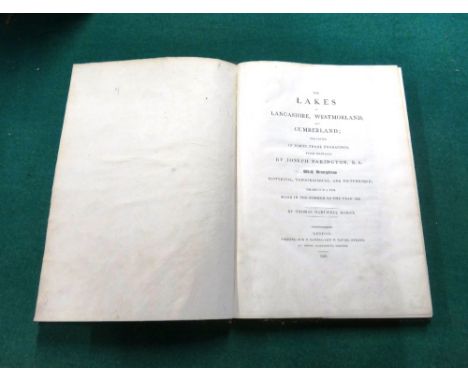
Lot 1400
HORNE (T.H.) The Lakes of Lancashire, Westmoreland, and Cumberland . . . the result of a tour . . . First Edition. 43 copper-engraved plates (by Joseph Farington) & a double-page coloured map; contemp. half morocco & marbled boards, gilt-panelled spine, marbled e/ps. & edges, roy. 4to. 1816.
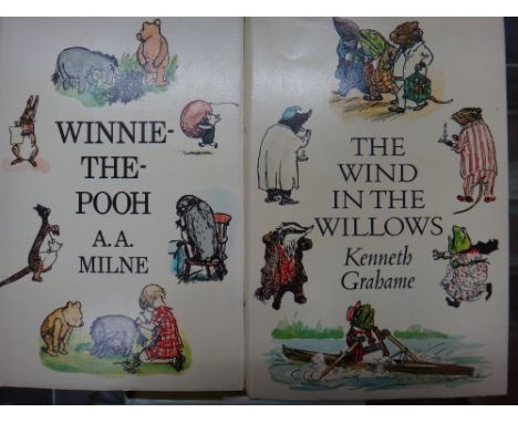
Lot 1446
MILNE (A.A.) Winnie-the-Pooh. First Edition thus. coloured illus. & e/ps. map (by E.H. Shepard); gilt-pictorial cloth & d/wrapper. 1973; sold with The World of Pooh . . . illus. (some coloured), d/wrapper. reprinted, 1973. * both signed on title by illustrator (May 1974); and GRAHAME (K.) The Wind in the Willows. First Edition thus. coloured illus. & e/ps. map (by E.H. Shepard), d/wrapper. 1971. * signed on title by above.

Lot 1459
KENT - A Map of the Hundred of Axstane / A Map of the Hundred of Little and Lesnes / A Map of the Hundred of Blackheath. hand-coloured, 37 x 37cms. from the second (Canterbury) edition of Hasted's History of Kent (1797-1801). * detailed maps, scale almost 2ins. to mile, includes lanes, num. properties named (etc.); sold with 4 area sheets from Andrews Dury & Herbert's 'A Topographical Map of the County of Kent (1769). hand-coloured, approx. 45 x 66cms. * v. detailed, incl. inlets, streams & mills (etc.) (7)


Lot 57
A framed engraving, 'A View of the Long Room and Baths with the Country adjacent, near Plymouth', 'James Northcote delin.t, J. Mason Sculp.t', 29 x 43cm, after John Speed 'Devonshire with Excester Described and the armes of such nobles......', a framed map, 37.5 x 50.5cm, an unframed engraving after JMW Turner, 'Source of the Tamar & Torridge' and one other, (4).


Lot 430
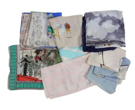
Promotional scarves, a BOAC Comet silk scarf, all circa 1960, centred picture of the plane within a border depicting motifs of different countries; two depicting vignettes of European stamps; two including Scenes of London; one with a map London; a 'Drive Safely' silk scarf depicting comic scenes; and three others

Lot 164
A hand tinted map of the county of Lancaster by Eman Bowen (1694-1767) Map showing all the towns and villages of Lancashire, dedicated to the right honourable Edward Stanley Earl of Derby, 70x53cm, framed and glazed, map of the county of Palatine of Lancaster made in the year 1818 by C & J Greenwood, collected and published February 24th 1830, 64x70cm, framed and glazed, facsimile copy of William Yates map of Lancashire originally dated 1786. (3)


-
109182 item(s)/page