

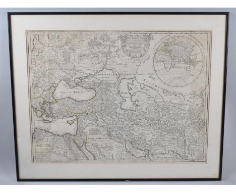
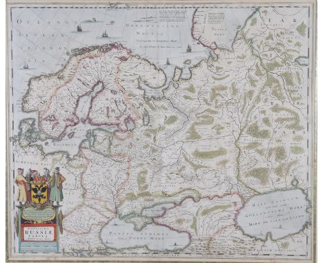
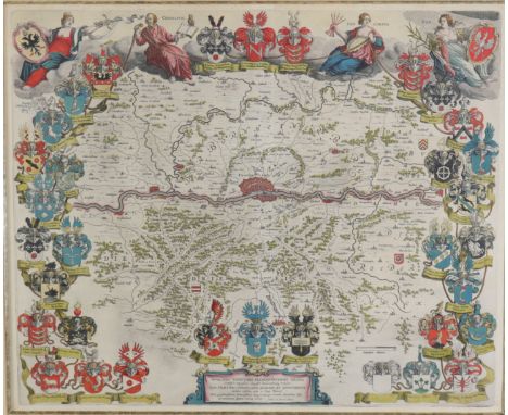
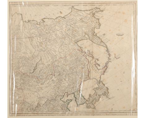
"AUSTRIAN POLAND", map belonging to the "Atlas Universel, dressé sur les meilleures cartes modernes", second half of the 18th century.Illuminated engraving (color demarcations).Edition M. Remondini, Venice, 1784.Hand-numbered on the reverse (no. 47), corresponding to the numbering stipulated in the index.The lot is accompanied by a copy of the title page of the Atlas.Measurements: 46 x 60 cm (print); 53 x 76 cm (paper).This map of Austrian Poland also contains part of Red Russia and the southern part of the Kraków Palatinate.The origin of the "Atlas Universel, dressé sur les meilleures cartes modernes" (Universal Atlas made from the best modern maps) dates back to 1757, when Gilles Robert de Vaugondy (1668-1766) and his son Didier Robert de Vaugondy (1723-1786), geographers to the King of France, formed one of the most renowned map and globe making workshops in France. The excellent position of the Vaugondys in the field of topography, added to the family ties that united them with Nicolas Sanson, one of the most important cartographers of the 17th century, led the Vaugondys to inherit much of the cartographic material that the latter had accumulated over the years, leading to the birth of the ambitious and unique Universal Atlas of which our map is a part. The copy became a commercial and cartographic success with enormous influence in all Europe, reason why the brothers Paolo and Francesco Santini, Venetian engravers, did not let escape the opportunity to acquire the original plates to the Vaugondy. Thus, in 1776, the Santini brothers commissioned the production of new copper plates, while substantially maintaining the original design, keeping the toponyms and the inscriptions in French as defined in the 1757 copy. Due to their knowledge of the Italian territory, the Santini's changes mainly affected the maps of the Italian regions. The following year, Paolo Santini ceded all his publication rights to M. Remondini, who in 1777 and 1784 republished the same Atlas, but with his name.The copy of which our map is part, edited in 1784 by M. Remondini, maintains the exceptionality of the original work of the Vaugondy: the meticulous treatment of the information (based on the revision of the oldest maps available, buying them with the most updated material at the time); the incorporation of the latest academic research in force at the time; the integration of their own astronomical observations (correcting if necessary even the latitude and longitude) or the great decorativism of each of their maps. As in the great majority of cartographic documents produced in France during the 18th century, the map in question is characterized by its enormous pictorial value and great attention to detail.Antique maps are one of the most complete documentary typologies. Their double nature, cartographic and historical, attracts the attention of the most demanding collectors, who see in cartography the faithful reflection of the past, betting on its purchase and its diffusion in the art market. The rarity of some of the editions, added to the longevity of many of the specimens, make the possession and enjoyment of antique cartography an increasingly fashionable pleasure among art lovers. Understood as authentic reminiscences of the past, antique maps become a conscientious reflection of how the territory was divided long ago, or how geographical features define our world. Their decorative character, added to the meticulous and ambitious work of cartographers, turn these pieces into authentic works of art.
We found 109182 price guide item(s) matching your search
There are 109182 lots that match your search criteria. Subscribe now to get instant access to the full price guide service.
Click here to subscribe- List
- Grid
-
109182 item(s)/page

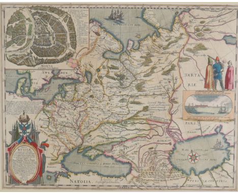
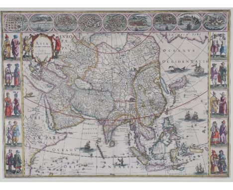
"CIRCLE OF BAVARIA", map belonging to the "Atlas Universel, dressé sur les meilleures cartes modernes", second half of the 18th century.Illuminated engraving (color demarcations).Edition M. Remondini, Venice, 1784.Hand-numbered on the reverse (no. 33), corresponding to the numbering stipulated in the index.The lot is accompanied by a copy of the title page of the Atlas.Measurements: 49.5 x 54.5 cm (print); 53 x 76 cm (paper).Map of the circle of Bavaria including the Upper Palatinate, the duchies of Upper and Lower Bavaria and Neuburg, the archbishopric of Salzburg, the archbishoprics of Regensburg, Freisingen and Passau and the provostship of Berchtolsgaden. The Bavarian Circle was an Imperial Circle of the Holy Roman Empire.The origin of the "Atlas Universel, dressé sur les meilleures cartes modernes" (Universal Atlas made from the best modern maps) dates back to 1757, when Gilles Robert de Vaugondy (1668-1766) and his son Didier Robert de Vaugondy (1723-1786), geographers to the King of France, formed one of the most renowned map and globe making and manufacturing workshops in France. The excellent position of the Vaugondys in the field of topography, added to the family ties that united them with Nicolas Sanson, one of the most important cartographers of the 17th century, led the Vaugondys to inherit much of the cartographic material that the latter had accumulated over the years, leading to the birth of the ambitious and unique Universal Atlas of which our map is a part. The copy became a commercial and cartographic success with enormous influence in all Europe, reason why the brothers Paolo and Francesco Santini, Venetian engravers, did not let escape the opportunity to acquire the original plates to the Vaugondy. Thus, in 1776, the Santini brothers commissioned the production of new copper plates, while substantially maintaining the original design, keeping the toponyms and the inscriptions in French as defined in the 1757 copy. Due to their knowledge of the Italian territory, the Santini's changes mainly affected the maps of the Italian regions. The following year, Paolo Santini ceded all his publication rights to M. Remondini, who in 1777 and 1784 republished the same Atlas, but with his name.The copy of which our map is part, edited in 1784 by M. Remondini, maintains the exceptionality of the original work of the Vaugondy: the meticulous treatment of the information (based on the revision of the oldest maps available, buying them with the most updated material at the time); the incorporation of the latest academic research in force at the time; the integration of their own astronomical observations (correcting if necessary even the latitude and longitude) or the great decorativism of each of their maps. As in the great majority of cartographic documents produced in France during the 18th century, the map in question is characterized by its enormous pictorial value and great attention to detail.Antique maps are one of the most complete documentary typologies. Their double nature, cartographic and historical, attracts the attention of the most demanding collectors, who see in cartography the faithful reflection of the past, betting on its purchase and its diffusion in the art market. The rarity of some of the editions, added to the longevity of many of the specimens, make the possession and enjoyment of antique cartography an increasingly fashionable pleasure among art lovers. Understood as authentic reminiscences of the past, antique maps become a conscientious reflection of how the territory was divided long ago, or how geographical features define our world. Their decorative character, added to the meticulous and ambitious work of cartographers, turn these pieces into authentic works of art.


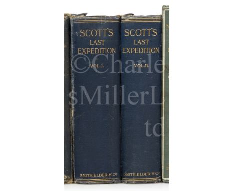
'SCOTT'S LAST EXPEDITION' by Capt R.F. Scott & Dr. E.A. Wilson, two vol, first edition, photogravure portrait frontispiece, large folding map at end of vol. I, numerous plates including six photogravure sketches by Wilson, a few folding plans and maps, original blue cloth, uncut, hinges a little rubbed, large 8vo, London, Smith, Elder & Co., 1913 (2)Footnote: Vol. I contains Scott's journals and vol. II 'Being the Reports of the Journeys & the Scientific Work undertaken by Dr E.A. Wilson and the Surviving Members of the Expedition'. The preface is by Sir Clements R. Markham.
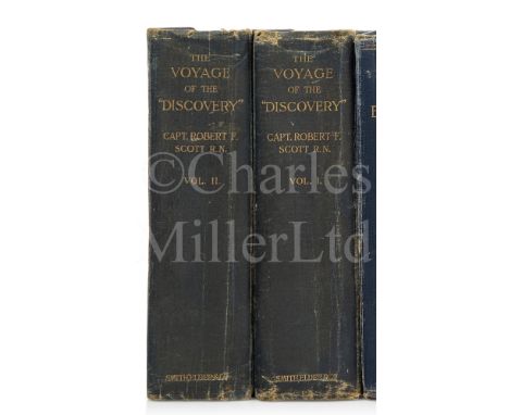
'THE VOYAGE OF THE DISCOVERY' by Captain Robert Falcon Scott, two vol, first edition, photogravure frontispiece, that in vol. II a portrait of Scott, folding map in a pocket at end of vol. I (lacking in vol. II), numerous plates (many detached), some foxing and spotting, original blue cloth, gilt decoration on front covers, very rubbed, inner hinges broken, 8vo, London, Smith, Elder & Co., 1905; and a copy of vol. II with the map in the pocket at end (2) Sold not subject to return
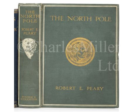
'THE NORTH POLE' by Robert E. Peary, first edition, photogravure portrait of the author, large folding colour map at end and 116 plates, original pictorial cloth, central gilt medallion portrait of Peary, 4to, London, Hodder and Stoughton, 1910Footnote: With an extremely congratulatory introduction by President Theodore Roosevelt.
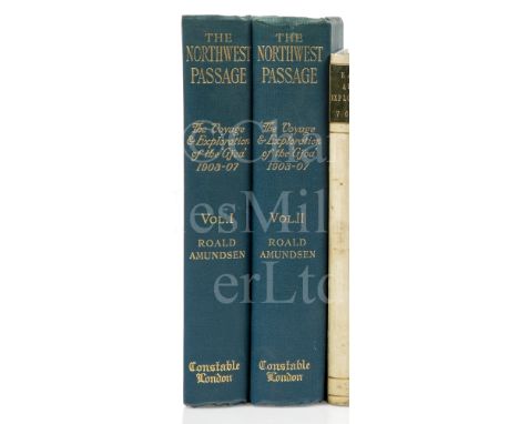
'THE NORTHWEST PASSAGE, BEING THE RECORD OF A JOURNEY OF EXPLORATION OF THE SHIP GJOA 1903-07' by Roald Amundsen, two vol., first English edition, photogravure frontispieces, that of vol. I a portrait of the author, folding map in a pocket at end of both vol., plates, original blue cloth gilt, t.e.g., partly unopened, large 8vo, London, Archibald Constable, 1908 (2)Condition report: A fine copy.


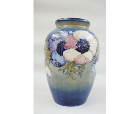
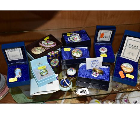
Moorcroft pottery vase, baluster form, light blue ground, anemone pattern, marked to base, with provenance 26cm highWith email:'Charles Henry Reeve was responsible for organising British Industries Trade Fairs in the early mid 1900s. He was clearing up at the end of one of these fairs, removing pin flags from a map, which showed where exhibitors/products were from. (These pins are still in the vase). He was having trouble holding these pins and had them in his cupped hands. Charles was near Moorcroft's stand, and Mr. Moorcroft gave him the vase off his stand to put the flags in.'Condition ReportNothing obvious to report


Quantity (approx 300 items) of London Transport ephemera, mainly 1950s onwards, comprising 90+ POCKET MAPS (Bus (one is 1913 LGOC), Underground etc) & 50+ pocket map AMENDMENT LEAFLETS, 120+ ROUTE ALTERATION TIMETABLE LEAFLETS plus 30+ sundry other LEAFLETS, a 1951 quad-royal POSTER MAP of Central London (folded) a FARE CHART, handful of photos etc. Condition ranges from well-used to very good, most are good to very good. [c300 items]
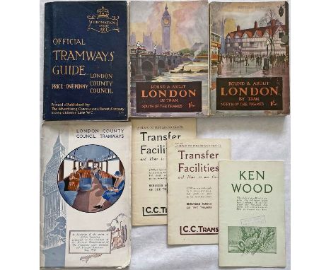
Selection (7) of 1910s-1930s LCC Tramways printed material comprising 1911 'Coronation Issue' Official Tramways GUIDEBOOK with fold-out system map, 1927/28 'Round & About London' GUIDEBOOKS (North and South of the Thames editions), both including the contemporary pocket maps, 1929 BROCHURES for Transfer Facilities (North and South of the Thames editions), 1920s BROCHURE 'Ken Wood' and 1932 illustrated BOOKLET 'A Description of the system of LCC Tramways'. All are in good to very good condition. [7]

Selection (8) of 1920s/30s bus & coach etc GUIDES & MAP (1) comprising 1936 Associated Motorways, 1930s Cumberland Motors Services Official Handbook, 1932 Edinburgh Corporation Official Guide, May 1930s Highways Guide, 1930s Manchester Map of Bus & Tram Routes, 1921 MacBrayne Summer Tours in the Western Highlands & Islands of Scotland, Winter 1930 Roadway Guide and c1930 Sheffield Corporation Tramways & Motors 'Pleasure Trips and Rambles. All in good to very good condition. [8]
-
109182 item(s)/page