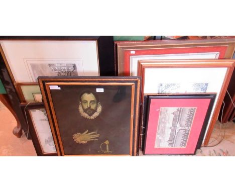
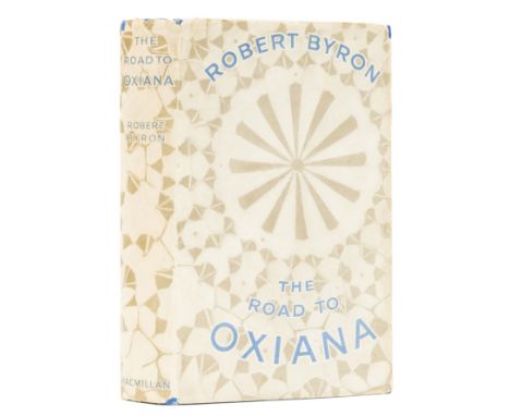
Byron (Robert) The Road to Oxiana, first edition, frontispiece, map and 15 plates, original cloth, spine very slightly faded, dust-jacket, spine ends and corners a little chipped with sympathetic minor restoration and strengthening, rubbing to extremities, in effect an excellent copy, 8vo, 1937.⁂ An attractive example of Byron's classic travelogue, difficult to find in good condition.
We found 109198 price guide item(s) matching your search
There are 109198 lots that match your search criteria. Subscribe now to get instant access to the full price guide service.
Click here to subscribe- List
- Grid
-
109198 item(s)/page
Tolkien (J.R.R.) The Hobbit, or There and Back Again, first edition, first impression, frontispiece, one plate and 8 illustrations, including 7 full-page, map endpapers printed in red and black, all by the author, 2pp. advertisements, occasional scattered spotting, original pictorial cloth, slight shelf-lean, very minor bumping to corners, else fine, first state dust-jacket with the misprint "Dodgeson" for "Dodgson" corrected by hand on rear flap, light spotting and horizontal mark to spine, light toning to extreme head and foot of flaps, light scuffing and creasing to corners, some very minor surface soiling, but a sharp, near-fine example overall, 8vo, 1937.⁂ A superb copy of Tolkien's landmark work.
Tolkien (J.R.R.).- Printed programme for the New College School production of The Hobbit, adapted by Humphrey Carpenter with music by Paul Drayton, 4pp., illustrations, with map by Drayton to final p., signed by Tolkien on upper cover, minor creasing, some light toning to margins of upper cover, [Hammond pp.23-24], 4to, 1967.⁂ A rare signed playbill for the second theatrical adaptation of The Hobbit.The first production of The Hobbit was performed at St. Margaret's School, Edinburgh for teachers and parents in 1953. This second production was a larger affair, performed over three nights, with the author in attendance on the final night. The play was adapted by Humphrey Carpenter and music composed by the school music teacher Paul Drayton (who also drew the map for the lower cover). Signed copies of the book were raffled off each night, Tolkien also signed copies of the programme for the performers.
Polar.- Rae (John) Narrative of an Expedition to the Shores of the Arctic Sea in 1846 and 1847, first edition, 2 folding engraved maps hand-coloured in outline, without the 10pp. advertisements at end, maps foxed and offset onto facing leaves (including title), large map with short tear at edge (repaired), some other foxing, mostly at beginning and end, ex-library copy with ink stamp to title, verso of maps and one or two other leaves, contemporary half calf, later black roan label, a little rubbed, [Sabin 67428], 8vo, 1850.⁂ Rae was sent by the Hudson's Bay Company to survey the north coast of Canada. The work provides much information on the natives of the area and also lists the fauna and flora. On a later journey he discovered the fate of Sir John Franklin and his expedition.
Russia.- Chappe d'Auteroche (Jean, Abbé) A Journey into Siberia, made by order of the King of France, first English edition, folding hand-coloured engraved map, 9 engraved plates (mostly of costumes), rather soiled and browned (mainly text), light water-staining to foot of plate of thermometers, tear to Kk3 not affecting text, bookplate of Richmond Allen, contemporary tree calf, red roan label, rubbed, spine worn at head, 4to, for T.Jefferys, Geographer to the King, 1770.⁂ Chappe d'Auteroche was sent to Siberia to study the transit of Venus which was due in June 1761. On his return he published this account of the manners and customs of the native inhabitants.
Selection of WW2 British Military Equipment, consisting of a pair of 1938 dated British officers Binoculars stamped with makers details and “BINO PRISM No2 MK II X6 No 10899”, housed in 37 pattern webbing box with clear ink stamp date 1939 inside; 1937 pattern webbing belt and holster set with ammunition pouches; 1940 dated 37 pattern webbing ammunition pouch; 1944 dated 37 pattern webbing officers map case; Gas mask in canvas carry case and Bren Gun magazine (empty). All generally in good condition.
Selection of WW2 Period Manuals etc, including Small Arms Manual, Home Guard Proficiency, 1943 Hints on Map Reading Instruction, First Aid in Air Raids, 1941 Regulations for the Auxiliary Territorial Service, Journal of the Air Raid Protection Institute, Small Arms Training Anti-Tank Rifle 1942, plus others. Various conditions. (18 items)
Wallis, J.P.R. (ed).: 1- The Zambesi expedition of David Livingstone 1858-1863; in 2 volumes (Signed copies). Chatto & Windus, 1956. Complete with 2 folding maps and colour plates. (Oppenheimer Series, 9). Both volumes Signed by Wallis on title pages. Original red cloth gilt, t.e.g.; 2- The Zambesi Journal of James Stewart 1862-1863. Chatto & Windus, 1956. Complete with folding map and frontis portrait. (Oppenheimer Series, 6). Original red cloth gilt, t.e.g.; 3- The Barotseland Journal of James Stevenson-Hamilton 1898-1899 (Signed copy). Chatto & Windus, 1953. Complete with a frontis, 5 colour plates and a folding. (Oppenheimer Series, 7). Both volumes Signed by Wallis on title pages, also the front blank endpaper inscribed: To Bob, with all best wishes from Dora and Jack (Dora was his wife). Original red cloth gilt, t.e.g. (4)
Chauncy, Sir Henry: The Historical Antiquities of Hertfordshire; in Two Volumes. Bishops Stortford, J M Mullinger, 1826, 2nd edn. Complete with list of subscribers and 45 plates, including the frontis and large folding map. Cont. half leather; rubbed; folding map torn on folds (without loss). (2)
Jodocus Hondius, Dutch 1563-1612, The Countie Pallatine of Lancaster Described and Divided into Hundreds 1610, a hand coloured engraved map, published by John Speed and sold by Thomas Bassett Fleet Street, with title Cartouche, plan of Lancaster, eight medallion Portraits, two armorials and scale of miles, 38cm by 50cm
A WWI 1:20,000 map of Vaire Wood, Northern France dated 22/6/18 and 24/6/18 with hand annotated machine gun, trench mortar, heavy field gun and light field installations. The lot also includes an aerial photograph of Hamel Wood and Accroche Wood dated 25/6/18. This area was the location of The Battle of Hamel on 4 July 1918, shortly after the annotations were made
A George III framed map sampler after and original published by Laurie and Whittle 1797. Europe with parts of Africa and Asia within an acanthus border. Jane Spence, Yarm, 1816, 39cm x 43cm. Condition Report. To be used as a guide only. Some discolouration. Free from tears and repair. Heavy flaking to the frame.
-
109198 item(s)/page