We found 109182 price guide item(s) matching your search
There are 109182 lots that match your search criteria. Subscribe now to get instant access to the full price guide service.
Click here to subscribe- List
- Grid
-
109182 item(s)/page


Lot 17
Artist: Valerie Osment Design: Travels with Edward About the artist Valerie Osment is a professional visual artist based in Essex whose work has painting and illustration at its core. With a BA Hons in Graphic Design and Illustration, she exploits multiple media and visual art forms to create work in 2D or 3D form. About the design ‘Travel’s with Edward’ is inspired by Edward Stanfords ‘Library Map of London’ published in 1862 and recognised as the first accurate map of London ever produced. The design concept is based upon an artistic Victorian traveller who, arriving in London, has a copy in hand of Stanford’s newly published 1862 London map to help guide them across the city. Armed with their trusty sketchbook, they seek out various locations and famous destinations, recording their visit by creating paintings & sketches of the 1862 London landmarks, its sights, sounds and skyline discovered. As they go they ‘tear’ off’ the relevant map section to ‘stick’ on the page next to the image, adding an interesting historical fact scribed in fountain pen. The bus’ design shows a multiple of differently sized opened page antique-looking sketchbooks. Each portrays a section from Stanfords original 1862 map and an image relating to that location. On the front of the bus a fictional newspaper announces the ‘Stop Press’ news about this wonderful new map just published. The back of the bus displays the traveller’s sketchbook cover entitled ‘London Sketches A to Z, 1862’. Featured on the roof are further open sketchbook pages including one for the ‘Adelphi Theatre (providing the ‘A’) and another for London Zoo (for the ‘Z’) as well as a decorative poster-like piece that has a quote from the Royal Geographical Society who at that time hailed the map as ‘the most perfect map of London ever issued’. Location: Long Acre Trail: Around Westminster Dimensions: Length- 2.4m Width 0.5m Height- 0.95m

Lot 25
Artist: Rod Hunt Design: London Takes the Bus About the artist Rod Hunt is an award-winning London based illustrator who has built a reputation for retro tinged illustrations, detailed character filled landscapes and is also the artist behind the bestselling Where’s Stig? books for the BBC’s hit TV show Top Gear. About the design London Takes the Bus is inspired by the key bus routes on the central london map - it almost looks like the map is spelling the word ‘bus’ in route lines. Location: Victoria Street Trail: Around Westminster Dimensions: Length- 2.4m Width 0.5m Height- 0.95m

Lot 29
Artist: One Red Shoe Design: Tunnel Vision About the artist Fiona and Neil Osborne (One Red Shoe) have been designing and painting murals in Cheshire and nationwide for the last 12 years. Working in public spaces, businesses and private homes - producing a portfolio ranging from large, gable-end murals to painted and furnished theme rooms. "We always try to problem-solve creatively and paint our designs wonderfully". About the design In homage to the iconic Harry Beck map, we took the eleven letters of the Underground logo and stretched them into abstract versions of the eleven colour coded train lines. Each coloured line flows around the bus using the rules but not the route of the original map, eventually joining its own name. Rather than a plain, white background we painted the underground tiles to add another level to the theme. There is also a small, hidden item on the bus... Location: Cardinal Place Trail: Around Westminster Dimensions: Length- 2.4m Width 0.5m Height- 0.95m

Lot 33
Artist: Oliver Dean Design: Journey to Anywhere About the design The role of London as a major tourist destination along with the idea that a journey continues beyond the map (so to speak) is the inspiration for this design along with the comparative similarity between the angular designs of Thomas Heatherwick’s Routemaster and Harry Beck’s underground map. This resulted in a kind of colourful mash up of line, angle and direction. About the artist Oliver Dean is an illustrator, author and artist from Essex. He works across a wide spectrum of art projects including community groups, commercial and private commissions. Location: Victory Park Trail: Around Queen Elizabeth Olympic Park Dimensions: Length- 2.4m Width 0.5m Height- 0.95m


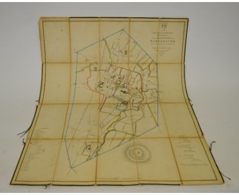
Lot 3
John Senex (1678-1740) "FRANCE COLLECTED FROM YE OBSERVATIONS MADE BY THE ROYAL ACADEMY OF SCIENCES AT PARIS" engraving with hand-colouring, published 1708 64.5 x 92.5cms; 25 1/2 x 36 1/4in. (plate size); together with an antique map "CARTE DE L'ENTREE DE LA TAMISE AVEC LES BUNES, PASSES OF ISLES ET COSTES COMPRISES ENTREE SANDWICH ET CLAY" engraving with hand-colouring, published by Jaques Nicholas Bellin 46 x 89cms; 18 x 35in. (plate size), unframed. (2)


Lot 8
John Cary (c.1754-1835) "A NEW MAP OF SOMERSETSHIRE DIVIDED INTO HUNDREDS..." engraving with hand-colouring, published 1805 52 x 57cms; 20 1/2 x 22 1/2in. (plate size); "A NEW MAP OF CAMBRIDGESHIRE DIVIDED INTO HUNDREDS..." engraving with hand-colouring, published 1806 59 x 51cms; 23 1/4 x 20in (plate size); together with other counties, publishing dates differ, all of similar sizes; and an engraved Carey title page, unframed. (23)

Lot 9
John Cary (c.1754-1835) "A NEW MAP OF HAMPSHIRE, DIVIDED INTO HUNDREDS...", "A NEW MAP OF SURREY..." AND "A NEW MAP OF DERBYSHIRE..." engravings with hand-colouring, published 1801 59.5 x 52cms; 23 1/2 x 20 1/2in. (plate size); together with twenty-one other Counties by John Cary, all of similar sizes, unframed. (24)


Lot 11
Giovanni Battista Sesti (Italian late 16th/17th Century) "PLANS OF CASTLE AND FORTIFICATIONS IN THE STATE OF MILAN" engravings c.1710 comprising 14 plans on 10 leaves, plus a map of the State of Milan, and a fold-out map of the Dutchy of Mantua (12 leaves in total enclosed by plain paper covers), unframed. See illustration


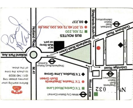
Lot 204
MCCARTNEY PAUL: (1942- ) British Musician, a member of The Beatles. Blue ink signature ('Paul McCartney') to the verso of a promotional postcard issued for a performance of Bread by Carla Lane at the BBC TV Studios in London. The verso bears the number 032 and is illustrated with a printed map and travel details to the television studio. Signed by McCartney with his name alone in blue ink to a clear area of one corner. Some light overall age wear and minor creasing (largely visible to the recto). About VG

Lot 382
DU MAURIER DAPHNE: (1907-1989) British Author. T.L.S., Daphne, six pages, 8vo, Menabilly, Par, Cornwall, 30th December 1967, to 'My dear' (Foy Quiller-Couch). Du Maurier writes a largely social letter to her friend following Christmas, thanking her for a large casserole tureen, 'which is being used this minute by Tessa and Flavia in the kitchen…to cook a Hot-Pot of turkey legs and veg mixed - the smells from the kitchen, and casserole, very good indeed' and further writing 'Our Christmas has been a good one, whether the last here or not I cannot foretell, it must surely depend on how long it takes to finish Kilmarth…I don't want to move from here until everything is ready. On the other hand neither do I want to have two ready-to-occupy houses on my hands, both needing to be heated. We shall see'. Du Maurier continues, referring to her work, 'I must now see how the turkey stew is brewing. Talking of brewing, I am turning my thoughts to a story about Tywardreath, the Priory, the Lord of the Manor, etc, in the fourteen hundreds (1330 approx) and am doing quite a bit of research on subject. Another Mr. Clampish type, a Mr. Thomas of Old Cornwall Society in Tywardreath, is being very helpful, and has lent me a glorious full scale tithe map of Tywardreath which is proving a boon. It gives the names of the old Priory lands, and all the fields, etc, and shows where the sea came to, and many other things, and I find it absorbing. What is very interesting is that the Carminow family of Carminow and Trelowarren before the days of the Vyvyans, were very connected with the manor of Tywardreath, and I am hoping to sort it all out. I am very intrigued by a young woman called Isolda who married Sir Oliver Carminow, as his second wife, and he seems to have had a clandestine marriage to a 3rd down in your Mawgan. Their estates were all down there, but a great finger in the Tywardreath pie. As to the Priory, it was full of dissolute monks from Angers, who kept on being reprimanded by the Bishop of Exeter. I wonder if your father ever felt himself drawn to that moment of time in local history, but I can't think, off-hand, of any book of his that dealt with it. Correct me if I am wrong. I have never studied it hitherto but am deep in it now. Period, Edward II, and then early Edward III and The Black Death'. She concludes with an amusing anecdote, 'You know the “mincy“ builder Mr Pascoe at Kilmarth. We discovered a well in the basement the other day, and I told him it had probably been shut up since the Black Death, and that he must get a ladder and go down it and see if skeletons reposed at the bottom. He was very disconcerted, and to distract my attention put a lot of flowers in pots in the front porch and bowls of bulbs'. A few small, minor tape stains at the head of some pages, only very slightly affecting one word of text, and not the signature, otherwise VG Foy Quiller-Couch - daughter of British writer Arthur Quiller-Couch (1863-1944), and a life-long friend of Du Maurier. Indeed, Du Maurier was accompanied by Foy Quiller-Couch when she became inspired with the storyline for her novel Jamaica Inn. Some years previously the two ladies were staying at Jamaica Inn and went riding on Bodmin Moor. They became lost in bad weather conditions and apparently sheltered for some time in a derelict cottage on the moor but were eventually led back to Jamaica Inn by their horses. The work to which Du Maurier refers to in the present letter is her novel The House on the Strand which was published in 1969. It is set in and around Kilmarth near the Cornish village of Tywardreath (which translates from the Cornish language as 'House on the Strand').


Lot 118
A Voyage to Abyssinia & Travels to the Interior of that Country in the year 1809 & 1810 by Henry Salt, published by Rivington 1814 - the book is bound in half leather with some wear but still holding. All plates are present but one map has been clumsily folded and has a closed tear. This is a seminal example of travel literature and quite scarce.


Lot 207
BRADFORD CITY Collection of programmes and booklets including "Putting Valley Parade On The map" booklet (1995), Bernard of the Bantams issue 1 Autumn 1988/89 booklet, programmes comprising Grenville Hair Testimonial v Leeds, Cup 59/60 v Everton, single card v All-Star XI 12/4/54, single sheet v Chesterfield 26/2/83, Bruce Stowell Testimonial v All Star XI 1969, v Doncaster and v Shef Utd both 88/9, both Yorkshire and Humberside Cup, v Blackpool 72/3 Cup, v Lincoln 84/5 (Fire Disaster) and aways at Brighton 58/9 Cup and at QPR 58/9. Minor faults. Generally good


Lot 285
A First World War commemorative napkin printed cotton, 'Its a Long Way to Tipperary', shown as a map of Great Britain and the coast of France, a uniformed soldier can on French section waving to three females positioned in the England, Ireland and Scottish regions, all in according costume, 13 x 12in. (33 x 30.5cm.).

Lot 408
An interesting late 17th / early 18th Century rent ledger, velum covered, the first page dated 1676, the last August 5th 1727 detailing rents and debts forgiven, 40 cm x 16 cm; an interesting George III Estate book relating to Grounds In The Parish Of Calverton In The County Of Nottingham...1779 with frontispiece "Act", the back with index of names and roads, tooled calf boards, 39 cm x 25 cm; an Ordnance Map of The Chilwell Estate Showing Property Comprised In The Portage to Mr Andrew Montagu's Trustees for £25.., the frontispiece with Estates Office Clifton, Nottingham letter, dated November 24, 1917; a George III rent book (4)


Lot 449
The Graphic Parliamentary Map, General Election 1892: Showing The members Returned For County Divisions And Boroughs...coloured lithograph, 80 cm x 57 cm and contained within oak frame with gilt slip Viscount Newark, Charles Pierrepont, 4th Earl Manvers was returned as Parliamentary Member for Newark

Lot 752
An English mid 13th Century sword with dished circular pommel, tight grip above shaped cross guard, the 81.5 cm blade with deep fuller, 40 cm long approx., 97 cm long overall, pommel 6.5 cm diameter, cross guard 18 cm wide; together with a map indicating the sword's find (the sword with later protective varnish) The sword was found in the Lincolnshire Wash off Holbeach St Matthew, Fosdyke Wash, Mare Tail, by a Mr Baines who worked for The Drainage Board, stationed at Pode Hole. It was discovered approximately 40 years ago at low tide, and purchased by the present vendor shortly thereafter from Mr Baines.

Lot 1919
County Palatine of Chester map by John Speede, late 17th Century Map showing the city of Chester, towns and villages, performed by John Speede assisted by William Smyth, sold by Thomas Bassett in Fleet Street and Richard Chiswell in St Paul's Churchyard, 40x52cm, verso printed description of The County Palatine of Chester, framed and glazed.

Lot 1930
William Kip, A map of Staffordiae Engraved and hand coloured, Staffordiae, Comitatvs Pars, Olim, Cornauiorum, 30x38cms, framed, another, Insvla Sacra'.-Vulgo Holy Island'et Farne, hand coloured with line and unicorn crest top right hand corner, framed, 41x49cms excluding margin and a 3rd hand engraved map, Civitas Exoniae, Vulgo Excefter, Vrbs, Primaria Inn Co Mitatv Devoniae printed Infignia Iohannif Hooker 33x41cms without a margin, framed with outer margin framed (3)


-
109182 item(s)/page