We found 109182 price guide item(s) matching your search
There are 109182 lots that match your search criteria. Subscribe now to get instant access to the full price guide service.
Click here to subscribe- List
- Grid
-
109182 item(s)/page


![A World War Two (WW2) canvas map case with map, the case marked MAPLE 1940 with later crow's foot 73 and a webbing pouch [2]](https://cdn.globalauctionplatform.com/1283aa2e-1421-4453-ae63-aa6b00dac31d/2d8275bd-a4ee-4468-839b-aa6b00dfedb6/468x382.jpg)

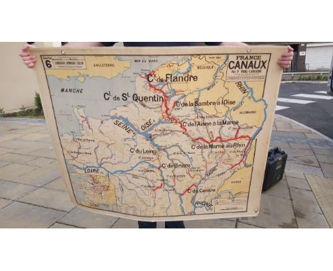
Lot 264
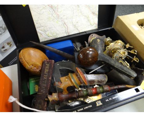
A SILVER MOUNTED OTTER PAD fashioned as a brooch, inscribed "K.D.O.H., June 10, 1929 Underley" (Kendal and District Otter Hounds), a BOOK BY L.C.R. CAMERON titled "Otters and Otter Hunting", Illustrations, Map and Advertisements, publ. L. Upcott Gill , 1908, THREE WHITE METAL MOUNTED CORK BOTTLE STOPPERS, each of slightly different design in the form of a grouse, a stag and a fox, 7.5cm high and "Grenadier, England", A PAIR OF SILVER PLATED TOOTHPICK HOLDERS in the form of hunting boots, 9cm high (7 items)


Lot 2032
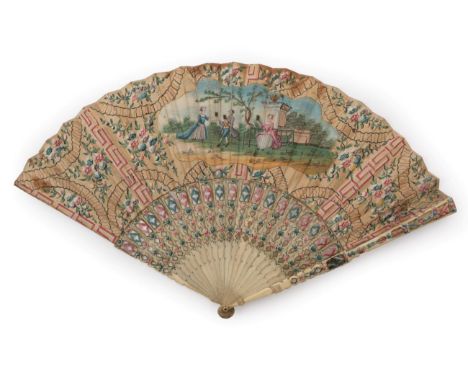
The Claude Glass Fan: An 18th Century Fan, with a double paper leaf, mounted on bone sticks, carved, and painted in pink and blue. The gorge is carved in horizontal bands. I make no apology for letting the words of Judith Elliott herself describe this fan: The central cartouche shows three fashionable young people using Claude Glasses to view the scene behind them (Figs 1 and 2). The obverse is painted with a spray of flowers. Guard length 10.5 inches or 27cm A Claude Glass (or Black Mirror) is a small mirror, slightly convex in shape, with its surface tinted a dark colour. These glasses were used by artists, travellers and connoisseurs of landscape and landscape painting. They had the effect of abstracting the subject reflected in the glass from its surroundings, thus reducing and simplifying the colour and tonal range of scenes and scenery to provide a quality suitable for painting. Therefore, they were used by picturesque artists in England in the late 18th and 19th centuries as a frame for drawing landscapes. The user turned their back on the scene to observe the framed view through the tinted mirror. The glass is named after Claude Lorrain, a 17th century landscape painter, whose name became synonymous with the picturesque aesthetic. William Gilpin, the supposed inventor of the picturesque ideal, advocated the use of a Claude Glass because ''they give the object of nature a soft, mellow tinge like the colouring of that Master''. Claude Glasses were widely used by tourists and amateur artists, who quickly became the targets of satire. These glasses were in use in the English Lake District and are mentioned by Thomas West in his ''A Guide to the Lakes'', published in 1778. He selected four 'stations' around Windermere for excellent views of the largest natural lake in England. These stations were marked on the map of Windermere included in the book on ''A Series of Accurate Maps of the Principal Lakes of Cumberland, Westmorland, & Lancashire'' by Peter Crosthwaite and published in 1809, soon after his death. He was born in the village of Crosthwaite in 1735. Within months of entering service with the East India Company, he commanded the 'Otter', a gunship that protected the trading vessels of the Company from marauding Malay pirates. After ten years, and with failing health, he returned to Cumberland and married a lady from Keswick. In 1780, he opened a museum in Keswick, styling himself: ''Peter Crosthwaite, Admiral of the Keswick Regatta, Keeper of the Museum at Keswick, Guide, Pilot, Geographer and Hydrographer to the Nobility and Gentry''. He showed foresight because the tourist movement had scarcely begun. He surveyed the major lakes and produced accurate maps on which he indicated selected viewing points, thus establishing a fashion for scenic tourism. See the article by Judith Elliott in the FCI Bulletin # 97 Winter 2013 pages 44-45 Purchased at Christie's SK on the 10th December 1996, lot 90, noted as French, circa 1760. The monture is sound and the paint colours remain good. The leaf is a little tired, with some nicks to the upper folds and a few dark marks, not so easy to see as the design is so busy. There is one small hole to the top left of the leaf where a brown stain can be seen. One fold, just in from the upper guard, is partially split as it meets the guard, and at the shoulder of this guard there is a metal plate as a repair. The top leaf layer is lifting in a couple of places but intact behind. The fan is still strong.

![AFTER GUILLAUME SAMSON; 'Iudaea Seu Terra Sancta, In Suas Duodecim Tribus Divisa [...]', a late 18th century copper engraved](https://cdn.globalauctionplatform.com/55b8d229-ab14-4c7a-a166-aa6f009991c3/2a45f46f-4f59-49f7-a0c0-aa7300b55a1b/468x382.jpg)
Lot 849
AFTER GUILLAUME SAMSON; 'Iudaea Seu Terra Sancta, In Suas Duodecim Tribus Divisa [...]', a late 18th century copper engraved hand coloured map of Judea and the Holy Land, cartouche to upper left showing Moses holding the Tablets of Law and cartouche to lower right depicting Adam and Eve in the Garden of Eden, published by Jaillot Paris 1677, 52.5 x 84cm, framed and glazed. Additional InformationCentral vertical fold/crease, foxing and spotting throughout, some fading to colours and staining.

Lot 850
JOSEPH MOXON; an early 18th century map, 'The Travels of St Paul and Other The Apostles, or a Geographical Description of Those Lands and Countries Wherein the Gospel of Christ was First Propagated [...]', hand coloured with eight Biblical illustrations featuring St Paul and dedication to the Lord Bishop of Salisbury lower left, published by Nicolaus Silseder Amsterdam, 31.5 x 46.5cm, framed and glazed.Additional InformationCentral fold, discolouration, spotting and foxing and some fading to colours. Further folds to the left, right and lower sections. Unfortunately we cannot say if it has been stuck down to the mount, some visible waviness to the paper.

Lot 641
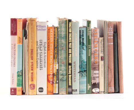
A COLLECTION OF 22 BOOKS including, JUDGES REPORT 1899 by E. Shrapnel Smith, KNOW THE LOCOMOTIVE YOU DRIVE by The English Electric Company, OUTLINE OF G.W. LOCOMOTIVE PRACTICE by H. Holcroft, THE KENNING COLLECTION by A.Vaughan, STEAM TRACTION ENGINES, WAGONS AND ROLLERS IN COLOUR by Brian Johnson, STEAM CARS by Lord Montagu of Beaulieu, MODEL RAILWAY ENGINES by J.E.Minns, STEAM ENGINES AT BRESSINGHAM by Alan Bloom, A CENTURY OF STEAM-ROLLING by R.A.Whitehead, TRACTION ENGINES by Anthony Beaumont, CHRONICLES OF A COUNTRY WORKS by Ronald H. Clark, A GALLERY OF OLD TIMERS by Anthony Beaumont, MODERN MANUAL FOR DRIVERS OF STEAM ROAD VEHICLES by Map, MODERN STEAM ROAD WAGONS 1906 by William Norris, STEAM CARRIAGES AND TRACTION ENGINES by William Fletcher, ENGLISH STEAM WAGON by Ronald H. Clark, RISE AND DECLINE OF THE STEAM-DRIVEN OMNIBUS by Charles E. Lee, THE STEAM LORRY by R.W.Kidner, STEAM UP! by Anthony Beaumont, TRACTION ENGINES PICTURES by Anthony Beaumont, TRACTION ENGINES ON PARADE by Anthony Beaumont, RANSOMES STEAM ENGINES by Anthony Beaumont, TRACTION ENGINES by George Watkins. (38)


Lot 268
Falle, The Rev. Philip - Caesarea: Or an Account of the Island of Jersey, the greatest of the Islands remaining to the Crown of England of the ancient Dutchy of Normandy, printed for T. Wotton, 1734, second edition, contemp. full embossed calf, lacks folding map and Prospect of Elizabeth Castle, 8vo.


Lot 291
MANNEX P. & CO. History & Directory of Furness & West Cumberland. Preston, n.d.; also 5 others Cumbria & Lake District interest. (6).Conditon report:1 - Martineau Harriet; Guide To Windermere, 3rd ed.2 - Walcott, Mackenzie E. C.; A Guide to the Mountains, Lakes and north-West coast of England, London 1860.3 - Middleton, George; Grasmere. The Church, the Churchyard, Rushbearing, Dove Cottage. Ambleside, 1920.4 - W. H. Smith and Son's Reduced Ordnance Map of Lake District & Windermere.5 - Ferguson, Richard S.; Early Cumberland and Westmorland Friends, London 1871.


Lot 169
Snelgrave (William). A New Account of some Parts of Guinea, and the Slave-Trade, 1st edition, printed for James, John, and Paul Knapton, 1734, engraved folding map frontispiece (guard-mounted at an early date, tissue-repair along lower edge), title-page a little spotted and dust-soiled, and with remnants of a heavy pencil inscription, intermittent marginal spotting to text, a few other minor marks, contemporary calf, rebacked, craquelure to sides, restoration to extremities, 8vo (19.6 x 11.5 cm) (Qty: 1)ESTC T136167; Goldsmiths’ 7204; Kress 4197; Sabin 85380. Snelgrave was an active slave trader from 1704 to 1734. His book is 'apologetic of the slave trade and heavy with tales of Africans' sacrificing humans, selling their children into slavery, and engaging in cannibalism. But, more important, it chronicles rebelliousness aboard slave ships and the Dahomean destruction and desolation of Ouidah, an outlet for 20,000 slaves a year' (Parent, Foul Means: The Formation of a Slave Society in Virginia, 1660-1740 , p. 222). It also contains an account of the author's capture by pirates.

Lot 197
Colden (Cadwallader). The History of the Five Indian Nations of Canada, which are dependent on the Province of New-York in America, and the barrier between the English and French in that part of the World ... To which are added, accounts of the several other Nations of Indians in North-America, their numbers, strength, etc., and the treatises which have been lately made with them, 1st UK edition, for T. Osborne, 1747, folding engraved map (repaired verso), a few minor spots, ownership inscription (James Gordon) at head of title, contemporary calf, a couple of small stains, 8vo (Qty: 1)ESTC T36482; Howes C-560; Sabin 14273. First UK edition, greatly expanded, of 'the first history of the Iroquois Confederation' (Howes), first published in New York in 1727.
![[Mitchell, John]. The Contest in America between Great Britain and France, with its Consequences and Importance; giving an ac](https://cdn.globalauctionplatform.com/743f0bc2-9e54-4e80-b1cf-aa5d00bda42e/4ed42730-1315-4c71-82eb-aa5d00e4685f/468x382.jpg)
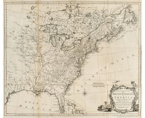
Lot 219
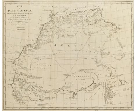
[Mitchell, John]. The Contest in America between Great Britain and France, with its Consequences and Importance; giving an account of the views and designs of the French, with the interests of Great Britain, and the situation of the British and French colonies, in all parts of America: in which a proper barrier between the two nations in North America is pointed out, with a method to prosecute the war, so as to obtain that necessary security for our colonies, 1st edition, for A. Millar 1757, small manuscript correction to contents leaf, light marginal toning front and rear, contemporary previous owner inscription, bookplate of Hugh Rose Younger of Kilraick [Kilravock], contemporary sprinkled calf gilt, spine with red label, 8vo (Qty: 1)ESTC T34013 (citing four copies in UK libraries); Howes M677; Sabin 49693. Mitchell (1711-1768) is best remembered today for his comprehensive map of North America, which was first published by Millar in 1755 and was later used at the Treaty of Paris to establish the boundaries of the newly formed United States. In 1757 Millar published a second edition of the map and the first edition of Mitchell's book, which 'shows an unusual knowledge and familiarity with the internal geography of America and the affairs of the French on the lakes, the Ohio, and in Western Virginia' (Sabin); the map is a wall-size item and should not be considered as part of the collation of the octavo volume, contrary to ESTC.

Lot 235
Charlevoix (Pierre Francois Xavier de). Journal of a Voyage to North-America. Undertaken by Order of the French King. Containing the Geographical Description and Natural History of that Country, particularly Canada, 2 volumes, 1st edition in English, for R. and J. Dodsley, 1761, half-titles, folding engraved map, a little minor spotting, bookplates of Hugh Rose younger of Kilraick [Kilravock], contemporary sprinkled calf gilt, 8vo (Qty: 2)ESTC T73046; Howes C-308; Sabin 12139.
Lot 253
Knox (John). An Historical Journal of the Campaigns in North-America for the Years 1757, 1758, 1759, and 1760: Containing the most Remarkable Occurrences of that Period; particularly the two Sieges of Quebec, the Orders of the Admirals and General Officers; Descriptions of the Countries where the Author has served, with their Forts and Garrisons; their Climates, Soil, Produce, 2 volumes, 1st edition, for the author, 1769, engraved portrait frontispieces of generals Amherst and Woolfe, folding engraved map of British Dominions in America by Thomas Kitchin, errata leaves to rear, occasional light soiling, bookplates and ownership inscriptions of George Gun and John Long, contemporary sprinkled calf, rebacked with original spines relaid, a little rubbed, 4to (Qty: 1)ESTC T92897; Howes K-220; Sabin 38163.
Lot 263
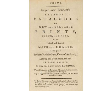
Bookseller's catalogue. For 1775. Sayer and Bennett's Enlarged Catalogue of New and Valuable Prints, in Sets, or Single; also Useful and Correct Maps and Charts; likewise Books of Architecture, Views of Antiquity, Drawing and Copy Books, &c. &c. in Great Variety, At No. 53, in Fleet-Street, London; Where Gentlemen for Furniture, Merchants for Exportation, and Shopkeepers to sell again, May be supplied with the greatest Assortment, on the most reasonable Terms..., [London], 1775, Appendix at rear with separate pagination and collation, lightly toned throughout, verso of front free endpaper with contemporary ownership signature of Philip Griffin, Warnford, Hants, front pastedown with armorial bookplate of Henry St. Andrew St. John, front free endpaper with bookplate of Martin and Josephine Orskey, and with ink inscription 'M. Orskey 1964', modern calf-backed contemporary marbled boards (rubbed), 8vo in 4s (Qty: 1)Provenance: Philip Griffin was rector of the village of Warnford in Hampshire. Henry St. Andrew St. John (1796-1874) was also a clergyman, whose ancestors hailed from Bletsoe in Bedfordhire, and his portrait hangs in Lydiard House, Swindon, Wiltshire. ESTC T152186 (listing just two locations, British Library and Göttingen University, Germany). ESTC lists three other similar catalogues put out by Sayer in the years 1766, 1774 and 1786. All are scarce. Robert Sayer (1725-1794) was a major British publisher and printseller. In 1745 he purchased the business of map and globemaker John Senex and went into partnership with Philip Overton, in 1748 marrying Overton's widow Mary. In 1774 Sayer entered partnership with his journeyman John Bennett and traded as Sayer & Bennett but Bennett apparently went mad in 1783. On Sayer's death, the business was taken over by his assistants Robert Laurie and James Whittle.
![Grose (Francis). The Antiquities of England and Wales, 8 volumes, 'new edition', Hooper & Wigstead, [1784-7], engraved fr](https://cdn.globalauctionplatform.com/743f0bc2-9e54-4e80-b1cf-aa5d00bda42e/5ec4c052-2c0c-4d3c-bc1e-aa5d00e4913f/468x382.jpg)
Lot 281
Grose (Francis). The Antiquities of England and Wales, 8 volumes, 'new edition', Hooper & Wigstead, [1784-7], engraved frontispiece and vignette title-page to each volume, folding map to volume 7, portrait by Bartolozzi to volume 8, 655 engraved plates including views, antiquities and plans, a few folding, engraved vignette county maps, tissue-guards, offsetting, occasional spotting to leaves adjacent to plates and to a few plate margins, vignette map of Gloucestershire imperfectly printed to partial loss of cartouche, marbled edges and endpapers, bound green silk page-markers, early-19th-century russia elaborately gilt, octofoil devices on semé dot ground to spine compartments, covers with concentric decorative frames incorporating an oblique curlicued palmette roll, elaborate cornerpieces built up from various floral and leaf-form tools on semé dot ground, joints slightly rubbed in places, 4to (27.5 x 20.8 cm) (Qty: 8)The binding is similar to known examples by Regency binder Bartholomew Frye, an immigrant of German origin who by 1816 had established his own workshop in Halifax, possibly after an apprenticeship with Edwards, and later worked in Manchester and Liverpool. See Ramsden, Outside London , p. 76.
Lot 301
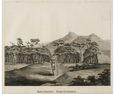
Paterson (William). A Narrative of Four Journeys into the Country of the Hottentots, and Caffraria, in the Years 1777, 1778, 1779, 2nd edition ('corrected'), printed for J. Johnson, 1790, 19 copper-engraved plates (Bushmen's Habitations, Hottentots, Horned Snake, Camelopardalis, and 15 botanical subjects), folding engraved map at rear with some light spotting and minor waterstain to lower right edge, early ink ownership signature to title of Marcus Gage, contemporary half calf gilt in very good condition, 4to (Qty: 1)Cox I p. 390; ESTC T89158; Mendelssohn II p. 143. An account of four expeditions into the Hottentot Country and Caffraria, containing descriptions of the geography, botany and zoology of the region, as well as the dress and conduct of the natives, in particular the author's encounter with the Caffres and their chief, Khouta, in a region east of the Great Fish River which the explorer Sparrman did not reach (Paterson's and Sparrman's routes are marked on the folding map contained in this work). 'Although the principal feature of the work is a description of the botanical specimens ... there are many interesting notes respecting the natives, with a few remarks on the Dutch colonists' (Mendelssohn). Paterson was later appointed governor of New South Wales but 'historians have rightly judged him more important as a natural scientist than as an administrator' (ODNB).
Lot 305
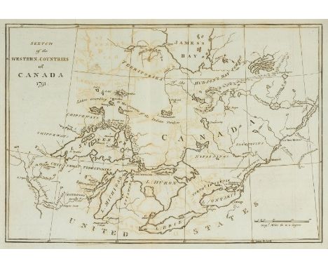
Long (John). Voyages and Travels of an Indian Interpretor and Trader, describing the Manners and Customs of the North American Indians; with an account of the posts situated on the River Saint Laurence, Lake Ontario, etc. to which is added, A Vocabulary of The Chippeway Language. Names of Furs and Skins, in English and French. A list of words in the Iroquois, Mohegan, Shawanee, and Esquimeaux Tongues, and a table, shewing the Analogy between the Algonkin and Chippeway Languages, 1st edition, printed for the author, 1791, title, dedication, list of subscribers and preface (i-x), errata leaf, folding engraved map of Canada, titled Sketch of the Western Countries of Canada 1791, 295 pages, light offsetting from the engraved map to facing text leaf, title lightly toned, generally a very good copy, modern antique-style half calf gilt, 4to (Qty: 1)Sabin 41878; Howes L443; Vail 878; Staton & Tremaine 597. Large-paper copy. '[Long] lived for a time on the Caughnawaga mission, and fought among the pro-British Indians in the American revolutionary war. He travelled and traded throughout the Upper Country, about Hudson Bay, and returned penniless to England in 1788. His is a graphic record of Indian life and customs and of conditions in the fur trade during the furious competition of the Montreal traders among themselves and with the Hudson's Bay Co.' (Staton & Tremaine). 'Of considerable importance also are his lengthy vocabularies of Inuit, Mohawk, Algonkin, Mohegan, Shawnee, and Ojibwa terms.' Charles A. Bishop, (Dictionary of Canadian Biography)
Lot 306
Saugnier (F. & P.R. de Brisson). Voyages to the Coast of Africa, by mess. Saugnier and Brisson: Containing an account of their shipwreck on board different vessels, and subsequent slavery, and interesting details of the manners of the Arabs of the desert, and of the slave trade as carried on at Senegal and Galam, translated from the French, 1st edition in English, for G. G. J. and J. Robinson, 1792, half-title, folding engraved map, a little light spotting, contemporary ownership inscription of Marcus Gage at head of title, contemporary polished calf gilt, red label to spine, 8vo (Qty: 1)Cox I p. 391; ESTC T147513.
Lot 312
Bartram (William). Travels through North and South Carolina, Georgia, East and West Florida, the Cherokee Country, the Extensive Territories of the Muscoculges or Creek Confederacy, and the Country of the Chactaws. Containing an account of the soil and natural productions of those regions, 1st Dublin edition, for J. Moore [and others], 1793, engraved portrait frontispiece, folding engraved map of East Florida, 7 engraved plates (one folding), occasional minor offsetting and spotting, contemporary previous owner signature of Marcus Gage to title, contemporary tree calf gilt, spine a little rubbed, 8vo (Qty: 1)ESTC T121441; Howes B223; Sabin 3870. First published in Philadelphia in 1791 and London in 1792, the work records the author's extensive travels in the territories of the Creek, Cherokee and Choctaw Indians, as far west as the Mississippi River. The author had great interest in the customs and manners of the Indian tribes, fur traders and forest life. 'A work of high character well meriting its wide esteem' (Howes).
Lot 320
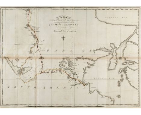
Hearne (Samuel). A Journey from Prince of Wales's Fort in Hudson's Bay, to the Northern Ocean. Undertaken by Order of the Hudson's Bay Company, for the Discovery of Copper Mines, a North West Passage, &c. In the Years 1769, 1770, 1771, & 1772, 1st edition, A. Strahan and T. Cadell, 1795, large folding engraved map with routes coloured in outline, 4 folding enraved plans, 4 folding engraved plates, publisher's advertisement leaf with Directions to Binder to verso at end, small marginal repair to one plan, contents leaf and at gutter of page 241, occasional light spotting, top edge gilt, later maroon half morocco gilt, joints and edges a little rubbed, 4to (Qty: 1)ESTC T146967; Hill I p.141; Sabin 31181 (with incorrect plate count). Large-paper copy. 'It was the first of a long series of Arctic voyages and travels which reflect so much honor on the British Press. Its publication is due to the celebrated explorer La Perouse who captured Fort Albany, Hudson's Bay and found the MS. of Hearne. The fort was afterwards surrendered to the British, but La Perouse stipulated for the publication of this work by the Hudson's Bay Company, which stipulation was honorably fulfilled in this beautiful volume ... The author will always be remembered as the first white man that ever gazed on the dreary expanse of the Arctic or Frozen Ocean from the northern shores of the Continent of America' (Sabin).
Lot 323
Le Vaillant (François). New Travels into the Interior Parts of Africa, by the way of the Cape of Good Hope, in the years 1783, 84 and 85, 3 volumes, 1st edition in English, 1796, half-titles (one repaired), folding engraved map with routes in outline colour, 22 engraved plates, including 6 folding, occasional light offsetting and spotting, contemporary ownership inscriptions of Marcus Gage at head of titles, later cat's-paw calf by Mackenzie, Dublin (pencil note at front of volume 1), spines slightly faded, red and green labels, 8vo (Qty: 3)ESTC 87469; Mendelssohn I pp. 890-92. During his second expedition to southern Africa, undertaken on behalf of the Dutch East India Company, Le Vaillant (1753-1824) travelled through Namaqualand, Damaraland, Bechcuanaland and the Kalahari Desert.
Lot 336
Phillips (Richard, publisher). Modern London; being the History and Present State of the British Metropolis, printed for Richard Phillips, 1805, engraved folding panorama as frontispiece, folding map, 21 engraved plates, section-title 'Description of the Plates, representing the Itinerant Trades of London in their Ordinary Costume; with Notices of the Remarkable Places Given in the Background', followed by 31 hand-coloured etched plates each with accompanying description leaf (these plates with Ivy Mill watermarks 1807, the description leaves watermarked 1803), all other text-leaves present as called for including final advertisement leaf, text (aside from description leaves) slightly browned and with occasional marginal spotting, coloured plates s lightly offset, one (Mackerel') spotted, all other text-leaves present as called for small marginal worm-track to last few leaves, attempted repair to final advertisement leaf, contemporary tan calf gilt by J. Forsyth of Elgin (oval ticket to front pastedown), 4to (26.2 x 19.5 cm) (Qty: 1)Abbey 271 (for the colour plates only); Tooley 370; binder not in Ramsden, Outside London . Tooley identifies six issues of the colour plates, which are by William Marshall Craig, and describes three of them as having been issued separately from Modern London , but none of them conforms exactly to the plates in this copy. Abbey describes the colour plates as a 'supplement' to Phillip's work, which was first published in 1804.
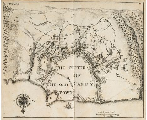
Lot 34
Palmer (Roger, Earl of Castlemaine). An Account of the Present War between the Venetians and Turk; with the State of Candie: (In a Letter to the King, from Venice.), 1st edition, printed by J. M. for H. Herringman, 1666, engraved portrait frontispiece of the Earl of Castlemaine by Faithorne, double-page engraved plan of Old Candy Town (present-day Heraklion) by Wenceslaus Hollar, double-page engraved map of the Eastern Mediterranean, contemporary sheep, old reback, 8vo (Qty: 1)Blackmer 1239; ESTC R7289; Wing C1238. 'Charles II had asked the Earl of Castlemaine to keep him informed of events while he toured Europe, and on Castlemaine's arrival in Venice he sent the King a long letter of information on the war in Crete between the Venetians and the Turks, which was then entering its final phase. When Castlemaine returned to England he received permission to print the letter, which is a basic source of information on the 20-year battle in Crete' (Blackmer).
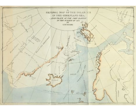
Lot 363
Manby (George William). Journal of a Voyage to Greenland, in the Year 1821, 1st edition, G. and W. B Whittaker, 1822, folding hand-coloured map (slight partial toning to flap), 20 lithographic plates after J. D. Harding, illustrations, a little light offsetting and spotting, bookplate of James Donald and Lilford Library label to front pastedown, original boards, spine label chipped, some edge wear, 4to (Qty: 1)Sabin 44195; not in Abbey. A scarce whaling and Arctic item, and a strikingly illustrated account of Captain Scoresby's voyage on the Baffin, undertaken to test his new harpoon design.

Lot 367
Moorsom (William Scarth) Letters from Nova Scotia; Comprising Sketches of a Young Country, 1st edition, H. Colburn and R. Bentley, 1830, folding engraved map, 3 engraved plates, bound without advertisements to rear, one or two light spots, bookplate and shelfmark label, contemporary calf gilt, head of spine repaired, 8vo (Qty: 1)Sabin 50472.

Lot 400
Nicholls (Sutton, 1668-1729). The Compleat Auctioneer, circa 1700, uncoloured engraving of a book auctioneer standing behind a stall of books, with two ladies and two gentlemen beside him, and a tree behind, the tree bearing a printed notice 'A Choice Collection of Books being the Library of the late famous Unborn Doctor, are to be put to Sale this Day and to continue untill all be Sold, at Mr L-GS Auction in the North West Corner of Middle Moorfields. Cattalogues may be had at most of the eminent Booksellers in the four Quarters of Moorfeilds Gratis, the Books may be Seen before or at the time of Sale', two short closed-tears to margins (repaired), plate size 27.5 x 18.5 cm (10.75 x 7.25 ins), with margins, sheet size 28.5 x 20 cm (11.25 x 7.75 ins), 19th century black and gilt moulded frame, glazed (Qty: 1)British Museum, Personal and Political Satires 1415. Rare. The earliest known representation of a book auction. The table of books on display include many bawdy titles of the restoration era, such as 'Sch: of Venus', 'Aratines Post.', 'Play of Sodom', 'Poems by the R H the E[arl] of R[ochester], alongside standard medical works of the period, 'Culp Midw', 'Artist[otles] Mast[erpiece]', and other various titles including 'Don Quixot', 'Og[ilby] America' (also his Roads Africa and Asia), 'Heylins Cos[mography]'. Below the image is printed 8 lines of verse: 'Come Sirs, and view this famous Library, 'Tis pity Learning shou'd discourag'd be: Here's bookes (that is, if they were but well Sold) I will maintain't are worth their weight in Gold Then bid apace and break me out of hand: Ne'er cry you don't the Subject understand: For this I'll say - howe'er the Case may hit, Whoever buys of me, - I teach 'em Wit.' Book auctions first became popular in the Low Countries, where Lodewijk Elzevier was granted permission to hold them in The Hague in 1596. The first recorded book auction in England was held in London in 1676, when the library of the clergyman Lazarus Seaman was put up for sale at his own house. Sutton Nicholls, engraver, printseller, draughtsman and globemaker, worked for the map publishers Philip Lea, Robert Morden, Edward Wells, Henry Overton, Thomas and John Bowles and others.


Lot 71
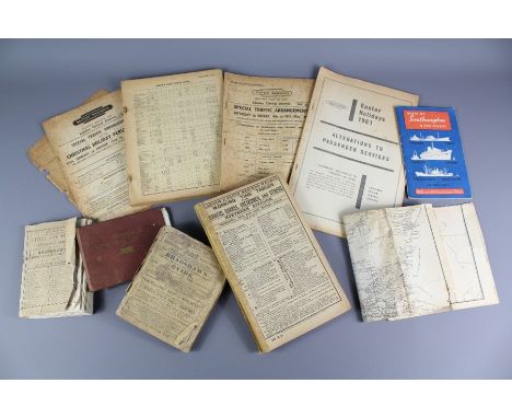
A Private Collection of Railwayana Books. This lot includes a copy of Osborne's Timetable July 1840, Bradshaw's Railway and Steam Navigation Guide 1844 and 1859, Great Western Railway Time Table 1841, 1st Ever Bradshaw's International Air Guide 1934, Bradshaw's Plans of the most important Cities and Towns Continental Europe (complete), a reprint of the Midland Railway Rules and Regulations Guidance for Officers and Men June 1871, Nicholson & Co's Railway Guide for May 1866, The South Downs Railway Guide by The Tramp circa 1910, Knights Railway Time Tables 1949, Midland Railway Times Tables 1857, Charles Goodall's Railway Time Table 1877, London Midland and Scottish Railway Map of Scotland, Wilson's Railway Law, Isle of Wight Central Railway Working Time Table 1909, London and South Western Railway Time Tables 1922, International Railway Steam Navigation Guide C.R Chisholm & Co March 1870, GWR Popular Day Trips 1885, Sligo, Leitrim & Northern Counties Railway Time Table Poster 1957, London & North Western Railway Working Time Tables Drivers, Guards and Breakmen Northern Division Feb 1913 together with a 1ed Thomas The Tank Engine by The Rev. W. Awdry publ. by Edmund Ward and a quantity of Continental early 20th Century Train Time Tables and regional tourist guides in France including a 1907 edition of Island of Corsica and some early 20th century train menu's.


Lot 55
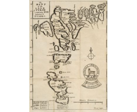
Debes (Lucas Jacobsen). Faeroae, & Foeroareserata: that is A Description of the Islands & Inhabitants of Foeroe: being seventeen islands, subject to the King of Denmark lying under 62 deg. 10 min. of North Latitude, Wherein several secrets of Nature are brought to Light, and some Antiquities hithero kept in darkness are discovered, Written in Danish by Lucas Jacobson Debes, M.A. and Provost of the Churches there. English'd by J.S. Doctor of Physick, printed by F.L. for William Iles, at the Flower-de-Luce in Little-Brittain, over against St. Bartholomews Gate, 1676, [24] + 408 pages, folding engraved map facing title (bound upside-down), and folding engraving of the whirlpool of Sumsoe, contemporary blind-ruled sprinkled full calf, a little rubbed and slight wear to joints, 12mo (Qty: 1)Wing D511. First English translation by John Sterpin of a work first published in Danish in 1673, containing the first detailed map of the Faroe Islands. Lucas Jacobson Debes (1623-1675) was a Danish priest who came to the Faroes in 1652, and became head of the grammar school there.

Lot 96
Mather (William). The Young Man's Companion: Or, Arithmetick made Easie. With plain directions for a young man, to attain to read and write true English, and short-hand or characters. And also very easie rules for measuring land... The use of Gunter's Quadrant... Choice experiments in physick and chyrurgery... With choice presidents in the law, 4th edition ('with very large additions'), 1695, folding engraved map, 2 engraved plates (one folding), diagrams and illustrations, folding table, advertisement leaves at end, occasional light spotting, contemporary mottled calf, small splits to joints, light edge wear, 12mo, contained in modern cloth clamshell box (slightly rubbed) (Qty: 1)Wing M1287B

-
109182 item(s)/page