We found 109182 price guide item(s) matching your search
There are 109182 lots that match your search criteria. Subscribe now to get instant access to the full price guide service.
Click here to subscribe- List
- Grid
-
109182 item(s)/page


Lot 4
(SUTCLIFFE THOMAS). Crusoniana or Truth Versus Fiction Elucidated in A History of the Islands of Juan Fernandez by The Retired Governor of that Colony. 2 eng. "frontis." (bound at p.30 & p.175) & title vignette, litho map & 7 plates (all as called for). Manchester, Published by the Author, 1843; bound in dark half calf with "Circular" followed by The Earthquake of Juan Fernandez as it Occurred in the Year 1835, Manchester 1839; "A Statement of Facts"; An Exposition of Facts relating to the Rise and Progress of the Woollen, Linen and Cotton Manufactures of Great Britain (with fldg. pedigree), Manchester, 1843; "Opinions of the Press" & list of Patrons & Subscribers.

Lot 239
GREEN WILLIAM, of Ambleside. The Tourist's New Guide Containing a Description of the Lakes, Mountains & Scenery in Cumberland, Westmorland & Lancashire With Some Account of Their Bordering Towns & Villages. 2 vols. Fldg. eng. map & 12 etched plates. Orig. prntd. brds. bearing adverts, neatly rebacked. Kendal, 1819.

Lot 263
(WASHBOURN JOHN). Bibliotheca Gloucestrensis, A Collection of Scarce & Curious Tracts Relating to the County & City of Gloucester Illustrative of, & Published during, the Civil War. Eng. port. frontis, eng. map & one eng. plate (only?). Subscriber's list. Quarto. Neatly rebound cloth backed brds. Gloucester, 1825.

Lot 219
KIRSOPP JOHN. Supplement to Plotted Vertical Sections of the Northumberland & Durham Coalfield. Large fldg. col. map. Details of colliery owners & pits, analysis of coals sold, etc. Folio. Half dark morocco, apparently pres. copy from the author to John Gerrard. Published by the Author, 1908.


Lot 209
NATIONAL COAL BOARD, DURHAM DIVISION. Proposed Reconstruction of Wardley/Usworth Collieries, Stage II Submission & Part Stage III. Thick quarto portfolio in dark leather with much typescript information incl. fldg. tables followed by many slipped in fldg. maps & plans. September 1950. All typeset illustrations and maps. Map features are hand-coloured.


Lot 53
THOMAS BERTRAM. Arabia Felix ... With a Foreword by T. E. Lawrence. Illus. & fldg. map. Orig. cloth, some fading & wear. 1936; also A. F. R. Wollaston, From Ruwenzori to the Congo, illus., orig. cloth, 1908 & Albert B. Lloyd, In Dwarf Land & Cannibal Country, illus., orig. cloth, much foxing, 1907. (3).

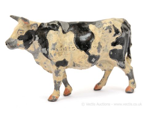
Lot 7409
Britains - Map of the World Cow, Second Version, comprising: Friesian Cow with Black Markings forming a World Map along its Flanks, made as a Nestle` s Milk promotional item in 1924 for the British Empire Exhibition. This second version example has the wording "Nestles Milk" & "The World Cow" cast onto its Flanks. Some paint chipping otherwise generally Fair to Good overall.
Lot 183
Powell-Cotton, Percy Horace Gordon In Unknown Africa a Narrative of Twenty Months' Travel and Sport in Unknown Lands and among New Tribes. London: Hurst and Blackett, Limited, 1904. First edition, 8vo, original pictorial cloth gilt, 2 colour plates, 2 folding maps, halftone photographic plates throughout, maps spotted, ownership inscription to title-page;Idem. A Sporting Trip through Abyssinia. London: Rowland Ward, Limited, 1902. First edition, 8vo, original red cloth, zebra-pattern endpapers, photogravure frontispiece, folding map in end-pocket, spine faded, pale mottling to covers, wear to bottom edges of boards, spotting to edges of text-block;Crum, Frederick Maurice. With the Mounted Infantry in South Africa. Being Side-Lights on the Boer Campaign 1899-1902. Printed for Private Circulation. Cambridge: Macmillan and Bowes, 1903. First edition, 8vo, original cloth, inscribed by the author on the front free endpaper;Idem. With Riflemen, Scouts, and Snipers, from 1914 to 1919. Oxford: for private circulation, 1921. First edition, 8vo, original green wrappers, 7 halftone photographic plates, separation along joints, evidence of old adhesive-repair;Idem. Memoirs of a Rifleman Scout. Stirling: A. Learmonth & Son, c.1951. First edition, 8vo, original cloth-backed boards, photographic illustrations throughout;Hesketh-Prichard, H. Sniping in France. With Notes on the Scientific Training of Scouts, Observers, and Snipers. London: Hutchinson & Co., c.1920. First edition, 8vo, original cloth, 28 plates;Greener, W. W. Sharpshooting for Sport and War. London: R. W. Everett & Co., 1900. First edition, 8vo, original wrappers, illustrations in text;and 7 others
Lot 58
Travel and social anthropology 9 works Malinowski, Bronislaw. The Sexual Life of Savages in North-Western Melanesia. London, 1929. First edition, 8vo, 96 plates, original white linen-backed blue cloth, lettered in gilt;Knox, Robert. An Historical Relation of Ceylon. Glasgow: J. Maclehose, 1911. 8vo, one of 100 copies printed on hand-made paper, plates, folding map, original vellum-backed red cloth gilt, spine gilt, t.e.g., others uncut;Ashley-Montagu, M.F. Coming into Being among the Australian Aborigines. London: G. Routledge, 1937, First edition, 8vo, original blue cloth;Elwin, Verrier. The Muria and their Ghotul. Bombay, Geoffrey Cumberlege, O.U.P. [Indian Branch], 1947, 8vo, plates, maps, original red cloth uncut;Elwin, Verrier. The Baiga. London: J. Murray, 1939. First edition, 8vo, plates, original maroon cloth, dustwrapper repaired;Elgood, Cyril. A Medical History of Persia and the Eastern Caliphate. Cambridge: University Press, 1951, 8vo, plates, original green cloth;Madariaga, Salvador de. Christopher Columbus. London, 1939. 8vo, plates, maps, original green pictorial cloth gilt;Sarmiento de Gamboa, Pedro. History of the Incas... and the Execution of the Inca Tupac Amaru. Cambridge: Hakluyt Society, 1907-08. 2 parts: 1 volume in original cloth, and Supplement in original blue wrappers (in original envelope, repaired);Hunter, John D. Memoirs of a Captivity among the Indians of North America from Childhood to the Age of Nineteen. With anecdotes descriptive of their manners and customs. To which is added, some account of the soil, climate and vegetable productions of the territory Westward of the Mississippi. A New edition, with portrait. London: Longman, Hurst, Rees [&c.], 1823. 8vo, lithographed portrait frontispiece, 4pp. advertisements at beginning, engraved bookplate of Sir William Middleton Bart., of Shrubland Park, original boards, uncut, paper label to spineNote: Note: The third edition of John D. Hunter's Memoirs of a Captivity was published in 1824, so this 'new edition' would appear to be the second edition. This copy contains the rare lithographed frontispiece by C.R. Leslie printed by Hullmandel, which was not present in the copy examined for the Wagner-Camp entry, or in the Library of Congress copy. Wagner-Camp notes that "Hunter's autobiography includes his story of a journey across the mountains to the Pacific Ocean, `on the south side of the Chok-a-li-lum (Columbia River)'." Wagner doubted the veracity of this account, although he accepted Hunter's description of life among the Kansas and Osage Indians as authentic. He claimed to have been abducted at an early age by Kickapoo Indians, but escaped to white settlements to get an education. He visited London where he was lionised in 1823-34 and then returned to America where he was murdered by Cherokees.
Lot 45
Netherlands; Germany; Rhineland Admirandorum quadruplex spectaculum delectum, pictum, et aeri in cisum, per Johannem van Call. Amsterdam: Pieter Schenk, c.1700. Oblong 4to, 19th-century half calf, engraved throughout, with allegorical title-page, 64 plates (views of Amsterdam, The Hague, Het Loo palace, and the Rhineland), 4 calligraphic part-titles, dedication leaf, and mezzotint portrait of Frederick Duke of Saxony, lacking 7 plates (71 called for) and register leaf, part-titles, dedication leaf and portrait all bound out of order, title-page repaired verso, light foxing and a few other marks to margins, binding rubbed. Together with:[Denmark] [Album of maps and views of Denmark mainly by Jonas Haas] 1760s. 4to (19 x 19cm), contemporary Dutch floral boards, contents comprise: 1) Generalem et prorius novam Siaelandiae tabulam geographicam, folding map of Zaeland, opening to 55 x 45cm; 2) Den Kongel. Residentz Stad Kiobenhafn ... 1764, folding plan of Copenhagen, approx. 55 x 40cm, a few small holes at folds; 3) Folding panorama of Copenhagen, 1764; 4) Folding plan of Frederiksberg; 5) Folding view of Frederiksberg slotsgaard; 6) Costume plate; 7-13) Further views of buildings and cities including Sophienberg palace, Fredensborg, etc.
Lot 61
Sporting books 12 works Sinigaglia, Leone. Climbing Reminiscences of the Dolomites. London: T. Fisher Unwin, 1896. 8vo, frontispiece, folding map, 38 plates, contemporary green morocco gilt, gilt doublures over red printed silk endpapers, a little rubbing;Whymper, Edward. Travels Amongst the Great Andes of the Equator. London: John Murray, 1892. 2 volumes (including Supplementary Appendix), 8vo, frontispiece, single-page map, 2 folding maps including one in rear pocket, 19 plates, folding plan of Quito, with 14 additional plates in the Supplementary volume, original green cloth gilt, bookplates, some dampstaining to supplementary volume;Ball John. Peaks, Passes, and Glaciers. London: Longman, Green, Longman, and Roberts, 1859-1852. Third edition of volume 1, 2 volumes, 8vo, contemporary red half morocco gilt, upper cover of volume 1 detached, bookplates of Archibald Rogers;James, David. That Frozen Land. London: The Falcon Press, 1949. 8vo, original red cloth gilt;Whymper, Edward. Chamonix, and the Range of Mont Blanc. London: John Murray, 1896. 8vo, original red cloth gilt;Haskett Smith, W.P. Climbing in the British Isles. London: Longmans, Green, and Co., 1894. 12mo, original red cloth gilt;Wilson, Claude. Mountaineering. London: George Bell & Sons, 1893. 12mo, original green cloth;Barrow, John. An Account of Travels into the Interior of Southern Africa... London: T. Cadell Jun. and W. Davies, 1801. Volume 1 only, contemporary diced calf, rebacked retaining portions of original spine, repairs to hinges, repair to title-page, bookplates, lacking maps;Scrope, William. Days and Nights of Salmon Fishing in the Tweed. London: John Murray, 1843. First edition, 8vo, frontispiece, additional title-page and 10 (of 11) coloured lithographs only, contemporary red half morocco gilt, upper cover detached;Millais, J.G. Game Birds and Shooting-Sketches. London: Henry Sotheran & Co., 1894. Second edition, 8vo, frontispiece, plates and illustrations in text, original pictorial cloth;St. John, Charles. Natural History & Sport in Moray. Edinburgh: David Douglas, 1882. 8vo, engraved plates, contemporary half calf, some offsetting from tissue guards;Rollo, W. Keith. The Art of Fly Fishing. London: H. F. & G. Witherby, [1931]. Second edition, 8vo, original cloth, ownership signatures and blindstamp to endpapers
Lot 254
Tolkien, J. R. R. The Lord of the Rings London: George Allen and Unwin Ltd, 1969. First india-paper edition, 8vo, original black cloth decorated in silver and gilt, 2 folding maps, full-page map in text, spine very slightly sunned, slipcase rubbed [Hammond A5h];Stevenson, Robert Louis. Island Nights' Entertainments. Consisting of the Beach of Falesa. The Bottle Imp. The Isle of Voices. London: Cassell & Company Limited, 1893. First edition, 8vo, original blue pictorial cloth gilt, frontispiece, colour map, 26 plates (counted in pagination), price on list of publications facing half-title amended in manuscript;Keats, John. Endymion: A Poetic Romance. London: Taylor and Hessey, 1818 [c.1900]. Facsimile edition, 8vo, original cloth, paper spine-label, largely unopened;Henley, W. E. (editor). Certain Tragical Discourses of Bandello. Translated into English by Geffraie Fenton anno 1567. With an Introduction by Robert Langton Douglas. London: David Nutt, 1898. One of 18 copies on Japanese paper, this copy 'marked 'File copy' on limitation page, 2 volumes, 4to, original white glazed paper boards, unopened, wear to spine-ends and joints, covers slightly soiled;Burton, Richard F (translator). The Carmina of Caius Valerius Catullus. Now first completely Englished into Verse and Prose. London: printed for the translators ... for private subscribers only, 1894. One of 1,000 copies on hand-made paper, 8vo, original quarter japon, spine discoloured, wear to tips;Baillie-Grohman, William A. & F (editors). The Master of Game by Edward, Second Duke of York. London: Chatto & Windus, 1909. 8vo, original vellum gilt, 24 plates, occasional spotting to text;and 4 others including D. H. Lawrence, Lady Chatterley's Lover, [Paris]: privately printed, 1929, author's unabridged popular edition, contemporary cloth, retaining original wrappers
Lot 14
Scotland Collection of maps, 18th and 19th century Mackenzie, Murdoch. Four large coastal charts, 1775, engraved, all folding and on multiple sheets, comprising: The Mouth of Solway Firth, London (74 x 135cm, slightly soiled, reinforcements verso); Solway Firth (103 x 107cm, on multiple sheets, folding, reinforcements verso, small hole at one intersection of folds); The West Side of the Island Mull, with the Islands Tiri and Coll (78 x 110cm, toning, fraying along edges); The South Part of Argyle Shire, from the Mule of Cantire to Jura and Ila (115 x 115cm, browning, reinforcement along right-hand edge);Thomson, James. [Collection of maps from The Atlas of Scotland, 1832]. Engraved, hand-coloured in outline, all folding, most approx. 54 x 70cm (a few on multiple sheets and consequently larger), with inset views, and comprising: Northern Part of Ayrshire (70 x 100cm, repairs verso); Southern Part of Ayrshire (small repair verso); Shetland Islands (2 copies, both with offsetting); Orkney Islands (spotting); Skye Island; Western Isles; Middle Part of the Western Isles; Kincardine Shire; Northern Part of Angusshire; Dumbartonshire; Renfrew-Shire; County of Wigton or Shire of Galloway; Kirkcudbright-Shire (on two conjoined sheets: southern and northern parts, total dimensions approx. 54 x 140cm); Selkirk Shire; Southern Part of Roxburgh Shire (loss to right-hand margin); Northern Part of Roxburgh Shire (loss to left-hand margin evidently where previously attached to preceding map);[Palairet, Jean]. 1e Carte d'Ecosse, 1754. Engraved, hand-coloured, folding, 54 x 80cm, decorative title cartouche, inset map of Shetland;Tirion, Isaak. Nieuwe Kaart van 'tnoorder gedeelte van Grootbritannie behelzende het Koningryk Schotland, c.1750. Engraved, hand-coloured in outline, inset map of Shetland, 40 x 40cm, small stain to lower left corner;and some 8 other Scottish maps including A. K. Johnston, Plan of the Lands of Invereolan, Inverharnan, and Drimchouhes, Glen Etive, 1832 (laid down), J. Cary, A New and Correct Map of the South Part of Scotland, c.1780; and similar
![Bible; English; Authorised Version [The Holy Bible, conteyning the Old Testament, and the New] [London: Robert Barker, probab](https://cdn.globalauctionplatform.com/bc80e8b7-d26a-42a0-aa0c-b06900ce413d/0103dcf2-d716-43da-95c5-b07400c807b1/468x382.jpg)
Lot 226
Bible; English; Authorised Version [The Holy Bible, conteyning the Old Testament, and the New] [London: Robert Barker, probably 1617].Folio (39.9 x 25cm), modern calf, dated 1611 on spine. Signatures: A-B4 C6 D4, A-6D6. Lacking 8 leaves: A1 (general title-page) and D4 (containing last page of The Table and Kalender recto, and The Name and Order of all the Bookes ... verso) in prelims, and 6D2-6 (final 5 leaves, Revelation) in main text; New Testament title-page (5D1) dated 1611 trimmed and mounted and probably supplied from another copy. Text in black letter, double column, 59 lines to the page, decorative woodcut headpieces and initials, calendar printed in red and black. Bound with John Speed's engraved double-page map of the Holy Land (at front), and 12 of 18 leaves from Speed's Genealogies (interspersed throughout the text).Map creased and with small chip to head; preliminary quires A-B with a few small holes in text and spill-burn in gutter costing a few letters, A2-4 creased, mounted on guards and reinforced along lower margins, A2 with additional repair at head next to woodcut royal arms; main text with damp-staining to lower margins of quires 2X and 6C-6D, light damp-staining to lower fore corners of a handful of other quires, 3F3 margins strengthened, 3O1 and 3O6 strengthened along lower margins obscuring signature-mark and part of side-note in former, 4F2 and 5I6 with small spill-burns to minimal effect on text, faint blue staining to 5D2 recto (first leaf of NT text), 5N1 small repair to lower margin, circular oil-stain to head of last few leaves[ESTC S122467; Darlow & Moule 353]Note: Note: Third of the five large black-letter folio editions of the King James Bible printed between 1611 and 1640, reading 'leaf for leaf' (Darlow & Moule) with the two preceding editions, the 'Great He Bible' of 1611 and the first in any format, and the 'Great She Bible' of 1613, and agreeing very closely with the fourth and fifth editions of 1634 and 1640, but with distinguishing points including: dedication leaf (A2) with woodcut royal arms at head but without royal initials ('C R' added for the fourth edition); woodcut initial of Psalm 122 depicting St John the Evangelist; Jeremiah 18:3 with 'whelles' (for 'wheels'); Hebrews 12:1 with 'unto the race' ('unto' removed for the fourth edition); marginal readings in italics (changed to roman types by the fifth edition).

Lot 44
Sandys, George Sandys Traviles: containing a History of the original and present state of the Turkish Empire London: R. and W. Leybourn, John Sweeting, 1658. Sixth edition, 4to, [iv], 240; additional engraved title, double-page map and 1 folding plate, illustrations in text, contemporary calf, rebacked, corners repaired, very slight worming in inner margin at p. 74/75, some light spotting, lacking H1Note: Provenance: From the library of the late William St Clair, FBA, FRSL.
Lot 66
Daniell, William A Voyage round Great Britain undertaken in the Summer of the Year 1813, and commencing from the Land's-End, Cornwall, by Richard Ayton. With a Series of Views Illustrative of the Character and Prominent Features of the Coast, drawn and Engraved by William Daniell. London: Longman, Hurst, Rees, Orme, and Brown, and William Daniell, 1814-25. 8 volumes, 4to (36.7 x 25cm), contemporary russia gilt, heraldic crests gilt to top compartments of spines, twin triple-fillet borders gilt to covers, all edges gilt, 308 hand-coloured aquatint plates, uncoloured engraved plate, engraved folding map to rear of volume 8, bookplates of Fairfax Rhodes (overlaid with later bookplates of Sylvia White in volumes 5 and 8), volumes 1, 2, 7 and 8 rebacked with original spines laid down, joints of remaining volumes rubbed, volumes 3-5 with slight cracking to front joints, volume 7 rear board detached, occasional spotting and offsetting to text, a few plates spotted (generally light), plates in volume 3 extended along fore margins at an early date, closed handling tear to folding map [Abbey Scenery 16; Prideaux pp. 279-80; Tooley 177] Note: Note: First edition of 'the most important colour plate book on British topography' (Tooley). 'Such a succession of beautiful colour plates is scarcely to be found elsewhere, and they are unsurpassed both in delicacy of drawing and tinting' (Prideaux). On publication the work was priced at £60. This copy retains the folding 'Index chart to the Voyage', 'not usually included' according to Tooley, and unmentioned in Abbey.Provenance: Fairfax Rhodes (1845-1928),
![[Early Bombay printing] Harris, William Cornwallis Narrative of an Expedition into Southern Africa during the Years 1836 and](https://cdn.globalauctionplatform.com/bc80e8b7-d26a-42a0-aa0c-b06900ce413d/e9cc4f78-b49a-458c-b1a8-b07300ca6e1f/468x382.jpg)
Lot 24
[Early Bombay printing] Harris, William Cornwallis Narrative of an Expedition into Southern Africa during the Years 1836 and 1837 Bombay: American Mission Press, 1838. First edition, 8vo in half-sheets (20.4 x 12.5cm), modern crushed morocco gilt, xviii 406 pp., 4 lithographic plates including frontispiece, lithographic folding map, extra-illustrated with 24 hand-coloured lithographic plates from the third or later edition of the present work, bound in at rear, toning, stab-holes visible in gutter from original binding, a few old stains Note: Note: First edition, rare. A second edition was printed in London the following year, with the title The Wild Sports of Southern Africa; a third edition was published in 1841, also using the amended title but incorporating a suite of 24 hand-coloured lithographic plates.Provenance: Admiral Sir Thomas Hastings (1786-1870), British naval officer, with his ownership inscription ('Sir Thos. Hastings, R. Naval College') to the half-title.

Lot 43
Weinthal, Leo The Story of the Cape to Cairo Railway and River Route, from 1887 to 1922 London/Luton: Darling & Son/Gibbs, Bamforth & Co., [1923]. 4 volumes, including maps and index volume, large 8vo, plates, 12 loose folding maps and additional bound maps, contemporary green half morocco gilt, tear to 1922 Africa map, two photographic portraits reattached to volumes with neat selotape reapirs;Idem. The Story of the Cape to Cairo Railway & River Route, 1887-1922 illustrated synopsis. London: The Pioneer Publishing Co., Ltd. and "The African World", [n.d.] 8vo, original wrappers
![Atlases comprising Bartholomew & Co. Black. Road & Railway Travelling Map of Scotland, [n.d., 1870s?] Folding map, linen-](https://cdn.globalauctionplatform.com/bc80e8b7-d26a-42a0-aa0c-b06900ce413d/974465e0-622f-4de5-9d17-b0830160c294/468x382.jpg)
Lot 2
Atlases comprising Bartholomew & Co. Black. Road & Railway Travelling Map of Scotland, [n.d., 1870s?] Folding map, linen-backed, hand-coloured, in original cloth-covered boards, some dust-soiling;Bartholemew, J.G. The Royal Atlas of England and Wales, reduced from the Ordnance Survey. London: George Newnes, [1897]. Folio, modern half morocco, foxed;Idem. The Imperial Map of England & Wales, according to the Ordnance Survey... London: Edinburgh: A. Fullarton & Co., [n.d.] Folio, modern half morocco;Stieler. Hand-Atlas. Justus Perthes, 1910. Folio, original quarter calf, joints split;Blaeu, J. The Blaeu Atlas of Scotland. Edinburgh: Birlinn / National Library of Scotland, 2006. Folio, facsimile of the 1654 edition, original quarter cloth, slipcase;Barrott, H.N. An Atlas of Old Edinburgh. Facsimile, 2000, folio in half calf
Lot 155
White, Francis Buchanan and others The Scottish Naturalist: a Magazine of Scottish Natural History [Volumes 11-30 titled The Annals of Scottish Natural History]. Perth: Perthshire Society of Natural Science [volumes 1-3, subsequent volumes Edinburgh or Perth, various publishers], 1871-1939, 1948-57, 1961-64. 70 volumes, bound in 36 plus 48 original bi-monthly parts for volumes 52-59 (i.e. years 1932-9), volumes 1-51 and 70-71 (i.e. 1871-1931 and 1961-4) each bound 2 volumes in 1, volumes 1-10 and 70-71 published biennially, no volumes issued in 1940-47 or 1958-60), 8vo, non-uniform contemporary cloth bindings (except volume 7/8, contemporary half calf, rubbed, and volumes 52-59 in original wrappers), numerous plates and maps (including lithographs, several of which in colours, halftone photographic prints, a Woodburytype photographic portrait, etc.), occasional ink-stamps of occasional ink-stamps of W. Anderson Smith of West Coast Fisheries to early volumes, volume 22/3 bound with volumes transposed.Together with some 20 others, mainly ornithological offprints and bound volumes of offprints, some Scandinavian interest, many with the bookplate of Dr I. D. Pennie: Alexander Carte, Nidification of the Ivory Gull [from the Journal of the Royal Dublin Society, July, 1856] (contemporary half calf, chromolithographic plate); Robert Collett, Remarks on the Ornithology of Northern Norway ... From the Forhandl Vidensk Selkh. Christiania 1872 (contemporary half calf, folding map, bookplate of ornithologist G. E. Lodge); T. Bainbrigge Fletcher and C. M. Inglis, Some Common Indian Birds [reprinted from the Agricultural Journal of India], 15 parts in 1 volume, contemporary cloth, each part with colour plate; a sammelband with spine-title 'Collection of Ornithological Papers'; Knud Paludan, Alken [Auks], dens ynglebiologi og dens forekomst in Danmark, Copenhagen: Ejnar Munksgaard, 1947 (original wrappers, plates, inscribed 'To Dr. Ian Pennie with compliments from Knud Paludan' on front wrappers; and similarNote: Provenance: From the library of Dr Ian Durance Pennie (1916-2002), Scottish physician and ornithologist. Pennie was co-founder and vice-president of the Scottish Ornithologists' Club, and contributed numerous articles to journals including the Scottish Naturalist, British Birds and the SOC's own Scottish Birds. He spent most of his career in Sutherland, serving as the Sutherland correspondent for the SOC's annual Scottish bird report, and was remembered in his obituary as a 'major contributor to Scottish ornithology' (Scottish Birds, 2002, pp. 57-8).
Lot 19
Wilkinson, Robert A General Atlas being a Collection of Maps of the World and Quarters the Principal Empires, Kingdoms etc. with their several Provinces, and other Subdivisions correctly delineated. London: Robert Wilkinson, 1794. 4to (33.6 x 27cm), contemporary limp sheep, engraved title-page, letterpress preface and contents leaf, 48 hand-coloured engraved maps (2 double-page), binding defective and contents loose, double-page map of the world with split to foot of central fold, linen-tape reinforcement along inner margins of a few maps [ESTC N474816]Note: Note: Very rare: ESTC cites three copies in libraries worldwide (National Trust, McMaster and Library of Congress). Notable maps include: 'A New Map of Asia drawn from the Latest Discoveries', showing Australia as 'New Holland' with Van Diemen's Land (Tasmania) contiguous with the main landmass; 'A New and Accurate Map of the Southern Provinces of Hindoostan, shewing the Territories ceded by Tippoo Saib, to the Different Powers', with the territories of the British, the Nizam of Hyderabad, the Marathas and Tipu Sultan picked out in different colours; 'China, drawn from the Latest and Best Authorities'; 'An Accurate Map of the Islands and Channels between China and New Holland'; 'A New and Accurate Map of Africa 1794'; 'A New Map of North America, agreeable to the Latest Discoveries', including the names of the Native American tribes and the western seaborn named as 'New Albion'; 'A Map of the United States of America, with Part of the Adjoining Provinices from the Latest Authorities','An Accurate Map of the West Indies, from the Latest Improvements'; 'A New Map of South American drawn from the Latest Discoveries'; and others.
Lot 207
Rabelais, François Oeuvres de Maitre François Rabelais, avec des Remarques Historiques et Critiques Amsterdam: Jean Fredrick Bernard, 1741. 4to, 3 volumes, engraved allegorical frontispieces in volumes 1 and 3, engraved portrait in volume 2, 18 plates including map, contemporary calf, spines gilt, hinges slightly split, red ownership stamps to title-pages with initials 'RK', neat early manuscript inscription to title page of volume 2, some dampstains to the top edge of paper not affecting text
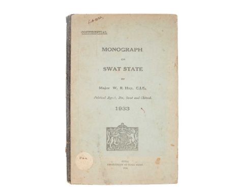
Lot 22
British India (modern Pakistan) Monograph on Swat State, 1933 by Major W. R. Hay, C.I.E., Political Agent, Dir, Swat and Chitral. Simla: Government of India Press, 1934. 8vo, original cloth-backed printed boards, [4] 36 pp., folding lithographic sketch map loose in end-pocket as issued, text-leaves wire-stitched, stitching corroded, title-page, final leaf and conjugate blanks detached, textblock loose in binding, binding worn and marked, ink-stamps and markings of the library of the economic adviser to the government of India, bookplate removed from initial blank, short tear to end-pocket (map unaffected)Note: Note: Marked 'confidential' on the front board, and very rare: the printer's slug at the end of the text suggests that 100 copies were printed. One institutional copy traced, at the British Library; no copies in auction records.

Lot 13
Scotland 16 maps of Scotland and its regions Nouvelle Carte d'Ecosse, ou on fait observer l'Etat de la Noblesse..., 55 x 42.5cm, left margin repaired;Johnson, William. Northern Part of Ayrshire, compiled from estate plans &c. Edinburgh: John Thomson, 1828, 72 x 54.5cm, hand-coloured in outline, some offsetting; [and] Southern Part of Ayrshire, some offsetting;Sanson, Nicholas. Carte Generale des Royaume [sic.] d'Angleterre. Ecosse et Irlande, Paris, 1640 [but probably a later re-strike or copy], 42.5 x 54.5, hand-coloured;Map of Scotland from the latest DIscoveries. London: J. Harrison, 1787, 35 x 54.5cm, crude join to reverse;Cary, John. A New & Correct Map of the South Part of Scotland, from the best Authorities. London: John Stockdale, 1805, 54.5 x 42.5cm, hand-coloured in outline;[Stockdale. Part of Argyll, n.p., n.d., 19th century], 82 x 64cm, hand-coloured; [and] [Part of South-West Scotland, with Arran];Thomson, John. Selkirkshire. Edinburgh, 1824, 73 x 54.5cm, hand-coloured in outline, some light dust-soiling;and 8 others
Lot 72
Glasgow Large collection of works Pagan, James (editor). Sketch of the History of Glasgow. Glasgow: Robert Stuart & Co., 1847. First edition, 8vo, original cloth, engraved additional title-page, folding map, 22 plates (on tinted ground);Idem. Glasgow, Past and Present: illustrated in Dean of Guild Court Reports, and in the Reminiscences and Communications of Senex, Aliquis, J. B., etc. Printed by private subscription. Glasgow: James Macnab [-David Robertson], 1851-6. First edition, 3 volumes in 2, 8vo, original green cloth, engraved frontispiece to volume 3;Marwick, Sir James D. The River Clyde and the Clyde Burghs, the City of Glasgow, and its Old Relations with Rutherglen, Renfrew, Paisley, Dumbarton, Port-Glasgow, Greenock, Rothesay and Irvine. Glasgow: James Maclehose & Sons, 1909. First edition, 4to, original cloth, photogravure portrait frontispiece;Ibid. Early Glasgow. A History of the City of Glasgow from the Earliest Times to the Year 1611. Glasgow: James Maclehose and Sons, 1911. First edition, 4to, original cloth, halftone photographic plates;Renwick, Robert. Glasgow Memorials. Glasgow: James Maclehose and Sons, 1908. First edition, one of 600 copies, 4to, original cloth, halftone photographic plates;Cruikshank, George (illustrator). Midnight Scenes and Social Photographs: being Sketches of Life in the Streets, Wynds, and Dens of the City. By Shadow. Glasgow: Thomas Murray and Son, 1858. First edition, 8vo, original cloth, etched frontispieces (browned and damp-stained), free endpaper removed;[Rutherglen poet]. Hamely Echoes from an Auld Toun. By Hugh Muir. Glasgow: Aird and Coghill, 1899. First edition, 8vo, original blue cloth, all edges gilt, halftone photographic frontispiece and similar plates;Strang, John. Glasgow and its Clubs. London: Richard Griffin and Company, 1856. First edition, 8vo, contemporary green half calf;Campbell, William. History of the Incorporation of Cordiners in Glasgow. Glasgow: Robert Anderson, 1883. First edition, 8vo, original cloth;Crawfurd, George. A Sketch of the Rise and Progress of the Trades' House of Glasgow. Glasgow: Bell and Bain, 1858. First edition, 8vo, original cloth, folding plate;Insch, George Pratt. Carmina Glottiana. Poems of Avondale and Clydeside. Edinburgh: Lindsay & Co., 1928. First edition, 8vo, original cloth;Gibson, John. The History of Glasgow, from the Earliest Accounts to the Present Time. Glasgow: for the author, 1777. First edition, 8vo, contemporary sprinkled calf, worn, joints cracked, lacking map;and approx. 45 others, 19th and first half of the 20th century, including histories of Glasgow parishes, churches, trade organisations, and similar, mainly Glasgow-published, original cloth or wrappers
Lot 52
Mackenzie, Alexander Voyages from Montreal, on the River St. Laurence, through the Continent of North America to the Frozen and Pacific Oceans; in the Years 1789 and 1793. With a Preliminary Account of the Rise, Progress, and Present State of the Fur Trade of that Country. London: for T. Cadell, Jun. and W. Davies, 1801. First edition, 4to (25.6 x 20.5cm), [4] viii cxxxii 412 [2] pp., recent tree calf to style, smooth spine gilt in compartments, decorative gilt border to covers, marbled endpapers, edges dyed yellow, half-title, engraved portrait frontispiece, 3 folding maps, errata leaf, toning, intermittent stains and blemishes to text, maps backed on linen, each with short closed handling tears to inner folds and map of North America with longer tear to foot (all closed up), final map ('Track ... to the Pacific Ocean in 1793') with a few spots, quire d spotted, small spill-burns in o4, G3 and 3E4, r2 (final leaf of preface) chipped along fore edge, B1 (first leaf of main text) repaired and slightly shorter in fore margin (possibly supplied from another copy) [Howes M-133; Sabin 43414]Note: Note: Mackenzie's two journeys, undertaken from Fort Chipewyan on Lake Athabasca on behalf of the fur-trading North West Company, added considerably to the geographical knowledge of the north-west Canadian interior. The first resolved the 'major misunderstanding' (ODNB) that what became known as the Mackenzie River led due west to the Pacific, rather than north to the Arctic Ocean; his second was 'the first journey across North America north of Mexico' (idem).
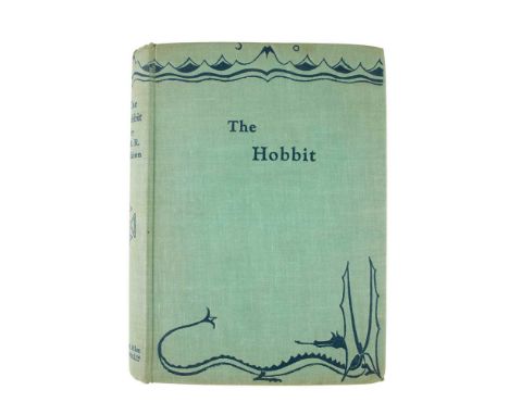
Lot 253
Tolkien, J. R. R. The Hobbit First edition, first impression, one of 1500 copies, 8vo, original green cloth, titles and decoration to spine and covers in blue, top edge dyed green, map endpapers printed in red and black, frontispiece ('The Hill: Hobbiton across the Water'), plate ('Mirkwood'), spine rolled, small area of cockling to head of front board, corners very slightly bumped, lower fore corner of rear board with cloth worn away, a few light finger-marks to margins [Hammond A3a]Note: Provenance: With the ownership inscription 'Betty Jean Orton, Xmas 1937' to the initial blank: this is the daughter of Harold Orton (1898-1975), English dialectologist and lexicographer remembered for his monumental Survey of English Dialects (1962-72).
Lot 39
Middle East and Arabia Four works Tamisier, Maurice. Voyage en Arabie. Séjour dans le Hedjad. Campagne d'Assir. Paris: Louis Desessart, 1840. First edition, 2 volumes, 8vo (20.8 x 12.8cm), [4] 399, [4] 402 pp., contemporary quarter sheep, half-titles, engraved folding map of the Hijaz, spines worn, spine of volume 1 with loss and repair, large section of leather on spine of volume 2 detached (now laid in), contents spotted [Macro, Bibliography of the Arabian Peninsula, 2163]; [Firmin-Didot, Ambroise]. Notes d'un voyage fait dans le Levant en 1816 et 1817. Paris: Firmin Didot, [1826]. First edition, 8vo (20 x 11.8cm), [8] 403 pp., contemporary quarter calf, marbled sides and endpapers, joints cracked, top compartment of spine reattached, spotting to outer leaves and to margins [Blackmer 485; Cobham-Jeffery p. 67]; Buckingham, James Silk. Travels in Palestine, through the Countries of Bashan and Gilead ... including a Visit to the Cities of Geraza and Gamala, in the Decapolis. London: Longman, Hurst, Rees, Orme, and Brown, 1821. First edition, 4to (29 x 22cm), xxv [3] 553 pp., uncut in original boards, engraved portrait frontispiece, folding map, 6 plans, plate of inscriptions, wood-engraved vignette chapter-headings, 4 advertisement leaves of different dimensions tipped to recto of frontispiece, contemporary bookplate of William Foster to front pastedown, front board detached, rear board reattached, spotting to map and plans, map loose; Lucas, Paul. Voyage au Levant. Nouvelle edition revue et corrigée. Paris: Nicolas Simart, 1714. 8vo (15.6 x 9cm), [24] 244 [2] 245-499 [3] pp., 10 engraved plates including natural history subjects and a view of Isfahan, engraved folding map of the Nile, loss to head of spine, light browning, folding map with adhesive staining from attempted tape-repair to closed tear Note: Note: Maurice Tamisier served as secretary to the medical officer of the expeditionary force sent by Muhammad Ali Pasha of Egypt to pacify the Hijaz in 1833-4. His work contains extensive accounts of Jeddah and Taif. Ambroise Firmin-Didot visited Greece, Constantinople and environs, Egypt, Palestine, Syria, modern-day Lebanon, Cyprus and Rhodes. According to Blackmer 'only a few copies' of his work were printed; a projected second part never appeared. Paul Lucas's Voyage au Levant was first published in 1704.Provenance: Guy Abela (1929-2015), Lebanese poet and bibliophile (gilt stamps to foot of spines; ownership inscriptions to half-titles or initial blanks).

Lot 4
Blaeu, Johannes Collection of maps of Scotland, mid 17th century, Amsterdam dimensions generally approx. 60 x 45cm, all hand-coloured, with central folds, comprising:[Clydesdale]. Glottiana praefectura superior. The Upper Ward of Clyds-Dayl. 4 copies, one with repairs and slight marginal loss, one toned, nicked along edges, slightly browned along central fold, with separation and tape-repair at head and foot of fold;[Skye]. Skia vel Skiana. The Yle of Skie. Latin text verso, old repairs and related adhesive-staining to top and bottom edges of central fold;[Kirkcudbright]. Praefectura Kircubriensis ... The Steuartrie of Kircubright;[Galloway]. Gallovidiae pars Media ... The Middle-Part of Galloway;[South Ayrshire]. Carricta Meridionalis. The South Part of Carrick. 4 copies, one with Spanish text verso, the rest Latin, the Spanish toned and with a few small marginal repairs, one Latin map spotted in upper third, one toned, offset, with separation at head and foot of central fold and short closed tear to upper margin, one with toning, offsetting, various nicks and large area of paper-reinforcement verso.Together with: Henricus Hondius, A New Description of the Shyres Lothian and Linlitquo, c.1640, uncoloured, German text on verso
Lot 59
Travel and topography Collection of works, 18th and 19th century Parboni, Achille. Nuova raccolta della principali vedute antiche, e moderne dell'alma citta di Roma et sue vicinanze. Rome: Giacomo Antonelli, 1824. Oblong 8vo, contemporary half morocco, engraved title-page, 99 engraved plates, spotting to front and rear;Parnell, Richard. The Natural History of the Fishes of the Firth of Forth and Tributaries. Private Copy. Edinburgh: Neill and Company, 1838. First edition, presentation copy, inscribed for 'John Stark Esr, with the compliments of the author' on the title-page, 8vo, original purple cloth, 28 etched plates numbered 18-44 (including 33 bis);Sale, Lady Florentia. A Journal of the Disasters in Afghanistan, 1841-2. London: John Murray, 1843. First edition, large 12mo, contemporary calf, 2 lithographic maps (one folding), binding rubbed, old Kelso United Library plate to front pastedown, related inscription to title-page, folding map with loss of one section, laid down, and with splitting along one fold, various chips and tears to text-leaves;Douglas, Francis. A General Description of the East Coast of Scotland from Edinburgh to Cullen. Paisley: printed for the author, 1782. 12mo, 19th-century green half calf, rebacked with original spine laid down, front inner hinge cracked, head of title-page repaired;Pyne, James Baker. Lake Scenery of England. London: Day & Son, c.1860. 4to, original purple cloth gilt, 25 tinted lithographic plates including vignette title-page, gutta percha perishing;and 8 others (these not collated): John Leighton, Scenes in Scotland, 1831, contemporary green calf, engraved plates; G. R. Gleig, The Campaigns of the British Army, Fourth Edition [bound with:] Sale's Brigade in Afghanistan, New Edition, 1836-61, 2 works in 1 volume, contemporary half calf; James Jackson Jarvis, Parisian Sights and French Principles, 1853, contemporary half calf; Alphonse de Lamartine, Visit to the Holy Land, c.1840, 2 volumes, contemporary half calf by William Muir of Hamilton, engraved plates; J. Goldsmith, Geography on a Popular Plan ... Sixth Edition, 1811, contemporary tree sheep, engraved maps and plates (many folding); J. F. Campbell, Popular Tales of the West Highlands, 1860, 4 volumes, contemporary red half morocco gilt; Harriet Beecher Stowe, Sunny Memories of Foreign Lands, 1854, contemporary marbled half calf; Oliver & Boyd's New Edinburgh Almanac, 1848, contemporary red roan gilt
![Survey of Palestine [Map] Palestine 1: 100,000 Compiled, drawn and reproduced by Survey of Palestine, 1942-1944 (mostly 1942)](https://cdn.globalauctionplatform.com/bc80e8b7-d26a-42a0-aa0c-b06900ce413d/f074895e-218f-4b91-86fc-b08300b20784/468x382.jpg)

Lot 8
Indian maps Map of the Island of Bombay constructed on reductions from Colonel Laughton's Map of 1872, with alterations up to July 1874. Poona: 1875, folded linen-backed map, 137 x 78cm, some chipping to edges, significant staining to map [RARE: no copies traced at auction]; Wharton, Captain W.J.L. India - West Coast. Bombay Harbour. London: Published by the Admiralty 14th Jan. 1885, 105 x 68.5cm, some splits and sellotape repairs, small annotation in an early hand
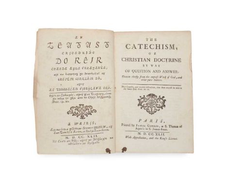
Lot 74
Irish Gaelic printing The Catechism, or Christian Doctrine by way of Question and Answer [Irish title: An teagasg Críosduidhe]. Paris: James Guerin, 1742. First edition, 8vo, contemporary tree sheep (lacking front board), liv 513 pp., parallel text and title-pages in Irish and English, small ink-stain to foot of title-pages, damp-staining to quires R, S and X [ESTC T97298];Mignan, Robert. Travels in Chaldaea, including a Journey from Bussorah to Bagdad, Hillah, and Babylon, performed on Foot in 1827. London: Henry Colburn and Richard Bentley, 1829. First edition, 8vo, xvi 333 [3] pp., advertisement leaf, contemporary purple diced calf gilt, 2 folding maps, 7 aquatint plates [Atabey 908];Hartshorne, Anna C. Japan and her People. Philadelphia: Henry T. Coates & Co., 1902. First edition, 2 volumes, 8vo, original blue pictorial cloth gilt, 50 photographic plates, folding map, bookplates;and 5 othersNote: Note: This Irish catechism, written by the Roman Catholic priest Andrew Donlevy (1680-1746), is 'the most complete formal text in Irish for [its] period and draws on the author's spoken Irish' (ODNB).
Lot 57
Travel Group of 19 Goldberry, Silv. Meinard Xavier. Travels in Africa. London: James Ridgway, 1802. 3 volumes, 12mo, maps and plates, contemporary calf gilt with red morocco gilt labels, folding map cut and bound in two parts;Blagdon, Francis. Modern Discoveries; or, a Collection of Facts and Observations... London: James Ridgway, 1802. Volume 2 only, 12mo, folding map, calf uniform with Goldberry;Roscoe, Thomas. The Tourist in Switzerland and Italy. London: Robert Jennings, 1830. 8vo, 25 plates, contemporary diced calf with later spine;[Lysons, Daniel and Samuel. Magna Britannia - Buckinghamshire. London, 1806.] 4to, Buckinghamshire section only, maps and plates including some hand-coloured, modern half calf;Stanley, Henry M. In Darkest Africa. London: Sampson, Low, Marston, Searle and Rivington, 1890. 6 volumes, 8vo, original red cloth gilt;[Holmes, W.H.] Twenty-Seventh Annual Report of the Bureau of American Ethnology. Washington: Government Printing Office, 1911. 4to, original green cloth gilt;Musgrave, Sir Richard. Memoirs of the Different Rebellions in Ireland. Dublin: John Milliken, 1801. Second edition, 4to, contemporary calf, joints split, many tears and repairs with some loss;and 5 others
![Indian lithographic printing Collection of works, 19th and early 20th century [Indian convict autobiography] Muhammad Jaffer](https://cdn.globalauctionplatform.com/bc80e8b7-d26a-42a0-aa0c-b06900ce413d/5b39ff6c-fdc5-428a-abc7-b07300ca6c70/468x382.jpg)
Lot 33
Indian lithographic printing Collection of works, 19th and early 20th century [Indian convict autobiography] Muhammad Jaffer Thanesari (1838-1905). Tawarikh-i 'Ajib ['Wonderful Stories']. [Place illegible:] Temple Press, 1307 AH [1889/90 CE]. 8vo (24.5 x 15cm), recent half leather, in Urdu (except testimonials in English to verso of title-page), lithographed throughout, [2] 100 pp., map of Port Blair in text (p. 66), browning, tissue-repairs to title-page, worming to head and foot of last few leaves similarly repaired, light marginal worming;Mawlawi Sayyid Muhammad Husayn Aghlab Muhani. Nayrang-i Afghan ['The Charm of the Afghans']. Lucknow: Matba' Sham Oudh, 1904. First edition, 8vo (24 x 14cm), recent half leather, in Urdu, lithographed throughout, [2] 4 8 64 344 5 pp., 2 albumen-print photographic portraits of Abd al-Rahman Khan and Habibullah Khan mounted to leaf after title-page, variable browning, corner of pp. 23/4 detached, closed tear in pp. 225/6;Mawlawi Abu Muhammad 'Abd al-Haqq. History of Palestine. [Urdu title:] Tarikh Bayt al-Muqaddas. Delhi: Mujtabai Press, 1891. 8vo (23.2 x 14cm), recent half leather, in Urdu, lithographed throughout, [2] 40 pp., 3 plates, marginal repair to title-page, small closed tear in final plate;and 6 others, including Mirza Muhammad Jalal al-Din Tabataba'i, Tawqi'at Kisra, Lucknow: Nawal Kishore, c.1858 (Persian literature) and similarNote: Note: Muhammad Jaffer Thanesari was a Wahhabi Muslim activist arrested in 1863 for conspiring to smuggle funds to anti-British mujahideen in Afghanistan. From 1866 to 1883 he was a prisoner at the Port Blair penal colony in the Andaman and Nicobar Islands. Tawarikh-i 'Ajib, an account of his time in prison, is also known under the title Kala Pani. Printed on the verso of the title-page is a testimonial in English from Richard Carnac Temple as cantonment magistrate, Ambala: 'I have known Muhammad Jafir to 10 years, first as a munshi at Port Blair and then as an employe [sic] here under me, whatever may have been his shortcoming in days gone by he seems to have profited by this severe punishment that overtook him and has been as long as I have known him a quiet, inoffensive man [...]'. A date in the colophon suggests that the work may have first been printed in 1887. The second work, Nayrang-i Afghan, appears to be a history of Afghanistan; the author's other works according to a note on the title-page include works on Russia (Kitab-i Rus) and the Islamic schools of law (Haqa'iq-i Madhahib).

Lot 6
Cary, John Cary's New and Accurate Map of London and Westminster, the Borough of Southwark and parts adjacent; viz. Kensington, Chelsea, Islington, Hackney, Walworth, Newington, &c... London: John Cary, [n.d.] Large folding map, 153 x 82cm, hand-coloured, some browning, a few holes to linen at folds, some slight damage to a few panels with a little loss, without case

Lot 18
Thomson, John The Atlas of Scotland, containing Maps of Each County Edinburgh: J. Thomson, 1832. Large folio, hand-coloured double page panorama of Principal Mountains and uncoloured panorama of Principal Rivers, 58 double-page hand-coloured engraved maps, hand-coloured index map, later cloth gilt, title-page repaired, title, prelims and index leaves mounted, a few small repairs to upper margins of maps, a little dampstaining
Lot 56
View books, Baedekers, Scottish interest and miscellaneous Collection of works 11 view books (c.1900, oblong 4to, with plates from photographs, various media, and including: J. J. Riley, Photographic View Album of Southport; T. S. Gowland, Album of Views of Eastbourne, leporello format; H. Owen, Photographic View Album of Barmouth and District; E. J. Oldbury, Picturesque Views of Knighton and Neighbourhood; and similar, including Colwyn Bay, Shrewsbury, Blackpool, etc.); 7 Baedekers (Southern France; Italy ; Spain and Portugal, 2 copies; Central Italy; Rhine; Egypt); John Wilson, Wilson's Guide to Rothesay and the Island of Bute, Rothesay: John Wilson, 1848. 8vo, original red cloth gilt, engraved map frontispiece, vignette title-page, plate; The Stranger's Guide to Edinburgh ... Seventh Edition, Edinburgh: John Moir, 1820, 12mo, later sprinkled half calf, folding map (backed on linen); The Story of the Stewarts, Edinburgh, 1901, 4to, original cloth, inscribed by the author; Henry Herbert & Co (publisher), London (Illustrated), a Complete Guide to the Places of Amusement ... 1879, 4to, original cloth, text printed in purple within decorative chromolithographic border, wood-engraved illustrations, mounted albumen print portrait photographs; Joseph Gostwick, English Poets, Twelve Essays, London: Frederick Bruckmann, 1876 (8vo, original cloth, mounted albumen print portrait photographs from paintings; and approx. 20 others, the lot sold as seen, not subject to return
Lot 86
Scotland Large collection of works on topography and local history Wilson, Daniel. Memorials of Edinburgh in the Olden Time. Edinburgh: Thomas C. Jack, c.1840. 2 volumes, 4to, original green cloth gilt, folding map frontispiece, numerous engraved plates;St John, Charles. A Tour in Sutherlandshire, with Extracts from the Field-Books of a Sportsman and Naturalist. London: John Murray, 1849. First edition, 2 volumes, 8vo, original green pictorial cloth gilt, 10 engraved plates, wear to spine-ends, tissue-guard for frontispiece of volume 1 removed;Mackenzie, Colin. Storm and Sunshine of a Soldier's Life. Edinburgh: David Douglas, 1884. First edition, 2 volumes, 8vo, original blue cloth gilt, engraved portrait frontispiece (pencil-marking to tissue-guard), rubbing to extremities, half-title inscribed in pencil 'Emma A. P. Dawson, from Mrs Colin Mackenzie, 1884', albumen print mounted to verso;Craig, R. S., & Adam Laing. The Hawick Tradition of 1514. Hawick: W. & J. Kennedy, 1898. First edition, 4to, original red cloth, frontispiece, folding map to rear, damp-stain to front board and concomitant bleeding of dye into margins of prelims;Batten, Edmund Chisholm. The Charters of the Priory of Beauly. [Edinburgh]: for the Grampian Club, 1877. First edition, 8vo, original cloth;Penney, John. A Topographical and Historical Account of Linlithgowshire. Edinburgh: Stevenson, 1832. First edition, 8vo, original cloth, engraved additional title-page (dated 1831);Edwards-Moss, John E. A Season in Sutherland. London: Macmillan and Co., 1888. First edition, 8vo, original blue cloth, bookplate of Charles Thomas-Stanford (1858-1932);Sharpe, J. Selkirk: its Church, its School, and its Presbytery. Selkirk: James Lewis, c.1914. First edition, 8vo, original cloth, 4 halftone photographic plates;Mackay, Donald. Memories of our Parish (Parish of Reay, Caithness). Dingwall: Ross-shire Printing & Publishing Co., Ltd., 1925. First edition, 8vo, original cloth, 2 plates, presentation inscription from the author;Horne, John. Summer Days in Cattiland. Wick: office of the "John O'Groat Journal", c.1910. First edition, 8vo, original cloth-backed boards;MacCormick, John. An t-Eilean Muileach. The Island of Mull. Its History, Scenes and Legends. Glasgow: Alex. Maclaren & Sons, 1923. First edition, 8vo, original cloth;Evans, A. H. A Fauna of the Tweed Area. Edinburgh: David Douglas, 1911. First edition, 8vo, plates, bookplates;Tait, E. S. Reid (editor). The Statistical Account of Shetland 1791-1799 ... by Sir John Sinclair. Lerwick: T. & J. Manson, 1925. 4to, original cloth;Metcalfe, William M. A History of the County of Renfrew from the Earliest Times. Paisley: Alexander Gardner, 1905. 4to, original quarter vellum, top edge gilt, others untrimmed, folding map (detached, spotted);Anderson, Joseph (editor). The Orkneying Saga. Edinburgh: Edmonston and Douglas, 1873. 8vo, original cloth, lithographic frontispiece, plates;and approx. 40 others including Edinburgh and provincial Scottish imprints
![Speed, John and Peter Keer [Volume of miniature maps of Scotland and Ireland] [London, c.1650]. Oblong 12mo (10.3 x 15.3cm),](https://cdn.globalauctionplatform.com/bc80e8b7-d26a-42a0-aa0c-b06900ce413d/4216ed2e-c303-431f-a471-b07300caaf8d/468x382.jpg)
Lot 16
Speed, John and Peter Keer [Volume of miniature maps of Scotland and Ireland] [London, c.1650]. Oblong 12mo (10.3 x 15.3cm), modern half calf, 12 engraved maps with text on versos, comprising: 1) The Kingdome of Scotland; 2) The South p[ar]t of Scotland wherin are contayned Edinbrough, St Andrew and Glasco; 3) The Southern parte of Scotland, wherin is ye strange Lake Lomund; 4) The Eastern Part of Scotland wherin ther are divers Shires and the University of Aberdyn; 5) Part of Scotland it is called of the inhabitance Stranaverne with his borderers; 6) The Isles of Hebrides wth ther borderers; 7) Cathanes and Orknay Ins[ulae]; 8) The Kingdome of Irland; 9) Mounster; 10) Linster; 11) Connack; 12) Ulster. Light bronwing, very shallow chip to top edges, 'The South p[ar]t of Scotland with minor loss to lower fore corner, a few marks.Together with: John Cary, [Cary's New map of England and Wales with part of Scotland ... Delineated from Actual Surveys and materially assisted from Authentic Documents liberally supplied by the ... Post Masters General, London: J. Cary, 1794], 4to (30.2 x 24.5cm), contemporary marbled boards, rebacked and recornered, engraved dedication leaf, 14 + 88 pp. letterpress, engraved hand-coloured general map, 'Explanations' leaf (numbered 72), 45 maps hand-coloured in outline, lacking title-page and at least sheet numbers 16, 23-26, 33-6, 40, 43, 51-2, 58, 62-9, sheet 57 loose [ESTC N48119, 9 copies in libraries world-wide].Sold as a collection of maps not subject to return

Lot 10
Orkney and Shetland Collection of engraved maps and charts, 17th to early 19th century Collins, Greenvile. 10 sea charts, c.1693 or later, approx. dimensions 51 x 62cm, all with numerous rhumb lines, several backed on additional sheet of paper apparently at or near date of issue, variable toning, charts comprising: The South Part of the Isles of Shetland (hand-coloured); Part of the Maine Island of Shetland, 2 copies (both hand-coloured, decorative title cartouches); The Islands of Orkney (2 copies, one hand-coloured, decorative title-cartouches, coloured copy with damp-staining along top edge, uncoloured copy browned); The East Coast of Scotland with the Isles of Orkney and Shetland (hand-coloured, reinforced verso along central fold); The Cheife Harbours in the Islands of Orkney (4 copies, each with 2 inset maps and a panel of coastal profiles inset, decorative title cartouches, one hand-coloured);Mackenzie, Murdoch. Carte des îles Orcades et de la côte nord d'Ecosse ... réduite des plans de Mackenzie et publiée par ordre du Contre-Amiral Decrès Ministre de la Marine et des Colonie. Paris: Dépôt général de la Marine, An XII [1803/4]. 63 x 92 cm, rhumb lines, inset map of Shetland and coastal profiles, hand-coloured, central fold;[Bellin, Nicolas]. Carte réduite des isles Britanniques. Quatrième feuille. Partie septentrionale de l'Ecosse, [Paris], 1757. 64 x 92cm, rhumb lines, decorative title cartouche, inset panel of Orkney coastal profiles, central fold;Sanson, Nicolas. Les isles Orcadney ou Orkney; Schetland, ou Hetland; et de Fero, ou Farre, tirées de divers memoires. Paris: Pierre Mariette, 1669. 55 x 72cm, decorative title cartouche, central fold; and 4 others similar
![Fife Collection of works Fraser, Sir William. Memorials of the Family of Wemyss of Wemyss. Edinburgh: [no publisher], 1888. F](https://cdn.globalauctionplatform.com/bc80e8b7-d26a-42a0-aa0c-b06900ce413d/7b5af266-fca6-4acd-9c38-b07300caa995/468x382.jpg)
Lot 71
Fife Collection of works Fraser, Sir William. Memorials of the Family of Wemyss of Wemyss. Edinburgh: [no publisher], 1888. First edition, one of 100 copies (according to other records), 3 volumes, 4to, original red quarter morocco gilt by C. S. Smith of Edinburgh, top edges gilt, others untrimmed, decorative title-pages, 33 colour lithographic plates reproducing original charters, letters and other documents, wood-engraved illustrations of seals and signatures in text, volume 1 with presentation plate to front pastedown, largely effaced but name of recipient William Blackwood Esq. (presumably the famous publisher) visible, volumes 2-3 with bookplates of William Montagu Hay, 10th Marquess of Tweeddale, spines rubbed, peripheral mottling to covers, volume 2 with split to foot of spine;Idem. Illustrations of the Memorials of the Family of Wemyss of Wemyss. Edinburgh: [no publisher], 1888. 2 copies, 4to, both in original red cloth gilt, containing duplicates of the title-pages, colour plates and other illustrations from the Memorials, one copy with bookplate of Innes of Learney to front pastedown and later colour print mounted to front free endpaper, the other with bookplate of Francis James Grant, Rothesay Herald and Lyon Clerk, second copy with wear to spine-ends mottling to covers;Idem. The Melvilles, Earls of Melville, and the Leslies, Earls of Leven. Edinburgh: [colophon:] by T. and A. Constable, at the Edinburgh University Press, 1890. First edition, one of 150 copies, 3 volumes, 4to, original red cloth gilt, rebacked in red morocco, top edges gilt, others untrimmed, 41 plates including photogravures or lithographs from portrait paintings (many on india paper, mounted) and colour lithographic facsimiles of historical documents, printed presentation plate addressed in manuscript to Archibald Stirling of Keir to front pastedown of volume 1;Idem. Introductions and Illustrations in the Melvilles, Earls of Melville and the Leslies, Earls of Leven. Edinburgh: [no publisher], 1890. 2 copies, 4to, both in original red cloth gilt, plates, one copy inscribed by William Fraser to David Chalmers of Redhall (1820-1899), Scottish industrialist, with a letter from Fraser to Chalmers in original envelope mounted to endpaper, and Chalmers's bookplate;Patrick, John (1831-1923). Photographic Views of the Fife Coast, c.1870. 8vo, original green cloth, 13 albumen-print photographs (10.7 x 18cm), on card mounts backed onto continuous sheet of linen folded in leporello format, printed border and captions to mounts, contemporary gift inscription to front pastedown, modern bookplate to rear, light soiling to mounts, ties detached or gone;Fife Tales by Photo. Part I. Contents. I. The Mother's Fault. II. The Gowks. III. The Minstrel. With a Calotype [sic] of Macduff's Castle. Leven: John Patrick, 1861. 12mo, 74 pp., original glazed yellow printed wrappers, albumen-print photographic frontispiece, wrappers chipped and soiled, attempted adhesive-repair to spine, closed tear in index leaf, occasional soiling to contents;Limekilns. Its Antiquities and Church Landowners, Harbours, Ships, Shipmasters and Shipments, and Passagium Reginae. Compiled under the Instructions of the Right Honourable the Lord Wavertree of Delamere. Edinburgh: for private circulations, 1929. First edition, one of 215 copies, large folio, original cloth, 20 plates, front free endpaper excised, pen-marks to endpapers, mark to foot of p. 88;Watson, Charles Brodie Boog. Alexander Cowan of Moray House and Valleyfield (Founder of A. Cowan & Sons), his Kinsfolk and Connections. Perth: D. Leslie (Watson & Annandale), privately printed, 1915. Folio, original cloth, halftone photographic frontispiece from a painting, 2 double-page plates, without genealogical tables listed in contents, inscribed by the author, together with a separate issue of the final part ('Some Notes on Moray House'), folio, original cloth, with plates as in the preceding work, inscribed by the author;Mackay, Aeneas J. G. A History of Fife and Kinross. Edinburgh: William Blackwood and Sons, 1896. First edition, large-paper issue, one of 100 copies, 4to, original black cloth gilt, top edge gilt, others untrimmed, folding map, bookplates (R. Y. Pickering, dated 1895, and the Barons Glenconner);and 4 others including William Gifford of Joppa, An Ancient Seaport on the Shores of the Forth, Dunfermline: Journal Printing Works, 1914Note: Note: John Patrick was originally a baker in his native Buckhaven before becoming a commercial photographer, working first in Kirkcaldy and subsequently Edinburgh; his famous images include a portrait of Thomas Carlyle taken during Carlyle's visit to Kirkcaldy in 1874. No other copy of Fife Tales by Photo traced.
![Dixon, Robert Map of the Colony of New South Wales [and other folding maps] London: J. Cross, 1837. Folding map, 76 x 126cm,](https://cdn.globalauctionplatform.com/bc80e8b7-d26a-42a0-aa0c-b06900ce413d/130f90db-54db-420d-afe5-b07300caa843/468x382.jpg)
Lot 7
Dixon, Robert Map of the Colony of New South Wales [and other folding maps] London: J. Cross, 1837. Folding map, 76 x 126cm, hand-coloured, in original green cloth case with paper label to upper cover, a little browning and a few small stains in places, some rubbing and staining to case and label;Wyld, James (publisher). A new map of the Country twenty-five miles round London. London: James Wyld, [n.d.] Folding map on four sheets, each 56.5 x 67cm, hand-coloured, in original purple cloth case with paper label to upper cover;Bartholemew, John. Thacker's Reduced Survey Map of India. Calcutta: Thacker, Spink & Co., 1914. Folding map in original blue cloth; with separate index volume;Baker, Benjamin. [Kent]. London, [n.d,] a partial (sheet vi only?) folding map of the county of Kent, 97 x 65cm
![Parry, Edward and others [Voyages, abridged] Journal of a Voyage of Discovery to the Arctic Regions. London: Richard Phillips](https://cdn.globalauctionplatform.com/bc80e8b7-d26a-42a0-aa0c-b06900ce413d/b9bf1f8e-d452-4733-a468-b08100d1d63e/468x382.jpg)
Lot 53
Parry, Edward and others [Voyages, abridged] Journal of a Voyage of Discovery to the Arctic Regions. London: Richard Phillips, [n.d.] 8vo, folding map, 3 plates; [bound with] Prior, James. Narrative of a Voyage in the Indian Seas... London: Richard Phillips, [n.d.] 8vo, folding map, map, 2 plates; [bound with] Dupin, Charles. Narratives of Two Excursions to the Ports of England, Scotland, and Ireland, in 1816, 1817, and 1818. London: Richard Phillips, [n.d.] 8vo, hand-coloured plate, folding map; [bound with] Chateauvieux, Frederick Lillin de. Travels in Italy... London: Richard Phillips, [n.d.] 8vo, 2 plates including one folding aquatint; [bound with] Forbin, Count. Travels in Greece, Turkey and the Holy Land, in 1817-18. London: Richard Phillips, [n.d.] 8vo, 6 plates; [bound with] Analyses of New Works of Voyages and Travels, published during the last Six Months in Great Britain. London: Richard Phillips, [n.d.] 8vo;[volume 2:] de Forbin, Count. Travels in Egypt. London: Richard Phillips, [n.d.] 8vo, folding aquatint plate and 6 others; [bound with] McKeevor, Thomas. A Voyage to Hudson's Bay, during the Summer of 1812. London: Richard Phillips, 1819. 8vo; [bound with] Freminville, Chevalier de la Poix de. Voyage to the North Pole. London: Richard Phillips, 1819. 8vo, 8 plates; [bound with] Queene, J.S. Narrative of thirty-four years Slavery and Travels in Africa. London: Richard Phillips, 1819. 8vo, frontispiece; [bound with] May, R. de. Narrative of the Sufferings and Adventures of Hendrick Portenger... London: Richard Phillips, 1819. 8vo; [bound with] Travels of M. Burckhardt in Egypt and Nubia. London: Richard Phillips, 1819. 8vo; [bound with] Prior, James. Voyage along the Eastern Coast of Africa to Mozambique, Johanna, and Quiloa; to St Helena... London: Richard Phillips, 1819. 8vo, plate, 2 folding maps; [bound with] Cordova, Admiral Don A. A Voyage of Discovery to the Strait of Magellan. London: Richard Phillips, 1819. 8vo, portrait, folding map; [bound with] Waller, John Augustine. A Voyage in the West Indies... London: Richard Phillips, 1820. 8vo, 6 plates, map; 2 volumes, 8vo, contemporary half calf, bindings worn, bookplates of Klingelheofer
![Blaeu, Johannes Le Theatre du Monde, ou Nouvel Atlas, cinquieme partie [Scotland and Ireland] Amsterdam: Johannes Blaeu, 1654](https://cdn.globalauctionplatform.com/bc80e8b7-d26a-42a0-aa0c-b06900ce413d/67f5f306-ccd7-4050-a1f5-b07300ca95d6/468x382.jpg)
Lot 3
Blaeu, Johannes Le Theatre du Monde, ou Nouvel Atlas, cinquieme partie [Scotland and Ireland] Amsterdam: Johannes Blaeu, 1654. Folio (50 x 33cm), [12] 181, 59 pp (rectos of map-sheets not counted in pagination), contemporary mottled calf, gilt spine, engraved architectonic title-page incorporating arms of Scotland and with letterpress title in French on mounted slip, 55 engraved maps (all but one double-page), containing titles within decorative cartouches, several maps additionally with dedication and mileage charts in similar cartouches (a few dedications also incorporating arms of the dedicatee), maps and title-page with contemporary hand-colour throughout, title-page additionally heightened in gilt, woodcut initials and tailpieces, binding pitted, variable browning and offsetting, occasional spotting, small worm-track to lower margin from front to p. 40 (text and maps never affected), repaired closed tears to text-leaf *1 and map of Lennox ('Levinia'), 'Scotia Regnum' map with old circular stain to upper margin, Lower Clydesdale ('Gottiana Praefectura Inferior') map with Dutch text verso and small hole in image [Skelton 59a; cf. Chubb, 'The Atlases of Scotland' II-III, Dutch and Latin editions]Note: Note: 'The first printed atlas of Scotland' (Skelton), being the fifth volume of Blaeu's 1654 world atlas, this copy from the French-text edition: editions with text in French, Latin, Dutch and German were all published in the same year, with a Spanish edition appearing in 1659; the maps themselves are titled in Latin and English. The work contains 'three general maps and forty-six maps of Scottish counties and regions, engraved at Amsterdam from drawings by Robert Gordon of Straloch (1580-1661) and his son James (c.1615-1686), minister of Rothiemay in Banffshire, together with a general map of Ireland and five maps of Irish provinces, after Mercator and Jansson. The maps by the Gordons incorporate the results of the earliest topographical survey of Scotland, that made by Timothy Pont at undetermined dates, apparently within the last two decades of the 16th and the first decade of the 17th century' (ibid.).
![Scotland Collection of engraved maps, 17th and 18th century [Blaeu, William Janszoon]. Scotia Regnum. Amsterdam, c.1650. 50 x](https://cdn.globalauctionplatform.com/bc80e8b7-d26a-42a0-aa0c-b06900ce413d/bab38b11-83d0-4050-a005-b0830160be50/468x382.jpg)
Lot 12
Scotland Collection of engraved maps, 17th and 18th century [Blaeu, William Janszoon]. Scotia Regnum. Amsterdam, c.1650. 50 x 59.5cm, German text on verso, a few closed tears, old repairs;Wit, Frederik de. Scotia Regnum. [Amsterdam], c.1690. 2 copies: one 61 x 93cm, hand-coloured in outline, with letterpress tables conjoined to sides, browning, light soiling, small repair to foot; the other 61 x 52cm, without the conjoined letterpress tables, hand-coloured, somewhat browned, old paper reinforcement along left edge;Kitchin, Thomas. North Britain or Scotland divided into its Counties. London: William Faden, 1778. 77 x 62.5cm, hand-coloured, decorative title cartouche, old linen reinforcement to head and foot of central fold verso;Idem. A New and Complete Map of Scotland and Islands thereto belonging. London, c.1775. 2 sheets, each approx. 62 x 105 cm, hand-coloured in outline, large decorative cartouche and inset map of Shetland, south sheet with old repairs verso;Allard, Carel. Novissima Regni Scotiae Septentrionalis et Meridionalis Tabula. Amsterdam, c.1700. 53.5 x 62cm, hand-coloured, decorative title and dedication cartouches, toning;Homann, Johann Baptist. Magnae Britanniae Pars Septentrionalis. Nuremberg, c.1720. 63 x 53cm, hand-coloured, decorative title and mileage cartouches, toning;Visscher, Nicolaus. Exactissima Regni Scotiae Tabula. [Amsterdam:] P. Schenk Junior, c.1720. 63 x 53cm, hand-coloured, decorative title and mileage cartouches, toning, repairs;Bowles, Carrington. Bowles's New Pocket Map of Scotland. London, 1788. 68 x 54cm, hand-coloured, spotting along edges;Johnston, Alexander. A New Map of the North [South] Part of Scotland, c.1720. 2 sheets, each 39 x 47cm;and 9 others, including duplicates of the south sheets of Kitchin's New and Complete Map, the north sheet of Johnston's map (hand-coloured), 2 maps by Pazzini Carli, 1795, and similar
Lot 60
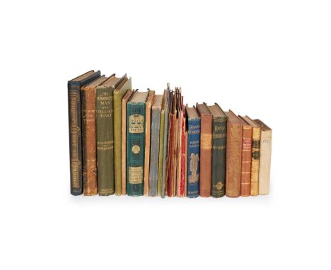
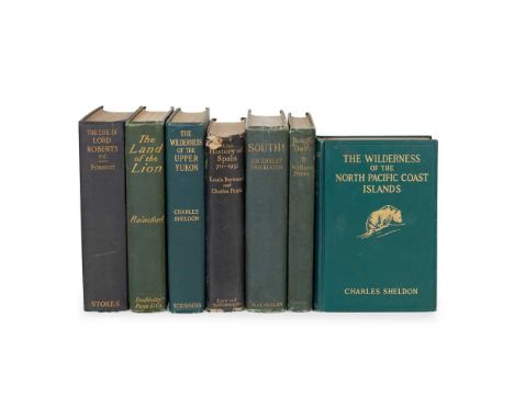
Travel Collection of works Shackleton, Ernest H. South. New York: The Macmillan Company, 1920. First US edition, 8vo, original green cloth, all plates and maps as called for, wear to head and foot of spine, front inner hinge tender;Patterson, J. H. The Man-Eaters of Tsavo and Other East African Adventures. With a Foreword by Frederick Courteney Selous. London: Macmillan and Co., Limited, 1908. First edition, 8vo, original pictorial cloth gilt, photographic frontispiece, map to rear, photographic illustrations throughout the text, contemporary ownership inscription to title-page;Selous, Frederick Courteney. Sport and Travel, East and West. London: Longmans, Green, and Co., 1900. First edition, 8vo, original green cloth, 18 plates;Roosevelt, Theodore. Through the Brazilian Wilderness. New York: Charles Scribner's Sons, 1914. First edition, 8vo, original cloth, all plates and maps as called for, spine sunned and with fraying to head;and 12 others, including Theodore Roosevelt, African Game Trails, reprint, c.1910 (original pictorial cloth), Charles Sheldon, The Wilderness of the Upper Yukon, 1911 (original cloth), W. S. Rainsford, The Land of the Lion, 1909, Lord Roberts, Forty-One Years in India, 1898 (2 volumes, original cloth), William T. Hornaday, Camp-Fires on Desert and Lava, 1908 (original cloth), and similar


-
109182 item(s)/page