We found 109182 price guide item(s) matching your search

Refine your search

Year

Filter by Price Range
  • List
  • Grid
  • 109182 item(s)
    /page

Lot 92

Speed (John).Cumberland and the Ancient Citie Carlile Described with many Memorable Antiquities Therein Found Observed.J. Sudbury and Georg. Humble, 1610 [1611 or later], hand-coloured engraved map, plate mark 387mm x 510mm, English text on reverse (pages 87/88, signature X2), closed tear to left border, framed, glazed front and rear;idem, Merionethshire Described.Georg. Humble, 1610 [1611 or later], hand-coloured engraved map, plate mark 385mm x 511mm, English text on reverse (pages 117/118, signature Qqq), some staining, framed, glazed front and rear (rear cracked) (2)

Lot 88

Ordnance Survey of Yorkshire.The County of Yorkshire on forty-five numbered sheets.Each sheet 303mm x 455mm, card backed, no scales, titles or borders present to allow larger maps to be composed. Complete with large folding index map titled ‘…Combined Index shewing Civil Parishes and the Ordnance Survey Maps of the North Riding of Yorkshire, 1 inch, 3 inch and 25 inch scales, resurveyed 1888-93 … published 1897’. This linen-backed index map has been neatly extended to cover the whole of Yorkshire and all 45 maps are shown. Clean maps preserved in metal case.

Lot 103

Powell-Cotton (P.H.G.).A Sporting Trip Through Abyssinia. A Narrative of a Nine Months' Journey from the Plains of the Hawash to the Snows of Simien, with a Description of the Game, from Elephant to Ibex, and Notes on the Manners and Customs of the Natives.Rowland Ward, 1902, first edition, xxiii, [1], 531 pages, 12 advert pages, frontis, text illustrations including nine 'plates' within pagination, folding map in rear pocket, foxing to preliminary leaves and closed edges, zebra patterned endpapers, original cloth with gilt lettering to spine and upper board (cloth faded, particularly spine). [Czech p. 133]

Lot 97

Senex (John).Ireland, Corrected from the Latest Observations. Divided into its Provinces, Counties and Baronies. Shewing the Principal Roads and the Distances of Places, in Common reputed Miles, by Inspection, Where Barracks are Erected, &c.John Senex (at The Globe against St. Dunstans Church), 1712 [or slightly later], large hand-coloured engraved map, approx 970mm x 675mm, restoration to corners, mounted, framed and glazed.

Lot 87

Skaife (Robert H.). Plan of the Roman, Mediaeval & Modern York. York: John Sampson, 1864, hand-coloured, linen-backed folding map, lithographed by Day & Son, 730mm x 950mm, nine sections, linen splitting at folds, roan gilt boards (worn and detached); Ordnance Survey, Ordnance Survey of York. Southampton: 1852, twenty-one large hand-coloured double-page sheets, 666mm x 980mm, dust marked, worn half calf. (2) [Hugh Murray Collection]

Lot 163

"The Howard Vincent map of The British Empire", 53cm x 61cm, maple veneer frame

Lot 403

Louis Vuitton, a monogram Agenda PM with inserts, designed with the maker's monogram coated canvas exterior, gold-tone hardware, press stud fastening, cross-grain leather lined interior, central ring binder, three card slots, and two slip pockets, together with a ruler, two fold-out map insets, and a sticker sheet insert, measuring 1 by 10.5 by 14.5cm- Overall very good condition- No obvious marks or wear to the coated canvas exterior or interior lining- 8 small stickers missing from the sticker sheet- Serial number SP1005 (October 2005 France)- Without maker's dust bag - Condition reports are a guide only and clients are advised to view items before bidding- For enquiries about this lot please contact Sophie Higgs at sophie@kinghamsauctioneers.com

Lot 120

Selby & Goole Railway 6" Ordnance map, 6" to 1 mile, line backed, 81 x 220cm

Lot 77

An early coloured map of Devonshire by Bloom together with nine other coloured maps

Lot 74

A coloured map of North Wales together with two maps of Devonshire and another the roads from Exeter to Dorchester

Lot 76

An early large unframed coloured map of Portugal together with six other unframed coloured maps of Portugal

Lot 119

17th c. hand coloured map of GVINEE (Guinea) by Pierre Duval, 4" x 5"

Lot 259

Antiquarian books: "The History of the Peloponnesian War" by William Smith A.M. 1781, leather bound with map, and "The Confession of Faith together with the larger and shorter Catechisms" The Fifth Edition 1717

Lot 248

The Family Devotional Bible with map, leatherbound

Lot 188

A military map case with belt, entrenching tool and belt. [W]

Lot 152

WW2. Code AF Foldex Europe, Air, 1/500, 000 Map. Published by Directorate of Military Survey. War Office 1944. Showing Signs of Age. Good condition. We combine postage on multiple winning lots and can ship worldwide. UK postage from £5.99, EU from £7.99, Rest of World from £10.

Lot 1172

Six Frame Tiles, making a map of 'Sicilia', with many landmarks names; Roy Barrett signed limited edition print 'A Way of Life' and a further print in gilt framed. (3)

Lot 1559

Christine Worswick 'Snake Inn' and 'Ladybower Inn' Sepia Prints, signed, 14 x 20. Derrick Wan 'Eyam' signed print. three Ladybower Dam prints, three Derbyshire maps, Cross in Eyam engraving, Peak District map.

Lot 1413

Robert Morden ' Darbyshire'. XVIII Century map, hand coloured 35.5 x 42cm.No visible tears or restoration, small undulation, possible minor foxing

Lot 1430

An XVII Century Christopher Saxton and John Speede Black and White Map of Kingdoem of England (damaged), framed and glazed40.5 x 52.5cm.

Lot 364

A 1942 US Government War Stamps Bonds poster "Even a little can help a lot - NOW", together with a "War in Europe Dated Events, Keep up-to-date, buy more bonds, win the War in 1944" map, a "Ford, Building Wings and Wheels for Victory. Buy Defense Bonds Where You Work" card and a "War Insignia Stamp Album and stamps, poster 50 cm x 35 cm

Lot 1111

A quantity of cast metal toy soldiers and cavalry together with a printed map titled Battle of Wagram 5-6 July 1809, Scotty Bowden and Charlie Tarbox, 1980, in a wooden box, together with a group of similar diorama figurines, etc

Lot 1443

Nigel Houldsworth (Contemporary) "Fisherman's Map of Salmon Pools on the River Tweed" together with "Fisherman's Map of Salmon Pools on the River Tay", in ebonised frames under glass, 85 cm x 26 cm overall

Lot 256

The Times War Atlas, being a folio of Great War maps with gazetteer, 48 cm x 34 cm, together with "Daily Sketch War map of Europe and the Mediterranean", circa 1939

Lot 1352

A 1950s large school type wall map of Australia (Political) by W & A K Johnston of Edinburgh and London, printed, laid on canvas and rolled with wooden rods, 90 cm x 130 cm

Lot 1351

A 1950s large school type wall map of Australia (Political) by W & A K Johnston of Edinburgh and London, printed, laid on canvas and rolled with wooden rods, 90 cm x 130 cm

Lot 1431

An Ordnance Survey map of Carlisle detailing Citadel Station and the County Gaol, surveyed in 1865 by Captain E R James, watercolour tinted engraving, in gilt slip and moulded frame under glass, 107 cm x 72 cm overall

Lot 298

A retro 20th century circa 1970s mahogany & brass bound Campaign style low occasional coffee table. The table having a glass top with a copy of the first world map design in chrome metallic toner. Raised on straight supports with brass inlays. Measures approx. 38cm x 102cm x 61cm.

Lot 198

Chad Valley - a mid century vintage childrens' desk top globe map of the world. The globe mounted upon triangular stand marked 'Chad Valley - By Appointment Toy Makers to Her Majesty Queen Elizabeth the Queen Mother - Made In England', on circular weighted base. Measures approx. 29cm tall.

Lot 465

A collection of local interest books on the subject of Devon including Tiverton, Tavistock, Newton Abbot, Exeter, a vintage Ordnance Survey map of Barnstaple etc

Lot 478

A large framed map of the world dated 1983

Lot 152

A Letts's bicycling map of England & Wales dated 1883 along with W Faden map of Great Britain (to accompany Paterson's book of the roads) and an ABC of Southern locomotives

Lot 155

A vintage "Souvenir of Egypt" lighter in the form of a map of Africa along with a small iron cross with feint writing (name?) and dated 1915

Lot 161

An 18th century etched map of the the holy lands with numerous biblical extracts and etchings of religious sites, prospect of Jerusalem etc. dated Jan 30th 1773. Some damage as shown.

Lot 312

Frankreich - Paris - - 10 Jours à Paris(Deckeltitel). 7 mehrfach gefalt. farbig lithogr. Tafeln (je ca. 17,5 x 85 cm). Paris, Chez Baudot, ca. 1900. 7 Leporellotafeln. Or.-Ppbd. Mit Deckeltitel. Außerordentlich seltenes Ansichtenwerk, nicht im KVK, nicht im Handel nachweisbar. - Mit 11 Promenaden (Rundgängen) durch Paris und 1 Plan. Jeweils übereinander dargestellt der Hin- und Rückweg mit Abbildung und Bezeichnung der Gebäude und Sehenswürdigkeiten der jeweiligen Route. Hinterdeckel mit Werbung der Automobilfirma Bégot & Cail (existierte von 1900-1902). Exceptionally rare work of views, not in the KVK, not in trade. - With 11 promenades (tours) through Paris and 1 map. The outward and return routes are shown one above the other, with illustrations and names of the buildings and sights on each route. Back cover with advertisement of the automobile company Bégot & Cail (existed from 1900-1902).

Lot 604

Astronomie - - Philipp Fauth. Unser Mond. Wie man ihn lesen sollte. Neues Handbuch für Forscher nach Erfahrungen aus 52 Jahren Beobachtung. Publikation VII seiner Sternwarte. Mit 16 Tafeln und einer gefalteten Übersichtskarte in 6 Blättern. Leipzig, Koehler & Ameland, 1936. 592 S. Gr.-8°. Blaue OLwd. mit silbergepr. Titel auf Rücken und Deckel (fleckig). Selten. - Die Karte in 6 gefalteten Teilen in lose beiliegendem Umschlag mit DTitel: "Übersichtskarte des Mondes in 6 Blättern für die Namen und die genauen Örter nach der Internationalen astronomischen Vereinigung und der Map of the Moon (1935)." - "F.s glühende Begeisterung für die Astronomie, seine einzigartige Sehtüchtigkeit (...) ließen ihn zu überragenden Leistungen auf dem Gebiet der Mond- und Planetenforschung gelangen. Diese wurden gewürdigt durch finanzielle Unterstützung seiner Publikationen durch die Berliner und Münchener Akademien der Wissenschaften wie 1937 durch die Verleihung des Titels Professor. 1932 wurde ein Mondkrater offiziell mit seinem Namen bezeichnet. Sein großes Mondbuch (...) sicherte der deutschen Wissenschaft auf lange Zeit die Führung auf dem Gebiet der Mondforschung." (NDB 5, S. 35f.) - Sowohl auf dem Titelblatt als auch auf dem Umschlag der Karte ist der Verlag Eschenhagen in Breslau überklebt und mit dem des Leipziger Verlegers ersetzt. - Sehr gutes Exemplar. Astronomy - With 16 plates and a folded general map in 6 sheets. Blue orig. cloth with silver-stamped title on spine and cover (soiled). - Rare. - The map in 6 folded parts in loosely enclosed envelope with cover title: "General Map of the Moon in 6 Sheets for the Names and Exact Locations According to the International Astronomical Union and the 'Map of the Moon' (1935)." - Both on the title page and on the cover of the envelope the publisher Eschenhagen in Breslau is pasted over and replaced with that of the Leipzig publisher. - Very good copy.

Lot 392

Südamerika - Brasilien - - Hermann Burmeister. Reise nach Brasilien, durch die Provinzen von Rio des Janeiro und Minas geraes. Reisebeschreibung u. Atlas in 2 Bden. Mit 1 gefalt. Karte u. 11 getönten Lithographien. Berlin, Reimer, 1853. VII, 608 S. 8° (Text) u. Quer-Folio (Atlas). HLdr. d. Zt. mit goldgepr. RTitel (berieben, etw. fleckig u. bestoßen) u. mod. marmor. HLwd. mit RSchild Erste Ausgabe mit dem seltenen Atlas. - Sabin 9346. - Henze I, 409ff. - Der Atlas enthält 13 Ansichten auf 10 Tafeln u. 4 indigene Portraits auf 1 Tafel. - Karte in Segmenten auf Lwd. aufgezogen - Kl. bezeichnete Bleistiftzeichnung "Der Corcovado bei Rio de Janeiro" beiliegend. - 1856 dat. Besitzeintrag von Heinrich Burmeister, beide Tle. durchgehend etw. stockfleckig. South America - Brazil - First edition with the rare atlas. Travel description and atlas in 2 volumes. With 1 fold. map and 11 toned lithographs with 13 views on 10 plates and 4 indigenous portraits on 1 plate. Contemp. half leather with gilt stamped title to spine (rubbed, somewhat stained and bumped) and mod. marbled half cloth with label to spine. - Map in segments mounted on canvas. - Small inscribed pencil drawing "Der Corcovado bei Rio de Janeiro" included. - Ownership entry by Heinrich Burmeister dated 1856, both parts somewhat foxed throughout.

Lot 337

Italien - Toskana - - Francesco Fontani. Viaggio Pittorico della Toscana. 6 Bde. Mit gestoch. Porträtfrontispiz u. 211 Kupfertafeln, darunter 4 topographische Pläne. Florenz, Giovanni Marenigh, 1822. 12°. Einheitlich je Pp. d. Zt. je mit etw. spät. mont. RSchild. u. Musterpapierbezug (gebräunt, die Rücken etw. stärker, RSchilder mit kl. Defekten). Dritte Auflage. - Mit einem Porträt des Autors als Frontispiz. - Die Kupfer zeigen versch. Ansichten und Bauten wie den Palazzo Pitti, die Kirche Santa Maria Novella und den Dom von Florenz sowie weitere zahlreiche Ansichten und architektonische Ansichten toskanischer Städte. Mit einer gefalt. Karte der Toskana u. 4 Stadtplänen: Florenz, Siena, Pisa und Livorno. - Papierbedingt im Blattrand sehr zart gebräunt, bis auf Bd. V je etw. wurmspurig (Bd. III etw. stärker betroffen), die Schäden tls. hinterlegt. Bd. V u. VI etw. stockfleckig bzw. wasserrandig (Papier leicht gewellt). Insgesamt wohlerhaltene u. vollständige Exemplare, die filigranen Kupfertafeln mit ausgeprägter Kontrastwirkung. Italy - Tuscany - 6 vols. With engraved portrait frontispiece and 211 copper engraved plates. Uniformly bound, each cont. cardboard with somewhat later mounted labels on spine and patterned paper cover (slightly browned, the spines a bit stronger affected, labels with small defects). - Third edition. - The engravings show various views and buildings such as the Palazzo Pitti, the church Santa Maria Novella and the Dome of Florence as well as other numerous views of Tuscan cities. With a folded map of Tuscany and 4 city maps: Florence, Siena, Pisa and Livorno. - Due to paper very delicately browned in the margins, except for vol. V each somewhat worm-marked (vol. III slightly more affected), the damages partly backed. Vol. V and VI somewhat foxed and waterstained (paper slightly wavy). Overall well preserved and complete copies, the filigree copper plates high in contrast.

Lot 255

Afrika - Ägypten - - Karl Werner. Nilbilder. Vier und zwanzig Facsimiles nach Aquarellen. Naturaufnahmen während zweier Orientreisen 1862 und 1865. Erläuternde Texte von A.E. Brehm u. J. Dümichen. Mit 24 chromolithogr. Tafeln u. 1 Karte. Wandsbeck, Seitz, 1881. Titel in Rot u. Schwarz, 81 S. Folio. 12 Lieferungen in 6 illustr. Umschlägen (am Innenfalz verstärkt) in spät. HLwd.-Mappe mit mont. DTitel. Kainbacher I, 145. - Vgl. Ibrahim-Hilmy II, 324. - "Pantographie-Ausgabe" mit prachtvollen Tafeln (zu diesem von Seitz entwickelten Verfahren vgl. Ries, S. 290, Anm. 1). - Karl Werner reiste bis Nubien. Nach seinen unterwegs gemalten Aquarellen enstand die Folge der farbfrischen Chromolithographien mit schönen Ansichten von Kairo bis Philae. Gezeigt werden u.a.: Kairo von der Nordseite, Chalifengräber, Pyramiden von Giseh, Nilufer, Barbierladen, Tempel etc. - Text papierbedingt leicht gebräunt, Taf. tls. (meist im vollen w. Rand) etw. stockfleckig, vereinzelt geringe Läsuren im Rand. Africa - Egypt - 24 facsimiles after watercolours during two journeys to the Orient in 1862 and 1865. With 24 chromolithogr. plates and 1 map. 12 deliveries in 6 illustr. wrappers (reinforced at the inner fold) in later half cloth folder with mounted title to cover. - "Pantography edition" with magnificent plates (on this method developed by Seitz, cf. Ries, p. 290, note 1). - The series of freshly coloured chromolithographs with beautiful views from Cairo to Philae came about after the watercolors he painted on the way. Shown are among others: Cairo from the north side, caliph tombs, pyramids of Giseh, bank of the Nile, barber shop, temple etc. - Text slightly browned due to paper, plates partially (mostly in the full white margin) somewhat foxed, occ. minor defects in the margins.

Lot 404

A. J. von Krusenstern. Reise um die Welt in den Jahren 1803, 1804, 1805 und 1806 auf Befehl Seiner Kaiserl. Majestät Alexanders des Ersten auf den Schiffen Nadeshda und Newa... 2 Bde in 3. Mit 1 Frontispiz-Porträt (von 3), 11 gefalt. gestoch. Tafeln und 1 grenzkol. mehrfach gefalt. gestoch. Karte. Berlin Haude u. Spener 1811-1812. XLII, 450 S., 1 Bl., 294 S., 1 Bl., 8 S., VIII, 269 S. 4 Bl. 12°. Pp. d. Zt. mit mont. goldgepr. RSchild (beschabt, berieben u. bestoßen, etw. knickspurig, die Rücken leicht verfärbt). Du Rietz 691. - Forbes I 421 u. 407. - Henze III 85ff. - Die Zweite rechtmäßige mit Bewilligung des Verfassers veranstaltete und mit dessen Bildnis gezierte wörtlich nach dem Original gedruckte Ausgabe. - Bedeutender Bericht über die erste russische Weltumsegelung. - Vorliegende Ausgabe enthält den gesamten Reisebericht der Quart-Ausgabe St. Petersburg 1810, lediglich die naturhistorischen Abhandlungen (Bd. 3 der EA) wurden hier nicht abgedruckt. - Adam Johann (Iwan Fjodorowitsch) Krusenstern russischer Reisender deutscher Abstammung wurde von Zar Alexander I. mit der Führung der ersten russischen Weltumsegelung betraut deren Zweck es war, die Nordwestküste des damals russischen Alaska zu erforschen und Handelsbeziehungen mit China und Japan in die Wege zu leiten. Im August 1803 stach Krusenstern in Kronstadt auf der "Nadeshda" in See. Er segelte um das Kap Horn in die Südsee lief Hawaii an und machte eine Aufnahme der Marquesasinseln. Weiter erforschte er die Westüste der japanischen Insel Hokkaido die Ostküste von Kamtschatka und Sachalin sowie die Kurilen und Aleuten. - Mit den 4 Bll. Verlagsanzeigen in Bd. 3 die nicht allen Exemplaren beigegeben wurden (s. hierzu Forbes 1 421. Du Rietz zählt die unnum. Bll. zur Paginierung und führt somit fälschlich 278 S. auf). - Die beiden Frontispiz-Porträts der zweiten Abteilung als Nachdruck eingebunden. Bibliotheksexemplare (Titelbl. je gestempelt), die Vorsätze etw. leimschattig. Insgesamt äußerst saubere und wohlerhaltene Exemplare mit kontraststark, detaillierten Tafeln. 2 vols. in 3. With 1 frontispiece portrait (of 3), 11 fold. engraved plates and 1 border col. folded engraved map. Cont. cardboard bindings with mounted gilt label on spine (scuffed, rubbed and bumped, somewhat creased, the spines slightly discoloured). - Second edition, published with the permission of the author and adorned with his portrait. - Important report on the first Russian circumnavigation. - With the 4 ll. Publisher's advertisements in Vol. 3 which were not included in all copies (see Forbes I 421. Du Rietz counts the unnumbered leaves for pagination and thus incorrectly lists 278 pages). - The two frontispiece portraits of the second section bound in as reprints. Library copies (title page each stamped), the endpapers somewhat glue-shaded. Altogether very clean and well-preserved copies with high-contrast, detailed plates.

Lot 395

Syrien und Palästina - - C.W.M. van de Velde. Reise durch Syrien und Palästina in den Jahren 1851 und 1852. 2 Teile in 1 Bd. Mit 2 farblith. Frontispizen, 2 gefalt. lith. Karten u. 1 gefalt. lith. Schrifttafel. Leipzig, T.O. Weigel, 1855/56. VIII, 337 S., VIII, 422 S. 8°. OLeinen mit ornamental gepr. Deckeln u. goldgepr. DTitel (minimal berieben u. bestoßen, Rücken erneuert, Kopfschnitt etw. angestaubt). Erste deutsche Ausgabe. - Tobler 243 - Henze V, 389f. - Röhricht 449 - Eutiner Landesbibliothek 1431. - Sehr selten im Originalleinen, wie hier vorliegend. - Van de Velde arbeitete 1851-52 als Geograph und Topograph in Syrien und Palästina, wo er für den kartographischen Verlag Perthes eine Karte von Palästina aufnahm. Er berichtet hier in Briefform über seine Reisen in bis dahin teilweise noch unbekannte Gebiete. - Papierbedingt im Blattrand zart u. gleichmäßig gebräunt, Vorsätze erneuert, Frontispize u. Karten etw. braunfleckig, 1 Karte mit etw. laienhaft restauriertem Einriss. Insgesamt wohlerhaltenes u. sauberes Exemplar, selten im OEinband. Syria and Palestine - 2 parts in 1 vol. With 2 colourlithogr. frontispieces, 2 folded lith. maps a. 1 folded lith. prehistoric tablet. Orig cloth binding with ornamental embossed covers, gilt title on front cover (minimally rubbed a. bumped, spine restored, head edges somewhat dusty). - Very rare in the original cloth binding. - Due to paper delicately and evenly browned in the margins, endpapers renewed, frontispieces and maps somewhat brownspotted, 1 map with a slightly amateurishly restored tear. Altogether well preserved and clean copy in the original cloth binding.

Lot 416

Hamburg - - Ganz Hamburg und seine Umgebungen für Sechzehn Schilling. Mit zwei mehrfach gefalteten lithographierten und kol. Karten. Hamburg, F.H. Nestler und Melle, 1842. 2 Bll., 95 S., 6 S. 12°. OPpbd. (bestoßen und beschabt, fleckig, Rücken mit Defekten). Enthält die Beschreibung der Feuersbrunst vom 5.-8. Mai 1842 und die dadurch entstandenen Veränderungen, einem Plan der Stadt mit Bezeichnung der Brandstätte und einer Karte vom Hamburger Grenzgebiet entworfen von F. W. Hanemann. - Papierbedingt sehr gleichmäßig gebräunt, einige Bll. minimal braunfleckig. Die Karten in den Rändern knickspurig und mit kleinen Einrissen, ansonsten ordentlicher Zustand. With two multiple folded litographed and colored maps of Hamburg and its surroundings. Original cardboard binding (bumped and chafed, stained, spine with defects). - Contains the description of the fire of May 5-8, 1842 and the resulting changes, a plan of the city with designation of the fire site and a map of the Hamburg border area designed by F. W. Hanemann. - Paper very evenly browned, a few p. minimal brown spotting. The maps in the margins creased and with small tears, otherwise decent condition.

Lot 259

Amerika - - Millroy & Beverstock. Panama Canal, Topographic, Diagramatic, and Illustrative. Farblithogr. Karte (42,5 x 135 cm). Washington, Millroy & Beverstock, 1903. gefaltet. (kl. Einrisse in wenigen Faltungen). Dekorative Karte mit 2 Vogelschauansichten. Die obere Tafel zeigt die Ausgrabungen der beiden französischen Unternehmen, die mit dem Bau begonnen haben. Das mittlere Feld zeigt ein Profil des Projekts. Die noch ausstehenden Ausgrabungen, schwarz dargestellt, sollten von den Vereinigten Staaten abgeschlossen werden. Die Vogelperspektive auf der unteren Tafel zeigt, wie die fertige Passage aussehen sollte. Decorative map with 2 bird's eye views. The upper panel shows the excavations of the two French companies that started the construction. The middle panel shows a profile of the project. The remaining excavations, shown in black, were to be completed by the United States. The bird's eye view on the lower panel shows how the finished passage should look.

Lot 813

Eisenbahn - - Robert Stephenson. Description of the patent locomotive steam engine of Messrs. Robert Stephenson and Co. Mit 4 gefalt. Kupfertafeln und zahlr. Textholzschnitten. London, Weale, 1838. 67 S. 4°. Lwd. d. Zt. mit montiertem, typograph. DSchild (fleckig und bestoßen, oberes Kapital mit kl. Fehlstelle, Gelenke minimal angeplatzt). BMC XXIV, 217, 695 (Ausgabe 1850) und Poggendorff II, 1003 - nicht bei Metzeltin. - Mit hs. Widmung (des Verlegers ?) im vorderen Vorsatz. - Angebunden 8 Bll. Anzeigen. - Wohl erste Separatausgabe der Patent-Beschreibung, die auch in Tredgolds "Steam Engine" (1838) erschienen ist. - R. Stephenson einer der Pioniere des englischen Eisenbahnbaus und war Mitbegründer der Stephensonschen Lokomotivfabrik. Daneben war er längere Zeit Chefingenieur der London-Birmingham Railway. Das vorliegende Werk über die Stephensonsche patentierte Lokomotivmaschine wurde in Tredgolds berühmtes Werk über die Dampfmaschine aufgenommen. - Papierbedingt zart gebräunt, vereinzelt etw. stockfleckig, die Tafeln teils mit Abklatsch. Insgesamt wohlerhalten. - Dabei: Colburn, Z. and A. Holley, The Pernament Way and Coal-Burning Locomotive Boilers of European Railways. Mit 51 gestoch. Tafeln u. 1 Kte.. new York, 1858. 4°. Lwd. d. Zt. (etwas bestoßen). - Erste Ausgabe. - Metzeltin 725. - Vors. knickspurig u. gestempelt. - Gutes Exemplar. With 4 folded copper engraved plates and numerous woodcut illustrations in the text. - Cont. cloth with mounted label on cover (soiled and bumped, upper capital with small defect, joints minimally cracked). - With handwritten dedication (of the publisher ?) in the front endpaper. - Bound in 8 pp. advertisement. - Due to paper delicately browned, a few sheets somewhat foxed, the plates partly with offset. Altogether well preserved. - Added: Colburn, Z. and A. Holley, The Pernament Way and Coal-Burning Locomotive Boilers of European Railways. With 51 engraved. plates and 1 map. New York, 1858. 4°. Cont. Covers (somewhat bumped). - First edition. - Endpapers creased and stamped. - Good copy.

Lot 266

Arabien - Ägypten - - Charles Nicolas Sonnini (de Manoncourt). Voyage dans la haute et basse Egypte fait par ordre de l'ancien gouvernement. Mit einem gestochenen Portrait, 38 gestochenen Tafeln und 1 gestochenen Karte (Insgesamt 40 Tafeln). Paris, F. Buisson, Paris, 1799. 40 Bll. Kl.-Folio. Interims-Broschur mit Deckeltitel (Bezug am Rücken fehlt). Eindrucksvoller Atlas einer Beschreibung einer Entdeckungsreise, die Sonnini (1751-1812) im Auftrag von König Ludwig XV. von Frankreich 1777 durch Unter- und Oberägypten unternahm. Der Autor, einst Serkretär von Buffon, war sehr an der Naturgeschichte der Region interessiert. - Im Innensteg etwas braunfleckig, nur wenige Tafeln mit Wasserflecken, insgesamt noch ordentlich. Arabia - Egypt. - Interim brochure with cover title (cover on spine missing). With one engraved portrait, 38 engraved plates, and 1 engraved map (40 plates in all). Impressive atlas of a description of a voyage of discovery that Sonnini (1751-1812) undertook by order of King Louis XV of France in 1777 through Lower and Upper Egypt. The author, once a secretary of Buffon, was very interested in the natural history of the region. - A little browned in the inner bridge, only a few plates with water spots, overall still good.

Lot 884

Militaria - Preußen - - Plan von der Gegend bey Potsdam auf welchem das Mannoeuvre verzeichnet vom 21ten Septtr. 1784. Handgezeichneter Militärplan. 1784. Tusche und Aquarelle auf Papier. Sichtmaß 57 x 42 cm. In vergoldetem Holzrahmen und unter Glas gerahmt (ungeöffnet). In der oberen Hälfte mit detaillierter Karte der nördlichen Region von Potsdam um Bornim, Nedlitz und Bornstedt. In der unteren Hälfte mit Beschreibung des Manövers und Legende zu der Königl. Armee und der des General Wichard von Möllendorff. - Mit geglätteten Falzen. Im Rand minimal fleckig. Insgesamt sehr schön erhalten, insbesondere die Farben. Militaria - Prussia - Hand-drawn plan of a manouevre in 1784. Ink and watercolours on paper. Framed in a gilt wooden frame and under glass (unopened). - In the upper half with detailed map of the northern region of Potsdam around Bornim, Nedlitz and Bornstedt. In the lower half with description of the manoeuvre and legend to the Royal Army and that of General Wichard von Möllendorff. - With smoothed folds. Minimally stained in margins. Overall very nice condition, especially the colours.

Lot 44

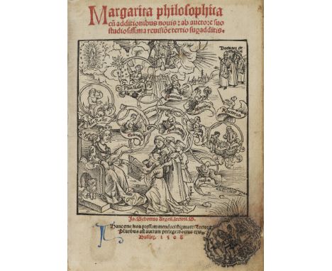
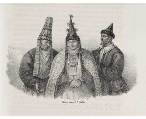
Inkunabeln - Postinkunabeln - - Gregor Reisch. Margarita philosophica cu(m) additionibus novis: ab auctore suo studiosissima revisio(n)e tertio sup(er)additis.) Durchgehend rot und blau rubriziert. Mit Titelholzschnitt, 17 ganzs. Holzschnitten, zahlr. Textholzschnitten sowie zwei gefalteten Holzschnitt-Tafeln. Basel, M. Furter & J. Schott, 14. März 1508. 316 Bll. 8°. Blindgeprägtes Ldr. d. Zt. über Holzdeckeln mit späterem hs. RSchild (Gelenke geplatzt, Bezug u. Rücken mit Fehlstellen, teils wurmstichig, Schließen fehlend). Erste Basler Ausgabe, insg. 3. Ausgabe (EA 1503). - VD16 R 1036. - Sabin 69129. - Graesse VI, 73. - ADB 28, 117. - Vgl. Smith, Rara 83. - Nicht im BM STC und bei Adams. - Die Margarita Philosophica gilt als eine der frühesten und bedeutendsten Enzyklopädien Europas. Sie ist in Dialogform zwischen Lehrer und Schüler abgefasst und behandelt die Freien Künste, sowie die Naturwissenschaften, darunter, Astronomie, Musik (mit Holzschnitt-Noten) Medizin, Geometrie, Mechanik und Physik etc. Die schönen und detailgetreuen Holzschnitte zeigen allegorische Darstellungen von Philosophie, Mathematik, Musik, Baukunst, Medizin, Religion u.v.a. - "Die Gliederung in zwölf Bücher, die in das Trivium der rationalen Philosophie (Buch I: Grammatik, II: Logik, III: Rhetorik), dann in das Quadrivium der reale Philosophie (IV: Arithmetik, V: Musik, VI: Geometrie, VII: Astronomie, VIII: Physik Naturphilos., IX: Naturkunde, X: Physiol., XI: Psychol.) und schließlich als Gipfel des Studiums in die Moralphilosophie (XII) einführen, spiegelt im wesentlichen das aristotelisch-scholastische Wissenschaftssystem in der Umbruchphase zwischen Spätscholastik und Humanismus wider." (ADB) - Ohne die Weltkarte. Nicht identifizierter Sammlerstempel auf Titel (Initialen "RS" in figürl. Darstellung). Erste Bll. mit kl. Einriss im linken weißen Rand. Fliegende Vorsätze fehlend. Etwas gebräunt, vereinzelt leicht fleckig. Zwei Holzschn. mit übermalten Genitalien. Einige wenige Bll. im äußersten weißen Rand minimal wurmspurig. Einige sehr wenige zeitgen. Marginalien. Insgesamt gutes Exemplar des bedeutenden und seltenen Werks. Incunabula - Postincunabula - With title woodcut, 17 fullpage woodcuts, numerous woodcuts in text and two folded woodcut plates. Blind-tooled cont. leather over wooden boards with later handwr. spine label (joints cracked, cover and spine with missing parts, some wormholes, clasps missing). - First Basel edition, 3rd edition in total (first ed. 1503). - The Margarita Philosophica is considered one of the earliest and most important encyclopaedias in Europe. It is written in dialogue form between teacher and pupil and deals with the liberal arts, as well as natural sciences, including astronomy, music (with woodcut notes), medicine, geometry, mechanics and physics etc. - Without the world map. Unidentified collector's stamp on title (initials "RS" in figurative representation). First few pages with small tear in left white margin. Flyleaves missing. Somewhat browned, sporadically lightly spotted. Two woodcuts with overpainted genitalia. A few leaves minimally worm-marked in the outermost white margin. A few very isolated cont. marginalia. Overall a good copy of this important and rare work.

Lot 426

Rhein - - Der Lauf des Rheins von Basel bis Rotterdam. Cours du Rhin de Basle à Rotterdam. Lithographierte u. teilkolorierte Karte in drei Teilen, 136 x 18,5 cm. Wesel, J. Bagel, um 1900. Zeigt den Rheinlauf von Waldshut bis zur Mündung. - Links und rechts mit 15 Ansichten von Städten sowie Sehenswürdigkeiten entlang des Rheins. - Papierbedingt zart gebräunt, im Blattrand mit kl. Einrissen und wenigen Läsuren, leicht fleckig, mit etw. größerem Feuchtigkeitsfleck. Insgesamt in guter Erhaltung. Lithographed a. partly coloured map in three parts, around 1900. - Shows the course of the Rhine from Waldshut to the mouth. - On the left and right side with 15 views of towns and sights along the Rhine. - Due to paper slightly browned, the margins with small tears and a bit stained, with slightly larger moisture stain. Overall in good condition.

Lot 379

Russland - - K. C. T. Friedmann Goebel. Reise in die Steppen des südlichen Russlands... in Begleitung der Herren C. Claus und A. Bergmann. 2 Bde. in 1 Bd. Mit lithographischem Widmungsblatt, 18 lith. Tafeln u. 1 gefalt. lith. grenzkol. Karte. Dorpat, A. Kluge, 1838. XIV S., 1 Bl., 325 S., 1 Bl., VIII, 372 S. 4°. HLdr. d. Zt. mit Marmordeckeln, Lederecken u. dreiseitig gefärbtem Schnitt (beschabt, berieben u. bestoßen). Henze II, 360f. - Pritzel 3432. - Erste Ausgabe. - Seltene Reisebeschreibung des bedeutenden Pharmazeuten F. Goebel, welcher die Reise im Auftrag des Zaren unternommen hatte. "Sein Hauptanliegen war die chemische Untersuchung der Salzseen, der Salzkräuter, die chemische Analyse des Wassers des Kaspischen, des Asowschen und des Schwarzen Meeres sowie die Untersuchung der Exhalationen der tamanischen Schlammvulkane. Daneben wurden barometrische und hodometrische Messungen ausgeführt, Pflanzen und Tiersammlungen angelegt. Die Reise brachte der Wissenschaft mehrfachen Gewinn, nicht zuletzt auch der Erdkunde." (Henze) - Der botanische Abschnitt wurde von Claus unter Hinzuziehung der Botaniker Ledebour, Bunge und Mayer bearbeitet. Neben den Pflanzenzeichnungen fertigte er auch die Zeichnungen für den ersten Teil mit Ansichten von Bergen, Seen, Einheimischen, u.a. - Innengelenke angebrochen, tls. etw. stockfleckig (wenige Bll. etw. stärker betroffen), papierbedingt teils zart gebräunt. Insgesamt überwiegend sehr sauberes und wohlerhaltenes Exemplar mit differenzierten Tafeln. Russia - 2 parts in 1 vol. With lithographic dedication sheet, 18 lith. plates and 1 fold. lith. border col. map. Cont. half leather binding with marbled covers, leather corners and three sided coloured edges (somewhat scuffed, rubbed and bumped). - First edition. - Rare travel description by the important pharmacist F. Goebel, who went on the journey on behalf of the Tsar. - The botanical section was edited by Claus with the assistance of the botanists Ledebour, Bunge and Mayer. In addition to the plant drawings, he was also responsible for the drawings for the first part with views of mountains, lakes, local people, etc. - Inner joints crakced, partly somewhat foxed (a few leaves slightly more affected), a bit browned due to the paper. Altogether a mostly very clean and well-preserved copy with differentiated plates.

Lot 411

Berlin - Brandenburg - - Daniel Friedrich Sotzmann. Generalcharte von der Altemarck. Berlin, Kunz, 1788. Teilkolorierter Kupferstich auf Bütten. 47 x 50 cm (50 x 57 cm). Mit großer, figürlicher Titelkartusche, Legende und nicht identifiziertem Wasserzeichen. - Siedlungstopographischen Karte und frühe Arbeit des Geographen der Berliner Akademie Sotzmann. Mit Einzeichnung der Wind- und Wassermühlen, Ziegeleien, Poststraßen, Wäldern, Mooren, Wiesen und Wüstungen. - Mit geglättetem Mittelfalz. Unscheinbar fleckig, meist nur im weißen Rand. Insgesamt sehr sauber und mit schönem Kolorit. Partly coloured copper engraving on laid paper. - With large figural title cartouche, legend and unidentified watermark. - Settlement topographic map and early work by the geographer of the Berlin Academy Sotzmann. With inscriptions of wind- and watermills, brickworks, post roads, forests, moors, meadows and deserts. - With smoothed centrefold. Insignificantly spotted, mostly only in the white margins. Overall very clean and with nice colouring and wide margins.

Lot 287

China - - Neue vollständige Karte von China. Tokio, Taisho 3 (1914). Format ca. 124,5 x 148,5 cm. Mehrfach gefaltet. In HLwd.-Mappe mit chines. DTitel (berieben, bestoßen, etw. fleckig). Großformatige chromolithographische Karte von China mit chines. Titel, Legende u. mont. Korrekturzettel. - Papierbedingt gebräunt, kl. Randläsuren, Falze tls. hinterlegt u. mit Einrissen, tls. wasserrandig u. mit Abklatsch. New complete map of China. Folded several times. In half cloth folder with printed Chinese title (rubbed, bumped, somewhat stained). - Large format chromolithographic map of China with Chinese title, legend and mounted correction sheet. - Browned due to paper, small marginal defects, folds partially backed and with tears, partly waterstained and with offset.

Lot 834

2. Weltkrieg - - Großformatige Fluchtkarte von West-Europa auf Seide. Sheet C u. Sheet D. Wohl Großbritannien, um 1942. Farbdruck auf Seide, beidseitig gestaltet. Maße aufgefaltet: 73 x 73 cm. Die Briten gaben diese Art von Karten aus, um Soldaten bei der Flucht zu helfen, wenn diese hinter feindlichen Linien gefangen waren. Seidenkarten wurden verwendet, weil sie haltbar, leicht zu verstecken und zu transportieren waren und keine Geräusche verursachten. - Blatt C umfasst Holland, Belgien (außer Westküste), Frankreich (Nordost), Deutschland (West und Mitte). Die Legende zeigt wichtige Durchgangsstraßen, andere Hauptstraßen, Nebenstraßen, besondere Autobahnen, Eisenbahnen, Kanäle, internationale Grenzen und ehemalige Grenzen. Die Rückseite, Blatt D, ist in 2 Karten unterteilt und umfasst die Erweiterung der neuen deutsch-belgischen Grenze sowie Frankreich (Südosten), Deutschland (Südwesten), Schweiz (außer Südosten). - Mehrfach gefaltet. Vereinzelt minimale Anschmutzungen. Insgesamt in wirklich sehr gutem Zustand, Farben sehr gut erhalten. World War 2 - Large format escape map of Western Europe on silk. Sheet C and Sheet D. Printed on both sides. Probably Great Britain, around 1942. Colour print on silk.- The British issued this type of map to help soldiers escape when they were trapped behind enemy lines. Silk cards were used because they were durable, easy to hide and carry, and made no noise. - Sheet C covers Holland, Belgium (except west coast), France (north-east), Germany (west and centre). The legend shows important transit roads, other main roads, secondary roads, special highways, railways, canals, international borders and former borders. The reverse side, sheet D, is divided into 2 maps and includes the extension of the new German-Belgian border as well as France (south-east), Germany (south-west), Switzerland (except south-east). - Folded several times. Isolated minimal soiling. Overall in very good condition, colours very well preserved.

Lot 795

A Embroidery plus a Map a Staffordshire.

Lot 324

Property of a Gentleman. Charles Booth (1840 - 1916), A 'Poverty Map' of Battersea, 1902. Chromolithograph on paper. Originally published by Charles Booth in 1902 as part of his monumental study, 'Life and Labour of the People in London', this map clearly shows, on a scale of six inches to the mile, the socials status of each street at the time. Street names are clearly legible and each is coloured, ranging from black (denoting the 'lowest, vicious, semi-criminal class'), through gradations of blue, purple, pink, red, and yellow (denoting the 'wealthy, servant keeping' classes). Dimensions: (Paper) 13.75 in. (H) x 14.75 in. (W) (Frame) 18.75 in. (H) x 20 in. (W)

Lot 5042

Amended Description The Legend of Zelda A Link to the Past - Super Nintendo - SNES This lot contains a boxed and complete (with manuals) copy of A Link to the Past for the SNES. It also contains the map and Top Secrets booklet.Condition Report: The box is in very good condition with only one side ever being opened (the black Nintendo seal is still on the other side). All the inserts are in great condition. These inserts do include the Top Secrets booklet, which still has its Triforce seal intact.

Lot 217

Esnauts (Jacques) and Michel Rapilly. Nouveau Plan Routier de la Ville et Faubourgs de Paris Avec ses Principaux Edifices Par M. Pichon, large wall map of Paris, the border decorated with 28 vignettes of architectural and historical sites of interest, including a view of Palace of Versailles, with allegoriacal title cartouche in the upper left adorned with a nymph of the Seine, engraved map by Michel Glot, with some early hand-colouring, on four sheets joined, total 1050 x 1510 mm (41 1/4 x 59 1/2 in), under glass, a few printer's creases and some handling creases, a few small nicks and small losses, surface dirt and toning, framed, M. Pichon, Paris, 1790⁂ Vignettes include: place de Louis le Grand; nouvelle église de la Madeleine; Hotel de Ville; la Sorbonne; Galerie du Louvre du côté de la rivière; La place Royale; Eglise Cathédrale de Notre-Dame; le Palais du Luxembourg.

Lot 214

Bryant (Andrew) Map of the County of Norfolk from Actual Survey by A.Bryant in the Years 1824, 1825 and 1826, Respectfully dedicated to the Nobility, Clergy & Gentry of the County, large scale county map in two sections, calligraphic cartouche, list of the ecclesiastical divisions, compass rose, table of explanation and fine engraved vignette of Norwich Cathedral in the lower right corner, engraving with bright original hand-colouring, each sheet approx. 710 x 2250 mm (28 x 79 3/4 in), dissected and mounted on linen, edged with green-coloured linen, some surface dirt and spotting, folding with green endpapers, scuffed, contemporary book-style slipcase, gilt, worn, 4to, 1826.

Lot 184

Central Asia.- Abbott (Capt. James) Narrative of a Journey from Heraut to Khiva, Moscow, and St. Petersburg, during the late Russian invasion of Khiva, 2 vol., first edition, portrait lithograph, folding engraved map, bound without half-titles, bookplate, contemporary calf, rebacked retaining original backstrip, a little rubbed, 8vo, 1843.⁂ Provenance: Bookplate of Frederick Abbott (1805-92), brother of the author.

Lot 242

Hong Kong.- Volonteri (Simeone) Carte Topographique de l'ile de Hong Kong dressée par Mgr. S. Volonteri de la Congregation des Missions Etrangères de Milan Vic. Apoost du Ho-non (Chine) ancien Missionaire de Hong-Kong, detailed bilingual map of Hong Kong and its environs, with locations in Chinese and French, lithographs, on thin wove paper without watermark, map 250 x 300 mm (9 7/8 x 11 3/4 in), sheet 310 x 475 mm (12 1/4 x 18 3/4 in), very minor offsetting, two vertical folds, probably as issued, unframed, printed by Stab. Fratelli Tensi, Milan, 1874 ⁂ Scarce; we can trace no other copies sold at auction. Monsignor Simeone Volonteri (1831-1904) was an Italian missionary, who spent a decade in Hong Kong, and in 1860 joined the Mission of the Propaganda in the Roman Catholic Diocese of Hong Kong. Prior to producing the present map Volonteri made one other of Hong Kong in 1866, 'Map of the San-On District, (Kwangtung Province)'.

Lot 240

Geology.- Knipe (James Alexander) A Geological Map of England & Wales, and Part of Scotland, showing also the Inland Navigation..., detailed geological map of England and Wales, a slightly later state with Knipe's name removed, engraving with full original hand-colouring, 1435 x 995 mm (56 1/2 x 39 2/4 in), dissected and mounted on linen, minor surface dirt and spotting, folding with green cloth-covered ends into book-style slipcase, red morocco gilt label to spine, slightly scuffed and worn, upper cover join slightly loose and lifting off, a few ink spots, 8vo, J. & C. Walker, [c. 1837]

Loading...Loading...
  • 109182 item(s)
    /page

Recently Viewed Lots