

Burnaby (Fred) . A Ride to Khiva: Travels and Adventures in Central Asia, 1878, New York, 2 colour folding maps to front & rear pockets, maps slightly toned & worn with minor wear & tear, period inscription to front endpaper, some minor toning throughout, cracked guttering, original gilt decorated green cloth, lightly rubbed to head & foot, 8vo, together with Forsyth (J.) , The Highlands of Central India..., new edition, 1889, colour plates, black & white folding map and illustrations, later inscription to front half-title with attempted removal with correction fluid, minor toning, original gilt decorated green cloth, spine lightly rubbed to head & foot, 8vo, and Cook (H.C.B.) , The Battle Honours of the British and Indian Armies 1662-1982, limited edition 270/750, 1987, limitation page signed by the author, original cloth in dust jacket & slipcase, 8vo, plus other 19th century & modern travel & military reference and related, including The Oregon Trail, by Francis Parkman, 5th edition, 1874, mostly original cloth, some gilt decorated, some in dust jackets, G/VG, 8vo/4to (Qty: 3 shelves)
We found 109182 price guide item(s) matching your search
There are 109182 lots that match your search criteria. Subscribe now to get instant access to the full price guide service.
Click here to subscribe- List
- Grid
-
109182 item(s)/page
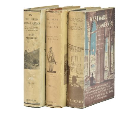
Shah (Sirdar Ikbal Ali). Westward to Mecca. A Journey of Adventure through Afghanistan, Bolshevik Asia, Persia, Iraq & Hijaz to the Cradle of Islam, 1st edition, H. F. & G. Witherby, 1928, 12 photogravure plates including frontispiece, publisher's ticket to front pastedown, original green cloth, dust jacket (slightly frayed at extremities), 8vo , together with: Dyer (Reginald Edward Harry). The Raiders of the Sarhad. Being the Account of a Campaign of Arms and Bluff against the Brigands of the Persian-Baluchi Border during the Great War, 1st edition, H. F. & G. Witherby & Co., 1921, 15 photographic plates including frontispiece, 2 sketch-maps, almost entirely unopened, publisher's ticket to front pastedown, original orange cloth, dust jacket (slightly frayed at extremities), 8vo, and Whistler (Hugh), In the Himalayas. Sport and Travel in the Rhotang and Baralacha, with some Notes on the Natural History of that Area, 1st edition, H. F. & G. Witherby, 1924, 16 photographic plates including frontispiece, sketch map, publisher's ticket to front pastedown, original green cloth, dust jacket (a few nicks, spine soiled and repaired), 8voShah: Macro, Arabian Peninsula 1272. Whistler: Czech (Asia) p. 225; Yakushi W129. The publisher's file copies, all extremely rare in the dust jacket.(Qty: 3)

Smith (Robert Angus). To Iceland in a Yacht, 1st edition, Edinburgh: privately printed by Edmonston & Douglas, 1873, 6 autotype photographic plates, 7 other plates (2 folding), original green pictorial cloth gilt, spine slightly rolled and with small white mark, 8vo, together with: Dasent (George Webbe), The Story of Burnt Njal, or Life in Iceland at the End of the Tenth Century. From the Icelandic of the Njals Saga, 2 volumes, 1st edition, Edinburgh: Edmonston and Douglas, 1861, folding engraved map frontispiece, 2 folding lithographic maps, 4 engraved plates, 2 plans, original green pictorial cloth gilt, 8vo, Coles (John), Summer Travelling in Iceland; being the Narrative of Two Journeys across the Island by Unfrequented Routes, 1st edition, John Murray, 1882, 10 wood-engraved or lithographic plates including frontispiece, folding map (spotted), original blue cloth,wear to spine-ends, large 8vo, Laurie (William Ferguson Beatson), A Tour to Northern Europe, (Denmark, Sweden, Russia), 1st edition, Saunders, Otley, and Co., 1862, 5 steel-engraved plates including frontispiece, contemporary gift inscriptions to front pastedown, all edges gilt, original green cloth gilt, 8vo, McCormick (William T.), A Ride Across Iceland in the Summer of 1891, 1st edition, Digby, Long & Co., 1892, photographic frontispiece, marginal finger-soiling to preliminaries, ownership inscription effaced from title-page verso, stitching strained between quires D and E, original green cloth gilt, small 8vo, and 12 others, 19th-century Scandinavian travel, original cloth, 8voCopac traces eight copies of Smith's work in UK libraries, seven for Laurie, and seven for McCormick; of these last two copies are also noted in red cloth. Dasent's work was also issued in a far less elaborate binding with blind rather than gilt decoration to the sides.(Qty: 20)
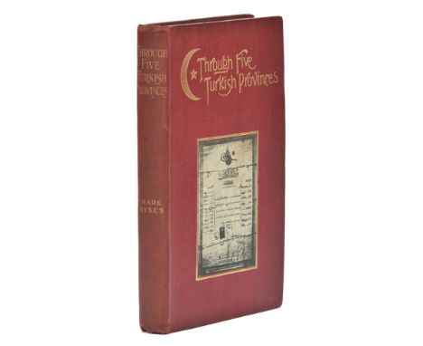
Sykes (Mark). Through Five Turkish Provinces, 1st edition, Bickers and Son, 1900, photogravure frontispiece, 20 halftone plates, folding map, spotting to frontispiece, title-page and folding map, top edge gilt, others untrimmed, original red cloth, gilt titles, pictorial onlays to boards, spine rolled, 8voFirst edition of the first book by the traveller and politician now notorious as the architect of the Sykes-Picot agreement, which describes the author's journey from Damascus to Batumi (modern-day Georgia) via Aleppo, Baghdad, Mosul, Lake Van and Tbilisi. Scarce: Copac locates seven copies in UK libraries; a handful traced at auction. For the author's second book see the following lot.(Qty: 1)
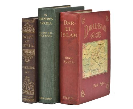
Sykes (Mark). Dar-ul-Islam, a Record of a Journey through Ten of the Asiatic Provinces of Turkey, 1st edition, Bickers & Son, 1904, 76 plates including frontispiece and 3 unlisted plates at pp. 38, 40 and 80, 21 maps (of 22: lacking 'Essengeli to Shaykhli' map as usual), many folding, spotting to endpapers and preliminaries, short closed tear to General Map, ownership inscription 'J. S. Chubb, Sledmere' (Sledmere in Yorkshire was Sykes's ancestral home) to front pastedown, top edge gilt, others untrimmed, original red cloth, pictorial onlay to front board, spine rolled and marked, headcap refurbished, corners bumped, tide-mark to upper outer corner of front board, 8vo, together with: Cheesman (Robert Ernest), In Unknown Arabia, 1st edition, Macmillan and Co., Limited, 1926, 32 photographic plates including frontispiece, folding colour map (closed tear to stub), spotting to half-title and edges, original green cloth, gilt vignette to front board, pale mottling to extremities, 8vo, and St John (James Augustus), Egypt and Nubia, their Scenery and their People, being Incidents of History and Travel, from the Best and most Recent Authorities, including J. L. Burckhardt and Lord Lindsay, Chapman and Hall, [circa 1800], wood-engravings in text, gilt edges, original cloth, 8voFirst edition of Sykes's second book (for his first see the previous lot), and a bright copy of Cheesman's work (see Macro 711).(Qty: 3)

Teichman (Eric). Travels of a Consular Officer in North-West China, 1st edition, Cambridge, University Press, 1921, photographic frontispiece, 29 similar plates numbered 1-58, 4 maps of which 2 folding in end-pocket (one with marginal tape-repair), a few spots to preliminaries, original red cloth, 8vo, together with: Pratt (Antwerp Edgar), To the Snows of Tibet through China, 1st edition, Longmans, Green, and Co., 1892, 30 halftone or wood-engraved plates, folding map, a few leaves clumsily opened, ink-stamps to edges of text-block, original blue pictorial cloth gilt (refurbished), 8vo, and 11 other Chinese travel accounts, late 19th- and early 20th-century, including Bland and Backhouse's China under the Empress Dowager (1st edition, 1910) and E. G. Kemp's The Face of China (1st edition, 1909), all in original cloth, 8voCordier Sinica 3340 (Teichmann), 2150 (Pratt).(Qty: 13)
Thomson (Charles Wyville & Murray, John). Report on the Scientific Results of the Voyage of the H.M.S. Challenger during the years 1873-76, under the command of Captain George S. Nares and Captain Frank Tourle Thomson, 44 bound volumes (of 50), 1st edition, London, Edinburgh, etc.: HMSO for Longman & Co. [and others], 1880-95, approximately 3,000 plates, charts and maps, mostly lithographed, many tinted and many hand-coloured, some double-page and folding, largely unopened, some inner hinges cracked, bookplate of the Library of the Faculty of Physicians and Surgeons, Glasgow to pastedowns, original publisher’s green cloth gilt, a little rubbed, 4toNissen BBI 2381; Nissen ZBI 4554; Spence 1198; Wood, p. 596. A largely complete and handsome set of the official accounts of the most important nineteenth-century circumnavigation of the globe. It was bound up in a complex way, the complete set originally comprising 50 bound volumes with many volumes bound in more than one part. The six volumes missing here are all from Zoology section which was originally published as 32 volumes bound in 40. This set lacks the Zoology volumes 5, 6, 12, 14, 16 & 18 (Text, Part II), each bound as one volume.The missing Zoology reports therefore are Parts 14-17 (Ophiuroitea; Actiniaria; Anatomy of the Thylacine, Cucus and Phasgogale; Tunicata), 34 (Annelida Polychaeta), 38 (Tunicata. Second part), 39 (Holothurioidea. Second part), 40 (Radiolaria, concluding part) and 44-47 (Nemertea; Cumacea; Phyllocarida; Pteropoda. First part - Gymnosomata). HMS Challenger embarked from Portsmouth on 21 December 1872 under the direction of the Scottish professor Charles Wyville Thomson and his Canadian-born assistant and naturalist John Murray. This was the first time that physicists, chemists and biologists collaborated with expert navigators to map the sea. During the four-year voyage they circumnavigated the globe, travelling 69,0000 nautical miles across the Atlantic, Pacific and Antarctic oceans. They sounded the ocean bottom to a depth of 26,850 feet, discovered 715 new genera and 4,717 new species of ocean life forms, including many deep-sea specimens. Among their discoveries were many of the fish and marine creatures thought at that time to be of legend. Numerous specimens from the voyage are on view in one of the largest collections in the Natural History Museum. The fifty-volume, 29,500-page, report took twenty-three years to compile and publish.(Qty: 44)
Thomson (Sir C. Wyville). The Voyage of the 'Challenger'. The Atlantic, a Preliminary Account of the General Results of the Exploring Voyage of H.M.S. 'Challenger' during the year 1873 and the early part of the year 1876, 2 volumes, 1st edition, Macmillan & Co., 1877, engraved portrait frontispiece to first volume (with gift inscription note tipped onto verso), folding colour lithograph map frontispiece to second volume, forty-two plates, maps, etc., including some folding, ink ownership name stamp to titles, some very light spotting mostly to preliminaries and some light marginal toning, original blind decorated green cloth, gilt decorated spines, few spots to upper board, generally in bright condition, 8voSpence 1197. Thomson was scientific director on board HMS Challenger during its three-year circumnavigation of the globe under George Nares.(Qty: 2)
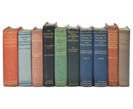
Tucker (Alfred R.) Eighteen Years in Uganda and East Africa, 2 volumes, 1st edition, Edward Arnold, 1908, photogravure portrait frontispiece to volume 1, colour frontispiece to volume 2, 59 plates, folding map, volume 1 frontispiece loosening at head, spotting to endpapers, preliminaries and edges (occasionally encroaching on margins), original blue cloth gilt, 8vo, together with: Woon (Harry Vernon), Twenty-Five Years' Soldiering in South Africa. A Personal Narrative, 1st edition, Andrew Melrose, 1909, engraved portrait frontispiece (toned, marginal spotting and damp-staining, 18 plates, folding map (short closed marginal tear), top edge gilt, original dark green cloth gilt, a few marks, headcap nicked, 8vo, Lloyd (Albert Bushnell), In Dwarf Land and Cannibal Country. A Record of Travel and Discovery in Central Africa, 1st edition, T. Fisher Unwin, 1899, photogravure portrait frontispiece, numerous full-page photographic illustrations in text, 3 maps (2 folding), top edge gilt, others untrimmed, original red pictorial cloth gilt, 8vo, and 6 others, African travel, original cloth, 8voCzech (Africa) p. 169 (Lloyd); Mendelssohn II p. 637 (Woon).(Qty: 10)

Villari (Luigi). Fire and Sword in the Caucasus, 1st edition, T. Fisher Unwin, 1906, halftone frontispiece, numerous similar plates, text-block spotted, top edge gilt, others untrimmed, original red pictorial cloth, spine slightly faded, 8vo, together with: Stewart (Robert Walter), The Tent and the Khan: a Journey to Sinai and Palestine, 1st edition, Edinburgh: William Oliphant and Sons, 1857, photogravure frontispiece (slightly spotted), wood-engraved vignettes in text, folding map to rear, original red cloth, pictorial decoration gilt to spine, slightly rubbed overall, light wear to extremities, spine-ends strengthened, 8vo, Williams (George), The Holy City. Historical, Topographical, and Antiquarian Notices of Jerusalem, 2 volumes, 2nd edition ('with additions'), John W. Parker, 1849, 15 tinted lithographic plates including frontispieces (of 16: lacking plate facing volume 1 p. 446) and a folding panorama (loose), 7 engraved plates (one folding), woodcut vignettes, folding map on glazed linen in pocket at front of volume 1, plates spotted, inner hinges strengthened, original cloth, rubbed, wear and restoration to extremities, 8vo, and 6 others, early 20th-century Middle Eastern travel, original cloth, 8voVillari's work concerns the Armenian-Tatar massacres which began during the 1905 Russian Revolution. Stewart's work is usually encountered in various colours of blind-stamped binding without the gilt illustration to the spine seen here.(Qty: 10)

Wellby (Montagu Sinclair). 'Twixt Sirdar and Menelik. An Account of a Year's Expedition from Zeila to Cairo through Unknown Abyssinia, 1st edition, New York: Harper & Brothers, 1901, halftone frontispiece, portrait plate, numerous photographic text illustrations (many full-page), original brown pictorial cloth gilt, 8vo, together with: Burdo (Adolphe), The Niger and the Benueh. Travels in Central Africa, 1st edition in English, Richard Bentley & Son, 1880, 12 wood-engraved plates including frontispiece (2 folding), all edges gilt, original red pictorial cloth gilt, slightly marked, spine rolled, tips bumped, 8vo, Arnot (Frederick Stanley), Garenganze; or Seven Years' Pioneer Mission Work in Central Africa, 1st edition, James E. Hawkins, 1889, frontispiece, folding map, endpapers spotted, original green pictorial cloth gilt over bevelled boards, 8vo, ibid., Bihé and Garenganze; or, Four Years' Further Work and Travel in Central Africa, 1st edition, J. E. Hawkins & Co., Ltd., 1889, frontispiece, 2 folding maps, original cloth-backed pictorial boards, spotted and toned, extremities rubbed, 8vo, and 1 other, African travelCzech (Africa) p. 297 for Wellby's work.(Qty: 4)

Camden (William). [Britannia siue Florentissimorum regnorum, Angliae, Scotiae, Hiberniae, et insularum adiacentium ex intima antiquitate chorographica descriptio...., Nunc postremò recognita, & magna accessione post Germanicam aeditionem adaucta, London: George Bishop, 1600,] lacking letterpress title and preliminaries but retaining the decorative title with an oval map of the British isles displayed in an allegorical border by William Rogers, tipped in portrait of William Camden, seven plates of coins and one (only of two) folding engraved map of England and Wales, map trimmed with slight loss to strapwork margin along upper border, later endpapers, modern calf with contrasting morocco gilt label to spine, thick 8vo, together with Philipot (John), Remaines concerning Britain: Thomas Warren for Isabella Waterson, 1657, title page with near contemporary manuscript ownership signature, decorative woodcut initials with later hand colouring, slight spotting and offsetting, later endpapers, modern calf gilt with contrasting morocco label to spine, 8vo (Qty: 2)
Coxe (William). An Historical Tour in Monmouthshire; illustrated with views by Sir R. C. Hoare Bart. A new map of the county and other engravings..., 2 parts bound in one, printed for T. Cadell & W. Davies, 1801, printed title, dedication and preface, engraved folding map by Natl. Coltman with short handling tear, 91 engraved views and plans (including two folding), some staining throughout, contemporary marbled calf gilt, re-backed but retaining original spine, some wear to extremities, 4to (Qty: 1)
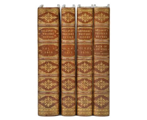
Dallaway (James & Cartwright, Edmund). A History of the Western Division of the County of Sussex, 2 volumes in three, 1st edition, 1815-1830, titles in red & black, 5 foldng or double-page engraved maps (including double-page hand-coloured loosely inserted map, plus two other hand-coloured map, one in outline), 74 engraved plates and plans (including 2 double-page plates, 4 hand-coloured plates, and 5 plans, comprising 3 folding, 1 double-page, 3 hand-coloured), numerous pedigrees (3 folding), illustrations to text and numerous armorials, offsetting and spotting, together with The Parochial Topography of the Rape of Arundel, in the Western Division of the County of Sussex, by James Dallaway, a New Edition by Edmund Cartwright, volume 2, part 1 only, 1832, title in red & black, double-page engraved map, 21 plates and plans (including one hand-coloured plate, two folding & one double-page plan, spotting and offsetting, all edges gilt, armorial bookplates of Christopher Turnor, Stoke Rochford Library and John Roland Abbey to front endpapers of each volume, uniform contemporary Russia calf by Clarke & Bedford, elaborate gilt decorated spines, light wear to joints, large 4toAn attractive set. The preface to the volumes suggest only 110 copies of volume 1, 250 copies of volume 2, part 2, and 200 copies of the new edition of volume 2, part 1 were printed. Formerly the property of book collector Major J. R. Abbey (1894–1969), whose library was largely sold at Sotheby's from 1966-1970. Provenance: From the Library of Colin & Joan Deacon.(Qty: 4)NB: Revised Estimate : now £600-800
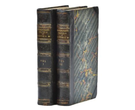
Buckingham (James Silk). Travels in Assyria, Media, and Persia, 2 volumes, 2nd edition, Henry Colburn and Richard Bentley, 1830, engraved folding map frontispiece, 26 wood-engraved plates, folding map partially split along one fold, short closed tear in volume 1 signature Z4, contemporary half calf, recased, restoration to corners, 8vo (21.1 x 13.2 cm)Macro 608; not in Atabey or Blackmer. First octavo edition; the work was first published in quarto format the previous year, and was Buckingham's fourth and final book describing his Middle Eastern travels. It notably includes, according to the full title, a 'description of Bussorah, Bushire, Bahrein, Ormuz, and Muscat' and a 'narrative of an expedition against the pirates of the Persian Gulf'. There are also descriptions of the 'Joasmee' (the Qawasim, the modern-day rulers of Sharjah), 'Bethoobee' (Abu Dhabi), and 'Graine' (Kuwait).(Qty: 2)

Hissey (James John). A Drive through England or a Thousand Miles of Road Travel, 1st edition, 1885; On the Box Seat, from London to Land's End, 1st edition, 1886; A Holiday on the Road, An Artist's Wanderings in Kent, Sussex, and Surrey, 1st edition, 1887; A Tour in a Phaeton through the Eastern Counties, 1st edition, 1889; Across England in a Dog Cart from London to St. Davids and Back, 1st edition, 1891, and On Southern English Roads, 1st edition, 1896, together 6 volumes, wood engraved plates and few folding maps, bookplate of Henry W. Ryland to upper pastedowns, uniform near contemporary dark green half calf by Mudie, elaborate gilt decorated spines with morocco labels, 8vo, together with The Road and the Inn, 1917, black & white plates and folding map, edges untrimmed, modern half calf gilt, 8vo, plus three others by James Hissey including Through Ten English Counties, 1894; Over Fen and Wold, 1898 and Untravelled England, 1906, all in original cloth, 8voProvenance: From the Library of Colin & Joan Deacon.(Qty: 10)

Laurie (Robert & Whittle James). Third edition corrected to 1809 of Laurie and Whittle's New Traveller's Companion; exhibiting a complete and correct survey of all the direct and principal cross roads in England, Wales and Scotland as far north as Edinburgh and Glasgow to which have been added the roads to Perth & Aberdeen, Greenock, Irvine, Ayr, Port Patrick, Wigton &c. - by Nathl. Coltman. Prefixed also is a new general map which exhibits the whole at one view, published Laurie & Whittle Feb. 12th 1806 [but 1809 edition], double page calligraphic title, advertisement, index and table of explanation, folding engraved map of England & Wales and twenty-five (complete) double page engraved route maps, all with contemporary outline colouring, slight staining and finger soiling, later endpapers, near contemporary half morocco gilt over printed boards, rubbed and worn, large 8voThis third edition of 1809 not listed in Chubb.(Qty: 1)
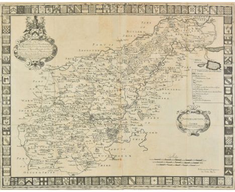
Morton (John). The Natural History of Northampton-shire with some account of the antiquities to which is annex'd..., printed for R. Knaplock and R. Wilkin, 1712, printed title with small ink ownership stamp, , dedication and preface, uncoloured engraved folding map by John Harris and fourteen (complete) uncoloured engraved plates, index bound at rear, mid 20th century ownership signature to front endpaper, book plate of Cecil John Grimes D. D., contemporary panelled calf , re-backed, folio (Qty: 1)

Moule (Thomas). England's Topographer or the English Counties delineated, published George Virtue, 1838, portrait frontispiece of Queen Victoria, decorative title, four-sheet map of England & Wales, a comparison plate of the 'Principal Hills of Great Britain' and 55 decorative engraved county maps and town plans by Thomas Moule, including folding engraved plan of London, folding engraved map of the Metropolitan Boroughs and an oval decorative map of London, the map of the Metropolitan Boroughs with some closed tears repaired on verso, all maps re-guarded at gutter, some maps trimmed with slight loss to printed image, some spotting, later endpapers, modern half calf gilt on marbled boards with contrasting label to spine, 4to (Qty: 1)

Nash (Treadway Russell). Collections for the History of Worcestershire, 2 volumes, 2nd edition, 1799, engraved portrait frontispiece, folding engraved map to volume 1 (strengthened to folds at verso and reguarded), engraved vignette title to each volume, 73 engraved plates & plans (including two engraved dedication leaves, lacking three plates & one with repaired closed tear), numerous engraved illustrations to text and 18 folding pedigrees, 13 engraved leaves of Domesday Book, includes Supplement at rear of volume 2, one or two paper repairs, ink stamps to lower outer corners of titles and manuscript number to verso, contemporary half calf gilt, rebacked preserving original contrasting morocco labels, corners repaired, folioUpcott page 1330.(Qty: 2)
Spencer (Nathaniel). The Complete English Traveller; or, a New Survey and Description of England and Wales, London: J. Cooke, 1772, engraved frontispiece and 57 plates (one folding), 3 engraved maps including folding map of Great Britain (single-page map of England and folding map linen-backed, and map of England also cropped at fore-edge), index incomplete at rear, small torn hole to page 1 (B1) not affecting text, occasional dampstains and few marks etc., hinges repaired, contemporary calf, rebacked and board edges repaired, folioProvenance: From the Library of Colin & Joan Deacon.(Qty: 1)


1920 framed and glazed map of Lake Hanchow, China with dedication (a/f). Dedication reads "A Chinese map of the Lake of Hanchow purchased there in 1920 by Captain W.H.Coombs (officially named Ku Oum Soo - 'smiling forest' whilst serving as Assistant Cartographer to The Chinese Maritime Customs Service [The Hai Kwang}). Frame size approx. 87cm x 102cm.


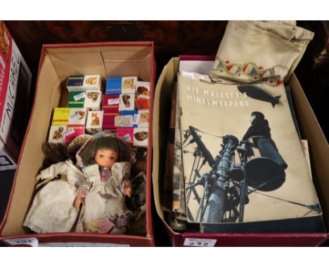
Collection of Wade Whimsies miniature animals (some in original boxes), small porcelain headed doll and another doll. Together with a box of wartime pamphlets, various, including 'His Majesties Minesweepers' 'The Battle of Britain', 'The Eight Army', 'Bomber Command', 'The Campaign in Burma' etc and a First World War period printed map of Europe on linen. (2)(B.P. 24% incl. VAT)


After W G Baxter, two coloured prints for Pears, A Quiet Game at Nap, Nap for All I'm Worth and Spoofed by Jove, 28 x 35cm; after H Alken, Tutor's Assistant, two coloured prints, 21.5 x 26cm, a framed map, Environs of Plymouth and Devonport, an unframed circular wall mirror and a coloured print after Van Goethem, (7).


Emanuel Bowen (fl.1714 - died 1767) - Coloured engraving - "An Accurate Map Of The County Of Kent Divided Into Its Lathes..." - With inset views of Canterbury and Rochester Cathedrals, the border picked out in yellow watercolour, 16ins x 19.5ins, printed for Carington Bowles, No. 69, St. Paul's Churchyard, 1777 (unframed)


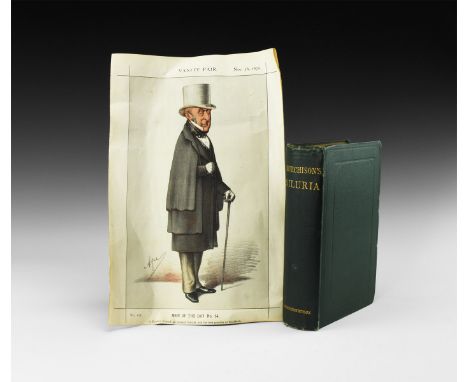
Published 1872 and 1870 AD. Murchison, Sir Roderick I(mpey), Siluria: A History of the Oldest Rocks in the British Isles and Other Countries, London, 5th edition, illustrated (coloured frontispiece, map and 200 images); in original cloth binding; accompanied by a coloured print portrait 'Men of the Day No 14' of Murchison from Vanity Fair for 26 November 1870, with the linked text page. 1.10 kg total, book 23 x 16cm, portrait 36 x 24cm (8 3/4 x 6 1/2, 14 x 9 1/2"). Ex libris Stuart Baldwin, Essex, UK. A standard text, including fossils from these ancient rocks. [2, No Reserve] Good condition; slight wear to spine.
-
109182 item(s)/page