We found 109182 price guide item(s) matching your search
There are 109182 lots that match your search criteria. Subscribe now to get instant access to the full price guide service.
Click here to subscribe- List
- Grid
-
109182 item(s)/page


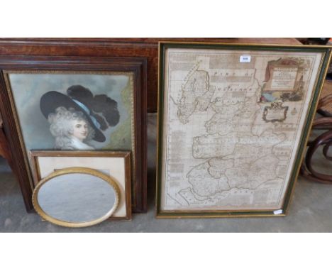
Lot 231
William Howitt - 'Ruined Abbeys and Castles of Great Britain and Ireland' pub. 1864;'Lithographic Views in Manchester'; P Villars 'England Scotland and Ireland' pub 1887 in vellum boards, John Ogilby strip map and 2 others (6) Condition Report & Further Details Click here for further images, condition, auction times & delivery costs


Lot 422
Topographical volumes including An Inventory of the Historical Monuments of Hertfordshire, R L Hine The Natural History of the Hitchin Region, Hitchin Worthies, W Cudworth Manningham, Heaton & Allerton Townships of Bradford 1896 and H Chauncey The Historical Antiquities of Hertfordshire Volume 1 1825 (with folding map)


Lot 403
A collection of assorted militaria and related collectables, to include; assorted ' V For Victory ' enamel cufflinks, a Fire Guards Handbook, a Small Arms Training pamphlet, RAC Telephone Box keys (with original envelopes), a vintage London Underground Map and other related sundries. Interesting collection.

Lot 463
A rare WWII Second World War Nazi German Third Reich publicaction ' Militargeographische Angaben uber England: Bildheft England insegesamt (3 Auflage) ' published by the German General Staff, Berlin September 1940. In green card covers size. 177 pages. A visual guide to England from the air, with 174 black and white photographs which appear to focus on aerial views of harbours, ports, coastal features, industry, rivers and country landmarks. Excludes London. Headed 'Not For Public Distribution' Along with Great Britain Road Map published by the German General Staff, Berlin July 1940. On paper which has been folded, size 100 by 68 cm. Scale 1:1,000,000. Key gives details of various road surfaces and grades, plus population of towns down to those under 5,000 inhabitants. Includes the instruction that this is not for public distribution.

Lot 375
A rare 19th century Anglo-Zulu war framed and glazed battle plan map for the ' Plan Of The Battle For Isandhlwana 22nd January 1879, Showing Also Rorke's Drift And The Proposed New Camp And The Surrounding Country ' Prepared from original sources and Capt CL Morris Newman's Plan by John Sanderson. The map being hand coloured in places with notation to lower left corner reading ' Extra To The Natal Colonist, February 1979. Frame measures: 46cm x 3cm.

Lot 458
A rare original WWI First World War soldier's Trench map. Herzeele and Winnezeele, edition 1a France and Belgium Sheet Local 27 NE (western half), published by Field Survey Company RE , code 9201, dated 22.8.18. Trenches corrected from information received up to 20.6.18 according to information in the top l/h corner. Scale 1:20,000. On folding linen. Size 58 by 46.5 cm. Owner’s name and rank to reverse. The owner served in the Durham Light Infantry and the Northumberland Fusiliers and was wounded in France. Along with: The Western Front: Drawings by Muirhead Bone, published by authority of the British War Office by Country Life, London 1916-17. 1st edition. In stiff cloth-covered boards size 31 by 32 cm. 206 pages. With an introduction by Sir Douglas Haig. Over 100 black & white and sepia engravings and 70 colour plates. Bone was one of the senior official war artists and he seems to have been given a wide range of subjects to portray, from life in and behind the trenches to the Home Fleet; the shipyards of the Clyde and aircraft factories in Britain. The book appears to have published as a way of bringing together a series of separate monthly art works by Bone that Country Life produced from December 1916 through to October 1917.
Lot 315
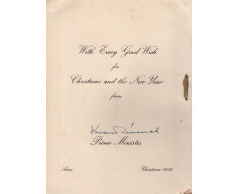
NKRUMAH KWAME: (1909-1972) Ghanaian Revolutionary, the first Prime Minister (1957-60) and President (1960-66) of Ghana, having led the Gold Coast to independence from Great Britain in 1957. Vintage signed official Christmas greetings card, the cream small 4to stiff folding card featuring a colour illustration of a map of the Gold Coast to the inside. Signed ('Kwame Nkrumah') in fountain pen ink with his name alone to the inside, in his capacity as Prime Minister, beneath a printed greeting, Accra, 1956. Tied with a small gold ribbon and with the gold embossed emblem of the Gold Coast to the front cover. Some light foxing and a few slight creases to the outer covers, G
![[§] BOYLE FAMILY (SCOTTISH CONTEMPORARY) UNTITLED Inscribed verso 'To Avril and Richard, with love from the Boyle Family',](https://cdn.globalauctionplatform.com/1fbc2d95-bf62-4fb7-9201-aa4900a08149/67e2c2c7-3a95-46e2-a021-aa8e01136fb1/468x382.jpg)
Lot 210
[§] BOYLE FAMILY (SCOTTISH CONTEMPORARY) UNTITLED Inscribed verso 'To Avril and Richard, with love from the Boyle Family', mixed media, resin and fibreglass 40.5cm x 40.5cm x 6cm (16in x 16in x 2.25in) Provenance: The Boyle Family gifted this work directly to the present owner Note: This work is believed to be a maquette for a larger work, a private commission for a British collector c. 2000. Note: Their collective comprises husband, wife, son and daughter, but beyond being close family members, the Boyle Family are artistic collaborators. This began soon after Mark Boyle, a Glaswegian by birth, and Joan Hills, originally from Edinburgh, met whilst living in Yorkshire in the 1950s. Their children Sebastian and Georgia were exposed to studio life from an early age, ultimately opting to continue the collaboration into adulthood. Though initially exhibiting under Mark's name alone, they represented themselves as 'Boyle family' as soon as the artworld expanded its narrow mindset to perceive the nature of their collaborative process, as opposed to only understanding it through the typical mythologizing of the (usually) male artist as loner/genius. From the very first, the work itself had been the primary focus and importance, and they did not divert themselves with attempts to challenge art world stereotypes or with efforts to market themselves in a calculated manner. Now, happily, the industry recognises, respects and celebrates the unique approach to their collective practise. Their work was experimental and cross disciplinary from the start, with famous early projects including innovative visual installations in collaboration with musicians like Jimi Hendrix and the Soft Machine. Elements of film and performance continue to play a part in their practise, but it is the Earth Series for which they are best known. The Earth Series, in their own words, 'are three dimensional casts of the surface of the earth which record and document random sites with great accuracy. These works combine real material from the site (stones, dust, twigs etc) with paint and resins, preserving the form of the ground to make unique one-off pieces that suggest and offer new interpretations of the environment.' The full details of their materials, casting technique and how they achieve such accurate representations is a well-kept family secret. Randomness, chance and an attempt to eliminate all bias are underpinning concepts of this project. Sites were selected on the map by the throw of a dart whilst blindfolded, and the precise patch of ground to be immortalised narrowed down by the toss of a t-square over the shoulder. No subject is above or beneath capture and depiction. Their aim is to create a truthful and unadorned representation of a fleeting moment of reality, freeing us, the audience, from our typical interpretation of art via projected prejudices, cultural reference points, associations and reminiscences. Though Mark Boyle sadly passed away in 2005, the family continue their work. Boyle Family has exhibited in galleries and museums world-wide, including representing Britain at the Venice Biennale in 1978 and the Sao Paulo Biennale in 1987. Their exhibition 'Beyond Image' at London's Hayward Gallery in 1986 attracted 176,000 visitors. Their work is represented in many private and public collections with major works in forty museum collections worldwide, including Tate Britain; Stuttgart Staatsgalerie; Los Angeles County Museum; Kunstmuseum Luzern; Tokyo Metropolitan Museum; Museum Moderna Kunst Vienna. The National Gallery of Scotland, Edinburgh, hosted a major retrospective of the family's work in 2003.


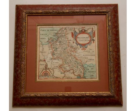
Lot 3295
17th-century map of Buckinghamshire, Saxton & Hole, hand-coloured copper engraving on laid paper, together with an engraved architectural view of Chantmarle House, two Thomas Moule maps of Boston and Cambridgeshire, and a sheet of armorial/heraldic crests from an 18th-century Owen & Bowen road map for Oxford to Cambridge, all framed (5)

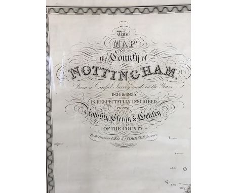
Lot 3237
Collection of three antique maps of Nottingham: A New Map of Nottinghamshire, published by Henry Overton, 1714, with inset town plan of Nottingham, hand-coloured engraving on laid/chain-lined paper, 36cm by 51cm; An Accurate Map of Nottinghamshire, by Emanuel Bowen, published by Carington Bowles, 1 June 1777, laid paper, 51cm by 43cm; Map of the County of Nottingham, by C. & J. Greenwood, published 26 January 1831, 59cm by 69.5cm. All unframed, mounted in printseller's protective wrappers (3)


Lot 3235
Collection of antique Staffordshire maps, 18th & 19th century, to include a large county map by C. & J. Greenwood, 1830, with inset etching of Lichfield cathedral; a large county map by Emanuel Bowen, published by J. Bowles, no date; engraved topographical view of Croxton Abbey after Samuel & Nathaniel Buck, dated 1731; and a quantity of smaller engravings and lithographs, most of which are mounted in printseller's wrappers, all housed in a protective wallet


Lot 176
Folio Society . The Source of the Nile, the Lake regions of Central Africa, by Richard F. Burton, 1994, with black & white facsimile map, Captain Cook's Voyages 1768-1779, 1997, William Russell Special correspondent of The Times, 1995, Crusader Castles, by T.E. Lawrence, 2010, The Campaigns of Napoleon, 3 volumes, by David G. Chandler, 2002, together with 61 further volumes of history Folio Society publications, all original cloth in slipcases, G/VG, 8vo (Qty: 67)

Lot 184
Meinertzhagen (Richard). Birds of Arabia, 1st edition, 1954, folding map contained in rear pocket, numerous colour and monochrome illustrations, original cloth, spine faded, small stains to upper cover, price-clipped dust jacket, spine a little faded with small chips at ends, 4to, together with The Typographic Book 1450-1935, by Stanley Morison & Kenneth Day, 1963, numerous illustrations, original cloth, price-clipped dust jacket, a few chips, 4to, plus Izaak Walton. The Complete Angler, the Lives of Donne, Wotton Hooker Herbert & Sanderson, Nonesuch Press, 1929, illustrations, a few leaves unopened, top edge gilt, original russet morocco, spine and joints toned, slipcase, 8vo, limited edition 1033/1100, plus others including Tombleson's Views of the Rhine, edited by W.G. Fearnside, [1832] and An Old Shropshire Oak, by the late John Wood Warter, edited by Richard Garnett, 4 volumes, 1886-91 (Qty: 42)
Lot 186
Monsarrat (Nicholas), The Cruel Sea, 1st edition, Cassell & Company, 1951, additional half title, slight scattered spotting, publisher's cloth gilt, dust jacket with slight wear, 8vo, together with, The Ship that Died of Shame & other stories, 1st edition, 1959, additional half title, publisher's cloth gilt, dust jacket, 4to, with The Nylon Pirates, 1st edition, 1960, publisher's cloth gilt, dust jacket, 8vo, plus The Tribe That Lost Its Head, 1st edition, 1956, additional half title, frontispiece of a map of Pharamaul, Bombay Book Depot stamp to title, publisher's cloth gilt, dust jacket, 8vo, and The Story of Esther Costello, 1st edition, 1953, additional half title, contemporary presentation inscription to front endpaper, publisher's cloth gilt, dust jacket with some creasing and slight wear, 8vo, with another eighteen volumes by the same author mostly first editions and all but one with dust jackets, including two American first editions (This is the Schoolroom & Castle Garac), all 8vo (Qty: 23)

Lot 2
Europe. Dufour (A. H.), Carte Itineraire de L'Europe indiquant les limites actuelles des Etats..., Paris, 1843, large folding engraved map with contemporary outline colouring, sectionalised and laid on linen, calligraphic cartouche and table of explanation, 920 x 1235 mm, with a marbled card chemise and slipcase, chemise with old sellotape repairs, short split to slipcase (Qty: 1)
Lot 205
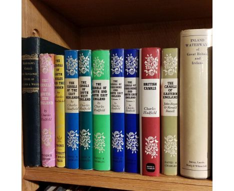
De Salis (Henry Rodolph) . Bradshaw's Canals and Navigable Rivers of England and Wales, A Handbook of Inland Navigation..., 1918, folding map to rear pocket, some light toning, original gilt decorated green cloth, boards & spine lightly rubbed to head & foot, 8vo, together with Hadfield (Charles) , The Canals of Southern England, 1st edition, 1955, The Canals of South Wales and The Border, reprint edition, 1960, ...of The East Midlands, 1st edition, 1966, ...of South West England, 1st edition, 1967, ...of South and South East England, 1st edition, 1969, ...of Yorkshire and North East England, 2 volumes, 1972-73, numerous black & white illustrations, all original cloth in dust jackets, some covers slightly rubbed to head & foot with minor loss, 8vo, and Edwards (Lewis A.) , Inland Waterways of Great Britain and Ireland, 1st edition, 1962, black & white illustrations, some minor spotting, original cloth in dust jacket, spine lightly faded, 8vo, plus other modern canal & inland waterway reference & related, mostly original cloth in dust jackets, G/VG, 8vo (Qty: 3 shelves)
Lot 213
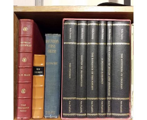
Ellis (M.H.) . Francis Greenaway, his life and times, limited edition 7/350, 1949, The Shepard Press, Australia, signed by the author to the limitation page, colour portrait frontispiece, colour and black & white illustrations, publishers original gilt decorated red full morocco, spine lightly rubbed, 4to, together with Charles Knight [publisher] , The Library of Entertaining Knowledge, New Zealanders, 1830, black & white map frontispiece plus illustrations, new endpapers, some light marks & toning, modern calf spine retaining contemporary half calf boards, boards rubbed with some loss, 8vo, and Ransome (Arthur) , "Racundra's" First Cruise, 1st edition, 1923, period inscription to the front endpaper & title page, black & white illustrations, some light toning & spotting, original blue cloth, boards & spine slightly rubbed, 8vo, plus other modern Antipodean reference & miscellaneous literature & history, mostly original cloth in dust jackets, some paperbacks, G/VG, 8vo/4to (Qty: 6 shelves)
Lot 230
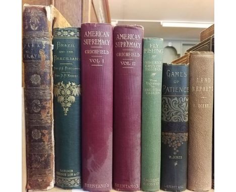
Park (Mungo) . Travels in the Interior Districts of Africa:..., 1799, printed by W. Bulmer, black & white portrait frontispiece plus 2 folding maps & 2 folding plates, book plates to front endpapers, endpapers to frontispiece detached, title page torn to spine, some light marks & off setting, contemporary full calf, front board detached, boards & spines rubbed with loss, 4to, together with Fletcher (J.C. & Kidder, D.P.) , Brazil and The Brazilians..., new edition, 1866, black & white folding map to the front plus numerous illustrations, split gutters, minor toning, original gilt decorated green cloth, spine lightly rubbed, 8vo, and Crichfield (George W.) , American Supremacy..., 2 volumes, 1908, New York, top edge gilt, uniform red cloth, spines slightly rubbed to head & foot, 8vo, plus other 19th century & modern travel, fishing & miscellaneous reference, mostly original cloth, some in dust jackets, G/VG, 8vo/4to (Qty: 3 shelves)
Lot 233
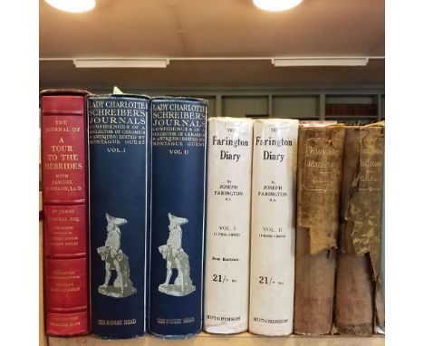
Boswell (James) . The Journal Of A Tour To The Hebrides with Samuel Johnson, LL.D., limited edition 1179/2000, 1974 , map endpapers, publishers original red quarter morocco in slipcase, 8vo, together with Guest (Montague J. [editor]) , Lady Charlotte Schreiber's Journals..., 2 volumes, 1911, black & white plates, top edge gilt, light spotting throughout, uniform original blue cloth, spines slightly rubbed to head & foot, 8vo, and Farington (Joseph) , The Farington Diary, 2 volumes, 3rd edition, 1923, black & white illustrations, uniform original cloth in dust jackets, covers marked & rubbed to head & foot with loss, 8vo, plus other biography & history reference, mostly original cloth, many in dust jackets, some paperbacks, G/VG, 8vo/4to (Qty: 3 shelves)

Lot 3
Gloucestershire. Speed (John), Glocestershire contrived into thirty thre severall hundreds & those againe into foure principall devisions. The citie of Glocester & Bristowe discribed with the armes of such noble men as have bene dignified with ye titlles of Earles & Dukes thereof, published Thomas Bassett & Richard Chiswell, [1676], uncoloured engraved map, inset town plans of Gloucester and Bristol, some marginal fraying with very slight loss, some creasing, lightly toned overall, central fold partially strengthened on verso, 385 x 515 mm, English text on verso, together with a collection of approximately 200 topographical views, portraits, maps, antiquities and news paper cuttings, all relating to Gloucestershire, mostly small format, various sizes and condition (Qty: approx. 200)

Lot 5
Hamburg. Visscher (Nicolas), Nobilissimi Albis Fluvii ostia nec non Hamburgense..., circa 1668, engraved linear map in two parts, with contemporary hand colouring, oriented to the south, showing the course of the lower Elbe, from Nidermarschacht to the river's mouth, inset view of Hamburg, slight overall toning, some creasing but confined to margins, 395 x 540 mm, framed and glazed, together with, Seutter (Matthaus). Hamburgen celeberrima libera Imperii et hanseatica civitas ac Opulentissimum Emporium, circa Ostium Albis ad Mare Septentr. Augsburg, circa 1740, engraved map with contemporary hand colouring, plan of Hamburg with a key identifying fifty-three locations, with panoramic prospect (flanked by allegorical vignettes) below map, title repeated in German, watercolour heavily oxidised, 505 x 590 mm, framed but lacking glass, with a small etched plan of Florence, late 18th century, trimmed and laid on later paper, 125 x 135 mm, framed and glazed (Qty: 3)
Lot 50
Anderson (Johann). Histoire naturelle de l'Islande, du Groenland, du détroit de Davis et d'autre pays situés sous le nord, traduite de l'allemand par M**, 2 volumes, 1st edition in French, Paris: Sébastien Jorry, 1750, engraved frontispiece, folding map, 6 folding engraved plates (of 7), toning, a few spots, contemporary French mottled calf, gilt spines, a little worn, small 8vo (16.2 x 9.3 cm), together with: Taylor (Isaac), Scenes in Africa, for the Amusement and Instruction of Little Tarry-at-Home Travellers, 1st edition, Harrison and Son, 1820, engraved hand-coloured folding map as frontispiece, 26 engraved folding plates with 84 numbered images, later hand-colour, final 2 plates loose, original boards, rebacked, marked and worn, small 8vo (16.4 x 9.4 cm), and 5 others, early-19th-century juvenile travel accounts in English, and similar, small 8vo (Qty: 8)Anderson's work was first published in German in 1746, and contains much information on whaling.
Lot 51
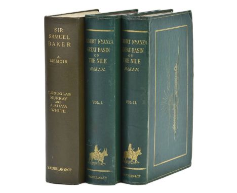
Baker (Samuel White). The Albert N'yanza, Great Basin of the Nile, and Explorations of the Nile Sources, 2 volumes, 1st edition, Macmillan and Co., 1866, engraved portrait frontispiece to volume 1, tinted lithographic frontispiece to volume 2, large folding map (with 10 cm closed tear), one further map, 11 wood-engraved plates, contemporary ownership inscriptions to initial blanks, original green pictorial cloth gilt, volume 1 rebacked with original spine laid down, pale mottling to rear board, volume 2 with scattered pale mottling, head of spine refurbished 8vo, together with: Murray (T. Douglas, & A. Silva White), Sir Samuel Baker, a Memoir, 1st edition, Macmillan and Company, 1895, photogravure portrait frontispiece, 5 plates, 4 folding maps, bookplate of Bridlington Friends' Library, endpapers browned, edges untrimmed, original dark green cloth, 8vo (Qty: 3)Czech (Africa) p. 15 for the first item.
Lot 57
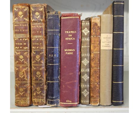
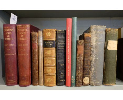
Hedin (Sven). Central Asia and Tibet, Towards the Holy City of Lassa, 2 volumes, 1st edition, 1903, portrait frontispiece to each, numerous black & white plates and illustrations, folding maps (folding map at rear of volume 1 torn and repaired), ink stamp to titles, endpapers renewed, top edge gilt, original cloth gilt, rebacked preserving original spines, upper covers marked where label removed, large 8vo, together with Todd (Henry John). Some Account of the Deans of Canterbury; from the new foundation of that church, by Henry the Eighth, to the Present Time. To which is added a Catalogue of the Manuscripts in the Church Library, Canterbury & London, 1793, upper blank margin of title torn and repaired, contemporary calf, rebacked preserving original spine, morocco title label, 8vo, with Oliver (George) , Historic Collections, relating to the Monastries in Devon, Exeter: Printed by R. Cullum, 1820 , occasional spotting, original boards with later cloth spine and printed paper title label, 8vo, and Salter (Thomas Frederick). The Anglers Guide; being a New, Plain, and Complete, Practical Treatise of the Art of Angling for Sea, River, and Pond Fish..., 6th edition, carefully corrected & enlarged, 1825, engraved portrait frontispiece, wood engraved vignette to title (few letters skinned with loss), wood engraved plates and illustrations, frontispiece & title reattached, some spotting and finger-soiling, wax seal stamp to verso of final leaf, contemporary half calf, lacking spine label, rubbed and some wear, 12mo in 6s, plus Kennedy (John) , A Treatise upon Planting, Gardening, and the Management of the Hot-House, volume 1 only (of two), 2nd edition, corrected & greatly enlarged, 1777 , title underlined in ink, contemporary half calf, paper label at foot of spine, lacking upper board detached (replacement full calf board provided), lower joint cracked, worn, 8vo, plus The Parks and Gardens of Paris, by William Robinson, 1878, original cloth, spine and lower board damp soiled, 8vo, together with other British topography related including, Paterson's Roads, by Edward Mogg, 16th edition, 1822, title detached and torn, folding engraved maps, original diced calf, 8vo, The Walloons and their Church at Norwich by William Moens, Lymington, 1888, ex-library copy with usual ink stamps, modern red library buckram, 4to, plus three others (Qty: 12)
Lot 58
Heylyn (Peter). Cosmographie, 1673, engraved title-page dated 1669 (chipped, trimmed and mounted), 1 engraved folding map only (of 4: only Asia present and laid down), 20th-century calf-backed marbled boards, folio, together with: Lane-Poole (Stanley). Social Life in Egypt, [c.1880], engraved vignette title-page, 5 engraved plates including frontispiece, contemporary marbled sheep, joints cracked, 4to, Sacheverell (Henry), The Tryal of Dr. Henry Sacheverell, before the House of Peers, for High Crimes and Misdemeanors, printed for Jacob Tonson, 1710, initial licence leaf, contemporary panelled calf, leather lifting from boards, wear to extremities, folio, and [ Paris], Views of Paris, Rock & Co., [c.1880], title-page, 120 steel-engraved vignettes on 60 plates, original black roan, rubbed, 8vo (Qty: 4)Sold not subject to return.

Lot 6
London . Reynolds (James), Reynolds' Map of London with Recent Improvements. Divided into Quarter Mile Sections for Measuring Distances, circa 1880, engraved map with contemporary outline colouring, sectionalised and laid on linen, 600 x 850 mm, bound in contemporary cloth gilt boards, spine faded, together with Philip (George). Philips' New Map of London extending four miles round Charing Cross, circa 1880, lithographic map with contemporary outline colouring, sectionalised and laid on linen, 770 c 985 mm, bound in contemporary cloth gilt boards, worn and stained (Qty: 2)
Lot 61
Pollen (François P. L., & D. C. van Dam). [Recherches sur la faune de Madagascar, Relation du voyage, part 1 of 5 only, 1st edition, Leiden: J. K. Steenhoff, 1867-8], 44 tinted lithographic plates (of 48) by J. G. Keulemans and others, several hand-coloured as issued, 1 map (of 2), 1 folding manuscript facsimile, lacking title-page and possibly other preliminary text leaves, disbound, housed in a modern button-folder with a photocopy of the title-page mounted to front, folio (Qty: 1)Nissen ZBI 3215.1. Sold as a collection of plates, not subject to return.
![Sailing. There and Back 1934, a Limited Edition for Private Circulation, [c.1934], title-page + 68 pp., linen-backed colour m](https://cdn.globalauctionplatform.com/f6a9df8e-e8f1-4dde-b413-aaa200c78ed8/b0103dab-8eec-4bf7-a2d9-aaa3012fc67b/468x382.jpg)
Lot 62
Sailing. There and Back 1934, a Limited Edition for Private Circulation, [c.1934], title-page + 68 pp., linen-backed colour map, 25 mounted photographs, all edges gilt, original red morocco over bevelled boards, slightly scuffed and rubbed, 4to (27.5 x 19.8 cm) (Qty: 1)Privately printed souvenir journal of a sailing trip on a from Southampton to Cannes via Brest, Lisbon, Gibraltar, Malaga, Alicante, Valencia and Toulon. The passengers are named as Harold Child Beale, Vivian Curtayne Stratton and Reginald Evelyn Child Beale; the latter is named in the Dictionary Of British And Irish Botanists And Horticulturists (p. 57). No copies traced in libraries.

Lot 65
Werner (E. T. C.). Myths & Legends of China, London, Calcutta & Sydney: Harrap, 1st edition, 1922, With Thirty-Two Illustrations in Colours by Chinese Artists, spotting to text, front pastedown with armorial bookplate of Montagu Egerton Weatherall, dated 1923, original pictorial yellow cloth, dust-soiled, spine darkened, 8vo, together with Peplow (S. H. and Barker, M.) , Hongkong, Around and About, 2nd edition, Revised and Enlarged, Honk Kong: Ye Olde Printerie Ltd., 1931, folding map, hand-coloured in outline, title lightly spotted, original cloth-backed boards (some fading to edges), spine with printed paper label (chipped), black lettering to front cover, 8vo, plus Smith (Arthur H.) , Proverbs and Common Sayings from the Chinese..., with Observations on Chinese Things-in-General, New and Revised Edition, Shanghai: American Presbyterian Mission Press, 1914, some spotting, mainly at front and rear, armorial bookplate and ownership inscription of Montagu Egerton Weatherall, dated 1918, original cloth gilt, tiny surface loss to spine, corners bumped, 8vo, with four others China-related, including: China Yesterday and To-Day, by Edward Thomas Williams, 1st edition, New York: Crowell, 1923; Recent Events and Present Policies in China, by J. O. P. Bland and E. Backhouse, 1st edition, Heinemann, 1912 (lacking map) (Qty: 7)The armorial bookplate of Montagu Egerton Weatherall appears in five of the items. Weatherall was a keen semi-professional photographer who spent at least 10 years in Peking, working for the Imperial Chinese Maritime Customs.

Lot 70
Murray's Handbooks. A Handbook to the English Lakes, included in the Counties of Cumberland, Westmoreland and Lancashire, 1st edition, 1889, folding map contained in front and rear pockets, maps and advertisements, original red limp cloth, a few faded patches, 8vo, together with 13 other Murray's Handbooks including Essex, Suffolk, Norfolk and Cambridgeshire, 2nd edition, 1875, Wiltshire, Dorsetshire and Somersetshire, 4th edition, 1882, Hertfordshire, Bedfordshire and Huntingdonshire, 1895, Cornwall, 11th edition, 1893, Ireland, 6th edition, 1902, Buckinghamshire, 1903 and Derbyshire, Nottinghamshire, Leicestershire and Staffordshire, 3rd edition, 1904 (Qty: 14)

Lot 72
Pole (Sir William). Collections Towards a Description of the County of Devon, 1st edition, 1791, half-title with ink ownership signatures, slight spotting, bookplate of Samuel Rigby, hinges cracked, contemporary mottled calf, old reback preserving original spine, front joint partly split, worn, 4to, together with Toulmin (Joshua) , The History of the Town of Taunton, in the County of Somerset, Taunton: printed by T. Norris, 1st edition, 1791, half-title, folding engraved map (repaired to verso), folding engraved plan (with short closed tear), two engraved plates (with pale dampstain to upper outer corners), folding engraved table, list of subscribers, modern brown calf gilt, spine with contrasting labels, 4to (Qty: 2)

Lot 74
Walpoole (George Augustus). The New British Traveller or a Complete Modern Universal Display of Great-Britain and Ireland: [1784], decorative frontispiece with long repaired closed tear, printed title, engraved folding map of England & Wales, twenty-one uncoloured engraved maps and eighty-five engraved topographical views, many with two or more images to one sheet, both maps and views trimmed with some loss to decorative borders, some spotting and staining, bound with an early - mid 19th century run of 'The National Omnibus and General Advertiser, near contemporary half morocco, upper board detached, heavily worn and frayed, folio, together with Nutt (Elizabeth, printer). Magna Britannia et Hibernia..., volume 2 (only), 1720, printed title and nine uncoloured folding maps by Robert Morden (Gloucestershire, Hampshire, Herefordshire, Hertfordshire, Huntingdon, Kent, Lancashire, Leicestershire and Lincolnshire), each with a mileage table, contemporary blind-stamped calf, hinges and joints cracked, upper board near detached, worn and frayed, 8vo (Qty: 2)Sold as a collection of maps, not subject to return.
Lot 9
Touring & Ordnance Survey. A mixed collection of approximately sixty five maps, mostly 20th century, O rdnance Survey, cycling and touring maps, including examples by Bartholomew, Bacon, W. H. Smith, Ordnance Survey and Gall & Inglis, together with twenty-three (complete) touring maps by Bartholomew contained in a leather carrying case, some wear, plus three large scale rolled maps including a map of Great Britain showing accessibility of towns determined by bus routes, a large scale Ordnance Survey map of Eastwood in Nottinghamshire (coloured) and a large scale Ordnance Survey map of Derbyshire, Nottinghamshire and Lincolnshire (waterstained and damaged), with Bartholomew (J. G.). The Royal Atlas of England and Wales, circa 1895, seventy colour lithographic maps, slight staining and spotting throughout, hinges and joints broken with text block detached, contemporary half morocco gilt, heavily worn and stained, folio, plus two copies of Stanford's Library map of London and its Suburbs , and 'Le Monde dans votre main', circa 1935, with a volume on the paintings in the collection of W. M. Mensing, various sizes and condition (Qty: approx. 70)Sold as a collection of maps, not subject to return


Lot 281
Falklands War. Planning ephemera for Operation Corporate 1982, for Vulcan crews UK training for Falklands War bombing missions including in-flight refuelling with Victor tankers, low level coastal penetrations and live 1000lb bombing. Photos including H2S radar, original weapon loading logs (including XM607, attack logs and South Atlantic map - Argentina/Falklands.

-
109182 item(s)/page