We found 109182 price guide item(s) matching your search

Refine your search

Year

Filter by Price Range
  • List
  • Grid
  • 109182 item(s)
    /page

Lot 1128

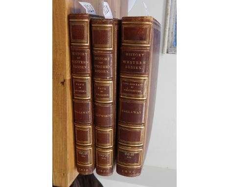
Dallaway, James"A History of the Western Division of the County of Sussex...", 2 vols, vol 1 London T Bensley 1815, vol 2 London Bensley & Son 1819, vol 1 has maps and also a card sheet marked Additament and Cancelled vol 1, plates crossed out and sheets to be crossed out, vol 2 has folding map frontis, plates and ills to both vols, full brown leather, gilt rules, gilt titles, raised bands, marbled bds, bound by Zaehnsdorf Cartwright, Edmund"The Perocial Topography of the Rape of Bramber in the Western Division of the County of Sussex", vol 2 printed by J B Nichols & Son 1830, frontis portrait, folding map, plates, ills, full brown leather, gilt tooled, gilt titles, raised bands, library number to spine, bookplate inside front cover, marbled bds, bound by Zaehnsdorf, t.e.g.

Lot 192

A brass three-draw telescope, fold-out canvas map of Gloucester and other items

Lot 479

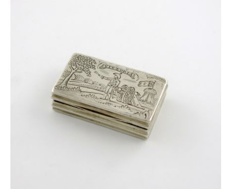
A George III silver engraved snuff box, by Thomas Richards, London 1813, rectangular form, the cover with a depiction of the Duke of Wellington by a canon, holding a map, with a tent behind and a tree to the left, inscribed 'Vittoria', the base with a peacock in a landscape setting, length 4.8cm, approx. weight 0.7oz. On the 21st June ,1813, a British and allied army under Wellington decisively defeated Napoleon near Vittoria in Spain. Provenance: Christie's South Kensington, 20 May 2014, lot 305.

Lot 175

A mid-18th century map, Cambridgeshire, by Eman. Bowen, with hand-coloured detail, 28 x 21in., another, road-map, Buckingham to Bridgnorth, 13.5 x 17in., and a watercolour, young girl carrying basket of oranges, signed S. Hewett, 13.5 x 10in. - all frameless

Lot 262

A 17th century printed map, Buckinghamshire, by Gulielmus Hole, with hand-coloured detail, 11in. square, framed

Lot 243

Quantity of white linen and embroidered tablecloths, handkerchiefs, Victorian scrapbook of verse, cards, photographs, Bacons Excelsior Map of Lancashire, two modern bronze finish mirrors 36cm x 31cm, 4 x 1983 proof decimal coin sets.

Lot 276

A fox mask on wooden shield, Northamptonshire mink hound trophies (2), Northamptonshire Mink Hounds map, a Patey black velvet ridng hat (boxed)

Lot 574

T. Kitchin, hand-coloured county boundary map of Rutland, circ. 1750, a Sansom hand-coloured map of Wales, 1658, and one other, (3).

Lot 606

Limited edition map of Quorn Country, together with various other prints (7)

Lot 428

A selection of vintage road maps, by Bartholomew's s, some early examples , Bacons Cycling Road map of England sheet 6, Edwardian Ordnance Survey Map of the Isle of Wight together with a hand seal, Sheaffer fountain pen, and Conway Stewart pen set .

Lot 394

A group of four Scotland related prints, including a caricature map of Scotland, a drypoint etching of the Brig 'O Dee, and more (4)

Lot 63

A framed Saxons map of Westmorland and Cumbria 1576 WORLDWIDE POSTAGE & PACKING AVAILABLE: Single items £15.99+VAT, multiple items OR large single items £19.99+VAT per parcel. Please contact us for specific quotes. 

Lot 87

A framed and glazed map of Bedfordshire. Measures 26cms high x 20cms wide with the frame and 37cms high x 37cms wide without. WORLDWIDE POSTAGE & PACKING AVAILABLE: Single items £15.99+VAT, multiple items OR large single items £19.99+VAT per parcel. Please contact us for specific quotes. 

Lot 154

A box of book plates; a map of Suffolk etc.

Lot 210

Very Hard to Find MAP (France) Hand Built 1/32 John Deere 5820 Forage Harvester. Extremely Fragile.

Lot 374

Very Hard to Find MAP (France) Hand Built 1/32 John Deere 5460 Forage Harvester with Maize Header. Extremely Fragile.

Lot 375

Very Hard to Find MAP (France) Hand Built 1/32 John Deere 5460 Forage Harvester with with Grass Pickup Header. Extremely Fragile.

Lot 376

Very Hard to Find MAP (France) Hand Built 1/32 John Deere 5730 Forage Harvester with Maize Header. Extremely Fragile.

Lot 1274

A copy of Tom Norton's cycling Map '25 Miles About Llandrindod'.

Lot 1329

A Thomas Kitchin Map of Glamorgan.

Lot 1055

Assorted prints to include; botanical examples, county map of Suffolk etc

Lot 488

A Railway Clearing House official railway map of England and Wales, small edition, together with an official railway map of Scotland (2)

Lot 490

A Railway Clearing House official map of London and Its Environs Condition Report / Extra Information Leather spine in poor condition and largely missing.Tears to cover.Colour good.Date 1913.

Lot 1380

ANTIQUE NEW-FRANCE HAND COLORED MAP, H 27 1/2" IMAGE, W 20 1/2"Framed, measures H.30" x 23" overall.Good condition as viewed thru a clear glass; has horizontal and vertical folds. May have been removed from a book. Njd.- For High Resolution Photos visit Dumouchelles website.

Lot 349

MIXED LOT OF VINTAGE COLLECTABLE'Sincluding a ladies leather travel sewing kit, a Lockwood Brothers of Sheffield horn handled medical bleeding knife with three graduated blades, a map measuring wheel, a cased ivory three section ruler by 'J.Halden, Manchester', a cased six section ivory ruler, a cased metal folding ruler, a Barnet Samuel brass tin whistle and a part rosewood piccolo

Lot 805

A map after Robert De Vaugondy, Gouvernement General D'Orleanois, with hand colouring, and two others, Aethiopia Inferior Vel Exterior and Le Royaume D'Angleterre (3)

Lot 875

A John Ainslie map of Scotland, Drawn and Engraved from a Series of Angles and Astronomical Observations, 1789, mounted on linen and wooden bars for hanging, 163 cm wide Condition report Report by GHGeneral overall browning and discolouration. The back has been reinforced around the panels with black fabric tape. Generally tatty around the edges of the panels that make up the map with folding and small losses throughout. The bottom right corner of the map has started to become detached from the wooden frame at the bottom. Overall generally quite shabby but complete and with no major areas of loss or damage.

Lot 1343

MOTOR RACING T.T Official Guide to 1958, with the official programme and map. Scarce, some slight staining. Good

Lot 1477

EURO 1996 Collection of all 11 programmes from the Euro 1996 tournament in England, plus official supporters guide plus 2 other unofficial guides plus 8 tickets and a Mastercard map and 3 team sheets England v Holland, Switzerland and Scotland. Good

Lot 369

WEST BROM Large West Bromwich Albion presentation pennant. Measures 15" x 12" with tassels and metal handle. Imprinted on the front is "West Bromwich Albion Football Club ", the club crest, a map of the world, players in action and "The Hawthorns founded 1879". Possibly used as a club presentation for European or International friendlies. Horizontal fold. Good

Lot 1084

An Associated Motorway Express Coach Routes map of "The North & Midlands to South Coast", 20 x 19".

Lot 1092

A Western National Omnibus Company Limited "Route Map of Cornwall Area", printed by Wheaton of Exeter, 29 1/4 x 20"

Lot 610

Two Michelin tin map signs.

Lot 907

A Western National Omnibus Company Limited "Route Map of S. Devon & E. Cornwall Area" printed by Wheaton of Exeter, 28 3/4 x 20".

Lot 337

An 18th century map and two watercolour street scenes (3)

Lot 491

A selection of vintage clothing ranging from the 30's to the 60's. Two 1930's nightgowns and two other undergarments. A 1960's fitted lurex dress with black velvet trim to hem and labelled 'Beckol'. Three other pieces. Three interesting scarves, one depicting a map of Burma (11)

Lot 1440

Christopher Saxon Described 17th Century Map of The County of Brecknockshire, Wales. Mounted and Framed Behind Glass. Size 16.5 x 20.5 Inches - Map Only.

Lot 1540

Three boxes of glassware including dessert sets, cut glass vases and glass, etc; together with a map in tube and a box of plated cutlery, jugs, binoculars, etc (four boxes and tube)

Lot 2501

Saxton & Hole: an early 17th Century coloured engraved double sided map 'Vniversi', Derbyshire, circa 1637, 30 cm x 32 cm, framed and glazed together with another Saxton map (2)

Lot 2606

Continental school, Stormy Seascape with mountains beyond, watercolour, signed 'E.A.S. 98', a framed map of Derbyshire, J. ELey (af) together with three other oils (5)

Lot 3134

The Ultra Lens Co, magnifying torch Richard Bock, London, with spare bulb (battery driven) working, cased and a Pathfinder map measurer (2)

Lot 3180

Illustrated London News 1897 map of procession of Diamond Jubilee

Lot 3213

Horse racing interest: a collection of horse racing brouchures to include Frankel and Juddmonte Stallions 2013 and 2014, Kentucky Derby official programme for the 126th Kentucky Derby, Kentucky Horse Park Visitor Guide, 2000 Official Highway Map, commemorative glass tumbler, Kentucky Derby Official Souvenir magazine, 2000 Kentucky Great Gateway Guide, three race tickets, Gainesway 2000 Stud brouchure, various horse racing newspapers, various horse racing books and race venue memorabilia to include Newmarket Race Meetings cards etc

Lot 288

John Speede,hand coloured map engraving, County of Chester, 15" x 20", and map of Hartfordshire, 15" x 20.5", framed, (2).

Lot 313

17/18th century hand coloured map engraving, North Africa, i 13" x 20", and H Moll, map of Buckinghamshire, framed, (2).

Lot 471

An early 19th century hand coloured print depicting the promenade, Blackpool; an 18th century map of Westmoreland; 2 19th century hand coloured prints of waterfalls; Ward, Donkeys on the beach, Blackpool, water colour, framed and glazed

Lot 1200

Postcards, a mixed selection of 6 Bonzo birthday cards for ages 1-6, illustrated by G Studdy, a London Underground Map card and 2 Lowestoft bombardment cards (mainly vg)

Lot 927

Postcards, a collection of 38 NYK shipping line cards, both liners and commercial including artist drawn vignettes, views, other art cards, map card with ports of call etc (mixed condition)

Lot 995

Postcards, box of assorted sleeved postcards, UK topographical, RP's and printed, street scenes, houses, churches, buildings, few foreign and themes, map cards (gd) (approx 450)

Lot 362

TRUDA ELOISE LANE (20TH CENTURY SCHOOL) Three costume designs for 'The Fatal Rubber'; Charles VI of Valois, Isabella of Bavacia and Princess Catherine of Valois, ink, watercolour, body colour and gilt on vellum, each 53.5 x 14cm; and a similar map for 'The Travels of Marco Polo' by the same hand (4)

Lot 67

ROBERT MORDEN A map of Devonshire, hand coloured, 37 x 42 cm; and a C19th map of Dorsetshire. (2)

Lot 68

H. MOLL A map of Buckinghamshire, hand coloured, 30 x 20.5 cm.

Lot 69

L.S. DE LA ROCHETE a map of Greece, Archipelago and part of Anadoli, hand coloured, 54.5 x 78 cm; together with a set of unframed facsimile Ogilby & Morgan's Map of London, in folder, & a folding map of London.

Lot 70

GERARD MERCATOR 'Italia', double page engraved map with decorative title cartouche, ship and sea monster, hand-coloured, 37 x 47 cm.

Lot 72

AN 'IMPROVED MAP OF ENGLAND AND WALES' engraving dated 1798, 58 x 44 cm.

Lot 262

A framed coloured print of Saxton's map of Derbyshire, 1577

Lot 268

Pollyanna Pickering, after, Labrador; another, Grey Mare; John Littler, after, Bakewell Bridge; Ordnance Survey Map on Bakewell (4)

Lot 103

Albert Schweitzer (1875-1965), set of three gold Medals, 1965, by G. Colley for Metalimport Ltd, bust three-quarters right, rev Map of Africa, NOBEL 1952, 22ct, 22, 32, 40mm, total wt 68.88gms, in case of issue, with certificate, numbered 374. Virtually mint state.

Lot 613

LOT OF 67 SINGLE MALT SCOTCH WHISKY MINIATURESTo include Oban 12, Ledaig 1974, Glen Keith 1963, Littlemill 5, Glen Elgin-Glenlivet 14 Cadenhead's and Talisker 10 (map label). All 5cl. 67 bottles. CONDITION REPORT: Some fill levels below shoulder. Viewing recommended.

Loading...Loading...
  • 109182 item(s)
    /page

Recently Viewed Lots