We found 109182 price guide item(s) matching your search
There are 109182 lots that match your search criteria. Subscribe now to get instant access to the full price guide service.
Click here to subscribe- List
- Grid
-
109182 item(s)/page

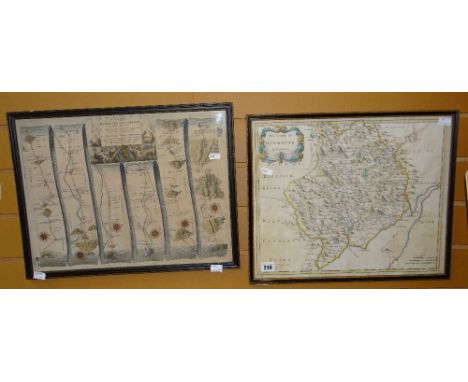
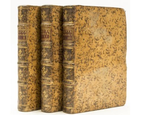
Lot 11
NO RESERVE Castro (Joaõ Bautista de) Mappa de Portugal Angigo, e Moderno, 5 parts in 3 vol., second edition, folding engraved map, woodcut ornaments, licence leaf at end of vol.1, contemporary ink marginalia to a couple of leaves, occasional soiling to upper margin, vol.2 with tear to title and paper flaw holes to upper margin of S4, contemporary mottled sheep, spines gilt with red roan labels, rubbed and a little scuffed, one board worn at edge, Lisbon, Francisco Luiz Ameno, 1762-63 § Eustace (Rev. John Chetwode) A Tour through Italy..., 2 vol., first edition, half-titles, engraved plates, foxed, original boards, uncut, spines a little worn and chipped at head, 1813 § Hooker (W.J.) Journal of a Tour in Iceland..., 2 vol., second edition, hand-coloured engraved frontispiece, engraved maps and plates, some folding, foxing, original boards, uncut, vol.1 lacking spine and upper cover detached (title loose), 1813 § Marshall (Joseph) Travels through Holland, Flanders, Germany..., 3 vol., first edition, half-title in vol.1, browned, contemporary sheep, worn, 1772, rubbed or worn; and 4 others, European travel, 8vo & 4to (14) Saleroom notice: the first mentioned item, Castro’s Mappa de Portugal is lacking 6 maps, there should be 7 in total.⁂ The number of maps in the first appears to vary, many copies do not include any map.
Lot 118
Burton (William) A Commentary on Antoninus his Itinerary, or Journies of the Romane Empire, so far as it concerneth Britain ..., engraved portrait frontispiece and double-page map by Hollar, title printed in red and black, woodcut illustrations, lacks single preliminary leaf 'preface to reader,' occasional manuscript annotations, 2 small rust holes (H1 & 2L1), bookplates, lacking free endpapers, occasional faint spotting, contemporary calf, rebacked, rubbed, [Wing B6185], sm. folio, by Thos. Roycroft [for] Henry Twyford, 1658.
Lot 12
NO RESERVE Cicero (Marcus Tullius) Opera, 10 vol., half-title in vol.1, engraved portrait folding at foot (lightly foxed and offset onto title), contemporary half diced russia, black roan labels, rubbed, Oxford, Clarendon Press, 1783 § Xenophon. Kyros Paideias [graecé]; De Cyri institutione..., edited by Thomas Hutchinson, engraved portrait, folding map, Oxford, Sheldonian Theatre, 1727 § Catullus, Tibullus & Propertius. Opera, inscription at head of title partly erased, Birmingham, J.Baskerville, 1772 § Tacitus (C.Cornelius) Opera quae exstant, 2 vol., additional engraved pictorial title, Amsterdam, D.Elzevier, 1673-72 § Homer. the Iliad and Odyssey..., translated by W.Cowper, 2 vol., 1791 § Spence (Rev. Joseph) Polymetis: or, An Enquiry concerning the Agreement between the Works of the Roman Poets, and the...Ancient Artists, second edition, engraved portrait and plates, some folding, light water-staining, 1755, some foxing or browning, all but the first contemporary calf, rubbed or worn, some covers detached; and c.45 others, classical literature, history etc., v.s. (c.60)
![NO RESERVE [D'Illens (Marc Guérard) & Jakob Funck] Plans und Journals von denan Belagerungen des Letzteren Kriegs in Flan](https://cdn.globalauctionplatform.com/45701490-49ef-492f-a188-aa1801052d9c/1ff73df9-20fc-4556-9325-aa18011603f6/468x382.jpg)
Lot 129
NO RESERVE [D'Illens (Marc Guérard) & Jakob Funck] Plans und Journals von denan Belagerungen des Letzteren Kriegs in Flandern ..., first German edition, folding engraved map and 24 folding battle-plans, one or two partially hand-coloured, woodcut head and tail pieces, this copy without the letter in French at end, contemporary calf, a little rubbed, small loss to spine head, 4to, Strasbourg, Melchoir Pauschinger, 1750.⁂ An account of Louis XV's sieges in the Austrian Netherlands from 1744, when France joined the War of Austrian Succession through an alliance with Prussia, to the conclusion of the conflict in 1748.
Lot 131
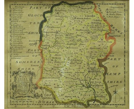
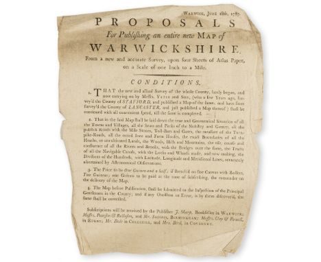
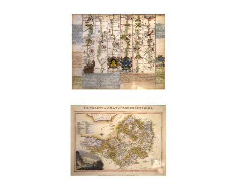
Warwickshire.- Proposals For Publishing an Entire New Map of Warwickshire, From a new and accurate Survey, upon four Sheets of Atlas Paperon a Scale of one Inch to a Mile, printed broadside, folds, browned, slightly soiled at head, edges a little creased and chipped, [unrecorded in ESTC though similar to another prospectus by the publisher], 263 x 215mm., Warwick, J[ohn] Sharp, n.d. [?c. 1785].⁂ A suggested new edition based on Henry Beighton's "A mapp of Warwichshire", first published posthumously in ?1750, this edition may never have been published.
![NO RESERVE Essex.- [Cromwell (Thomas Kitson)] Excursions in the County of Essex, 2 vol., engraved folding map & plan, eng](https://cdn.globalauctionplatform.com/45701490-49ef-492f-a188-aa1801052d9c/09296ee4-04f0-4cb4-9b5d-aa18011608ef/468x382.jpg)
Lot 16
NO RESERVE Essex.- [Cromwell (Thomas Kitson)] Excursions in the County of Essex, 2 vol., engraved folding map & plan, engraved additional pictorial titles and plates, old ink inscription to head of titles, contemporary blue calf, 1818-19 § Braybooke (Richard, Lord) The History of Audley End, engraved plates, contemporary half calf, lacking spine, covers detached, 1836 § Suckling (Rev. Alfred) Memorials of the Antiquities and Architecture...of Essex, engraved or lithographed plates, a few hand-coloured, tinted or chromolithographed, contemporary roan-backed boards, spine defective, 1845 § Buckler (G.) Twenty-Two of the Churches of Essex, plates and plans, contemporary half calf, 1856, foxing and browning, all rubbed or worn; and 8 others on Essex and East Anglia, 8vo & 4to (13)
Lot 23
NO RESERVE India.- Mill (James) The History of British India, 6 vol., folding engraved map, heavy foxing, original boards, uncut, lending library details in manuscript on upper covers, spines worn and defective, 1820 § Thornton (Edward) The History of the British Empire in India, 6 vol., original cloth, one joint split at head, 1841-45 § Law relating to India (The), and the East-India Company, second edition, original cloth, lacking most of label, 1841, foxing, rubbed or worn; and 3 others, similar, 8vo & 4to (16)
![NO RESERVE Isle of Wight.- [Worsley (Richard)] The History of the Isle of Wight, first edition, folding engraved hand-coloure](https://cdn.globalauctionplatform.com/45701490-49ef-492f-a188-aa1801052d9c/718849c3-8d76-4e81-9a89-aa180115def9/468x382.jpg)
Lot 24
NO RESERVE Isle of Wight.- [Worsley (Richard)] The History of the Isle of Wight, first edition, folding engraved hand-coloured map, 31 engraved plates, 12 double-page, engraved vignettes, double-page letterpress pedigree, with Postscript leaf at end, some light offsetting, contemporary half calf, rather worn, joints split, gouge to spine, by A.Hamilton, 1781 § Albin (John) [Map of the Isle of Wight], with inset plan of the town of Newport, engraving with outline hand-colouring, 415 x 620 mm. (16 1/4 x 24 1/4 in), dissected and mounted on linen, folding into contemporary boards with printed label to upper cover, spine split, rubbed, 1832, 4to & 8vo (2)
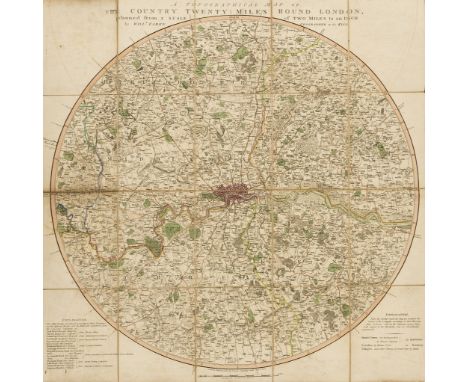
Lot 28
NO RESERVE London.- Faden (William) A Topographical Map of the Country Twenty Miles round London planned from a scale of two miles to an inch, circular engraved map, sheet 625 x 610 mm. (24 1/2 x 24 in), dissected and mounted on linen, minor surface dirt and offsetting, some worm hole damage to beginning of title, folding with printer's label to upper end, contemporary slip-case with printed label to upper cover, worn with some loss, 8vo, 1800; together with a large ordnance survey map of Essex, folding with slip-case, published by Edward Stanford, early 20th century (2).

Lot 29
NO RESERVE London.- Mogg (Edward) An Entire New Plan of the Cities of London & Westminster with the Borough of Southwark, Comprehending the New Buildings and other Alterations, to the Year 1804, Second edition, showing from Hyde Park to Mile End in the east, and Lambeth to Islington, engraved map, with some outline hand-colouring, 460 x 890 mm. (18 1/8 x 35 in), dissected and mounted on linen, browning and surface dirt, some handling creases, folding with slipcase, worn, 8vo [Howgego 227 (2)], 1804.
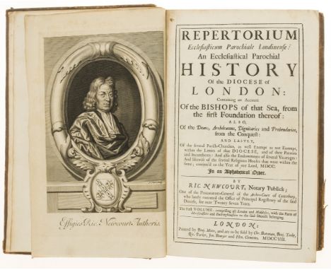
Lot 30
NO RESERVE London.- Newcourt (Richard) Repertorium Ecclesiasticum Parochiale Londinense; An Ecclesiastical Parochial History of the Diocese of London , 2 vol., first edition, vol.1 with engraved portrait, 4 plates (3 double-page) and folding map, errata leaf at end, vol.2 with half-title and list of subscribers, browning to vol.2 particularly at beginning and end, 4N4 defective at foot not affecting text (repaired), last few leaves (Index) shave at fore-edge and wormed at inner margin, contemporary calf, worn, joints split, by Benj. Motte..., 1708-10; and 2 others on London, v.s. (4)⁂ The second volume covers Essex.
![NO RESERVE [Mercier (Louis-Sébastien)] Tableau de Paris, 8 vol. in 4, half-titles, contemporary half calf, Amsterdam, 1782-83](https://cdn.globalauctionplatform.com/45701490-49ef-492f-a188-aa1801052d9c/1c5ae97d-51ee-45d4-89e2-aa18011653b8/468x382.jpg)
Lot 35
NO RESERVE [Mercier (Louis-Sébastien)] Tableau de Paris, 8 vol. in 4, half-titles, contemporary half calf, Amsterdam, 1782-83 § Keate (George) A Short Account of the...Republic of Geneva, folding engraved map, marginal worming at end, contemporary calf, 1761 § Robertson (William) The History of the Reign of the Emperor Charles V, 3 vol., contemporary tree calf, 1769 § Pütter (J.S.) An Historical Development of the Political Constitution of the Germanic Empire, 3 vol., contemporary calf, 1790, some foxing or browning, rubbed or worn, some covers detached; and 17 others on Continental history, 8vo & 4to (28)⁂ The first contains a fascinating picture of Paris and its inhabitants on the eve of the Revolution, further volumes were added later.
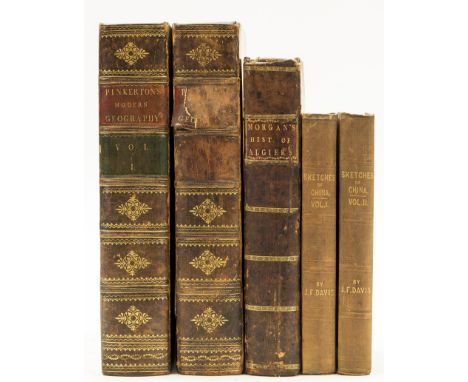
Lot 38
NO RESERVE Morgan (J.) A Complete History of Algiers, browned, some marginal staining, contemporary tree calf, gilt, joints split, by J.Bettenham, for A.Bettesworth & C.Hitch, 1731 § Davis (J.F.) Sketches of China, 2 vol., first edition, half-titles, folding engraved map hand-coloured in outline, advertisement leaf at end of vol.2, some foxing or staining, original pictorial cloth, gilt, rubbed and faded, 1841 § Pinkerton (John) Modern Geography, 2 vol., third edition, engraved maps and plates, some folding, foxing, contemporary mottled calf, spines gilt, vol.2 lacking labels, 1811, rubbed or worn, 4to & 8vo (5)
Lot 42
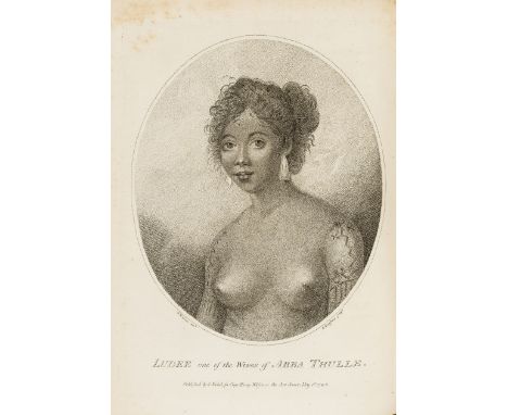
Pacific.- Keate (George) An Account of the Pelew Islands...composed from the Journals and Communications of Captain Henry Wilson... , first edition, stipple-engraved portrait frontispiece, folding engraved map, 15 engraved plates (some stipple-engraved) including folding panorama, tissue guards, errata leaf at end, occasional light foxing or soiling, contemporary mottled calf, rather worn and scuffed, joints split, [Hill 907], 4to, 1788.⁂ "In 1783 the Antelope, commanded by Captain Henry Wilson, was wrecked on a reef near one of the Palau (Pelew) Islands, a previously unexplored group. The entire crew managed to get safely ashore, where they were well treated by the natives and eventually managed to build a small vessel from the wreck, in which they reached Macao. They took Prince Lee Boo, one of King Abba Thulle's sons, with them to England, where he made a very good impression. Unhappily, in spite of all precautions, he soon died of smallpox." Hill
Lot 49
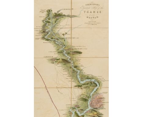
NO RESERVE River Thames.- Tombleson (William) Tombleson's Panoramic Map of the Thames and Medway, vertical strip-map of the Thames from Cirencester to Chatham, showing railway lines, wood-engraved map with original hand-colouring, 1270 x 250 mm., dissected and mounted on linen, some browning and minor offsetting, folding into green cloth boards, printed label to upper cover, worn, J. Reynolds, [circa 1860 or slightly later].
Lot 50
NO RESERVE Scotland.- Campbell (Alexander) A Journey from Edinburgh through Parts of North Britain, 2 vol., hand-tinted aquatint plates, offsetting, contemporary half russia, spines gilt, vol.1 defective at head, 1802 § [Cordiner (Charles)] Remarkable Ruins, and Romantic Prospects of North Britain, 2 vol., engraved frontispiece, vignette titles and plates, contemporary russia, 1788-95 § Buchanan (George) History of Scotland, 2 vol., third edition, engrave portraits, one folding, contemporary calf, 1733 § [Pennant (Thomas)] A Tour in Scotland, 3 vol., fifth edition, engraved vignette titles, map and plates, some folding, one worn and defective at fold, contemporary tree calf, 1790, some soiling and browning, all a little worn, joints split, some covers detached; and another, 4to & 8vo (10)
Lot 1072
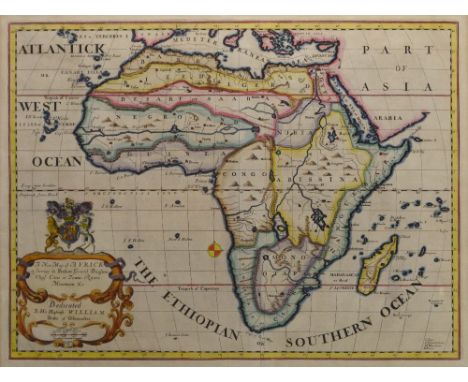
AFTER FREDERICK DE WIT; 'Novissima et Perfectissima Africae Descriptio', a late 17th century copper engraved hand-coloured map of Africa, later issued by R. & J. Ottens, 48.8 x 56.8cm, framed and glazed.Additional InformationWaviness to the paper, central vertical fold/crease, spotting and foxing particularly to corners and edges but present in varying degrees throughout.
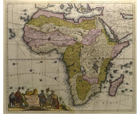
![AFTER JOHANN BAPTIST HOMANN; 'Totius Africae Nova Repraesentatio [...]', an early 18th century hand coloured engraved map of](https://cdn.globalauctionplatform.com/680b153e-6c63-4eed-ba91-aa0f0118148b/b5531200-6fa9-442b-96d3-aa1c011db691/468x382.jpg)
Lot 1073
AFTER JOHANN BAPTIST HOMANN; 'Totius Africae Nova Repraesentatio [...]', an early 18th century hand coloured engraved map of Africa, circa 1720, title cartouche decorated with native peoples, wildlife and landmarks, pub. Nuremberg, 48.5 x 57cm, framed and glazed with Frank R. Thorold Ltd of Johannesburg label verso.Additional InformationCentral fold/crease, some foxing, spotting and minor discolouration but colours remain distinct.
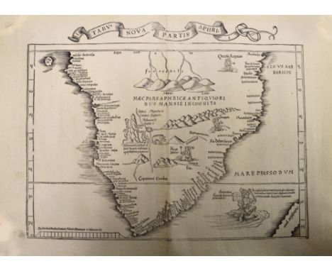
Lot 1074
AFTER MARTIN WALDSEEMÜLLER; 'Tabula Nova Partis Aphri', an early to mid-16th century map of South Africa with Latin text and illustrations, uncoloured, map approx 30 x 42cm, unframed.Provenance: Purchased from Frank R Thorold of Johannesburg in 1997.Additional InformationCentral fold, some foxing, spotting and marks, the right hand side is lifting from the central joint at both the top and the bottom of the vertical fold with a few small surface losses.
![AFTER GUILLAUME SAMSON; 'Iudaea Seu Terra Sancta, In Suas Duodecim Tribus Divisa [...]', a late 18th century copper engraved](https://cdn.globalauctionplatform.com/680b153e-6c63-4eed-ba91-aa0f0118148b/67ab1ad0-9e1b-4364-9846-aa1c011db873/468x382.jpg)
Lot 1075
AFTER GUILLAUME SAMSON; 'Iudaea Seu Terra Sancta, In Suas Duodecim Tribus Divisa [...]', a late 18th century copper engraved hand coloured map of Judea and the Holy Land, cartouche to upper left showing Moses holding the Tablets of Law and cartouche to lower right depicting Adam and Eve in the Garden of Eden, pub. by Jaillot Paris 1677, 52.5 x 84cm, framed and glazed. Additional InformationCentral vertical fold/crease, foxing and spotting throughout, some fading to colours and staining.
Lot 1077
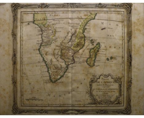
AFTER LOUIS BRION DE LA TOUR; 'Partie de L'Afrique Audelà de L'Equateur, Compremant le Congo, la Cafrerie & C', a mid-18th century copper engraved hand coloured map of Africa, pub. Sr. Desmos Paris 1766, map 23 x 25.5cm, framed and glazed. Additional InformationHeavily foxed and browned, later page no. inscription upper left, central crease/fold.
Lot 1078
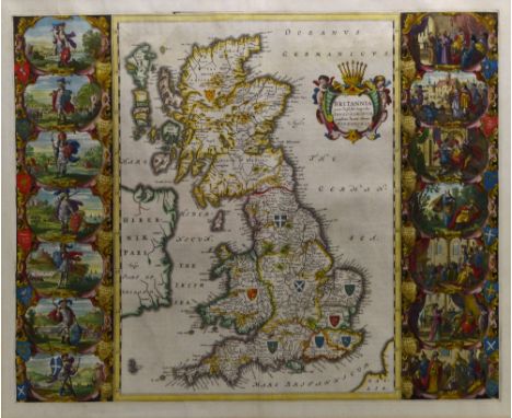
AFTER JAN BLAEU; 'Britannia Prout Divisa Fuit Temporibus Anglo-Saxonum Praesertim Durante Illorum Heptarchia', a mid-17th century copper engraved map of the Saxon Kingdoms of Britain as featured in Volume 4 of 'Atlas Novus' with 14 highly detailed and finely hand-coloured vignettes and further hand-colouring to the map and cartouche, pub. Amsterdam c.1645, approx 41 x 52cm, framed and glazed.Additional InformationCentral fold/crease, some waviness to the paper, some spotting, pronounced crease mark to the lower left of the map and again to the lower left of the left column of vignettes, some further lines or creases, spotting and discolouration however colours remain distinct.

Lot 1079
AFTER HENRICUS HONDIUS; 'Africae Nova Tabula', an early-mid 17th century copper engraved hand-coloured map of Africa with detail of galleons and mythic sea creatures, dark impression, 37.7 x 50.3cm, framed and glazed.Additional InformationA dark impression as stated, central fold/crease with marks following it, spotting and foxing and discolouration throughout.

Lot 1080
AFTER ABRAHAM ORTELIUS; 'Africae Tabula Nova', an early 17th century copper engraved hand-coloured map of Africa from the Spanish text edition of 1612, 37.5 x 50.2cm, framed and glazed.Additional InformationCentral fold/crease, discolouration and foxing, some waviness to the paper, some printing errors, bleeding of text.

Lot 1082
AFTER EDWARD WELLS; 'A New Map of Africk Shewing its Present General Divisions Chief Cities or Towns, Rivers, Mountains &c Dedicated to His Highness William Duke of Gloucester', a circa 1700 copper engraved hand coloured map, R. Spofforth sculp., 36.8 x 50.7cm, framed and glazed.Additional InformationCentral vertical fold/crease, some spotting and foxing particularly to edges, colours remain distinct.

Lot 1083
An 18th century Italian copper engraved hand coloured map of the Cape of Good Hope, 'Carta Geografica Del Capo Di Buona Speranza', 32.5 x 42cm, and a Dutch engraving depicting the Cape of Good Hope, 'Gezigt Van De Kaap De Goede Hoop' with key of landmarks to lower section, approx 26.5 x 36cm, both framed and glazed (2). Additional InformationRegarding the map, some old print marks, some discolouration and spotting, later inscribed 117 to upper right, engraving also with some spotting and discolouration.
![AFTER NICOLAS SANSON; 'A Mapp of the Higher and Lower Aethiopia Comprehending ye Several Kingdomes [...] by Monsieur Sanson G](https://cdn.globalauctionplatform.com/680b153e-6c63-4eed-ba91-aa0f0118148b/48409d90-9c21-4aa0-b433-aa1c011dbfcb/468x382.jpg)
Lot 1084
AFTER NICOLAS SANSON; 'A Mapp of the Higher and Lower Aethiopia Comprehending ye Several Kingdomes [...] by Monsieur Sanson Geographer to ye French King', a late 17th century copper engraved hand-coloured map of Africa, dedication 'To the Right Worshipful S. R. William Glynne of Bissister in Oxfordshire [...]' upper right, Francis Lamp sculp., 29.8 x 40.7cm, framed and glazed. Additional InformationBrowning to paper, foxing, some fading to colours, some waviness to paper and crease/fold marks.

Lot 1085
An unusual and large rectangular coloured map, 'Nyasaland Protectorate Central Africa' printed by Vincent Brooks, Day & Son Ltd of London, with profuse illustrations of native people, landmarks, flora, fauna and travel routes, scale 8.89 miles to 1 inch, 146.5 x 59.5cm, framed and glazed. Additional InformationIn good well preserved condition, colours are strong, only some light waviness but overall in good original condition.
-
109182 item(s)/page