We found 109182 price guide item(s) matching your search
There are 109182 lots that match your search criteria. Subscribe now to get instant access to the full price guide service.
Click here to subscribe- List
- Grid
-
109182 item(s)/page


Lot 79
The Flora Of Sussex Edited by Lieut. Colonel A H Woolley Dod published by The Chatford House Press Bristol 1970 hardback 571 pages with a dust jacket over orange cloth and rear fold out map in very good condition approx 22cm x 14cm. We combine postage on multiple winning lots and can ship worldwide. UK postage from £5.99, EU from £7.99, Rest of World from £9.99.

Lot 164
The Last Moments of Napoleon, a cast bronze figure by Vicenzo Vela (Italian 1820-1891)19th centuryThe bronze figure seated in a chair, brooding over a map of his lost Empire, signed V.VELA and inscribed F BARBIDIENNE, FONDEUR 19cm highFootnotes:Vela exhibited his model at the Salon of 1867. It struck an immediate chord with a public whose anxiety over the eclipse of their country by Prussia was equalled by a nostalgia for the First EmpireEXHIBITED:Waterloo Memorial Museum, 'Napoléon: de Waterloo à Sainte-Hélène, la naissance de la légende,' 5 May to 17 October 2021LITERATURE:Wardropper, I. & Licht, F., Chiselled With a Brush, Italian Sculpture 1860-1925 from the Gilgore Collections, Chicago, 1994, p.36. no.1This lot is subject to the following lot symbols: ** VAT on imported items at a preferential rate of 5% on Hammer Price and the prevailing rate on Buyer's Premium.For further information on this lot please visit Bonhams.com
Lot 145
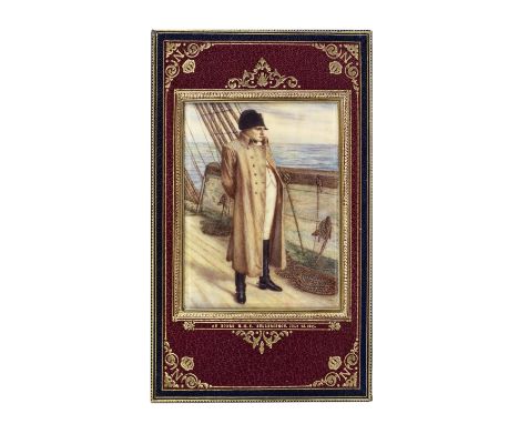
COSWAY-STYLE BINDINGMAITLAND (CAPTAIN F.L.) Narrative of the Surrender of Buonaparte and his Residence on Board H.M.S. Bellerophon; with a Detail of the Principal Events that Occurred in that Ship, between the 24th May and the 9th of August, 1815, FIRST EDITION, EXTRA-ILLUSTRATED, lithographed folding map, extra-illustrated with 42 additional (mostly) engraved plates (some double-page or hand-coloured), later full blue crushed morocco gilt, PORTRAIT OF NAPOLEON ON BOARD H.M.S. BELLEROPHON by ?F.E. Bennett, executed on ivory, (120 x 95mm.) sunk within the front doublure, the covers with elaborate borders enclosing a central lozenge enclosing a coronated 'N' (upper), and Napoleonic bees (lower) motif, spine tooled and lettered in 6 compartments within raised bands, g.e., elaborately tooled red morocco doublures with coronated 'N' motif in corners, watered silk free endpapers, joints very slightly weakened, 8vo (205 x 125mm.), Henry Colburn, 1826Footnotes:The portrait of Napoleon standing on board the deck of HMS Bellerophon on 23 July 1815 is based upon the painting of the Emperor by Sir William Quiller Orchardson, bequeathed to the Tate Gallery in 1880.This lot is subject to the following lot symbols: • Y Ф• Zero rated for VAT, no VAT will be added to the Hammer Price or the Buyer's Premium.Y Subject to CITES regulations when exporting items outside of the EU, see clause 13.Ф This lot contains or is made of ivory. The United States Government has banned the import of ivory into the USA.For further information on this lot please visit Bonhams.com

Lot 129A
CRAAN (W.B.): 'PLAN DU CHAMP DE BATAILLE DE WATERLOO DIT DE LA BELLE-ALLIANCE', AN ENGRAVED FOLDING MAP BY G. JACOWICK AFTER CRAAN, CIRCA 1816; TOGETHER WITH A 19TH CENTURY FRENCH PATINATED AND PARCEL GILT BRONZE EQUESTRIAN FIGURE OF NAPOLEONthe map Rhand-coloured in outline, dissected and laid on linen, with accompanying letterpress 'Notice Historique' (torn into sections) and with original marbled card slipcase, 68.5cm x 56cm overall, Brussels, [c.1816]; the bronze figure on naturalistic oval base, 20cm high, (2)For further information on this lot please visit Bonhams.com


Lot 146
After Samuel and Nathaniel Buck, a small prospect 'The Southeast view of Kydwelly Castle in the County of Caermarthen, in Hogarth frame, together with another original map 'A view of the town and castle of St Augustine (Florida, US) and the English camp before June 20 1740 by Thomas Silver'. Framed and glazed. 19.5 x 37cm and 31 x 18cm approx. (2)(B.P. 21% + VAT)
Lot 407
Box of antiquarian books to include; 'Second edition Cliffe's Book of South Wales, Bristol Channel, Monmouthshire & the Wye' 1848, Welsh language books mostly religious, 'Welsh Country Upbringing; by D Parry-Jones, 'Carmarthen and its Neighbourhood' by William Spurrell, 'Aids to Contentment' by J Morris 1870, leather bound 'Bleak House' Charles Dickens, 'A Garland of Quiet Thought's' 1925, some miniature books including; 'Longfellow' and three leather bound in case published by Griffith and Farran; 'Whispers of Love and Wisdom', 'Fragments in prose and verse' and 'Cut Diamonds' and an Ordnance Survey map of Carmarthen and Tenby etc.(B.P. 21% + VAT)


Lot 156
Two lignum vitae truncheons with turned handles, 38cm and 39cm, a kukri knife with two daggers to scabbard, another knife, also Cooke (HT & Sons), Cooke's Map of Warwickshire with the Existing & Projected Railways......, a mid-19th century map, linen-backed in 35 sections, cl, nd, c1850, bookplate of William Henry Morris.

Lot 113
BOOKS, TAMWORTH INTEREST, two titles, The History of the Town and Castle of Tamworth in the Counties of Stafford and Warwick by Charles Ferrers Palmer, published by Tamworth: Jonathan Thompson, Bookseller, Market Street & London: J.B. and J.G. Nichols MDCCCXIV the book has a hand-coloured map and illustrations, also by the same author, The Wanderings of a Pen and Pencil, written with A. Crowquill and published London: Jeremiah How 1846, the Author was twice elected High Bailiff of Tamworth, together with an Exegesis possibly dating from 1610
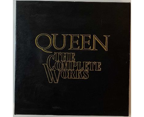
Lot 320
QUEEN - THE COMPLETE WORKS 14 LP BOX SET (QB1). Here we have the extensive 14 LP box-set collection by Queen; The Complete Works (QB1, 1985 UK Limited Edition release on EMI. The set comprises of 11 studio releases plus Live Killers across 14 LPs. Also included is the Complete Works Booklet, Queen Tour Itinerary 1971 to 1985 & Queen Map of the World. The records are in superb Ex/ Ex+ condition. The embossed sleeves are Ex. The box has some minor edge shelf wear, strong VG+).

Lot 9
QUEEN - THE COMPLETE WORKS 14 LP BOX SET (QB1). The fantastic 1985 14 x LP box set from Queen. The set comprises of 11 studio releases plus Live Killers across 14 LPs. Also included is the Complete Works Booklet, Queen Tour Itinerary 1971 to 1985 & Queen Map of the World. Non-numbered edition. The records are primarily in superb Ex+/archive condition with the embossed sleeves typically Ex/Ex+ occasionally with a few light creases. The outer box is in sharp Ex condition with a few light scuffs.


Lot 219
1- Marshall: The Rural Economy of Norfolk, in 2 vols. For G Nicol, 1795, 2nd. Edn. Cont. full calf; rubbed; 2- The Book of Common Prayer. Oxford, at the Theatre, & sold by P Parker, no date (inscription dated 1785). One Engraved title page only, not paginated. Cont. full panelled calf; rubbed, a few pages trimmed at the top; two armorial bookplates; 3- ANOTHER edition. L, J Basket, 1739; bound with the new version of the Psalms of David, 1742. 216pp, cont. full leather with gilt decorations (135x80mm); 4- Paterson: New and accurate description of all the direct and principal cross roads in England & Wales and part of the roads of Scotland. 1808, With a folding map. Cont. half leather, rubbed. (5)Condition report: Map not present. Some staining to the inside. Wear to the outside, please see additional images.

Lot 242
Thomas Moule, Map of Hertfordshire, c.1845, hand coloured, engraved by W. Schmollinger, produced for Thomas Moule's English Counties Delineated, originally issued in 1830, this the final state of the map published in Barclays Dictionary from 1845-1852, 21 x 27 cmCondition report: In good condition, some slight time stainingOverall looks to be in good order. Some losses to the frame.

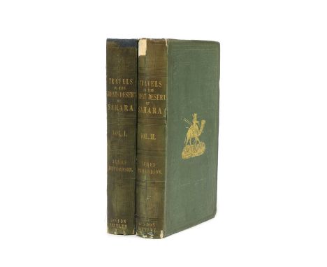
Lot 216
Richardson, James: Travels in the Great Desert of Sahara, in the Years of 1845 and 1846. Containing a Narrative of Personal Adventures, During a Tour of Nine Months Through the Desert, Two volumes. R Bentley, 1848, first edition. With a folding map, 3 plates, plus text illustrations, PP: xxxi, 440; xii, 482, (ii) Adverts. Original gilt pictorial cloth, recased with new endpapers; covers rubbed and with small cuts. (2)

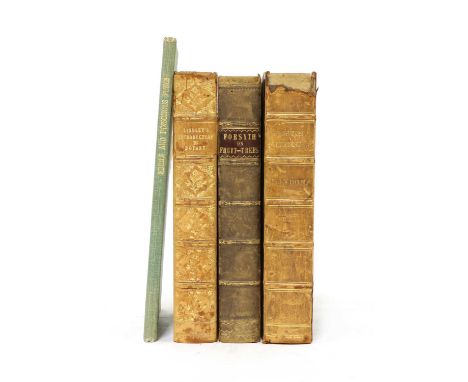
Lot 226
1- LOUDON, F L: Hortus Britannicus A Catalogue Of All The Plants Indigenous, Cultivated In, Or Introduced To Britain, in 2 parts. For Longman, Rees, 1830, 1st. edn. Cont. half leather; rubbed; 2- Forsyth, W: A Treatise on the Culture and Management of Fruit Trees. Longman, 1818, With a portrait frontis plus 13 plates (11 folding). Cont. half leather; rubbed; 3- Lindley, J: An Introduction to Botany. Longman, 1839. With 6 Plates plus text illustrations. Cont. half leather; rubbed; 4- Edible & Poisonous Fungi. Ministry of Agriculture Bulletin #23. 1934. 1- PIDSLEY, WEH: Birds of Devonshire, with a Map and one colour plate. Gibbings, 1891, 1st. edn. Original gilt pictorial cloth; tear to the fold of the map (without loss); 2- Kearton, R: Birds’ Nests, Eggs & Egg-Collecting. Cassell, 1903, with 22 colour plates. Full calf prize binding; little rubbed; small ink stain to one plate. (6)


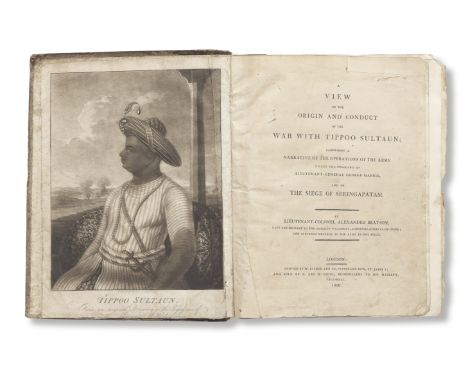
Lot 225
Lt. Col. Alexander Beatson, A View of the Origin & Conduct of the War with Tippoo Sultaun G. & W. Nicol, London, 1800Comprising a Narrative of the Operations of the Army under the Command of Lieutenant-General George Harris, and of the Siege of Seringapatam, 433 pp., engraved portrait frontispiece, 4 folding engraved maps and plans (one hand-coloured), two folding tables, contemporary calf 4to, 270 x 220 mm.Footnotes:The tables and maps comprise:The Order of Battle of the army under the command of General Harris.A Plan of the Attack upon the North West Angle of Seringaptam.A Sketch of the Environs of Seringapatam.A Map of the Dominions of the late Tippoo Sultaun, exhibiting their Partition among the Allied Powers (hand-coloured).A Table of Revenues.An Abstract of Tipu's territories and their overseers, population, etc.Colonel Beatson was 'late aide-de-camp to the Marquis Wellesley, Governor-General of India, and Surveyor-General to the Army in the Field'.This lot is subject to the following lot symbols: •• Zero rated for VAT, no VAT will be added to the Hammer Price or the Buyer's Premium.For further information on this lot please visit Bonhams.com


Lot 637
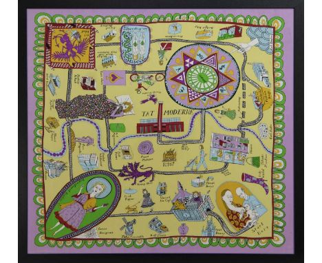
* GRAYSON PERRY RA (BRITISH b. 1960),100% SILK SCARF100% silk, produced for the Tateimage size 91cm x 88cm, overall size 95.5cm x 95.5cm Framed and under glass.Note: In the second world war pilots were given maps printed on silk to help them escape if they were shot down over enemy territory. This scarf is a social and cultural map to help aspiring artists navigate the hostile territory on their way to being accepted by the establishment. Many famous artists who can help them live along the route.


-
109182 item(s)/page