Mixed group of items,Two rolls of Tartan tailoring fabric, together with a vintage fringed silk shawl, a length of 19th century silk bobbin and other lace trims, a First World War souvenir handkerchief with map of Egypt and the Allies in uniform (including Japan) a small Chinese embroidered panel, a patriotic Union Jack silk handkerchief and two others of the Armed Forces, a 1950's Cliff Richard scarf and two vintage Schaeffer pens and playing cards.
We found 109198 price guide item(s) matching your search
There are 109198 lots that match your search criteria. Subscribe now to get instant access to the full price guide service.
Click here to subscribe- List
- Grid
-
109198 item(s)/page
Eight vintage keepalls and carryalls by Stratton, Kigu, Volupte Flato and Evans, two decorated with bold rhinestone motifs, one in silk, another with a map of Cuba, the remainder in gilt metal . Overall in good condition, with some wear. Please refer to additional photos for further information
Bradshaw's Railway Manual, Shareholder's Guide and Official Directory for 1884;..., volume 36, 1884, large black and white folding map of Great Britain to front, first upper left panel torn, plus folding maps of India to pp. 375 and Belgium and France to rear, black & white advertisements to front and rear, modern endpapers, some minor toning, rebound with modern green cloth spine retaining original gilt-decorated green cloth boards, 8vo (1)
MAP OF THE CITY OF DUBLIN, black and white, engraved from the actual survey for the picture of Dublin, published by Baldwin, Cradock and Joy London, September 1821 and engraved by Sidney Hall Brewery Street Bloomsbury, 18.5" (47cm)h x 19.5" (49cm)w; together with a coloured print after George Moreland, "Figures with Donkeys by a Cottage, unframed. (2)
Ephemera - Local Interest - The Bemrose Map of Derby, Showing Parliamentary And Ward Boundaries, Revised 1956, 6:1 scale, sixteen-fold map, 76cm x 100cm; The Cow and Gate Happy Family Game, by Smiler, boxed; Cigarette Cards - Proverbs, by Ardath Tobacco Co. Ltd; sepai photograph, Brighton Hove Boys Football Team - English Schools Shield Finalists - 1927 & 28; Essex, a two-page map, emgraved and published by Pigot & Co, engraving, hand-coloured in places, 29cm x 41cm; English School (early 20th century), Shepherd and His Sheep, etching, 24.5cm x 35.5cm David Rampling, by and after, Owl, offset print, mounted (qty)
Baedeker (Karl). Egypt. Handbook for Travellers, 2nd edition, revised and augmented, 1885, folding colour maps (one or two slightly frayed), illustrations, front hinge a little tender, original red cloth, spine a little faded with splits to upper joint, 8vo, together with Calignani's New Paris Guide, Paris, August 1838, folding map with outline colour at end, some spotting, contemporary morocco, spine rubbed and chipped, some edgewear, 8vo, plus Guide de l'Etranger dans Paris et ses Environs, 5th edition, Paris, Grand-Hotel, 1875, illustrations and advertisements at end, some spotting, ink signature of M. Konck, par l'Administrations du Grand-Hotel to title, original cloth, spine faded, 8vo, with other Baedeker European guides and Guida d'Italia, some duplicates etc (58)
Egerton (Francis). Journal of a Winter's Tour in India: With a Visit to the Court of Nepaul, 2 volumes, 1st edition, 1852, wood-engraved frontispieces, folding map, illustrations, bound without advertisements, a little light spotting, bookplates, contemporary green calf gilt, spines a little darkened and rubbed, 8vo Yakushi E24. (2)
American Civil War. Stanford (Edward, publisher), Stanford's Map of the Seat of War in America, sheet 1 (only), published August 21st, 1861, lithographic map with contemporary outline colouring, old folds, partially split along central fold, slight marginal fraying, some marginal dust soiling and spotting, 680 x 550 mm (1)
Bedfordshire. Speed (John), Bedford Shire and the situation of Bedford described with the armes of thos honorable familyes that have borne ye titles of dukes and earls thereof, published George Humble, circa 1627, uncoloured engraved map, inset town plan of Bedford, central fold repaired and strengthened on verso, slight staining to central fold, one rust hole affecting image, 385 x 515 mm, English text on verso, together with, Jansson (Jan), Holy Iland, Garnsey, Farne [and] Jarsey, published Amsterdam, circa 1648, four engraved maps on one sheet (as published), contemporary outline colouring, 410 x 515 mm, Latin text on verso, with Morden (Robert), The County Palatine of Lancaster, [1695 or later], hand coloured engraved map, slight toning to central fold, slight spotting to margins, 415 x 365 mm, plus, Blaeu (Johannes & Pont Timothy), Carricta meridionalis, The South part of Carrick, circa 1654, hand coloured engraved map, small repair at base of central fold, slight 'smudging' to watercolour around the cartouche, 385 x 525 mm, German text on verso, together with two John Ogilby road maps and a John Speed of Merionethshire and an uncoloured engraving of The Battle of Culloden published by Laurie and Whittle, various sizes and condition (8)
Bristol. Meisner (Daniel), Brightstowe in Engellandt, circa 1630, uncoloured engraved town plan, printers fold, 95 x 145 mm, together with Greenwood (C. & J.), Map of the County of Northampton from an actual survey..., 1830 [and] Map of the County of Worcester from an actual survey..., 1830, two engraved maps with contemporary hand colouring, calligraphic title, table of explanation, compass rose, uncoloured engraved vignette of Peterborough cathedral and Worcester cathedral respectively, each approximately 600 x 700 mm, with Blome (Richard), A Mapp of Warwickshire with its hundreds, circa 1681, hand coloured engraved map, 320 x 265 mm, plus Bowen (Emanuel), Staffordshire drawn from the best authorities, published in 'The Universal Magazine', 1755, uncoloured engraved map, old folds, 200 x 175 mm, with another three maps similar (8)
Gerning (Johann Isaac von). A Picturesque Tour Along the Rhine, from Mentz to Cologne: With Illustrations of the Scenes of Remarkable Events and of Popular Traditions, Ackermann, 1820, slight staining to title page, dedication and list of subscribers, 24 aquatint plates with contemporary hand colouring (complete as list) folding engraved map with contemporary outline colouring bound at rear, slight staining to gutter, occasional light offsetting, early 20th century half sheep, scuffed and bumped at extremities, folio Abbey Travel 217. (1)
British Isles. Wyld (James), Railway map of England, Wales and Scotland, Drawn from the triangulation of the Ordnance Survey, the survey of the Railway Companies, and other information shewing the lines of Railways, the Inland Navigation, Great and Cross Roads, Cities, Market Towns & Villages, 1889, very large engraved map with contemporary outline colouring, sectionalised and laid on linen, on two sheets, numerous inset railway gradient profiles, marbled endpapers, each sheet approximately 1000 x 1365 mm, contained in a contemporary cloth slipcase with publisher's printed label to upper board, together with Arrowsmith (Aaron), Map of the Railways, showing the various stations with the Hills, Rivers, Canals and Principal Roads of England and Wales, also exhibiting most of the places whose situation has been ascertained by the stations and intersections of the Trigonometrical survey, sold by J. Gardner, 1840, large engraved map with contemporary outline colouring, sectionalised and laid on linen, on four sheets, slight offsetting, each sheet approximately 900 x 730 mm, marbled endpapers, contained in a contemporary green morocco slipcase with gilt title to spine, heavily rubbed and worn, lacking 'envelope style' cover (2)
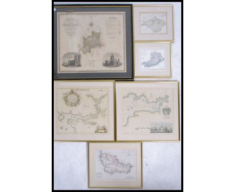
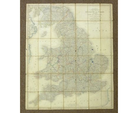
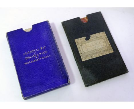
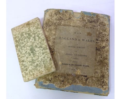
British Isles. A collection of eight folding maps, 18th & 19th century, including Faden (William), The Roads of Great Britain, 1781, engraved map with contemporary hand colouring, sectionalised and laid on linen, inset map of Scotland, some staining, 740 x 595 mm, later ink ownership signatures to verso, contained in contemporary marbled card slipcase with booksellers label with near contemporary manuscript title to upper board, worn and frayed, with another copy but with the linen worn and split along old folds, together with Paterson (Daniel), Bowles's New Pocket map of England & Wales with the addition of new roads and improvements, published Carington Bowles, circa 1790, engraved map with contemporary outline colouring, sectionalised and laid on linen, inset map of the Isles of Scilly, toned overall, splits along linen folds, 600 x 530 mm, contained in a contemporary marbled card slipcase with publisher's printed labels to upper and rear boards, worn, with Mogg (Edward), Mogg's map of Steam Navigation. Map of the United Kingdom or Water itinerary of Great Britain & Ireland with the adjacent parts of the continent from Amsterdam to Paris and Brest..., Jany. 1st. 1841, engraved map with bright contemporary hand colouring, sectionalised and laid on linen, inset map of the Shetland Islands, compass rose and table of British counties, 775 x 610 mm, printed instructions on endpapers, contained in a contemporary card slipcase with printed label to upper board, frayed at extremities, plus Smith (Charles), A New Map of England and Wales comprehending the whole of the Turnpike roads with the great rivers and navigable canals, 2nd edition, 1808, engraved map with contemporary hand colouring, sectionalised and laid on linen, 570 x 460 mm, publisher's card slipcase with printed label to upper board, some wear to extremities, and Cary (John), A New Map of England from the latest authorities, 1818, engraved map with contemporary hand colouring, sectionalised and laid on linen, slight wear to linen folds, 565 x 485 mm, marbled endpapers, together with, Kerr (Thomas & Co., publishers), England, circa 1860, engraved map with contemporary hand colouring, sectionalised and laid on linen, dust and finger soiled, 570 x 470 mm, contemporary cloth boards with publisher's label to upper cover, spine frayed with slight loss, boards stained, and Smith (Charles), Smith's New Map of England and Wales with part of Scotland, including the Turnpike and principal Cross roads..., 1841, engraved map with contemporary outline colouring, sectionalised and laid on linen, toned overall, several ink stains affecting image, some spotting, 1150 x 945 mm (8)
*British Isles. Speed (John), The Kingdome of Great Britaine and Ireland, published John Sudbury & George Humble, circa 1627, hand coloured engraved map, inset views of London and Edinburgh, inset map of the Orkney islands, slight creasing, central fold partially split and repaired on verso, 385 x 505 mm, English text on verso, mounted, framed and double glazed (1)
British Isles. Visscher (Nicolas), Magnae Britanniae tabula; Comprehendens Angliae, Scotiae, ac Hiberniae regna..., published Amsterdam, [1694 or later], hand coloured engraved map, central fold and margins repaired on verso, old fold repaired on verso, 475 x 570 mm, Dutch text on verso R. W. Shirley. Printed Maps of the British Isles 1650 - 1750. Visscher 4 state 2. (1)
British Reformation Society. A Map shewing the situation of each Roman Catholic Chapel, College or Seminary, throughout England, Scotland, and Wales. According to published accounts and also the present stations of the Reformation Society. To Jany. 1833, engraved map with contemporary hand colouring, old folds, slight spotting and offsetting, inset map of the county of Lancashire, 580 x 370 mm A scarce map; published by the British Reformation Society in 1833, only four years after Parliament had passed the Roman Catholic Relief Act 1829. The Act finally lifted the long-standing political and civil restrictions on Roman Catholics in England & Wales and Scotland (but notably not in Ireland). Most of the Protestant population were indifferent to the new freedoms, but the more radical Protestant elements - led by the Reformation Society - who were opposed to Catholic Emancipation, were vociferously vocal and sought for a time to reverse the reforms. They published this map as a form of propaganda to show the spread of Catholicism throughout the nation. The map includes the locations of Reformation Society Stations which were set up to supposedly place a check against Catholic activities. A somewhat sinister anti-Catholic map, demonstrating the religous intolerance which still abounded in the 19th century. (1)
Cartographic curiosity. Afbeeldinge van't zeer vermaarde Eiland Geks-Kop..., c.1720, unattributed engraved map of the 'Island of the Fool's Cap', two columns of poetic text below image, slight spotting, old folds, 295 x 235 mm An uncommon allegorical map which refers to American Pyramid schemes and in particular the 'Mississippi Bubble'. A project that met a similar fate to the 'South Sea Bubble' but was promoted in France by a Scottish economist called John Law. The collapse of the project destroyed the French 'Banque Generale'. The financial mayhem that resulted meant that Law - in fear of his life - had to flee the country disguised as a woman. (1)
*Commemorative Plate. Victoria, Queen & Empress, Jubilee year, 1887, octagonal plate illustrated with transfer illustrations of the Queen and the Prince of Wales, heraldic crests of Australia, Canada, Cape Colony and India and a hemispheral map of the world highlighting the British Empire, with figures illustrating the balance of trade within the empire, gilding to rim is worn, produced by Nestle and Huntsman, pattern number 63164, 240 mm diameter (1)
England & Wales. Knipe (J.A.), Geological & Mineralogical Map of England & Wales, with Parts of Scotland, Ireland & France, showing also the Inland Navigation by Means of Rivers & Canals, with their Elevation in feet above the Sea, The Rail Roads & Principal Roads, published J. A. Knipe, Jany. 1st. 1845, engraved map by John Dower, contemporary hand colouring, sectionalised and laid on linen, calligraphic title, inset geological cross sections and table of explanation, contemporary ownership signature to upper border, old drawing pin marks to margins, 1100 x 780 mm, bordered in green silk, contemporary blind stamped morocco slipcase with gilt title to upper board, sellotape repair to base of slipcase, slight wear to extremities (1)
England & Wales. Ramsay (Andrew C.), Geological Map of England & Wales, 4th edition, published Edward Stanford, 1877, lithographic map with contemporary hand colouring, sectionalised and laid on linen, slight off setting, 940 x 800 mm, contained in publisher's blue cloth gilt slipcase, slight wear to extremities, together with Wyld (James), Map of the United Kingdom of Great Britain and Ireland, circa 1875, engraved geological map with contemporary hand colouring, sectionalised and laid on linen, inset map of the Shetland Islands, slight dust soiling, 490 x 380 mm, marbled endpapers, contained in publisher's cloth slipcase with printed label to upper board, slight loss to label, later pencil title to label, additional manuscript label to spine (2)
England & Wales. Andrews (John), A New Physical, Historical & Political Map of England and Wales from actual survey & Astronomical Observations of the Royal Society, published J. Stockdale, 1807, large engraved folding map with contemporary outline colouring, sectionalised and laid on linen, inset map of the Isles of Scilly, sectionalised and laid on linen, slight overall toning, slight dust soiling, 1580 x 1320 mm, contained in publisher's marbled card slipcase with printed paper label to upper board, slipcase worn and rubbed with slight loss to label and extremities, together with Bowles (Carington), Bowles's New and Accurate map of England and Wales, comprehending all the cities, boroughs, markets and sea port towns..., 1788, large engraved map with contemporary hand colouring, inset map of the Scilly Isles, sectionalised and laid on linen, some spotting and dust soiling, 1305 x 1015 mmm contained in a contemporary marbled card slipcase with publisher's label to upper board, worn and frayed, The first map described was first published in 1786 and the title retains this date. The Stockdale imprint and later dates are found twice: once below the map outside the margins and again within the scaled border. (2)
England & Wales. Metellus (Johannes), Anglia Lati Ingllatera, Itali Engellandt ger Angleterre Gal, published Cologne, circa 1579, engraved map with contemporary hand colouring, some staining and dust soiling, largely confined to margins, 140 x 200 mm Scarce. R. W. Shirley. Early Printed Maps of the British Isles, 1477 - 1650, no. 123(a). (1)
England & Wales. Munster (Sebastian), Das Engleeand mit dem anstossenden Reich Schottland so vor zeiten Albion und Britannia haben geheissen, [1578], uncoloured woodcut map orientated to the east, slight water staining largely confined to margins, 265 x 345 mm, German text on verso R. W. Shirley. Early Printed Maps of the British Isles, 1477 - 1650, no. 120. (1)
England & Wales. Faden (William), The Roads of Great Britain, 3rd. edition, 1795, engraved map with contemporary outline colouring, sectionalised and laid on linen, inset map of Scotland, slight dust soiling, 735 x 580 mm, contained in a contemporary marbled card slipcase, worn and frayed, together with, Mogg (Edward), A New Travelling Map of England , Wales and Scotland; drawn from all the surveys which have hitherto been made of particular counties..., published Edward Mogg, March 1st. 1833, engraved map with contemporary hand colouring, sectionalised and laid on linen, inset map of Scotland, near contemporary ownership signature to verso of map and on the endpapers, 750 x 620 mm, contained in a contemporary marbled slipcase with publisher's printed label to upper board, label with two further manuscript ownership signatures, frayed and worn at extremities, with Smith (Charles), Smith's Map of England & Wales containing the whole of the Turnpike roads, Rivers and Canals..., 1836, engraved map with contemporary hand colouring, sectionalised and laid on linen, 785 x 620 mm, plus Coltman (Nathaniel), Laurie and Whittle's New Map of all the Coach Roads both direct and cross of England & Wales..., published Robt. Laurie & James Whittle, April 12th, 1809, engraved map with contemporary outline colouring, sectionalised and laid on linen, 780 x 625 mm, marbled endpapers, and Betts (John), Betts's New Map of England & Wales compiled from the latest Parliamentary documents, 1845, engraved map with contemporary outline colouring, sectionalised and laid on linen, slight staining and dust soiling, 770 x 655 mm, contained in a contemporary card slipcase, publisher's printed label torn and defective, with another fifteen folding maps of England & Wales similar, including examples by Mogg, Bartholomew, Walker, Lizars, Kitchin, Rock, Dower, Walker, Airey, Grant, Betts, Bacon and Ordnance Survey, various sizes and condition (20)
England & Wales. Seaton (Robert), This New Plan of England and Wales, with the Adjacent Countries, compiled by Surveyors employed in the Ordnance Department, is Respectfully Dedicated to the King by his most Obedient Servant & Geographer, circa 1830, large folding engraved map with original hand colouring, sectionalised and laid on linen, large vignette engraving of Windsor Castle, margins decorated with engraved portraits of famous Britains, some old sellotape repairs to verso of map, marbled endpapers, 1200 x 960 mm, contained in a modern cloth slip case with red morocco gilt label to upper board (1)
England & Wales. Kitchin (Thomas), A New Map of England & Wales. Drawn from several surveys &c on a new projection, corrected from astronomical observations & the places marked where the observations were made, published Laurie & Whittle, 12th May 1794, engraved map with contemporary outline colouring on four sheets, not conjoined, inset map of the Isles of Scilly, old folds, some abrasion with slight loss in the cartouche, each sheet approximately 650 x 550 mm (1)
Europe. Lehmann-Dumont (Karl), Humoristische Karte von Europa im Jahre 1914, published Dresden, 1914, colour printed photolithographic allegorical map, inset map of Japan, old folds, 350 x 490 mm An uncommon allegorical depiction of Europe, with the bias on Germany and Prussia. Undoubtedly published for amusement it concentrates on the national characteristics and the foibles of each nation, but there is also a more disturbing element of propoganda. The date of publication and the depiction of national stereotypes will prove to be highly prophetic of the carnage that was shortly to engulf the continent. In unusually fine condition. (1)
Europe. Rose (F. W.), Serio-Comic War Map for the year 1877, published G. W. Bacon & Co., 1877, colour lithographic map with explanation to lower right, 425 x 565 mm Rose's 1877 map published in the midst of the Russo-Turkish War shows Russia creeping like an octopus across the globe, its tentacles grasping at land on all sides. While the other countries are illustrated as people, Russia is depicted as something alien and monstrous. The Map which began an arresting visual trend of cartographic cephalopods. (1)
Florence. Ruggieri (Ferdinando), Pianta del La Citta di Firenze, 1755, uncoloured engraved city plan, orientated to the south, sectionalised into four sheets and laid on linen, edged in pink linen, 510 x 685 mm An uncommon map of Florence by the architect Ferdinando Ruggieri (1691-1741), his only foray into cartography, and first issued in 1731. It is decorated with an ornate title cartouche, the city arms and four panels containing statistics of each quarter. (1)
Folding maps. Walker (J & C), A collection of thirty-one British county maps, circa 1845, engraved folding maps, sectionalised and laid on linen, all with contemporary outline colouring, occasional duplicates, all in contemporary cloth boards with printed label to upper siding, each map approximately 335 x 405 mm The maps comprise of:- Hampshire, Durham, Northamptonshire, Cornwall, West Riding Yorkshire, North Riding Yorkshire, Essex, Cumberland, Leicestershire, Herefordshire, Middlesex, Northumberland (2), Cambridgeshire (2), Lincolnshire, Gloucestershire, Bedfordshire, Hertfordshire, Nottinghamshire, Somerset, Westmorland, Huntingdonshire, Devonshire (2), Worcestershire, Norfolk, Staffordshire, Shropshire, Scotland [and] England. (31)
Herefordshire. Saxton (Christopher), Frugiferi ac Ameni Herefordiae comitatus delineatio, [1579], engraved map by Remigius Hogenberg, contemporary hand colouring, elaborate cartouche and with the arms of Thomas Seckford, dividers and mileage scale, central fold strengthened on verso, one repaired closed tear affecting image, some dust soiling largely confined to margins, 370 x 500 mm This copy has the 'bunch of grapes' watermark, widely considered to be indicative of one of the earliest states of Saxton's maps. (1)
Hoskyn (E.L.). Stories of Old..., containing twelve full-page illustrations in colour by L.Tennant, published Adam and Charles Black, 1912, twelve (complete as list), colour printed allegorical maps by Lillian Tennant, each showing a historical or mythological character set within a map of the country of the story's origin, one map (Wales) detached, some staining and finger soiling throughout, pencil annotations to front endpaper and front pastedown, hinges and joints weak, publisher's decorative boards with colour printed panel to upper cover, upper siding cracked, 4to, together with, Sayer (J. P.),12 original lithographic prints comprising the first twelve up to October 1947 of the series of Picture Maps of London, published George Newnes, 1947, colour printed pictorial maps and aerial prospects of parts of London, including two loosely inserted duplicate maps (Mayfair and Kensington Gardens), publisher's printed paper wrappers, oblong 8vo, with five 'Dunlop Pictorial Maps' of England and Scotland, each map 220 x 205 mm with descriptive text, plus A Coronation Picture Book, published by Dunlop, circa 1953, 'The Pageant of the Highways', oblong 8vo (8)
Huntingdonshire. Gordon (William), An Accurate Map of the County of Huntingdon actually survey'd after a new method in the years 1730 & 1731, [1731], engraved hand coloured map, engraved by Emanuel Bowen, one sheet only from Gordon's large scale map of Huntingdonshire, central fold with some cracking and splitting, professionally repaired on verso, 500 x 600 mm, together with another twenty maps of Huntingdonshire, including examples by Smith, Cary, Seller, Badeslade & Toms, Phillips, Morden, Owen & Bowen, Moll, Moule, Rocque, Bowen, Kitchin and Pigot/Slater, some duplicates, various sizes and condition, together with Bleau (Johannes), Comitatus Northantonensis vernacule Northamptonshire, published Amsterdam, circa 1648, engraved map with contemporary hand colouring, 420 x 500 mm, French text on verso, with Saxton (Christopher & Kip William), Suffolciae comitatus cuius populi..., [1637], uncoloured engraved map, old folds, laid on later paper, 280 x 385 mm, plus Morden (Robert), Lincolnshire, circa 1705, uncoloured engraved map, old fold, 225 x 175 mm (24)
Kingston Upon Hull. Wilkinson (George), This trigonometrical plan of the Town, Port and Harbour of Kingston upon Hull including the environs of Sculcoates, North and South Myton, Drypool &c. &c. from actual survey..., published Goddard and Lancaster, September, 1848, large lithographic map with contemporary outline colouring, sectionalised and laid on linen, manuscript presentation inscription to Mr. Huffam from Mr. Goddard, vignette of 'The New Passenger Station' some mould and waterstaining, 955 x 1410 mm, contained in a modern red cloth slipcase with morocco gilt label to spine A scarce and large scale plan of Hull. (1)
Leeds. Fowler (Charles), Plan of the Town of Leeds and the environs; including Woodhouse Carr, Knostrop, Hunslet, Holbeck and New Wortley..., 1831, engraved map with contemporary outline colouring, sectionalised and laid on oil cloth, vignette view of the western entrance to Leeds and a vignette of Jefferies' Plan of Leeds, compass rose and a table of explanation, 575 x 815 mm, contained in a contemporary green blind stamped morocco slipcase with printed label to upper board (1)
Leeds. Martin (S. D.), Map of the Country extending ten miles round Leeds, including Wakefield, Bradford, Dewsbury, Otley, Harewood, Aberford & Castleford, shewing all the Parish and Township Boundaries &c., ..... re-surveyed & Corrected to January 1st. 1849 by Martin & Fox, Surveyors, Leeds, large folding engraved map with contemporary hand colouring, sectionalised and laid on linen, uncoloured vignette of Kirkstall Abbey, table of explanation and compass rose, 115 x 1230 mm, contemporary green morocco gilt boards, retaining original metal clasp, worn and frayed, spine partially lacking, upper board detached (1)
Baker (Samuel White). Ismailia. A Narrative of the Expedition to Central Africa for the Suppression of the Slave Trade, 2 volumes, 1st edition, 1874, portrait frontispieces, folding map (with closed tear), maps and illustrations, some light spotting, armorial bookplates of Sir W.G. Gordon Cumming, top edge gilt, contemporary brown morocco, edges a little rubbed, 8vo, together with Wilkinson (Sir J. Gardner), Dalmatia and Montenegro: With a Journey to Mostar in Herzegovina, and Remarks on the Slavic Nation; the History of Dalmatia and Ragusa, 2 volumes, 1st edition, 1848, seven tinted lithographed plates (volume I folding frontispiece detached), folding map, two folding tables, wood-engravings, a few leaves detaching, bookplates, volume I front hinge breaking, original cloth, lacking most of volume I spine, volume II spine with tears, some clear tape residue, 8vo, with two others: David Livingstone's Missionary Travels and Researches in South Africa, 1857 (rebound in later cloth with press cuttings front and rear) and Mary H. Kingsley's Travels in West Africa. Congo Francais, Corisco and Cameroons, 1897 (6)
Johnston (Alexander Keith). The Royal Atlas of Modern Geography, new edition, published W. & A. K. Johnston, 1878, additional half title, dedication and preface, numerous engraved maps with contemporary outline colouring, endpapers and preliminaries, torn and frayed, slight dust soiling, hinges and joints weak, all edges gilt, contemporary half morocco gilt, worn and frayed, folio, together with Handy Royal Atlas of Modern Geography, 1889, title, dedication and preface, numerous engraved maps with contemporary outline colouring, all edges gilt, publisher's half morocco gilt, sidings stained, folio, with another copy similar, with, Bacon (G. W., editor), New large-scale atlas of the British Isles from the Ordnance Survey, 1892, title and preface, numerous double page colour lithographic county, regional and town plan maps, all edges gilt, publisher's half morocco gilt, worn and frayed, folio, plus Bartholomew (J. G.), The Royal Atlas of England and Wales, published George Newnes Limited, circa 1900, numerous colour lithographic maps, front endpaper detached, publisher's half morocco gilt, worn and frayed, folio, and Bevan (G. Philips), Royal Relief Atlas of all parts of the World, 3rd edition, published George Philip & Son, 1885, thirty-one (complete as list) colour printed maps, including twenty-five relief maps with raised surface to indicate mountains or hills, all with accompanying text on verso, each presented on a thick card frame, map of New Zealand with long closed tear affecting image, hinges and joints weak, publisher's half morocco gilt, spine chipped with loss at head and foot, worn, 4to, with another seven atlases similar, mixed bindings, mostly 4to and folio Sold as a collection of maps, not subject to return. (13)
Lisbon. Seutter (George Matthaus), Lisabona magnificentissima regia sedes Portugalliae et florentissimum Emporium ad ostia Tagi situm..., circa 1730, engraved city plan with contemporary hand colouring with an uncoloured prospect of the city below the map, slight fraying to margins, 495 x 575 mm (1)
-
109198 item(s)/page