

and some other items. All Dutch language, mostly 1930s but also incl. earlier publications. (1) In de duinpan. Tweede druk. Koog aan de Zaan, Noord-Hollandse Propaganda-Commissie van de Algemene Nederlandse Geheel-Onthouders Bond, n.d. (ca. 1935), 12 p., 4 ills., orig. stapled (sl. foxed/ browned) pictorial wr. Extremely rare sm. publication, w. amazing front wr. design. (2) Nederlanders in Spanje. Geronseld? Amst., Agentschap Amstel, n.d. (ca. 1937), 16 p., orig. wr. (w. folds). (3) Fascisme of socialisme. Wat eischt het gemeenschapsbelang? Feiten ter overdenking. N.pl., Ned. Vereeniging van Spoor- en Tramwegpersoneel, n.d. (ca. 1938), 16 p., orig. stapled woodcut wr., obl. 8vo. Final page: "Uw antwoord? N.V.V. (and) S.D.A.P. Geen fascisme maar Socialisme!" (4-5) Een heilige ontevredenheid. By T.T. de W. Van breken en bouwen. By S.H. v. G. Amst., Bond van den Soc. Dem. Vrouwenclubs, n.d. (ca. 1931-33), 2 vols., 16 and 8 p. (incl. wr.), orig. stapled wr. w. lithogr. ills. by A. Funke Küpper. Very rare. (6) Van een belangwekkend bedrijf. Hoe het werkt en groeit. Amst., De Arbeiderspers, 1932, (16) p., printed in black, blue and yellow, w. map and ills., orig. thread-bound wr. Very nicely designed publication on de Arbeiderspers. (7) Viruly, A. Ons land en het geweld. Amst., Contact, 1938, 30 p., orig. wr. printed in blue and orange des. by Brögel. (8) Kamerverkiezing 1933. Stemt op de S.D.A.P. Het wonder-biljet zorgt dat het zoo wordt: stemt rood! Movable board propaganda card, 9 x 8.3 cm, w. turnable circular disk behind a square, printed in red and black, in envelope w. the printed text "Op 't drukwerk in dit zakje staat voor U een hééle goede raad". Extremely rare. -and approx. 59 others. (total approx. 65)
We found 108737 price guide item(s) matching your search
There are 108737 lots that match your search criteria. Subscribe now to get instant access to the full price guide service.
Click here to subscribe- List
- Grid
-
108737 item(s)/page
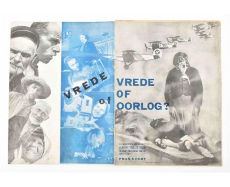
16 augustus te Amersfoort Landdag voor de vrede en voor de erkenning van de Sowjet-Unie. Amst., V.V.S.U. (Veren. van Vrienden van de Sowjet-Unie), n.d. (1936), (16) p., photogr. and other ills., map, plan and score, orig. photomonotage wr. by K. Vanek (=H. Leupold), 4to. Stained copy, wr. sl. wrinkled and lacking staples. Very rare publication w. impressive wrappers. (2) Struik, A. Het vijfjarenplan als socialistisch offensief. Amst., "Agentschap Amstel", 1931, 32 p., photogr. ills., orig. stapled photomontage wr. signed "montage ar.fot 1" (N. de Haas). Wr. splitting at foot of spine. (3) Idem (introd.). Triomf van het socialisme. De weg tot de klassenlooze maatschappij. Het tweede vijfjarenplan van de Sowjet-Unie. Ibid., idem, (1932), 32 p., w. ills., orig. stapled photomontage wr. w. "(ar)fot 2" (C. Oorthuys) in lower right corner. -and 2 similar others, one w. wr. signed "Brögel". (total 5)

van den Nederlandschen Bond van Jongelingsvereenigingen op Gereformeerden Grondslag, op woensdag 29 mei (...) en op Hemelvaartsdag 30 mei 1935. Rott., T. de Vries Dz. for gereformeerde Jongelingsbond, 1935, 40 p., w. double-p. map, photogr. ills., orig. stapled photomontage wr. by W. Brandenburg (signed in the technique), large 8vo. Front wr. w. central crease and foxed in top margin, spine rubbed. (2) Nathans, N. Spanje. Amst., N.V. de Arbeiderspers, 1936, 16 p., orig. stapled photomontage wr., large 8vo. S. Imperfections. Very rare. (3) Zwartbroek, G.J. S.O.S. VARA! Verdedigingsrede uitgesproken op de vergadering van den verenigingsraad van de VARA op 28 April '34 tegen zijn royement als VARA-lid. N.pl., n.publ., 1934, 30,(1) p., orig. stapled photomontage wr., large 8vo. -and 3 others w. nice photomontage wr. (1x monogrammed "GP" and 1x monogrammed "W"), publ. by the Arbeiders Jeugd Centrale. (total 6)

(1) De haven van Amsterdam. Fold. flyer printed in blue, red and black, unfolded measuring 23.5 x 75 cm, ca. 1930, one side showing a map, the other side w. maps, photogr. and text, des. by Cohen, monogrammed multiple times. Sm. tear on fold. Striking design by Cohen. (2) The same fold. flyer but w. the text in French and the monogram of Cohen only appearing once. (3) Amsterdam. All-round port for general and bulk cargo. Centre of international air-traffic. Fold. flyer printed in blue, black and red, unfolded measuring 21.5 x 90 cm, printed by Stadsdrukkerij Amsterdam, ca. 1930, one side w. general explanatory text in Dutch, French, German and English and photogr. ills., the other side w. maps, statistics and ill., des. by Cohen, signed "Fré Cohen Fec." Some tears on folds and sm. dam. spots. (4) Le port maritime et le port aérien d'Amsterdam. Amst., imprimerie Municipale for the Municipalité, (1930), 28 p., photogr. ills., col. ills. and orig. stapled photomontage wr. printed in blue, red and black des. by Cohen (monogrammed on front wr.). -and 1 smaller flyer des. by the same. (total 5)

Comprises 17 picture postcards, 15 cut out advertisements, var. numbers of the periodicals Wereldpost (3x, 1923), Succes and Auto-Kampioen (11x), menu cards, programmes, travel brochures, etc. Incl. a.o.: (1-11) Auto-Kampioen. Weekblad voor auto- motor- en luchtoerisme. Uitgave van den Kon. Ned. Toeristenbond A.N.W.B. Year 29, nr. 46, year 30, nr. 8, 12, 24, 32, 33, 50 and 52, year 31, nr. 21 and 47, and year 32, nr. 4 (numbers 1509, 1523, 1527, 1539, 1547, 1548, 1565, 1567, 1588, 1614 and 1623). The Hague, 16 Nov. 1935 - 22 Jan. 1938, w. continuous pagination, num. ills. and advertisements, orig. wr. by Lavies (a.o.?), some signed by Lavies in the technique. Sm. defects. Good run. (12) N.V. Nederlandsche Huistelefoon Mij. 's-Gravenhage. Trade catalogue, ca. 1935, (8) p. (incl. wr.), w. 5 ills., orig. stapled wr. des. by Lavies. Perforated, vague vertical fold throughout. (13) Individueele Risico Onderlinge Ongevallen (I.R.O.), The Hague. 13 het ongeluks-getal! Fold. flyer, unfolded measuring 16.7 x 36.4 cm, ca. 1935, des. by Lavies. (14) Zestien 12 daagsche rondreizen. Noorwegen. Det Bergenske Dampskibsselskab- Bergen. Travel brochure, ca. 1935, (6) p. (incl. inside wr.), orig. stapled wr. des. by Lavies. (15) Kompas van Nederland. The Hague, Kompas, n.d. (ca. 1935), atlas w. fold. map of the Netherlands, followed by 11 fold. maps of the provinces, orig. boards des. by Lavies, narrow large 8vo. -and approx. 55 others. A few duplicates. (total approx. 70)

Text by H.R. Schmid. Dutch adaptation by F.K.A. Rombach. N.pl., n.publ., n.d. (ca. 1935), 64 p., fold. map, num. photogr. ills., orig. stapled photomontage wr. printed in blue, red and black des. by Matter (back wr. signed in the technique). Sm. imperfections. (2) Idem. The same guide, but a variant ed., w. the image of the signed back wr. printed in black only and different image on front wr. (3) Idem. Zwitserland in wintertooi. Zurich, Zwitsersche Verkeerscentrale, n.d. (ca. 1939), (12) p., double-p. map, 4 isotype double-p. tables and photogr. ills., orig. stapled photomontage wr. printed in red and black des. by Matter, front wr. signed in the technique. (4) Aeschbach H. (1911-99). Angelsport in der Schweiz. Printed in Luzern by Buchdruckerei Keller for Scweizerische Verkehrszentrale, n.d. (ca. 1939), 32 p., fold. double-p. map, 13 double-p. isotype tables, orig. stapled photomontage wr. by Aeschbach (back wr. signed in the technique). Sm. imperfections. -and 7 others from the same series, w. unsigned wr. but probably (partly) by Matter or Aeschbach: Heilbäder der Schweiz (Aeschbach mentioned among the photographers), Sport in der Schweiz, Schweizer Bergfibel, Im Auto durch die Schweiz, Ferienland Schweiz, Lente in Zwittserland and Zwitserland - Vacantieland (stamp on front wr.). (total 11)

for var. countries incl. France, India, USSR, Greece, Egypt, Netherlands, Israel/ Palestine and Switzerland. Early to mid. 20th cent. Incl. a.o.: (1) Three sm. envelopes, "Souvenir of the Holy Land", each w. 10 or 12 sm. photogr. of Jersusalem, Tiberias and Samaria-Galilee. (2) A series of 6 brochures from the Chemins de Fer Paris-Lyon-Méditerranée, steps 1-6. Each folds out into a map and highlights a different city/ area on the trip. (3) Two on French Indochina. (4) Four on var. locations in the USSR, incl. Moscow. (5) Five sm. booklets w. photogr. of Egypt. (6) One about the Sahara Desert des. by H. Villain. (total approx. 50)
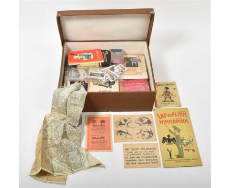
Mostly Dutch, but also incl. a few (pro) German items, ca. 1938-45. A varied collection, also including a number of items produced just after the war. A number of items have a caricatural nature, the collection also includes some modern reference works on this kind of art produced during the war. Incl. a.o.: (1) "Zeer geachte heer Schreuder. Indien mogelijk zouden wij het zeer op prijs stellen indien de kinderen nog even aan de schoolvoeding konden deelnemen, daar wij in het geheel geen aardappelen hebben [signed]." Short letter in pen, dated 16-5-1945. (2) "Geachte heer, gaarne zou ik zien, dat één of meer van mijne kinderen in de komende tijd aan de warme schoolvoeding zouden kunnen deelnemen [signed]. Short letter in pen, dated Amsterdam, 14 mei 1945. (3) "Oorlogswinter 1944-1945." Large fold. plate after L. Visser, the sheet measuring 49.5 x 65.5 cm, publ. by Vondel in Amst., (1945). Caricature showing the difference between fat Germans and starving Dutch people. (4) English language folded silk soldier's map of France, no date. (5-6) Two variants of the game "zoek het 5de zwijn/ where is the 5th pig"; when folded correctly, creates a portrait of Hitler. (7) Passierschein. Der deutsche Soldat, der diesen Passierschein vorzeigt, benutzt ihn als Zeichen seines ehrlichen Willens, sich zu ergeben. Safe conduct. The German soldier who carries this safe conduct is using it as a sign of his genuine wish to give himself up. Sm. folded leaf printed on both sides, w. the printed signature of Dwight D. Eisenhower. Sm. defects. (8) Tentoonstelling van fotografische opnamen van Duitse concentratiekampen en verwoest Arnhem. N.pl., n.publ., n.d. (1945), 32 p., orig. stapled wr. A shocking documentary series of photographs. (9) Hoef, A. v.d. Mijn kamp. Gedichten uit het Concentratiekamp, Amersfoort. Groningen, Werkman, (1945), 32 p., orig. stapled wr. (10) 22 sm. photographs, 8 showing the destruction after the bombing of Rotterdam, 14 Mai 1940. Some duplicates. (total approx. 220 in 1 box)

Mostly consisting of richly ill. periodicals in var. languages, but also incl. tourist guides, propaganda booklets, etc. Comprises a.o.: (1) U.S.S.R. im Bau/ In Construction, 11 numbers 1931-49 (incl. numbers 2-4, 5, and 7-10 of year 1949). (2) Sowjetunion. Nr. 3, 6 (52), 95, 99-102, 104, 105 and 11 (404), 10 numbers 1950-83. -and 3 numbers of the French edition. (3) 1961. De USSR. Propaganda booklet, n.pl., n.publ., n.d., 48 p., finely designed w. num. ills. incl. photomontages and isotypes. (4) Leningrad town views. State Fine Arts Publishing House, Moscow, 1963, no pagination, text in English and Russian, richly ill., orig. cloth-backed boards w. (sl. torn) dust wr., obl. large 8vo. (5) UdSSR. Abteinung der UdSSR auf der Weltausstellung in Brussel, 1958. Fold. flyer, unfolded measuring 57.5 x 44.5 cm, w. map and ills. Sl. imperfections. (total approx. 40)

1933-1983 (for the 50th anniversary of the company). Paris, Raffy, 1983. 60 x 95 cm. (2) Massé, J. Air France world map. Paris, Perceval, ca. 1970. 146 x 84 cm. -and 3 others, incl. a reprint of Mitschké's 34 avions d'Air France poster. Edges sl. worn, world map w. sm. pinholes in corners, not affecting image. (total 5)

19th-20th cent. Comprises a.o.: (1) Natives. Their homes and customs (South Africa). N.pl., n.publ., n.d. (ca. 1900), 16 photogr. plates, orig. wr., obl. 8vo. Front wr. loose. Very rare photo album on the Zulus. (2) Van Nelle's Koffie. Van Nelle kwaliteit. Sm. poster, 26 x 19 cm, des. by Reclamebureu Publi, (1957). (3) Sudan. Sudan Railways. Itineraries of inclusive return tours. Summary of main services from 1st November, 1937. Fold. leporello printed on both sides, 14 p., w. photogr. ills. and a map, 8vo. (4) Odd Hølaas: Ook ik ben Amerika. Prospectus, Utrecht, Erven J. Bijleveld, (1938), bifolium w. photomontage front cover. (5) Een lustrum-pakket! 2 Romans voor 1 maal f 1.40! 2 Romans in 1 pakket! Advertorial booklet for the Nobel-Reeks (Nijkerk, Callenbach), 1939, 8 p., w. ills. and photomontage front cover, orig. stapled wr. Duplicates. (total approx. 100 in 2 binders)
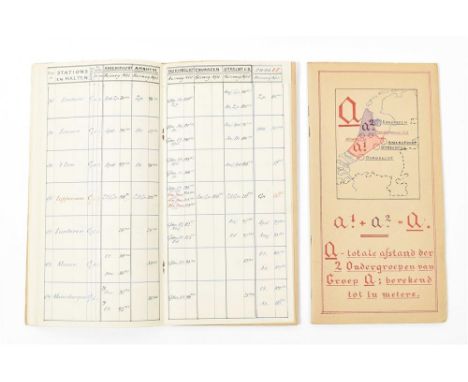
Ca. 1944. Hand dec. cardboard portfolio w. 3 loosely inserted pamphlets (for different regions of the Netherlands) of color-coded manuscript train schedules, each pamphlet w. (fold.) map(s) and schedules. Portfolio 28.5 x 15 cm. Covers sl. stained, some browning. Incredibly detailed and beautifully crafted manuscript train schedule.
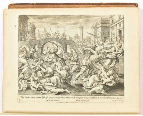
Even als de zelve in het H. Schrift bevonden worden met nutte en wyd-loopige Aenmerkingen verrykt ende opgeluystert door twee-honderd uytmuntende Print-verbeldingen zeer konstiglyk in 't Koper gesneden door Joannes; Philippus, en Theodorus Gallée. Antwerp, C.M. Spanoghe, 1783. 1 (of 2) vols. (8),XXIV,284,(12) p. Richly ill. w. engr. frontisp. (sm. tear), 170 full-p. engr. plates and 6 p. w. 4 sm. engr., numb. 1-24, mainly after M. de Vos and M. Heemskerck. Contemp. (worn) marbled calf (front cover almost detached), gilt title and dec. on ribbed spine. 4to. Lacking large fold. engr. map of the Holy Land, 6 plates (normally, the work lacks more plates). Rare, almost complete, Antwerp Print bible.

behelzende in het kort voor de jeugd alle de voornaamst merkwaardigheden onzes Vaderlands (...) met platen. Dordrecht, Blussé en van Braam, 1830. xxxvi,311 p. Incl. fold. handcol. map. Paper binding on spine worn. Added: Muller, J.F.L. Alphabetisch Letterkransje. Amst., D. Noothoven van Goor, ca. 1850. Fine copy on thick paper. -and 4 more 19th cent. Dutch alphabet books. (total 6)
der Zeven Vereenigde Provincien. In 't Nederduits overgeset d. H. v. R(ijn). Leiden, D. Haak, S. Luchtmans & J.A. Langerak, 1726. 6 vols. 1 large fold. engr. map of Zeeland (repaired tear), 6 fold. bird's eye plans of cities in Zeeland, 1 bird's eye view of Utrecht, 28 (fold.) views/ plates (2 extra), 24 (mostly fold.) portraits (1 w. 2 sm. tears, sl. affecting image), num. in-text ills., portraits and coats of arms. Unif. contemp. vellum w. blindst. centerpiece, manuscript title on ribbed spine. Folio. 1 vol. w. library ticket on spine. Some stains/ defects on covers, a few parts very browned/ foxed. (total 6)

Leiden, F. Hackes & P. Leffen, 1658. (16),317,(11) p. (addendum of 4 p. added after p. 14) engr. title-p. vignette (coat of arms of the city), later imitation leather, 4to. (2) Leiden. Leiden, Gebrs. Snel, n.d. (ca. 1910). Leporello, w. 12 photogr. in sepia, orig. dec. cloth, 8vo. Most leaves loose. (3) Vries, J.H. de. Uitbreiding van Leiden's grondgebied. Leiden, A.H. Adriani, 1889. 18 p. orig. paper wr. (4) Leiden en Omstreken, Gids voor vreemdelingen bij een bezoek aan de stad en hare omgeving. Leiden, L. van Nifterik, n.d. (ca. 1910). Orig. printed paper wr. w. map on back, w. fold. city plan and fold. table. Stamp on wr. and sl. soiled. All in good condition (total 4)

(1) Historische, geographische, Konst- en- reis Almanach voor den Jaare 1770 (...). Amst., Steven van Esveldt. Engr. title-p., fold. map of the Middle East handcol. in outline, 12 engr. plates for the months. Later speckled paper wr. Provenance written on upper flyleaf. Good copy. (2) Almanak, van vernuft en smaak voor het jaar MDCCXCVIII/ MDCCCI. Ibid., Wed. J. Doll. Contemp. (worn) gilt calf. Provenance written on upper flylvs. Upper covers detached. (3) Three Enkhuizer Almanaks, 1827/ 1835/ 1845. All w. title-p. woodcuts, sm. woodcuts for the months. (Worn) wrs. (4) Two Nederlandsche Muzen-Almanaks, 1832/ 1837. Both w. engr. frontisp. portraits and engr. title-p. 1 w. upper cover detached. -and 2 others. All w. signs of wear. (total 10)


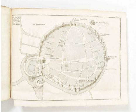
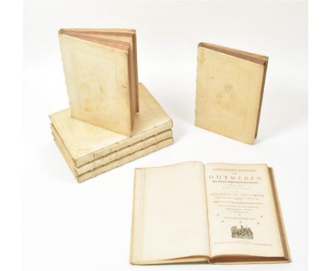
Behelzende de oudheid van het graafschap Stryen (...) mitsgaders de opkomst en eerste beginselen der stadt Breda (...) alsmede een nauwkeurige en beknopte beschryving van het landt van Breda door Thomas Ernst van Goor. The Hague, Jacobus vanden Kieboom, 1744. Sm. folio, calf, blindstamped, title on spine in manuscript, title page in red and black, dedication with coat of arms of the sponsor, 1 folding engraved map, 7 folding engraved plans, 15 other engravings (incl. the spendid folded view of Breda) and 27 engraved ills. in the text, all by B.F. Immink, some after P. de Swart, and 3 folding genealogical tables, XXVIII,545,[1] pp., binding with light traces of use, else in very good condition. First edition of this history and description of the city of Breda.

's-Gravenhage, J. v.d. Kieboom, 1744. xxviii,545,(1) p. Complete w. dedicatory cartouche w. arms, 1 large fold. map, 3 fold. plans, 15 (fold./ double-p.) engr. plates/ views, num. in-text engr. of seals, coins and arms, 3 double-p. genealogical tables. Hcalf w. speckled paper boards. Sm. folio. Covers sl. worn, some fold. plans/ views w. sm. tears, especially along folds, occas. foxing.

Twintigste/ Een en Twintigste Deel (...). Amst. etc., J. de Groot et all, 1793-94. 2 vols. (4),538,(26); (4),446,(18) p. Complete w. engr. frontisp., 1 fold. map, 7 fold./ full-p. engr. plates. Unif. (sl. worn) hcalf w. speckled paper boards, gilt dec. and mor. letterp. on spine. 8vo. Very good set. (total 2)
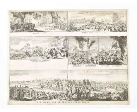
on a double leaf (43 x 55 cm) with below Üyt-Tocht van de Fransen uyt de Graef and 5 other engr. Depicting attacks by the French along the Maas river near Grave, Vellep and Moock. Strengthened w. Japanese paper. Rare. (2) De Stadt Graef. View along the river Maas, copper engr. glued on paper w. title, coats of arms and legenda, 20.5 x 36 cm. (3) Manuscript map in ink of Eschharen s.e. of Grave, 30 x 35 cm. A few tears. (total 13)

Contenant Une déscription éxacte du Païs, des Moeurs & des Coutumes des Habitans (...). The Hague, la Veuve de Meyndert Uytwerf, 1710. 2 parts in 1 vol. (14),416; (6),503 p. Complete w. 2 engr. frontisp., 2 title-p. vignettes, 2 fold. engr. maps, 20 fold. engr. plans and 5 fold. engr. views. Contemp. calf. Sm. 8vo. Library annotations in pencil upper flylvs. Covers and spine worn, foxing/ browning as usual, 1 map w. large tear.
Dorp en kerspel/ De Waterschappen. Utrecht, Kemink, 1963. Vols. 1-2. Sc. 4to. (2) Mijnssen-Dutilh, M. Amersfoort lag aan zee & Een vallei vol water. Waterschapskroniek Vallei & Eem. 777-1616/ 1616-2011. Utrecht, Leudsen, 2007-11. Vols. 1-2 and loose insert w. map for vol. 2. Hcl. (2 vols.). 4to. (3) Gelre-Geldern-Gelderland. Geschiedenis en cultuur van het hertogdom Gelre. Geldern, Historischen Vereins für Geldern und Umgegend, 2001. 527 p. Hc. 4to. -and 3 other works about Gelre and Gelderland. -and 5 others. (total 14)

das ist Beschreibung und Abbildung der fürnembsten Örter in den Niderländischen XVII Provincien. Frankfurt, C. Merian, (1659). 283,(20) p. Allegorical engr. title-p., num. copper engr. w. fortifications, 1 general map, 11 maps of the provinces, 22 double-p. lvs. w. 2 views eaach, 3 full-p. engr. views and 6 large fold. views, among them of Amsterdam and Rotterdam. Leather. Sm. folio. Waterst., a few brown spots, one view w. tear, otherwise a good copy w. most maps and views present.

(1) Optical view Berlin. Prospectus Armamentarii regii versus arcem Principis Regis haereditaru Berolina. Augsburg, G.B. Probst, ca. 1760. 31 x 44 cm. Col., captions in Latin, Italian, Dutch and German. (2) Some steel engr. views along the Rhine. (3) Some steel engr. Swiss views. (4) A few smaller maps incl. a.o. Wallischer Land in Switserland by Seb. Münster, ca. 1580; Dietmaerschen in Germany by Ortelius; 3 decorative col. maps by Van der Aa, ca. 1700; and a general map of Germany by Cluverius and Wolters, ca. 1700. -and 2 more copper engr. (total 32)

(1) Vue de Blackwall en regardant vers Greenwich. Col. copper engr. optical view by Basset, 25 x 40.5 cm. Paris, ca. 1780. (2-3) Vue de la Compagnie a déjeuner dans la Rotonde (...) Jardins de Renelagh a Londres. Huquier Fils. Paris. Col. copper engr. optical view, and the same uncol. (4) Vue interieure de la Bourse Royale a Londres. Daumont. Paris. -and a few steel engr. Together w. a map of the Dutch Fleet near Sheerness and Chatham, 1667 (22 x 30 cm), 2 maps of Ireland by Laurie & Whittle (1807) and C.F. Weiland (1827), 2 maps of Great Britain by P. Schenk after N. Visscher, col. in outline, lage folio and a col. map of Great Britain by I. Tirion, Amst., ca. 1750. (total 16)


London, L. Davis, 1772. 3rd English ed. 2 vols. (24),479; (4),419,(15) p. 1 fold. engr. map, 6 fold. engr. plates (some w. plans). Unif. calf, mor. letterp. on spines. 8vo. Ex libris "Capt. Donnelly" lower pastedowns. 1 plate torn (sm. part lacking), 1 plate torn along fold, 1 plate and map w. sellotape repairs along folds, some foxing. (total 2)
Dressée au Dépôt des Cartes et Plans de la Marine. By F.E. de Rosily-Mesros, 1798. 70 x 49 cm. W. title, coastline and profiles of the Vietnamese coastline. (2) Troisieme Feuille des côtes de Cochinchine depius le Cap Boxhornen justqu'au Cap Choumay (...). W. title, coastline and inset of the Vietnamese coastline between Cap Choumay and L'Ile des Tigres. These first 2 maps show the early days of French political interest in Vietnam. Both w. a few tears at the sides. (3) Nautical chart of a part of the Malabars by F. Valentyn. Dordrect, J. van Braam and G. Onder de Linden, 1724-26. 30 x 38 cm. Col. (4) Descrittione dell Isola di Taprobana. Early ed. of Porcacchi's very attractive and early map of Sri Lanka. Venice, G. Porro, ca. 1600. 11 x 15 cm. Restored. (5) Carte des déclinaisons et inclinaisons de L'Aiguille Aimantée (...) 1775. 51 x 58 cm. Paris, La Perousse; Buffon, 1788. -and 8 more maps (17th and 18th cent.) and prints of a.o. Isfahan and Samboupo on Celebes (Indonesia). (total 13)

(1) Carte de L'Océanie. Brussels, P. Vandermaelen, 1830. Map image 56 x 68 cm. Lithogr., col. in outline. (2) Australie. Paris, J. Migeon, ca. 1880. Map image 31 x 42 cm. Fully col. steel engr. w. uncol. bird's eye view of Sydney below. (3) Océanie. Idem. W. bird's eye view of Nouméa. -and 4 other maps/ print. (total 7)

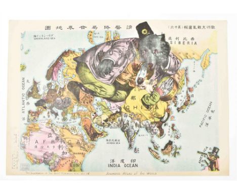
Satirical map of the First World War in Europe. Ryozo Tanaka. Tokyo, Shobido & Co., 1914. 39 x 55 cm. Text in both English and Japanese. Rare Serio-comic map showing the political relations during World War I, shortly after the Chinese Revolution, from the Japanese point of view. This map was designed and printed by Tanaka Ryozo (1874-1946), who ran a print shop in central Tokyo and later became well known for producing prints of works by prominent modern woodblock artists. Although it is described as 'map of the world', it is really a map of Europe, Asia and part of North Africa. The US is interestingly shown as a man in a top hat looking at Asia through a telescope from a small patch of land that appears to be somewhere in the middle of the Pacific. The rest of North and South America and all of Australia and New Zealand are missing. The colourful and decorative map cleverly depicts each country as an animal, or more rarely as a human figure, giving an intriguing insight into Japanese perceptions of the state of the world (and some Japanese prejudices about neighbouring countries!) at the start of World War I.


Col. lithogr., 40 x 52 cm. Amst., Senefelder, ca. 1914. This fascinating propaganda map was created by L. Raemaekers, a famous Dutch cartoonist, at the beginning of World War I. Early in the war Raemaekers crossed the border into Belgium to witness first-hand the brutality of the advancing Germans. The title of this map translates roughly as: "The Insane Asylum (Old Song, New Tune)" referring to Holland's perspective of the war waging around them. Although Holland is depicted sitting peacefully, smoking a pipe, he is holding a gun and keeps an ever-watchful eye on his neighbor. Folds as publ., sl. foxed, partly rep. tear along middle fold.
secondo le relationi piu moderne da Guglielmo Sansone Geografo di S.M. Christianissima. E data in luce da Gio. Giacomo de Rossi in Roma nella sua Stamperia alla pace l.Anno 1677. [The Rossi Europe map after Sanson]. 41 x 55 cm. Doubled w. japan paper, col., cartouche w. coat of arms, title, dedication and author. (2) L'Europe divisée en ses principaux Etats, par le Sr Robert de Vaugondy, fils de M. Robert Geographe ordinaire du Roy. 1751. 48 x 58 cm, col. in outline, cartouche w. title and author and table w. scales. Some notes outside the map image. (3) S. Imperium Romano-Germanicum oder Teutschland mit seinen angräntzenden Königreichen. Amst., N. Visscher, ca. 1680. 47 x 57 cm, col., title on top, coat of arms, scales. Some notes w. pencil. Restored. (total 3)

Classé pour chaque commune de l'arrondissement de Beaune suivant le mérite des produits. Par les soins du comité d'agriculture de l'arrondissement de Beaune. Et pour l'arrondissement de Dijon, par une société de viticulteurs. Col. lithogr. map after M.I. Bonnamas, on 3 attached sheets, together measuring 45.5 x 285 cm, Beaune, Batault-Morot, n.d. (ed. between 1861 and 1895), kept rolled in orig. wooden box w. printed label of Charles Bernard dated in pen "14 Setbre. 1895" and w. address in pen "Monsieur Charles Durieux Negt. (?) en vins à Marche (Belgique)" and annotation "carte des vignobles", the box (w. remnants of the orig wax seal and paper labels) measures 47.5 x 4.3 x 4.5 cm. The map rolled, and w. a few sm. tears and pinholes in blank margins, otherwise fine. Very rare separate edition of the map also published in the booklet Plan statistique des vignobles produisant les grands vins de Bourgogne (...), first published in Beaune in 1861. Not coincidentally, the booklet was published just before the great London world exhibition of 1862. The map is divided in areas w. different colours indicating the vineyards of the 1st, 2nd or 3rd classes. The mentioned areas are Santenay, Chassagne, Puligny, Meursault, Auxey, Monthélie, Volnay, Pommard, Beaune, Savigny, Pernand, Aloxe, Serrigny, Prissey, Premeaux, Nuits, Vosne, Flagey-les-Gilly and Vougeot. The very nice (and extremely rare) original wooden box was used to send this copy to wine dealer Charles Durieux in Marche, Belgium, in 1895. The winery Charles Bernard that sent the map, still exists.

(1-2) Netherlands. Northern part. Seb. Münster. 20 x 17 cm map image. 1x uncol. from a French ed. and 1x col. from an Italian ed, both ca. 1600. (3) Frisiae. J. Bussemacher. Cologne, Matth. Quad, ca. 1600. 18.5 x 27 cm, fully col. (4) Frise Occidentale. G. Mercator, ca. 1630. Oval shaped map, 12 x 18 cm. (5) La Frise. Pierre Vander Aa, ca. 1730. 26 x 38.5 cm, fully col. (6) Leaf from Braun & Hogenberg, ca. 1600. W. Lewardum and Franicher, fully col., fom a Latin ed., map images 31 x 29 and 31 x 19 cm. -and 3 other later maps. (total 9)

Auctore Joh. Westenberg. This folio map is from the rare Spanish edition of the Atlas Maior. 38 x 50 cm. signed in the map: Guljel. Blaeu. Large cartouche w. title and coats-of-arms. Original colouring. The town of Coevorden left below. (2) Gochum vernacule Goch. Folio plan and surroundings of Goch (next to the Dutch border at Siebengewalt. Limburg). Leaf from the "Stedenboek" by Blaeu. Amsterdam. 1649. Verso Latin text. 15 more smaller maps from the same region. (total 17)


Wall map, 90 x 120 cm. Folded w. tears and wrinkles, the lower right corner w. some loss of text, the side panels w. buildings and the lower panel w. a view on the city are missing. The upper panels w. the coats of arms of the city and the mayors accounted for plus some duplicate title and coats-of-arms panels. Added: Another issue of the same town plan in 4 parts, 48 x 60 cm each. W. scales, numb. street plan and town council, the upper left corner w. another cartouche w. a patent by the "Staten van Holland ende West-vriesland" for this map. The lower left part w. huge printer's error. Some extra duplicates from another identical maps incl. Both maps sold w.a.f., not subject to return. (total 2)

Hollandia. Antwerp, A. Ortelius, ca. 1570. Fully col., coat of arms, windrose, scales, Latin text verso. Sturdy paper. Ref. Koeman-Krogt 3400:31: 001 or 002. (2) Belgii Veteris Typus. Ibid. idem, ca. 1601-12. Historical map, cartouches w. title, dedication, poem, year, etc., Latin text verso. Paper sl. browned, repaired tear upper left outside map image. Ref. Koeman-Krogt 3000H:31B. ed. between 1601-1612 Vol. IIIB. p. 770. (total 2)

Nauclerorum domicilium. Copper engr. w. old colouring, decorative town plan in bird's eye view w. title from a Latin ed., ca. 1600. Sl. browned, a few minor tears outside the map image. (2) Harderwijk. Herderwijck. Copper engr. w. old colouring, 2 views on one sheet w. title and coat of arms, verso Latin text, ca. 1600. Sl. browned, minor faults. (3) Enkhuizen. Die Stadt Enchuijsen. Col. copper engr. in bird's eye view w. title, legenda and coat of arms, ca. 1600. Under passepartout. (4) Bergen op Zoom. Berga, ad Somam, Brabantiae Opp: a fluvi olo sic dicto (...). Col. copper engr., ca. 1600. Under passepartout. Dam. (total 4)

(...) Balthazar Floris van Berckenrode. Amst., H. Hondius, 1629. Col. copper engr. w. folds, 46 x 56 cm. Note on left margin. (2) Hollandiae pars septentrionalis vulgo Westvriesland en 't Noorder Quartier. Amst., W. and J. Blaeu, ca. 1660. Cartouche w. putti, coat of arms and title, text verso, German ed., 39 x 50 cm. Borders reinforced. (3) Noordt Hollandt. Amst., F. de Wit, ca. 1700. Col. copper engr., 45 x 55 cm. Sl. dam. (4) Col. polder map. Amst., H. Hondius, ca. 1630. W. Zype, Beemster, Purmer, Wormer and detailed inset of Waterland, verso Latin text, folio leaf. (5) Detailed folio map "The Y" and surroundings, w. a.o. the sm. islands of Den Hem, Den Hoorn and Ruigoord. 18th cent. -and 1 other. Sold as a collection of maps w.a.f. (total 6)

One section only (east of the line Groningen-Assen and south of Harkstede-Buitenpost) of the large J.H. Jappé map in four sections. Groningen, J. Oomkens, 1835. Lithogr. after an engr. by J.C. van Baarsel, 60 x 83 cm, detailed map of a part of Groningen w. title, coat of arms and scales. Minor flaws and a repaired tear.

op de schaal van 1/ 200.000. Vervaardigd naar de Groote Topographische Kaart van het Ministerie van Oorlog. Onder toezigt van de H.H.E. Olivier Dz. en P.H. Witkamp. Lithogr. map w. handcol. outlines on 6 loose sheets, each measuring 64 x 77.5 cm. The Hague, J. Smulders & Cie for C.L. Brinkman in Amst., 1878. Sl. foxed, vaguely folded and sm. imperfections in (wide) blank margins. A good copy. (total 1 map on 6 sheets)

en Brumaire an 3 (8bre et 9bre 1794)'. Exceptionally detailed hand-col. map of the invasion of Nijmegen in 1794. 71 x 90 cm. Folded, but in fine condition. Legenda: 'Plan de l'investisement et attaque de Nimegue par l'Armée Francaises. Nota l'Investissement sur la Rive Tauche du Waal à En lieu le 6 Brumaire, An 3me. de la République francaise (27 Octobre 1794 d.s.) l'ouverture de la tranchée n'a Ete faite que la Nuit du 11. au 12. Brumaire (1 au 2 8bre) Et la Garnison s'est rendue prisonniere de Guerre Le 18 Brumaire An 3 (8 Novembre 1794).


gelegen in acht gemeenten, met de verdeeling der sectien volgens de kadastrale plans, opgemaakt in den jare 1836 op verzoek van Heeren Dijkgraaf en Heemraden van de Schermeer. Door den Landmeter A. van Diggelen. Engr. by Veelwaard and Son. Large wall map in 12 segments on (sl. torn) linen, together measuring 81 x 103 cm. Large cartouche w. title and the coats of arms of the members of the board of the "Schermeer": Dijkgraaf P. de Sonnaville, and Heemraden, D.C. De Dieu Fontein Verschuer, J. Vader, J. van Leeuwen, A. Konijn, J.C. van de Blocquery, L. de Sonnaville penningmeester, J.Helling, A.P. de Lange secretaris. The Hague, Kunstplaatdrukkery van de Wed. A. Koning en J.F. Brugman. Added: An identical map without the cartouche over the title (taken out and replaced by blank paper), Haarlem, Joh. Enschede & Son, ca. 1836. (total 2)
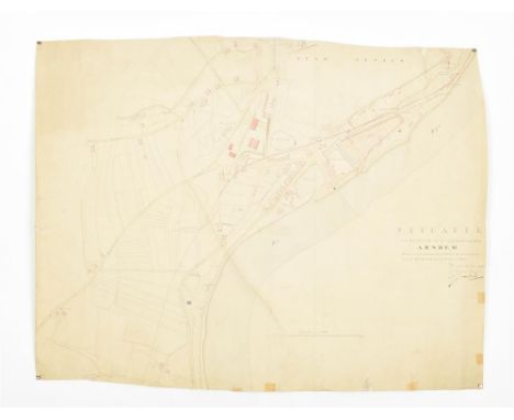
Manuscript handcol. map, fold. leaf of 60 x 77 cm, depicting 'Situatie van het terrein in de nabyheid der Stad Arnhem Waarop is aangewezen het ontwerp tot verbinding van den Ryn Spoorweg met de Rivier de Ryn', signed by the engineer director Utrecht, 1846. Some tears with a number of repairs and strengthening with tape. (2) Manuscript handcol. map "Arnhemsche Brock. Undated, but most probably also 1846. 46 x 66 cm. (3) Manuscript map 'De Stad Arnhem'. Same series. Irregularly shaped, Some repairs and strengthening with tape. 59 x 83.5 cm. (total 3)
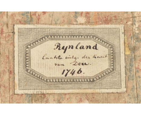
((...) vernieuwd, geamplieerd en gecorrigeerd (d. M. Bolstra)). (Amst., I. Tirion, 1746). Double-p. engr. title, 12 double-p. engr. maps (together forming a wall map of approx. 186 x 168 cm) and 1 double-p. engr. w. projected sluices near Katwijk, all (except engr. title) in fine cont. col. Cont. half goatskin. Large fol. Spine partly dam., binding rubbed/ chafed, without the extra map of the Haarlemmermeer, which is normally added to this edition, otherwise in good, clean and uncut condition. Third, corrected edition of this fine, coloured and detailed polder atlas of Rijnland in outstanding condition. The maps were engraved by David Coster after Melchior Bolstra's revision and augmentation of the second edition of 1687/88. The last plate represents the 'Concept sluijzen 1629' (representation of the sluices) near Katwijk. Donkersloot-De Vrij, 715 mentions the name of the publisher who can not be found on the maps themselves. She also states that the edition was limited to 650 copies only. Koeman, Geschiedenis van de Kartografie van Nederland, p. 138.

Contemp. handcol. engr. wall map on 17 loose sheets (incl. coats of arms) by J. Leupenius and D. Coster, 1818. Together measuring approx. 144 x 205 cm, mounted on linen. Rare map, first published in 1683 and republished with alterations between 1696 and 1818, usually in small editions of about 200 copies, sometimes published bound together as a book. The editions varied predominantly in the coats of arms of the changing dike reeves but also in some editing of the map itself. (Ref. Donkersloot-de Vrij 766).

Met toepasselijke versjes. Naar het Hoogduitsch van Gustaaf Holting. Derde druk. Middelburg, Gebr. Abrahams, n.d. (ca. 1860), 12 lvs. printed on 1 side only (incl. title), each w. handcol. lithogr. ill., orig. (sl. worn) printed wr., sm. 8vo. (2-4). De lente. De zomer. De winter. Naar het Engelsch. Groningen, W. van Boekeren, 1840/ 1846/ 1839, 3 vols., each w. 5 plates, orig. printed boards, sm. 8vo. W. a few owner's entries, Zomer a bit browned, Winter sl. shabby/ worn. (5) Krummacher, F.A. Het duifje. Uit het Hoogduitsch. (Met vijf plaatjes Steendruk.) Ten voordele van het Zieken- en Schoolhuis te Dusselthal. Amst., A.B. Saakes, 1827, 43,(1) p., 5 lithogr. plates, contemp. marbled paper wr. 3 plates handcol. in a child's hand. An early Dutch example of the use of lithography in a book. -and 7 nicely ill. others, first half 19th cent. (1x ca. 1850), incl. a description of Arnhem w. large fold. map (1832). (total 12)

met het noorden en westen van de Vereenigde Staten van Amerika door W.R. Morely & Corns. de Groot. The Hague, L & H van Langenhuysen, n.d. (late 19th cent.). Lithogr., 76.5 x 37.5 cm. Map showing the proposed Two Butte and Cimarron Railroad line in present-day New Mexico in the United States. Folds, some sm. holes, sl. affecting image. Rare.

(...) doen meten, en in kaart brengen, door Bernard du Roy (...)." Engr. wall map on 10 double-p. (missing 11 p. w. 5 sm. maps, forming the bottom row) sheets by B. de Roij, loose sheets, w. watermark of coat of arms, w. large cartouche, without border dec., engr. by T. Doesburgh after G. Hoet, each sheet 63 x 53, engr. 56 x 38 cm, Amst., N. Visscher, (1696-1702). Of the until recently unknown 2nd ed. (of 5), which added city plans a.o. changes. Only other copy of this ed. at Rijksmuseum. Fine and clean copy. Very rare map, the most authoritative of the province of Utrecht during the 18th and the first half of the 19th century.

N. Visscher. Amst., P. Schenk Jr., ca. 1700. This map is joined from 2 plates (47 x 85 cm) and is a re-issue by Schenk after Visscher, both mentioned in the large title cartouche w. putti and coat of arms on top centre. Engr. by L. van Anse, orig. col. Sm. right margin. (2) La Seigneurie d'Utrecht. N. Sanson. Paris, H. Jaillot, 1696. 43 x 56 cm, col. and partly heightened in gold (towns and cartouches), the 2 cartouches w. title and scales, verso blank. Affected by oxidation w. repair. (total 2)

31 x 46 cm. Chromolithogr. Folded, tear in bottom left corner, outside the map image. (2) The same but a different title: Welt-karte der Mission. Litho Walter & Engelmann pere et fils, Mulhouse, France. Basel in der evangelischen Missions-Anstalt. 30 x 45.5 cm. Lithogr. Plano. (3) The same, one color (blue) lithogr. on sturdy paper. Plano. (4) Mc. Cormick's Map of the World. 1930. Folded sheet, col. 40 x 45 cm, double hemispheric map w. flags below. Verso w. promotional text w. sailing ship and globe. (total 4)

1812. Gravé par Semen. Lale Scrip. Vuillemin. Paris. Fold as publ. (2) New Granada, Venezuela, Guiana; Peru. Equasor; Argentine Confederatio. All on 1 col. map. Pennsylvania, S.A. Mitchell Jr., 1860. (3) 32 maps by John Tallis & Company, London/ New York, ca. 1850. Ill. and mostly col. from var. ed. (4) 33 maps by Smith and A. Bixet. Paris, J. Mignon, 1880. All w. sm. ills. and col. maps. (total 67)

10 folio lvs. from Accuratissima Orbis Antiqui Del. Sive Geographica Vetus Sacra. Amst., J. Janssonius, 1653. Reissue after the historical atlas by A. Ortelius in his Parergon, The F. Hornius historical atlas w. maps by a.o. Kaerius and Duval. (1) Geographia Sacra. Col. map of the ancient biblical world showing Europe, the Mediterranean, northern Africa and Asia Minor w. 2 cartouches and a sm. world map. 36.5 x 49 cm. (2) Lumen Historiarum per Occidentem et conatibus Fran Haraei and P. Kaerius. (3) Itala nam tellus Graecia Maior [South Italy] by J. Janssonius w. large cartouche. (4) Africae Propriae Tabula w. large title cartouche and cartouche below w. Plinius notes, a.o. (5) Thraciae Veteris Typus w. 3 cart. w. title and expl. by P. Kaerius after A. Ortelius. (N. Greece). (6) Vetus Descr. Daciarum nec non Moesiarum [Romania and Bulgaria] by P. Kaerius. (7) Pontus Euxinus [Black sea w. Crimea] by P. Kaerius after A. Ortelius. (8) Aegyptus Antiqua by P. Duval. (9) Insular Aliquot Aegaei Maris Antiqua Descrip. A. Ortelius. Antwerp. W. 10 groups of maps on one sheet. (e.g. Sardinia, Corsica, Euboea a.o) taken from another similar Janssonius historical atlas. Sl. browned and waterst. along the edges. (10) Italia Gallica sive Gallia Cisalpina. P. Kaerius after A. Ortelius [N. Italy]. Nice but incomplete folio set. (total 10)
-
108737 item(s)/page