We found 109198 price guide item(s) matching your search
There are 109198 lots that match your search criteria. Subscribe now to get instant access to the full price guide service.
Click here to subscribe- List
- Grid
-
109198 item(s)/page


Lot 253
Marble Map Coffee Table New York An engaging, limited edition piece, representing some of the world’s most iconic cities to prompt discussion, inspire travel or evoke memories. Map drawings are translated onto the marble which is laser-cut and inlaid with brass, then polished to achieve a smooth, flush surface. Each piece requires absolute precision and takes many hours to create.An elegant and refined coffee table to spark a conversation, infusing and activating the senses with rich, contrasting materials and plenty of drama. 120 x 120 x 38 cm 150kg RRP £10825

Lot 418
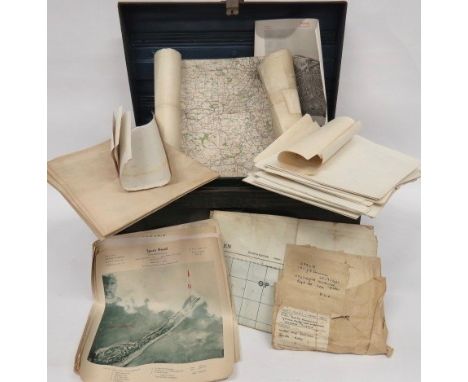
WW2 German Maps and Target Maps of Various British Cities varied selection of maps including 12 x Blatt 14 coloured paper map of Lincoln... Various target maps and printed photo of Hull including the docks... Map showing Sheffield Power Station... Maps of Nottingham Gas Works... Small selection of various maps... 2 x 1972, 30 mm shells and dummy heads. All contained in a green painted tin trunk.

![[MAPS]. Senex, John (1678-1740). 'The Road from Exeter to Barnstable', engraved ribbon map, hand-coloured, 16cm x 23cm, fram](https://cdn.globalauctionplatform.com/1671b6e3-48bb-41c7-9a0b-a9d200fb622d/c365e16d-29ef-4c3f-9a02-a9e700dcb393/468x382.jpg)
![[HISTORY]. MILITARY Arnot, B. Douglas. That White Horse. A Brief History [of] the 629 (9th) Field Squadron Royal Engineers,](https://cdn.globalauctionplatform.com/1671b6e3-48bb-41c7-9a0b-a9d200fb622d/cd7a2bbc-a377-46a6-9802-a9e700dc7463/468x382.jpg)
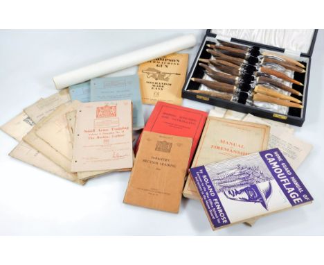
Lot 357
[HISTORY]. MILITARY Arnot, B. Douglas. That White Horse. A Brief History [of] the 629 (9th) Field Squadron Royal Engineers, first edition, Gale & Polden, Aldershot, 1947, dark blue cloth, illustrations, octavo; Brown, Rev. Frederick. From Tientsin to Peking with the Allied Forces, Kelly, London, 1902, pictorial ochre cloth, portrait frontispiece, illustrations, two-page publisher's list, octavo; and five other items, including a folding Daily Mail Bird's-Eye Map of the [Great War] British Front, Section 1, (7).


Lot 541
A selection of early 20th Century Survey maps of India to include a selection of railway maps, road maps and region maps all heliozincographed at the Survey of India Offices in Calcutta. Most paper, some being canvas backed. The maps include Central India & Central Provinces 1922, Mysore 1916, Road map of India 1926, Bengal & Eastern States 1937, Kashmir & Jamu 7 Punjab 1915, Bengal & North Western and Rohilkund & Kumaon Railways. 12 in total.
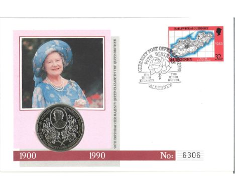
Lot 336
HM Queen Elizabeth The Queen Mother 90th Birthday official coin FDC PNC. Contains a 1990 £2 crown coin, struck by the Royal Mint in cupro-nickel to give the finest quality finish, it features a delightful cameo portrait of Her Majesty surrounded by pearls. Alderney's 1989 32p definitive issue stamp, showing a wartime map of the island. Guernsey Post Office 90th Birthday Alderney 4th August 1990 postmark. Good condition

Lot 403
CHURCHMANS, odds, inc. Army Badges of Rank, Association Footballers, Boxing, Boy Scouts, Frisky, Phil May Sketches, Sectional Cycling Map, 3 Jovial Golfers, Well-Known Ties, World Animals of the World; large, Holidays in Britain, Eastern Proverbs, Italian Art, Warriors of All Nations etc., in modern album, VG to EX, 250*

Lot 422
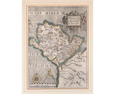
Five various maps including a Robert Morden hand-coloured map of Bedfordshire, an antique copper map re-engraved by Francis Grose of Dorsetshire, a black and white map of Hampshire and a colour map of Sussex 'By Ric Blome By His Ma Especall Comand' and a hand-coloured map of Dorset divided into its hundreds by Eman Bowen (5)
Lot 293
PRINTS AND EPHEMERA. AN ALBUM OF 18TH AND 19TH CENTURY ENGRAVINGS AFTER OLD MASTERS topographical, portraits, Theatre Royal playbill t'his Evening Thursday August 23 1821', folio with watercolour title page of woodland, en grisaille, inscribed Ann Oates Collection of Pictures in Two Volumes, marbled boards detached and miscellaneous other items including five miniature feather pictures of birds, 19th century visiting cards, three parchment deeds 1694 (Felsted, Essex) and 1822 and 1831 (Atherstone, Warwickshire), a late 18th c ms "Evening Amusements The Book of Fortune", 8p of lists, eg What are the Symptons of Love?, inscribed Miss Sarah Dawber, Daniel Dawber Esq, Blyborough [Lincolnshire] original blue paper covered wrappers, 18.5 x 12cm, Joseph Noble, Gazetteer of Lincolnshire ... folding map (torn), Hull 1833, John Cary, A New Map of Nottinghamshire, engraving in fresh contemporary colour, marbled boards with title label, backed on linen, marbled sleeve, 1824, etc++Many items in good condition, condition reports on specific part of the lot available on request


Lot 455
A collection of pictures and prints to include an RS Trade Press map of Ashby-de-la-Zouch Canal, a 19th century watercolour of a country lane, a woodblock print of a European city in the 16th century style, a print after Christoph Plantain, a book print of Pembroke castle and two small naive oil paintings, one a still life with flowers, the other of a lakeside castle, signed Rufus (7).
Lot 89
Early photographic interest, an interesting and varied collection of 8cm glass plate photographic slides, mostly representing travels to the African continent and Asia, to include; views of sharks being landed from a cruise liner, other scenes of fishing, portrait photography of the visitors and local population, a map detailing Dominica, scenes of everyday life, to include; domestic scenarios and tribal gatherings, one detailing Meke at Nikelo war dance of Fiji etc, together with other photographic and hand painted/coloured slides of novelty and humerous cartoon scenes etc, contained within two stained pine cases, one with internal label reading 'Herbert Bell Photographer Ambleside' (122 approx in total)


Lot 105
EDWARD BAINES, HISTORY OF THE COUNTY PALATINE AND DUCHY OF LANCASTER, PUBLISHED BY FISHER, SON & CO., 1836, bound in period half-leather binding, spines text states 'History of Lancashire', solid binding with some slight loosening to the boards on a couple of occasions, but holding; various maps and engravings throughout, some folding plates, with a large folding map of Salford and its environs, some tape repairs; a good set and an authoritative study of Lancashire


Lot 5
Kelly, Christopher "New and Complete System of Universal Geography ... of the Whole World and its Inhabitants ... Asia, Africa, America and Europe ... New Discoveries ...", printed for Thomas Kelly, London 1827, frontis folding map, various plates, plans, etc, foxed, full leather, gilt titles but all rather bumped and worn Gilfillan, Rev George"The National Burns including all the Airs of the songs and an original life", William McKenzie, illustrated plates, hinges cracked, pictorial cloth, in 3 vols (4)


Lot 88
Album of black and white and sepia photographs of India 1931-34, including photographs of the first tornado recorded in India, RAF station Peshawar, North West Frontier Provence, a 1937 geographia cloth folding map of India and album of black and white sepia photographs of Iraq 1929-31, including monuments, people and ruins The albums measure 26 x 25 cms each page. There are 103 photos in the Iraq album and 93 in the other. The size of the pictures varies between 14x9cm and 8.7 and 6x4cm. Please ring 01242 256363 if more detail needed
Lot 57
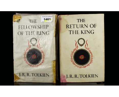
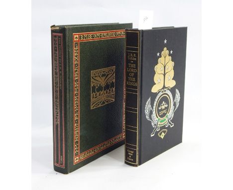
Tolkien J.R.R."The Hobbit or There and Back Again", illustrated by the author, Hughton Mifflin Company Boston 1966, first printing collectors edition, colour and other plates, green ep, green marbled edges, full green leather with gilt titles and decorations, within original leather covered slip case with pastedown titlesTolkien, J R R"The Lord of the Rings", George Allen & Unwin 1969, India paper edition, folding map, green speckled edges, marbled ep, black cloth with elaborate gilt decoration to front board and gilt titles, within original slip case (2)


Lot 342
John Henry Le Keux (1812-1896) engraving, 'St Mary's Church, Wareham, Dorset', 13.5 cm x 26 cm, framed and glazed. Together with William Taylor (act. 1825-1852) after Thomas Allom (1804-1872) coloured engraving, 'Chillingham Park and Castle, Northumberland', 9.3 cm x 15 cm, framed and glazed; and Thomas Moule (1784-1851) map of Hampshire, 20.5 cm x 26.5 cm, framed and glazed (3)


Lot 760
A Chinese carved camphorwood box and contents, including Mauchlin-type paper-knife printed with a world map on the blade and 1893 calendar on the handle - a complimentary gift from The Eastern Telegraph Company Ltd, cased pair of Ultraview 8 x 30 binoculars, a 1936 Air Ministry leather-covered 50ft tape measure by Chesterman, chrome perpetual calendar etc


Lot 554
Richard Blome (1641-1705) - Coloured engraving - "A Mapp of Kent with its Lathes and Hundreds", 7.25ins x 9.5ins; Herman Moll (1654-1732) - Engraving - Map of Kent, 8.5ins x 12.25ins, together with five Kent maps and small collection of coloured maps and descriptions from "The Illustrated Atlas and Modern History of the World", edited by R. Montgomery Martin, various (all unframed)

-
109198 item(s)/page