We found 109182 price guide item(s) matching your search
There are 109182 lots that match your search criteria. Subscribe now to get instant access to the full price guide service.
Click here to subscribe- List
- Grid
-
109182 item(s)/page


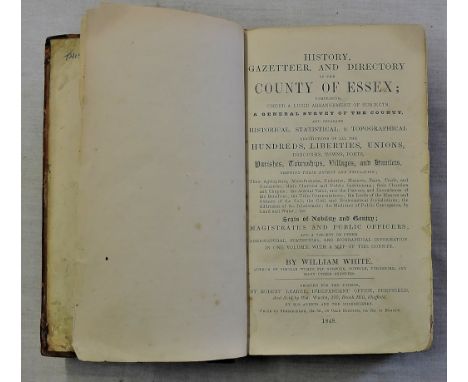
Lot 868
History, Gazetteer, and Directory of the County of Essex-White, William - Published Robert Leader, Sheffield(1848)-First Edition, 725pp+adverts, no map, brown leather hardback with gilt lettering, some staining and scuffing, book condition binding secure, good condition for its age, discolouration on ends of pages.
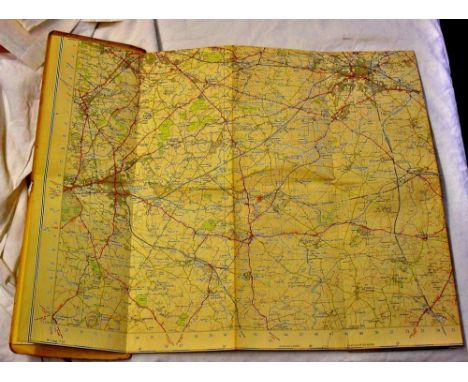
Lot 347
Environs of London - A Survey of the Country around London - To the distance of thirty two miles from St Paul's. Published by Rd H.Laurie No.53 Fleet Street London 1851, an improved edition to the original Survey of London.Engraved by Max Findlay. Set on 18 panels mounted onto canvas, condition good for age. Along with Second Edition Ordnance Survey map, Pair of Bartholomews Revised 'Half-inch' maps, two others and a Geographers London Atlas.


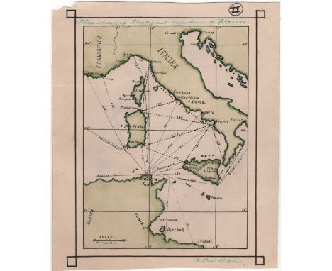
Lot 191
RITCHIE HENRY PEEL: (1876-1958) Scottish Royal Navy Captain, Victoria Cross winner for his actions at Dar-es-Salaam in November 1914. Ritchie received the first Victoria Cross awarded to Navy personnel in World War I. A good original colour pen and ink cartographic drawing signed ('H. Peel Ritchie'), one page, slim 8vo, n.p., n.d. (c.1893). The map drawn, in black, green and pale green inks, depicting southern Italy, Sardinia, Sicily, and the northern coast of Tunisia, with shipping routes and distances, entitled, 'Plan showing strategical importance of "Biserta"', in Ritchie's hand and signed by Ritchie at the base. The Roman numeral II has been written within a circle to top right edge. Light signs of former mounting to verso, and a slight tear to the top left edge. VGBizerte (also known in English as Bizerta), a town of Bizerte Governorate in Tunisia and the northernmost city in Africa.
![[SUMPTER LEONARD]:(1911-1993) British Royal Air Force Flight Sergeant, a member of 617 Squadron who participated in Operation](https://cdn.globalauctionplatform.com/20a823bd-ed1f-405b-a860-a79301069063/05110ee7-69d9-4c3b-eedb-c33ab5be4fd4/468x382.jpg)
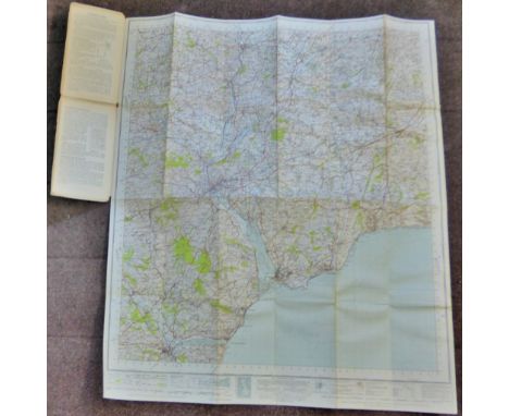
Lot 315
[SUMPTER LEONARD]:(1911-1993) British Royal Air Force Flight Sergeant, a member of 617 Squadron who participated in Operation Chastise (The Dambusters Raid) as Bomb aimer of Lancaster ED929/G AJ-L, 16th-17th May 1943. Sumpter's folding maps of Europe - Code AF Foldex No. 1. Europe (Air) 1/500,000, Directorate of Military Service, War Office, March 1945.Three large folding maps of Europe, double sided, and varnished so that 'courses can be marked in chinagraph pencil and subsequently erased with an ordinary rubber'. With various towns and cities within Holland and Germany circled in blue ink. Attached to 6 x 10½ hardback covers. With some minor tears to the vertical folds, water spots to the cover and age wear. Together with an unsigned 8½ x 11½ Navigators Log Book folder. The empty folder bearing various ink annotations to the inside cover, including telephone numbers and addresses, including that for his relative Lt. Kenneth Sumpter of South East Asia Command, with a document holder to the inside panel, with printed conversion charts for nautical miles, statute miles, kilometres, and metres/feet affixed. With a loose spine, light staining, bumped and frayed corners and age wear. Also including an unsigned 23 x 22 double sided silk escape map, the locations centring around Tbilisi, Georgia, to one side and Tabriz, Northern Iran, to the other. The map, with the word Restricted in red at the head and foot, detailing major towns and cities, railways etc. Published by the Geographical Section, General Staff, 1951, Fifth Edition. With Minor frays to the edges. G to VG, 3Provenance: Accompanied by a statement of provenance signed by Leonard Sumpter’s daughter attesting to the fact that the items included in the present lot were the personal property of her father.

Lot 214
Small selection of London Transport double-royal POSTERS from the 1960s/70s comprising 1968 'Get away on a Green Line', 1974 'London Transport Collection Gala Day', 1969 '140 Years of London's Transport' by William Fenton, 1969 Country Bus Services network map, 1965 Green Line Coaches by B G Lewis (1900-1966) & 1966 'New Green Line route 724 Express'. In reasonable to good condition with some scuffed edges, small edge-tears, filing holes near top. [6]
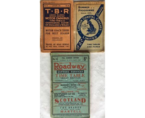
Lot 194
Selection of 1920s/30s Bus/Coach TIMETABLE BOOKLETS comprising January 1924 'TBR' (Travel by Road) Official Motor Omnibus & Charabanc Guide of England & Wales (tear to spine, fold-out map present but fold-tears), 1930 Summer Programme London Coastal Coaches 'ABC' Guide (good condition) and 1931 'Full Summer Edition' of 'The Roadway' Express Services Time Table for Great Britain (scuffed spine, otherwise good, pocket at rear is empty). [3]

Lot 277
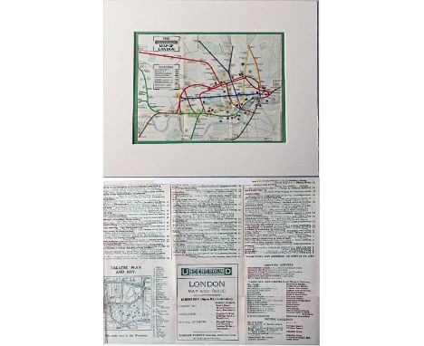
1934 London Underground diagrammatic, card POCKET MAP. An early H C Beck issue, No 2 1934, and showing the escalator connection between Bank and Monument stations. This is the version with 'Liverpool Street' close to the station symbol. An excellent example in very good condition, just a very small stain on the rear cover and a tiny nick at the bottom edge. [1]
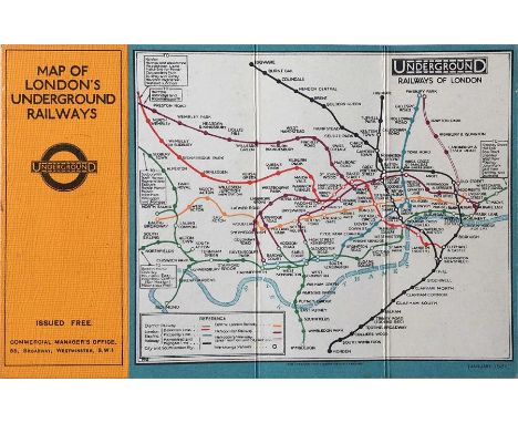
Lot 231
1922 London Underground MAP OF THE ELECTRIC RAILWAYS OF LONDON 'What to See & How to Travel' with issue date 1-3-22. Designed by MacDonald Gill with calligraphed station names, the map opens out to 13.5" x 11" (34 x 28cm). A very good copy with a very slight trace of adhesive on the spine where it was once tipped into a guidebook and a very small parting at one fold-corner but otherwise excellent. [1]

Lot 69
1923 London Underground MAP of the Electric Railways of London "What to see and how to travel". Designed by MacDonald Gill with his distinctive style of calligraphy and map border, this is the issue dated 1/11/23 which shows the British Empire Exhibition stations with red dots. In used condition with some annotations on the cover and foxing marks in places but a very reasonable copy still. [1]

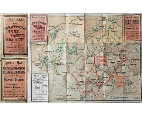
Lot 393
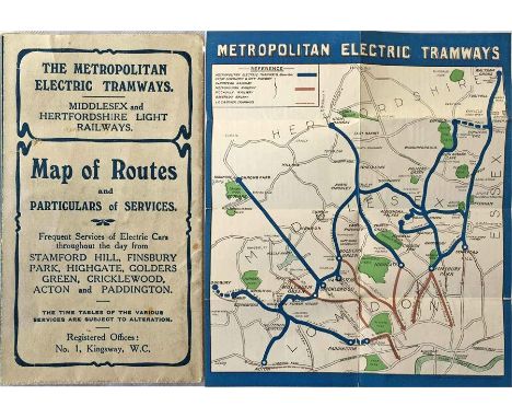
Early 20th century South Metropolitan Electric Tramways & Lighting Co Ltd ROUTE MAP & TIMETABLE. Pocket-sized, opens out to 17" x 13" (43cm x 34cm). Reverse has times, fares adverts. Undated but features the BET 'wheel & magnet' logo so we estimate it to approx 1905-1910. Short fold partings, some taped on the reverse but generally very good for its age. A very scarce item not seen at auction before. [1]

Lot 85
1937 London Transport Underground MAP. A special printing produced to accompany the 1937 Report & Accounts of the LPTB. Opens out to 24" x 18 " (61cm x 46cm), single-sided, and shows the system superimposed in black & red on a street map with the planned extensions to Ongar & Denham (Central Line) and to Alexandra Palace, High Barnet & Aldenham (Northern Line). A short fold parting at the bottom, otherwise in very good condition. [1]

Lot 283
Selection of 1920s-onwards Midland Red fold-out POCKET ROUTE MAPS comprising 'Map of Midland Red Routes', undated but marked '1927' (a little fragile with fold-partings), 'Map of Midland Red Country', undated but late-1920s/early 1930s (very good condition), 'Map of Midland Red Routes, Black Country & District', undated but 1930s (very good condition) and 'Midland Red Map of Routes', undated but 1950s (very good condition). [4]
Lot 23
1911 London Underground POCKET MAP loose-mounted in a thick-card frame for display (taped in position at one point on reverse). This edition shows the 3 separate Hammersmith stations, the CLR extension to Liverpool St under construction and the LBSCR lines to Crystal Palace. An ex-guidebook issue in very good condition. Measures 15" x 12" (38cm x 31cm) with frame. [1]
Lot 353
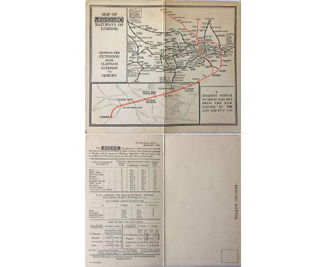
1926 card MAP OF THE UNDERGROUND RAILWAYS OF LONDON by F H Stingemore 'showing the extension from Clapham Common to Morden'. Dated 18/8/26, with fares and times on the reverse and in a form that, when folded, creates a 'printed matter' card that can be posted. 8" x 7" (20cm x 17cm) when open. Postally unused and in good condition. A most unusual item. [1]

Lot 325
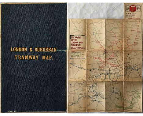
c1914 London & Suburban Tramways MAP, linen-backed inside leathercloth cover with gold-leaf title. Shows MET, LUT & SMET systems plus Underground Railways. Opens out to 13.5" x 17" (34cm x 43cm), in good condition. Contains, inside a pocket in the cover, the paper equivalent of the same map, a double-sided pocket map in lightly-used condition. A most unusual item. [2]

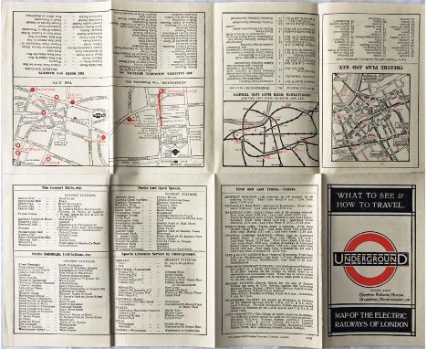
Lot 95
1909 London Underground STREET & RAILWAY MAP IN SECTIONS. A 54-page booklet featuring prominent use of the then recently-introduced UndergrounD logo and incorporating a coloured system map, a monochrome illustration of the 'No need to ask a p'liceman' poster, sectional street plans with the Underground lines superimposed and a street index. A very good example in lightly-used condition. [1]

Lot 93
Set of circa 1950s ROUTE MAP POSTERS issued by Western National & Southern National, Proprietors of Royal Blue Express Services, and each covering an operational area, these being Somerset & Dorset, Somerset & East Devon, Wiltshire, Cornwall, South Devon & East Cornwall and North Devon & North Cornwall. Illustrations of towns etc in the borders. Measure 30" x 20" (76cm x 51cm) and in good condition, folded, with some edge scuffs and wear. [6]


Lot 224
1944 London Underground POSTER MAP by H C Beck 'Underground Routes to and from the main-line stations'. Believed to have been produced largely for military personnel travelling during the build-up to D-Day. Below the Beck map is an index showing travel details from each main-line station to the others. Linen-backed and in superb condition, just faint traces of previous horizontal folds. A most unusual issue. [1]
![The "District [Railway] MAP of Greater London & Environs', first edition, dated 1902. From the series which ran from 1902 to](https://cdn.globalauctionplatform.com/6b494e3d-7c71-46b9-81ea-a73000fd00ba/265544e0-60eb-4243-9753-a79e0100c99c/468x382.jpg)
Lot 245
The "District [Railway] MAP of Greater London & Environs', first edition, dated 1902. From the series which ran from 1902 to c1908. A large-scale, fold-out map, paper on linen inside hard covers, it opens out to 42" x 26" (107cm x 66cm). The usual worn covers but the map is in good condition. [1]

Lot 351
1905 Central London Railway fold-out POCKET MAP produced to promote its service from Bank to Shepherds Bush. This is the much less-common issue marked "Revised Issue, 1905". The line is superimposed in red on a street-map background and shows the generating station and depôt at the western end with an inset plan of the subways at Bank on the top right. The reverse has travel and ticket information etc. In lightly-used condition with a small tape repair at one corner. [1]

Lot 267
1945 London Transport Underground MAP. A special printing produced to accompany the 1945 Report & Accounts of the LPTB. Bears the initials FHS, believed to be those of Fred Stingemore. Opens out to 20" x 17 " (51cm x 44cm), single-sided, and shows the planned extensions to Ongar & Denham (Central Line) and to Alexandra Palace & Bushey Heath (Northern Line). A couple of edge-nicks, otherwise in very good condition. [1]

Lot 215
1950s POSTER 'Associated Motorways Express Coach Routes'. Shows the network of coach routes on a map of England & Wales. Undated but the style and the illustration of a streamlined coach suggest early 1950s. Measures 20" x 29" (51cm x 73cm) and is in good condition with a little wear at the folds and some edges. [1]

Lot 88
1951 London Transport quad-royal POSTER MAP of central London, showing Underground, bus/tram/coach & main-line railways superimposed on a street-map. This issue also shows the various Festival of Britain sites. A detailed, high-quality map with the classic border of angled bullseyes, as posted at Underground stations and bus stops etc. Folded, a few edge-scuffs, a couple of very small fold-corner partings but generally a good example. [1]

Lot 68
British Empire Exhibition at Wembley items comprising the 1924 fold-out PLAN & MAP designed by Kennedy North in a style similar to MacDonald Gill with an Underground map with calligraphed station names and elaborate, colourful illustrations (lightly used) plus the 1925 "New Wembley...May - October" GUIDE (well-used, some fold-partings). [2]

Lot 213
1946 London Underground quad-royal POSTER MAP by H C Beck (whose names appears on the River Thames!) with a decorative border by 'Shep' (Charles Shepard). Largely in pre-war style, headed 'London's Underground', with the planned Central & Northern Line extensions to Ongar, West Ruislip, Bushey Heath and Alexandra Palace. 'This station' arrow sticker at Highgate. Previously folded, pin-holes etc at edges but generally very good. [1]

Lot 362
1911 London Underground POCKET MAP printed by Johnson, Riddle & Co Ltd. This edition shows the 3 separate Hammersmith stations, the CLR extension to Liverpool St under construction and the LBSCR lines to Crystal Palace. A genuine pocket-map issue with the correct folds and in excellent condition, a superb example. Opens out to 10.5" x 8" (27cm x 20cm) . [1]


Lot 264
Selection of 1930s/40s Southdown Motor Services Ltd TIMETABLE BOOKLETS comprising Official Time Table & Route Map dated 1 February 1930 (scuffed back cover, otherwise very good, fold-out map present), Official Bus Time Table dated 1 Jan 1936 (scuffed spine, otherwise very good, fold-out map present) and WW2 Emergency Time Table No 5 dated April 10th, 1941 (very good condition). [3]


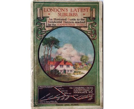
Lot 293
1910 GUIDEBOOK issued by the Charing Cross, Hampstead & Highgate Railway entitled "London's Latest Suburbs - an illustrated Guide to the Residential Districts reached by the Hampstead Tube". 108pp with a colourful illustration and map of the line on the cover. A most unusual item. Some age-staining and wear to the covers but generally in very good condition. [1]


Lot 237
1909 London Underground STREET & RAILWAY MAP. A 54-page booklet featuring prominent use of the then recently-introduced UndergrounD logo and incorporating a coloured system map, a monochrome illustration of the 'No need to ask a p'liceman' poster, sectional street plans with the Underground lines superimposed and a street index. In well-used condition with some wear, mainly to the cover. [1]

Lot 378
1937 London Passenger Transport Board large-scale MAP showing trolleybus routes, existing, authorised and proposed. Shows all the planned south London network, Kingsway Subway, Alexandra Palace spur plus all depôts and a proposed link between Highgate and East Finchley. Opens out to 32" x 25" (82cm x 64cm), in excellent condition. Plus a 1934 MAP of Central Bus Routes, special edition ex LT Annual Report, 23" x 17" (59cm x 45cm) in excellent condition. [2]

Lot 261
Selection of 1920s-40s Southdown Motor Services Ltd fold-out ROUTE MAPS comprising Route Map & Guide (undated but late 1920s), Pictorial Map designed by Cedric Buxton (undated but 1920s style) and 2 x 'Services throughout Sussex' Route Maps of Omnibus & Express Coach Services (neither dated but early post-WW2). In good to very good condition, the second has a few annotations to the routes list. [4]

Lot 365
1889 (September) Murray's TIME TABLE DIARIES - District & Metropolitan Railways. A small, pocket BOOKLET containing timetables for the two first Underground railways plus Thames tide tables, period advertisements for steamers, the Crystal Palace etc and a fold-out UNDERGROUND MAP 'District Railway Miniature Map of London'. Some signs of age but generally very good, no material damage. A most unusual item. [1]

Lot 122
London Underground linen-card POCKET MAP from the Stingemore-designed series of 1925-32. This is the 1932 last issue (the final pre-Beck Underground map) with mustard cover and showing all the line extensions completed with opening dates on the reverse. Some small grease stains on the cover but otherwise in very good condition, just lightly used. [1]

Lot 13
c1902 Central London Railway fold-out POCKET MAP produced to promote its service from Bank to Shepherds Bush. The line is superimposed in red on a street-map background and shows the generating station and depôt at the western end with an inset plan of the subways at Bank on the top right. The reverse has travel and ticket information etc. Slight wear at the folds and edges but overall a very good copy. [1]

Lot 79
c1902 linen-backed, fold-out MAP 'The Tramways of London'. Appears to have been prepared by LCC Tramways for official use. Measures 36" x 26" (93cm x 66cm) and shows the LCC boundary superimposed on a streetmap background with existing LCC routes, those authorised under the 1901/02 Acts, many horse-drawn routes not belonging to the LCC, Brixton Hill cable tram etc. A fascinating & unusual map in good, lightly-used condition, worn covers. [1]


Lot 327
1910 London Underground BOOKLET 'Aids to Travel' Winter Season 1910-1911, a 32pp publication compiled by the London Electric Railways and containing a fold-out copy of the 1909 official Underground Map. Booklet has some cover-wear and an annotation on the front, the map is in excellent condition. [1]
-
109182 item(s)/page