
Blome (Richard). A collection of eight county maps, circa 1673, engraved maps, comprising of Monmouth, Bedfordshire, Cumberland, Huntingdonshire, East Riding of Yorkshire, Jersey, Staffordshire and Hampshire, three (Hampshire, Cumberland & Monmouth) with later hand colouring, some staining and marginal closed tears, each approximately 305 x 260 mm apart from Jersey which is cut from a larger map and is 120 x 175 mm, together with Saxton (Christopher & W Kip & G. Hole). A collection of five county maps, circa 1637, six engraved map comprising of Herefordshire, Staffordshire, Buckinghamshire, Wiltshire, Nottinghamshire and The West Riding of Yorkshire, all hand coloured apart from Herefordshire, some staining and marginal fraying, Nottinghamshire laid on card, Wiltshire and the West Riding mounted, each approximately 270 x 325 mmQty: (14)
We found 109182 price guide item(s) matching your search
There are 109182 lots that match your search criteria. Subscribe now to get instant access to the full price guide service.
Click here to subscribe- List
- Grid
-
109182 item(s)/page
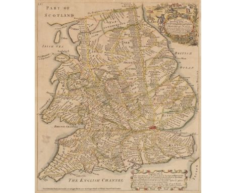
Bowles (John, publisher). Ogilby's Travellers Guide: or Gentleman's Pocket Companion through all the Direct and principal Cross Roads in England and Wales..., Printed for John Bowles in Cornhill & Carington Bowles next the Chapter House..., circa 1732 - 52, hand coloured engraved map with a decorative cartouche and a separate strapwork cartouche with an explanation, old folds and slight overall toning, 330 x 285 mmQty: (1)NOTESA diagrammatic road map, with a title that matches R. W. Shirley, Printed Maps of the British Isles 1650 -1750, Bowles 5, but the publication line is different. It is also similar to Shirley's Anon.6 but with a different cartouche and lacking the explanatory text below the map, and again it has similarities with Moll 2 but the title does not match. A similar map is illustrated in Francis Bennet's 'The Roads of Devon and Cornwall' but it has a compass rose in the Bristol Channel, lacking on this version. It is possible that the map was published for an edition of Moll's atlas but this is supposition. Undoubtedly rare if somewhat elusive.
British Isles. Speed (John), Britain as it was devided in the tyme of the Englishe Saxons especially during their Heptarchy, John Sudbury and George Humble, circa 1627, hand coloured engraved map, strapwork cartouche, compass rose and numerous rhumb line, the vertical borders decorated with 14 historical scenes, central fold repaired on verso, with slight worming at base of fold, margins repaired on verso,385 x 510 mm, English text on versoQty: (1)NOTESR. W. Shirley. Early Printed Maps of the British Isles, 317.

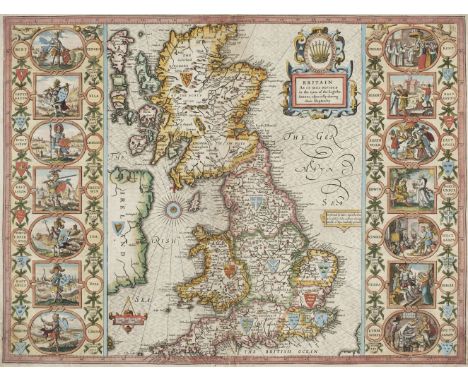
British Isles. Speed (John), The Kingdome of Great Britaine and Ireland, John Sudbury & George Humble, circa 1627, hand coloured engraved map, inset views of London & Edinburgh and an inset map of the Orkney Islands, central fold repaired and strengthened on verso, some repaired wormholes at base of central fold, margins repaired on verso, 380 x 510 mm, English text on versoQty: (1)NOTESR. W. Shirley. Early Printed Maps of the British Isles, 316.

British Isles. Zatta (Antonio), Britannicae Insulae in quibus Albion seu Britannia Major et Ivernia seu Britannia Minor, Venice, 1785, engraved map with contemporary outline colouring, 320 x 415 mm, together with Li Regni D'Inghilterra e D'Irlanda di nuova Projezione, Venice, 1776, engraved map with contemporary outline colouring, 310 x 405 mm, with Vuillemin (Alexandre). Nouvelle carte Illustrée des Iles Britanniques (Grande Bretagne, Écosse, Irlande)..., Paris, 1837, engraved map with contemporary outline colouring, inset maps of the Channel Islands and the Shetland Islands, the horizontal borders decorated with 14 uncoloured engraved topographical vignettes, old folds, 850 x 600 mm, with Pinkerton (John). British Isles, Cadell & Davies, 1812, engraved map with contemporary outline colouring, some damp staining to right hand vertical margin, one small repaired marginal closed tear, 700 x 510 mm, plus Dower (John & Weller Edward). Map of Great Britain showing all the Railways & Railway Stations, the Canals, Navigable Rivers & Principal Roads, Steam Packet Routes & Distances &c. Cassell, Petter & Galpin, circa 1867, large lithographic map with contemporary outline colouring, printed on four sheets but not conjoined, each sheet approximately 665 x 475 mm, with another copy similar, and an untitled uncoloured engraved map after Paul Rapin, trimmed with slight loss to printed margin, 375 x 280 mmQty: (7)

Cambridge. Braun (Georg & Hogenberg Franz), Cantebrigia opulentissimi Anglie Regni urbs celeberrimi nominsis ab Academie conditore Cantabro cognominata..., circa 1575, engraved map with contemporary hand colouring, large strapwork cartouche, some creasing, 335 x 450 mm, Latin text on versoQty: (1)NOTESOriginally published in Civitates Orbis Terrarum.
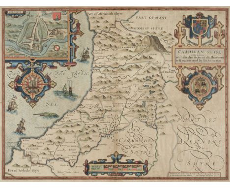
* Cardiganshire. Speed (John), Cardigan Shyre described with the due forme of the shire town as it was surveyed by J. S. Anno 1610, John Sudbury & George Humble, [1627], hand coloured engraved map, inset town plan of Cardigan, large strapwork cartouche, compass rose and mileage scale, good margins, slight dust soiling, 385 x 505 mm, framed and double-glazed, English text on versoQty: (1)

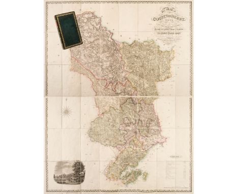
Derbyshire. Sanderson (George). This map of the County of Derby from a Careful Survey made in the years 1834 and 1835, is with the greatest respect inscribed to John Coke Esqre. Of Debdale, One of His Majesty's Justices of Peace for the County, 1st edition, published Septr. 15, 1836, engraved large scale map with bright contemporary hand colouring, sectionalised and laid on linen on two sheets, calligraphic cartouche, compass rose, table of explanation and an uncoloured engraved view of Haddon Hall, contemporary green card endpapers, each sheet 780 x 1210 mm, contained in a contemporary morocco gilt book box with contrasting morocco label to spineQty: (1)NOTESProvenance: The Estate of the late David Wilson (1926-2020). An uncommon large scale map in very good condition. Similar in style to the Greenwood map which had been published eleven years earlier but with greater detail. Sanderson is probably best known for his monumental circular wall map of '20 Miles round Mansfield'

Dorset. Saxton (Christopher & Lea Philip), Dorsetshire Described by C. Saxton. Corrected and Amended with many Additions as Roads &c. by P. Lea, circa 1693, engraved map with sparse outline colouring, an inset town plan of Dorchester, additional horizontal fold, trimmed with slight loss to right-hand vertical strapwork margin, slight dust soiling, 380 x 540 mm, together with Speed (John). Dorsetshyre with the Shyre-towne Dorchester described as also the Armes of such noble families as have bene honored with the titles thereof since the Normans Conquest to this present Anno 1662, Henry Overton, [1713 or later], uncoloured engraved map, an inset town plan of Dorchester, old folds, some cracking and small holes along folds, heavily stained, torn with loss to strapwork margin in the upper right corner, replaced in facsimile, 385 x 510 mm, no text on verso, with Saxton (Christopher & Kip William). Dorcestriae comitatis vulgo Dorsett ubi olim Durotriges Insererunt, [1637], hand coloured engraved map, large strapwork cartouche and mileage scale, two wormholes affecting image, some marginal fraying and repaired closed tears, 275 x 385 mm, plus Jansson (Jan). Comitatus Dorcestria vulgo Anglice Dorset Shire, Amsterdam, circa 1650, engraved map with contemporary outline colouring, decorative cartouche and mileage scale, some staining, some oxidisation to old watercolour causing some cracking and splitting to the printed surface, some abrasion to the printed surface causing loss, 380 x 495 mm, Latin text to versoQty: (4)

* Dorset. Speed (John), Dorsetshyre with the Shire-towne Dorchester described, as also the Armes of such noble families as have bene honoured with the Titles thereof since the Normans Conquest to this present, 1st edition, [1611], hand coloured engraved map, inset town plan of Dorchester, strapwork cartouche and mileage scale, 385 x 515 mm, mounted, framed and double glazed, English text on versoQty: (1)
![* East Indies. Mercator (Gerard & Hondius Henricus), India Orientalis, [1606 or later], engraved map with contemporary ou](https://cdn.globalauctionplatform.com/27556d06-14f1-4e11-85a7-ac1e00d5ce41/c21b1f6a-102e-4f6c-a6f1-ac1e010529f3/468x382.jpg)
* East Indies. Mercator (Gerard & Hondius Henricus), India Orientalis, [1606 or later], engraved map with contemporary outline colouring, large strapwork cartouche and mileage scale, some oxidisation of the old watercolour causing cracking, splitting and some loss to the printed surface, 355 x 485 mm, mounted, framed and glazedQty: (1)

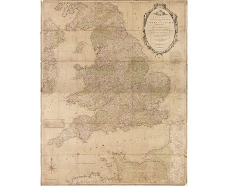
England & Wales. Carington Bowles (publisher), Bowles's New and Accurate Map of England and Wales Comprehending all the Cities, Boroughs, Market and Sea-Port Towns, Villages, Lakes, Rivers, Forests, Ruins and Principal Seats of the Nobility; with the roads described by Daniel Paterson..., 1782, large engraved map on two sheets, sectionalised and laid on later linen. large decorative cartouche and compass rose, inset map of the Scilly Isles, some fraying to margins with slight loss, toned overall, some fraying with slight loss where old folds cross, some dust soiling and staining, overall size 1290 x 1010 mmQty: (1)

England & Wales. De Vaugondy (Robert), Le Royaume D'Angleterre divisé selon les sept Royaumes ou Heptarchie de Saxons avec la Principauté de Galles; et subdivisé en Shires ou Comtés, Paris, 1753, engraved map with contemporary outline colouring, large uncoloured decorative cartouche, 485 x 525 mm, together with Kitchin (Thomas). An Accurate Map of Great Britain from the latest and best observations, circa 1770, uncoloured engraved map, old folds, 395 x 300 mm, with another hand coloured copy with some repaired closed tears, with A New & Accurate Map of the Roads of England and Wales with the Distances by the Mile Stones..., circa 1770, uncoloured engraved map, old folds, some staining, 345 x 350 mm, plus Kitchin's most Accurate Map of the Roads of England and Wales..., circa 1763, engraved map with sparse outline colouring, old folds, some staining, long repaired marginal closed tear affecting image, 345 x 345 mm, and Wyld (James). Wyld's A Map of England, Wales & Scotland describing all the Principal Cross Roads in Great Britain..., circa 1840, engraved map with contemporary outline colouring, inset map of Scotland, slight dust soiling, old folds strengthened on verso, repaired marginal closed tears, 730 x 615 mm, together with Brion de la Tour (Louis). L'Angleterre divisée en 5 Grandes partis, subdivisées en 52 Comtes..., Paris 1766, engraved map with contemporary outline colouring, descriptive text (printed from separate sheets) pasted to vertical margins, central fold repaired on verso, 290 x 485 mm, and Weidner (I. G. L.). Charte der Vereinigten Konigreiche Gros Britanien und Ireland..., 1804, engraved map with contemporary outline colouring, three inset columns of descriptive text, some water staining, 595 x 484 mmQty: (8)

England & Wales. Kitchin (Thomas), An Accurate Map of England and Wales, Drawn from all the particular Surveys hitherto published, Illustrated with many additional Improvements..., printed for John Bowles and Carington Bowles, circa 1760, large engraved map with bright contemporary hand colouring on two sheets, inset map of the Scilly Isles and table of explanation, large uncoloured allegorical cartouche, old folds, two folds strengthened on verso, each sheet approximately 600 x 1000 mmQty: (1)
![England & Wales. Munster (Sebastian), Das Ander Buch Beschrebung Engellandts und Schottlandts, [1578 or later], uncoloure](https://cdn.globalauctionplatform.com/27556d06-14f1-4e11-85a7-ac1e00d5ce41/4fcd3214-817c-44ad-b096-ac1e01052cf1/468x382.jpg)
England & Wales. Munster (Sebastian), Das Ander Buch Beschrebung Engellandts und Schottlandts, [1578 or later], uncoloured woodblock map, closed tears affecting image, repaired on verso, map size 250 x 170 mm, German text on verso, together with Saxton (Christopher & Hole G.). Englalond Anglia Anglo Saxonum Heptarchia, [1637], uncoloured engraved map, printer's fold, short closed tear just affecting image, slight creasing, 275 x 320 mm, with Ruscelli (Girolamo). Anglia et Hibernia Nova, Venice [1561 or later], uncoloured engraved map, central fold repaired and strengthened on verso, slight worming, torn with slight loss at base of central fold, repaired on verso, map size 250 x 180 mm, Italian text on verso, plus Kitchin (Thomas). A New and Accurate Map of the District of Great Britain called England & Wales &c. from the latest & most correct surveys..., published Alex Hogg, circa 1785, uncoloured engraved map, old folds, some creasing and marginal fraying, 385 x 335 mmQty: (4)

* England & Wales. Rocque (John), England and Wales drawn from the most accurate surveys containing all the Cities, Boroughs, Market Towns & Villages..., Laurie & Whittle, 12th May 1794, large engraved map with contemporary outline colouring and some later enhancement on two sheets, inset map of the Scilly Isles, large allegorical cartouche, old folds, slight creasing, occasional repaired closed tears, laid on card, 1180 x 985 mm, framed and glazedQty: (1)
![* England & Wales. Saxton (Christopher & Hole G.), Englalond Anglia Anglo Saxonum Heptarchia, [1637], hand coloured e](https://cdn.globalauctionplatform.com/27556d06-14f1-4e11-85a7-ac1e00d5ce41/de5651ee-9110-4bca-a2b6-ac1e01052e4a/468x382.jpg)
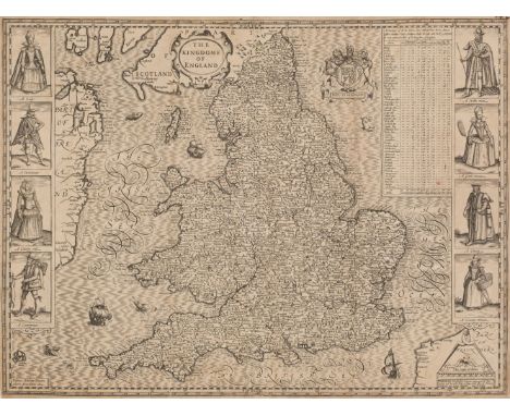
England & Wales. Speed (John), The Kingdome of England, 1st edition, John Sudbury & George Humble, 1611, uncoloured engraved 'carte-a-figure' map with eight costumed figures to vertical margins, old folds, some cracking and slight loss along folds, some thinning to printed surface strengthened on verso, some marginal fraying and short closed tears, slight spotting, 385 x 515 mm, English text on verso, together with another later hand coloured copy, some creasing , several repaired closed tears, partial loss to border along upper margin, 385 x 515 mm, no text on verso, with Britain as it was devided in the tyme of the Englishe Saxons especially during their Heptarchy, John Sudbury & George Humble, [1627], engraved map with early hand colouring, elaborate strapwork cartouche, compass rose and numerous rhumb lines, the vertical borders decorated with fourteen historical scenes, toned and stained overall, margins frayed and with several closed tears causing slight loss, central fold repaired on verso, 380 x 505 mm, English text on verso, plus Blaeu (Johannes). Magnae Britanniae et Hiberniae Tabula, Amsterdam, circa 1648, hand coloured engraved map, inset map of the Orkney Islands, toned overall with some staining, central fold strengthened on verso, repaired closed tear affecting image, two small holes along central fold, slight creasing, 390 x 500 mm, German text on verso, and Anglia Regnum, Amsterdam, circa 1645, engraved map with contemporary outline colouring, additional horizontal fold, slight creasing and spotting, old adhesion scars to verso, 385 x 500 mm, Dutch text on versoQty: (5)
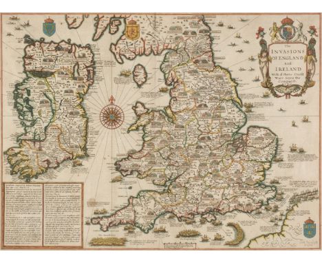
* England, Wales & Ireland. Speed (John), The Invasions of England and Ireland, with al their Civill Wars since the Conquest, Thomas Bassett & Richard Chiswell, [1676], hand coloured map, engraved by Cornelius Danckertz, table of explanation decorative cartouche, compass rose and numerous rhumb lines, slight spotting, 380 x 515 mm, mounted, framed and double-glazed, glass cracked on verso, English text to versoQty: (1)

Essex. Blaeu (Johannes), Essexia comitatus, Amsterdam, Amsterdam, circa 1648, engraved map with contemporary outline colouring, decorative cartouche and mileage scale, slight spotting but largely confined to margins, 415 x 525 mm, Latin text on verso, together with another uncoloured example of the same map, some separation to the central foldQty: (2)

Europe. Munster (Sebastian), Europa das ein Drittheil der Erde nach gelegenheit unserer zeit beschrieben, Basel, S. H. Petri, circa 1588, uncoloured woodblock map, slight staining, wide margins with slight spotting, central fold professionally strengthened on verso, 320 x 365 mm, German text on versoQty: (1)


Smith (C.). Smith's New General Atlas being a reduction of his large quarto atlas containing Maps of all the Empires, Kingdoms & States throughout the World, 1813, calligraphic title with an initial 'C' in a juvenile hand, contents list and 33 (complete as list) engraved maps with contemporary outline colouring, a wormhole to first three maps, some marginal dust soiling, pencil annotations and staining, map of Germany torn along the old fold, old newspaper cutting and ownership signatures to front endpaper, contemporary half calf, upper board detached, heavily worn and frayed, slim 4toQty: (1)NOTESSold as a collection of maps, not subject to return.
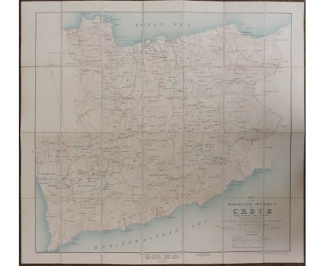
Folding Maps. A mixed collection of seventeen maps, mostly 19th century, including Nantiat (Jaspar). A New Map of Spain and Portugal Exhibiting the Chains of Mountains with their Passes, The Principal & Cross Roads with other details requisite for the Intelligence of Military Operations, W. Faden, Jany. 1st. 1810, engraved map with contemporary outline colouring, sectionalised and laid on linen on four sheets, calligraphic cartouche and advertisement, slight dust soiling and offsetting, ink manuscript on verso 'Lieut Griffiths, 94th Regt. DA2 M.G., each sheet approximately 560 x 780 mm, contained in a contemporary cloth gilt slipcase, case worn, frayed and split along seams, together with Simmons (J. L. A. Captain Royal Engineers). Map of England and Wales showing the Railways, Canals & Inland Navigation Compiled from the Ordnance Surveys and other sources. For the use of the Lords of the Committee of Privy Council for Trade &c., 1852, large engraved map with contemporary outline colouring, sectionalised and laid on linen, slight spotting, 1725 x 1450 mm, contemporary half calf, spine rebound in near-contemporary cloth with morocco gilt labels, brass clasp, heavily worn and frayed with upper board near detached, binding 335 x 210 mm, with Downes W. D. 2nd. Lieut. Royal Sussex Regt.). Map of the Herakleon District of Crete from a Plane Table Survey, Edward Stanford Ltd for the Geographical Section, General Staff War Office, May 1907, colour lithographic map, sectionalised and laid on linen, 635 x 665 mm, marbled endpapers and printed label with manuscript title to upper cover, with another fourteen folding maps, mostly of Egypt, North and Central Africa, various sizes and conditionQty: (17)
Folding maps. A mixed collection of ten folding maps, mostly 19th century, including Cruchley (G. F.). Cruchley's Improved Geographical Companion throughout England & Wales including part of Scotland, 1825, engraved map with contemporary outline colouring, sectionalised and laid on linen, three tables of reference and a table of explanation, slight off-setting, 940 x 650 mm, marbled endpapers, contemporary card slipcase with printed label to upper cover, case split and worn, together with Colton & Co. (Publisher). Colton's England and Wales, 1878, engraved map with contemporary outline colouring, laid on linen, inset map of the Scilly Isles, old folds, slight staining, 640 x 430 mm, bound in contemporary cloth boards with gilt title to upper cover, with Bacon (G. W., publisher). New Plan of Dublin and Suburbs, circa 1900, colour lithographic map, old folds, 785 x 690 mm, bound in publisher's decorative red cloth boards with a ten page alphabetical index bound in before the map, plus Wyld (James). Map of Europe Exhibiting its Principal States and Physical Features, circa 1850, engraved map with contemporary outline colouring, sectionalised and laid on linen, 535 x 680 mm, marbled endpapers, with an incomplete (lacking 1 section of 12) Blacks new large Map of Scotland and a Stanford large scale map of Ireland (lacking 1 sheet of 4) with four others similar including examples by Ordnance Survey and Ward Lock and Co. various sizes and condition
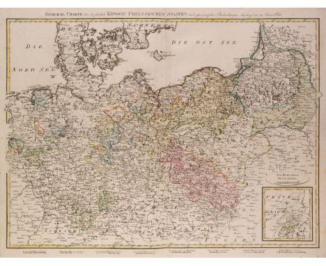
Germany. Walch (Johann, publisher), General Charte über die sämtlich Königlich Preussischen Staaten nach astronomischen Beobachtungen, Ausburg, 1797, engraved map with contemporary outline colouring, inset map of Neufchatel, eight mileage scales below map, slight marginal dust soiling and staining 475 x 625 mm, together with a later variant of the map published in 1806 and lacking the inserted map of Neufchatel which is replaced by a key plate, the second example with a manuscript title on the versoQty: (2)

* Gloucestershire. Speed (John), Glocestershire contrived into thirty thre severall hundreds & those againe into foure principall devisions. The Citie of Glocester & Bristowe discribed with the armes of such noble men as have bene dignified with ye titlles of Earles & Dukes thereof, Thomas Bassett & Richard Chiswell, [1676], hand coloured engraved map, inset town plans of Gloucester and Bristol, short repair at base of central fold, 380 x 510 mm, mounted, framed and double glazed, English text on verso, together with Saxton (Christopher & Hole G.). Glocestriae comitatus olim sedes Dobunorum, [1637], hand coloured engraved map, large strapwork cartouche, mileage scale and compass rose, 285 x 320 mm, mounted, framed and glazed, with Owen (John & Bowen Emanuel). Glocestershire, [1720 or later], hand coloured engraved map with descriptive text below image, 185 x 120 mm, mounted, framed and glazedQty: (3)NOTESA surprisingly dark impression - for the 1676 edition - well coloured and with good margins.

Hertfordshire. Speed (John), Hartford Shire Described. The sittuations of Hartford and the most ancient towne S Albons with such memorable actions as have happened, 1st edition, John Sudbury & George Humble, [1611], engraved map with contemporary outline colouring, inset town plans of Hertford and Verolanium (St. Albans), toned overall, slight text show through, 385 x 515 mm, English text on verso, together with Blaeu (Johannes). Hertfordia Comitatus vernacule Hertfordshire, Amsterdam, circa 1648, engraved map with contemporary hand colouring, decorative cartouche and mileage scale, some dust soiling and marginal spotting, 385 x 505 mm, Latin text on versoQty: (2)
![Hungary. Speed (John), The Mape of Hungari newly augmented..., Thomas Bassett & Richard Chiswell, [1676], hand coloured '](https://cdn.globalauctionplatform.com/27556d06-14f1-4e11-85a7-ac1e00d5ce41/d6d97932-97e0-49bc-bc0f-ac1e0105365d/468x382.jpg)
Hungary. Speed (John), The Mape of Hungari newly augmented..., Thomas Bassett & Richard Chiswell, [1676], hand coloured 'carte-a-figure' map with eight costumed figures to the vertical margins and four oval vignettes of the principal cities along the upper horizontal margin, central fold skillfully strengthened on verso 395 x 515 mm, English text on versoQty: (1)
![Isle of Wight. Speed (John), Wight Island, Thomas Bassett & Richard Chiswell, [1676], hand coloured engraved map, inset t](https://cdn.globalauctionplatform.com/27556d06-14f1-4e11-85a7-ac1e00d5ce41/658f8f05-8bbd-413f-81a1-ac1e0105371b/468x382.jpg)
![Kent. Morden (Robert), Kent, [1695 or later], hand coloured engraved map, large strapwork cartouche, old folds, one repaired](https://cdn.globalauctionplatform.com/27556d06-14f1-4e11-85a7-ac1e00d5ce41/874ed3f8-e7e6-43ba-bf5b-ac1e010537a7/468x382.jpg)
Kent. Morden (Robert), Kent, [1695 or later], hand coloured engraved map, large strapwork cartouche, old folds, one repaired marginal closed tear, 350 x 630 mm, together with Cary (John). A Map of the County of Kent taken from an actual survey as an index to the large one, [1769], engraved map with contemporary outline colouring, slight staining, produced as the key plate map for J. Andrews, A. Dury and W. Herbert's large scale map of Kent, 490 x 705 mmQty: (2)
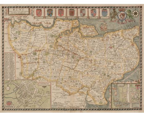
Kent. Speed (John), Kent with her Cities and Earles described and observed, Thomas Bassett & Richard Chiswell, 1676, hand coloured engraved map, inset town plans of Rochester and Canterbury, central fold strengthened on verso, repaired marginal closed tears, 380 x 510 mm, English text on verso, together with Jansson (Jan). Cantium vernacule Kent, Amsterdam, circa 1648, engraved map with contemporary outline colouring, decorative cartouche, compass rose and numerous rhumb lines, torn with very slight loss to the upper right corner, central fold strengthened and repaired on verso, some oxidisation to old watercolour causing some cracking and splitting, several repaired closed tears, 380 x 500 mm, Latin text on verso, with another copy with several long repaired closed tears, fraying with some loss and crude later hand colouring, Latin text on verso, plus Blaeu (Johannes). Cantium vernacule Kent, Amsterdam, circa 1665, engraved map with contemporary outline colouring, cartouche and heraldic shields remain uncoloured, ink manuscript 'J. Blaeu 1645' added to the cartouche, old watercolour oxidised resulting in some cracking and small holes affecting image, toned overall, 385 x 525 mm, no text on verso and Saxton (Christopher & Kip William). Cantium quod nunc Kent, [1637], hand coloured engraved map, strengthening to lower corners, some old card adhesion to upper corners, heavily toned overall, 280 x 380 mmQty: (5)

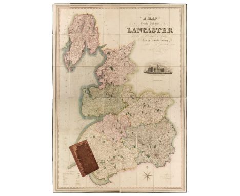
Lancashire. Hennet (G.), A Map of the County Palatine of Lancaster Divided into Hundreds and Parishes from an accurate Survey made in the years 1828 and 1829, Henry Teesdale & Co, May 1st. 1830, large scale map engraved by James Bingley, with bright contemporary hand colouring, sectionalised and laid on linen, large calligraphic cartouche, engraved vignette of the New Custom House Liverpool, compass rose and table of explanation, slight offsetting, edged in green silk, marbled endpapers, 1620 x 1130 mm, contained in a contemporary calf book box, the box is worn and frayedQty: (1)

Lancashire. Smith (William), Lancastriae comitatus Palatinus continens in se oppida Mercatoria XVI Ecclesiasque Parochiales tantum XXXVI des illae valde populosae et quae maximas albi paroecias Incolarum multitudine longe superant praeter plurimas capellas, J. Overton, circa 1675, hand coloured engraved map orientated to the east, large strapwork cartouche, table of explanation and mileage scale, one small marginal repaired closed tear, 370 x 470 mmQty: (1)NOTESA scarce map prepared for a county atlas which was never published and here re-issued by John Overton for a composite atlas. Smith only managed to make twelve county maps and all are uncommon on the market.

Lancashire. Speed (John), The Countie Pallatine of Lancaster described and divided into Hundreds, George Humble, circa 1627, hand coloured engraved map, inset town plan of Lancaster and decorated with eight circular portraits of Plantagenet kings and queens, trimmed to neatline along upper margin, central fold strengthened and repaired on verso, some marginal repaired tears, 385 x 510 mmQty: (1)
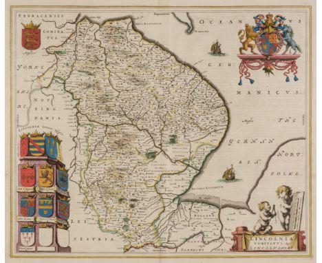
Lincolnshire. Jansson (Jan), Lincolnia Comitatus Anglis Lyncolne Shire, Amsterdam, circa 1648, engraved map with contemporary outline colouring, decorative cartouche and mileage scale, compass rose and numerous rhumb lines, short split at head of central fold, very slight spotting and text show through, 400 x 500 mm, French text on verso, together with Blaeu (Johannes). Lincolnia Comitatus Anglis Lincoln-shire, Amsterdam, circa 1645, engraved map with contemporary outline colouring, decorative cartouche and mileage scale, 425 x 505 mm, Dutch text on versoQty: (2)
London. Bowles & Carver, (publishers), Bowles's New one-Sheet Plan of the Cities of London and Westminster with the Borough of Southwark; comprehending the Outskirts and Extent of the Thames from Chelsea to Deptford Exhibiting also the New Buildings, Roads and other Alterations to the Year 1795, engraved map with contemporary outline colouring, sectionalised and laid on linen, some dust soiling and slight staining, linen split along one fold, 445 x 650 mm, contained in a contemporary card slipcase, case worn at extremities, together with Miller (R. publisher). London Westminster and Southwark, circa 1820, uncoloured engraved miniature map of London, bound with 3 (only topographical views and 'A Catalogue of Books & Fancy Articles Published and Sold by R. Miller 24 Old Fish Street, Doctors' Common', map size 80 x 115 mm, contemporary half calf over marbled boards, worn and frayed with upper board near detached, 12mo,Qty: (2)NOTESFirst item: Howgego, Printed Maps of London, 181. state 7.

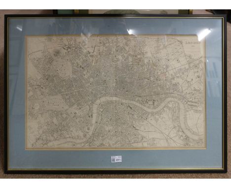
* London. Cruchley (G. F.), Cruchley's new plan of London improved to 1829, including the East and West India Docks, 1829, engraved map with contemporary outline colouring, sectionalised and laid on linen, slight fading and toning, 480 x 940 mm, mounted, framed and glazedQty: (1)NOTESJ. Howgego. Printed Maps of London 1553 - 1850, 304, state B4.
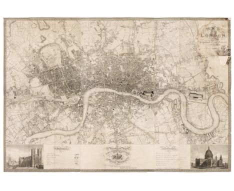
London. Davies (B. R.), London 1851, published S. D. U. K. circa 1852, uncoloured engraved plan of London 400 x 660 mm, mounted, framed and glazed, together with Starling (T.), Liverpool, published S. D. U. K., circa 1852, uncoloured engraved map, three inset views and plans, 310 x 390 mm, mounted, framed and glazed, with Birmingham. published S. D. U. K. circa 1852, uncoloured engraved plan, inset map of the environs of Birmingham, 330 x 405 mm, mounted, framed and glazed, plus Turrell (E.). Edinburgh, published S. D. U. K., circa 1852, uncoloured engraved plan, inset view of Edinburgh Castle, 315 x 405 mm, mounted and framed but lacking glass, and Jukes (Francis). Mr John Willis, Writing Master, circa 1790, uncoloured mezzotint, some spotting and dust soiling, laid on later card, 360 x 255 mm, mounted, together with Gauci (M.). Amheistia nobilis, Bombax insigne [and] Hibiscus macrophyllus, circa 1880, together three lithographs with contemporary hand colouring, two are approximately 460 x 325, and one is 355 x 500 mm, uniformly mounted, framed and glazed, with Harris (Moses). Plate XIV from 'The Aurelian. A Natural History of English Insects...', circa 1778, engraving with contemporary hand colouring, some spotting, 295 x 235 mm, mounted, framed and glazed, with another six prints and maps, various sizes and conditionQty: (14)
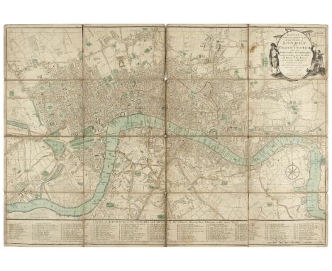
London. Greenwood (C. & J.), Map of London from an Actual Survey made in the years 1824, 1825 & 1826..., Published by the Proprietors, Greenwood Pringle & Co., 1st edition, August 21, 1827, uncoloured map engraved by James & Josiah Neele in 36 sections, laid on later card in six parts, calligraphic cartouche and table of explanation, dedication to George IV, inset views of St Pauls and Westminster Abbey, damp staining around the title has caused discolouration and fraying with some loss to the printed surface, other small areas of loss where old folds cross, overall size 1240 x 1825 mmQty: (1)NOTESHowgego, Printed Maps of London 1553 - 1850, 309, state 1. The Greenwood brothers Christopher and John spent three years preparing this remarkable new survey of London, prepared on the lavish scale of 8 inches to a mile, illustrating for the first time the planned development of Belgravia by Thomas Cubitt, the completion of the Grand Surrey Canal and Regent's Park one year before it was completed in 1828.


Map Reference. A collection of approximately 75 volumes, 20th century, map reference and facsimile atlases, including examples by Manasek, Lister, Swift, Blake, Potter and Baynton-Williams, including Wallis (Helen, editor). The Maps and Text of the Boke of Idrography presented by Jean Rotz to Henry VIII, facsimile edition, published Oxford for Presentation to the Members of the Roxburghe Club, 1981, numerous colour plates, publisher's half morocco gilt, slight wear to extremities, large folio, together with two cartons of map related periodicals including broken runs of The Map Collector, The Imcos Journal, Imago Mundi and Mercators World, various sizes and conditionQty: (approx. 75 and 2 cartons)

* Maps. A mixed collection of eight maps, 17th - 19th century, including Saxton (Christopher & Kip William). Sussexia sive Southsex olim pars Regnorum, [1637], hand coloured engraved map, strapwork cartouche and mileage scale, trimmed to the image along vertical margins, 225 x 385 mm, mounted, framed and glazed. together with Saxton (Christopher & Hole G.). Frugiferi ac ameni Herefordiae comitatus qui olim pars suit Silurum delineatio, [1637], hand coloured engraved map, strapwork cartouche and mileage scale, 290 x 310 mm, mounted, framed and glazed, with Morden (Robert). Essex [1695 or later], hand coloured engraved map, slight offsetting, 345 x 420 mm, mounted, framed and glazed, plus Van den Keere (Pieter). Midle-sex [and] Wight island, [1627 or later], two hand coloured engraved maps, each approximately 80 x 120 mm, mounted, framed and glazed, and Moule (Thomas). Buckinghamshire [and] Berkshire, circa 1848, two hand coloured engraved maps, each approximately 260 x 195 mm, mounted, framed and glazed, with Rocque (John). Herefordshire, circa 1753, uncoloured engraved map, 160 x 205 mm, mounted, framed and glazed, together with three map reference books, comprising of Yasha Beresiner's 'British County Maps Reference and Price Guide, Nigel Nicholson's The Counties of Britain A Tudor Atlas by John Speed and a facsimile atlas of Christopher Saxton's 16th-century maps with an introduction by William Ravenhill, various sizes, condition G/VGQty: (11)
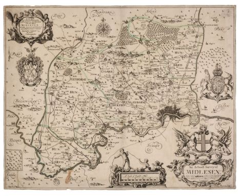
Middlesex. Ogilby (John), An Actuall Survey of Midlesex, George Willdey, circa 1732, engraved map by Walter Binnerman with sparse outline colouring, large title cartouche and dedication, compass rose and two armorial coats of arms, trimmed to neatline, slight staining, old folds with some strengthening on verso, small abraided hole in mileage scale, slight marginal fraying, slight adhesion scaring to verso, 415 x 525 mm, together with Norden (John, after). Middlesex olima Trinoban Tibus habitata, [1637], uncoloured engraved map, large strapwork cartouche and table of explanation, some staining to central fold, 270 x 335 mmQty: (2)

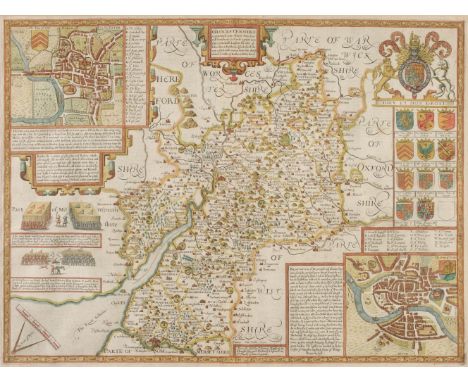
Middlesex. Smith (Joseph), The County of Middlesex Actually Survey'd and Delineated and Newly Corrected & Amended with many Additions..., 1714, large map with contemporary outline colouring engraved by John Oliver, trimmed to neatline, small repaired closed tears affecting image, old folds partially strengthened on verso, slight staining, 585 x 905 mmQty: (1)NOTESA scarce map engraved for a never-completed atlas. Only six counties were ever finished:- Middlesex, Surrey, Hertfordshire, Kent, Buckinghamshire and Oxfordshire, the project presumably failing due to financial problems.
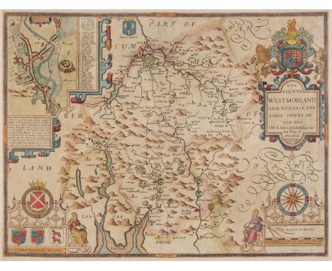
Northern Counties. Speed (John), The Countie of Westmorland and Kendale the cheif towne described, Henry Overton, circa 1743, hand coloured engraved map, an inset town plan of Kendal, large strapwork cartouche, mileage scale and compass rose, trimmed to neatline with margins extended, 380 x 505 mm, no text on verso, together with The Bishoprick and Citie of Durham, 1st edition, [1611], uncoloured engraved map, an inset town plan of Durham, torn with very slight loss to strapwork margin at the lower right corner, long repaired closed tear affecting image, slight thinning to paper but with no loss, 380 x 505 mm, English text on verso, with The North and East Ridins of Yorkshire, published John Sudbury & George Humble, circa 1627, hand coloured engraved map, inset town plans of Richmond and Hull, some marginal fraying with slight loss to strapwork margin, slight staining, slight abrasion to the printed surface, small margins, 390 x 515 mm, English text on versoQty: (3)
Northern Europe. Lange (Johann Elias), Neue Karte den gegenwartigen Kriegs-Schauplatze zwischen den Russisch. Kayserl: und Königl: Schwedischen Armeen und Flotten,welche vorzu?gl. ganz Finland, Liefland, Estland, Ingermanland, ein Theil von Pohlen und Rusland, Ost- und West-Preussen,die Ost See, Dännemark, Schweden, Norwegen, und ein Theil von Deutschland, nebst denen bisherigen Stellungen gedachter Armeen enthält, Leipzig,1788, engraved map with contemporary outline colouring, three inset maps of the eastern Gulf of Finland, Savonlinna (Plan von Nyslot) and Vyborg (Wyborg), inset text describing the Russo-Swedish war (1788 - 1790), slight overall toning, very slight creasing, 415 x 480 mmQty: (1)NOTESA rare historical-military map published during the Russo-Swedish War (1788 - 1790) giving detailed information concerning the war.

* Ogilby (John). The Continuation of the Road from London to the Lands End, Plate 2d, commencing at Andover com. Hants & extending to Crookhorn com. Somerset..., circa 1675, uncoloured engraved strip road map, 325 x 445 mm, framed and glazedQty: (1)NOTESThe road commences at Andover and runs through Winchester, Salisbury, Shaftesbury, Sherborne and Yeovil and ends at Crewkerne. Sheet number 26.
![Ogilby (John). The Road from Bristol co. Glouc. to Banbury com Oxo. [1675 or later], uncoloured engraved strip road map, slig](https://cdn.globalauctionplatform.com/27556d06-14f1-4e11-85a7-ac1e00d5ce41/b7db74a1-f430-4eb0-9653-ac1e010549ed/468x382.jpg)
Ogilby (John). The Road from Bristol co. Glouc. to Banbury com Oxo. [1675 or later], uncoloured engraved strip road map, slight mount staining, 335 x 445 mm, supplied with the contemporary sheet of descriptive textQty: (2)NOTESThe road commences at Bristol and runs through Chipping Sodbury, Tetbury, Cirencester, Bibury, Burford, Shipton-under-Wychwood and Bloxham and ends at Banbury. Sheet number 55.
![* Ogilby (John). The Road from London to Barstable in Devonshire, [1676 or later], hand coloured engraved strip road map, 'fo](https://cdn.globalauctionplatform.com/27556d06-14f1-4e11-85a7-ac1e00d5ce41/29c4b65f-bcf7-42ce-a476-ac1e01054a95/468x382.jpg)
* Ogilby (John). The Road from London to Barstable in Devonshire, [1676 or later], hand coloured engraved strip road map, 'fox-hunting cartouche', 365 x 445 mm, framed and glazed, together with a hand coloured engraved smaller version of the same map by John Senex with another road map (The Continuation of the Road from London to Barnstable in Devonshire) printed on the verso, 165 x 210 mm, mounted framed and double glazed, with Owen (John & Bowen Emanuel). Untitled road map, [1720 or later], hand-coloured engraved strip road map running from Chippenham to Wells and on the verso from Marlborough to Wells, 185 x 120 mm, mounted, framed and double glazed, below the map inset into the mount is a brass 'Bath Token', dated 1811 and decorated with 'the golden fleece' of a lamb hanging from a ribbon and on the verso the legend ' A pound note for every 240 tokens given by S. T. Whitchurch and W. Dore', 35 mm in diameterQty: (3)NOTESThe first described item is Sheet 32. The road commences at Andover and runs through Market Lavington, Warminster and Bruton and ends at Bridgewater

![Ogilby (John). The Road from London to St Davids in com Pembroke, [1676 or later], hand coloured engraved strip road map, lai](https://cdn.globalauctionplatform.com/27556d06-14f1-4e11-85a7-ac1e00d5ce41/59ae5495-32c2-43a1-acac-ac1e01054bd4/468x382.jpg)
Ogilby (John). The Road from London to St Davids in com Pembroke, [1676 or later], hand coloured engraved strip road map, laid on card, toned overall,300 x 450 mmQty: (1)NOTESThe road commences in London and passes through Brentford, Hounslow, Stowe, Maidenhead, Henley, Nettlebed and Dorchester and ends at Abingdon. Sheet number 14.

Ogilby (John). The Road from Oxford to Cambridge, circa 1675, hand coloured engraved strip road map, decorative cartouche showing a surveyor using a waywiser, one small repaired hole affecting image, laid on later paper, 340 x 420 mmQty: (1)NOTESThe road commences at Oxford and runs through Bicester, Buckingham, Newport Pagball, Bedford and Gamlingay and ends at Cambridge.

* Oxfordshire. Blaeu (Johannes), Oxonium comitatus vulgo Oxford Shire, circa 1645, engraved map with bright contemporary hand colouring, large decorative cartouche and mileage scale and the vertical margins decorated with sixteen heraldic shields of Oxford colleges, 380 x 500 mm, French text and a hand coloured engraved view of the Rollright Stones on the verso, framed and double glazed, together with Blome (Richard). A Generall Mapp of the County of Oxford with its Hundreds, [1673], hand coloured engraved map, one wormhole affecting image, 335 x 295 mm, framed and glazedQty: (1)NOTESA clean example in very good condition.

Oxfordshire. Blaeu (Johannes), Oxonium Comitatus vulgo Oxford Shire, Amsterdam, circa 1648, engraved map with contemporary hand colouring, heightened in gold, some overall toning, several wormholes repaired on verso, central fold strengthened on verso, the whole backed with archival tissue, 380 x 505 mm, Latin text on verso, together with Jansson (Jan). Oxonium Comitatus vulgo Oxfordshire, Amsterdam, circa 1655, engraved map with contemporary hand colouring, slight overall toning, margins stained but not affecting image, 380 x 485 mm, no text on verso, with Morden (Robert). Oxford Shire, [1695 or later], uncoloured engraved map, slight creasing and spotting, some fraying to margins, 420 x 360 mm with three other uncoloured engraved maps of Oxfordshire by Skelton, Cary and Harrison, various sizes and conditionQty: (6)

Oxfordshire. Speed (John), Oxfordshire described with ye Citie and the Armes of the Colledges of ye famous University, Thomas Bassett & Richard Chiswell [1676], u ncoloured engraved map, inset town plan of Oxford, the vertical margins decorated with 18 heraldic shields,390 x 525 mm, English text on verso, together with Saxton (Christopher & Hole G.), Oxoniensis comitatus vulgo Oxfordshyre qui pars olim Dubunorum, [1610], uncoloured engraved map, large strapwork cartouche, 275 x 290 mm, with Skelton (J., publisher). A Map of Oxfordshire to accompany Skelton's Engraved Illustrations of the Antiquities in the County, Oxford, 1827, uncoloured engraved map on India wove, slight spotting to margins, 300 x 225 mm, with another copy similarQty: (4)
-
109182 item(s)/page