English Counties. Walker (J. & C.), Hampshire, Middlesex, Dorset, Warwickshire, Herefordshire, Hertfordshire, Kent, Yorkshire (East Riding), Berkshire, c.1830s, together nine engraved folding maps, hand coloured in outline, some light spotting, approx. 340 x 420 mm, each contained in orig. cloth covers with paper labels to upper spine, some cracking at the joints, plus a similar folding map of Monmouth by William Darton. (10)
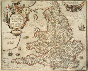
We found 109182 price guide item(s) matching your search
There are 109182 lots that match your search criteria. Subscribe now to get instant access to the full price guide service.
Click here to subscribe- List
- Grid
-
109182 item(s)/page
Folding maps. Back (J. & Sauter, C.), Carl Jugel's Post und Reise-Karte von Deutschland und den Nachbarstaaten, pub. Frankfurt, 1844, engraved folding map of Germany and much of Central Europe, sectionalised onto linen, hand coloured in outline with calligraphic title, inset map of Europe to lower right corner, approx. 1060 x 1240 mm, contained in orig. card slipcase with paper label to upper cover (rubbed), together with Royal Gazette Co. (pub.), Driving and Cycling Road Map of the Bermuda Islands, 4th ed, 1911, folding engraved map, a few short marginal tears, approx. 240 x 630 mm, contained within orig. printed boards, and others including a late 18th century Bowles & Carver folding map of the British Isles in poor condition, and others. (8)
Great Britain. Walker (J.), Map of the Inland Navigation, Canals, and Rail Roads with the Situations of the Various Mineral Productions throughout Great Britain, from actual surveys. accompanied by a Book of Reference, compiled by Joseph Priestley, Esqre, of the Aire and Calder Navigation, pub. Richard Nichols, Wakefield, January 1st 1830, hand-col. eng. map, sectionalised on linen, inset map of the North of Scotland, eng. title and dedication cartouche, compass rose, approx. 193 x 156 cms. overall, in orig. morocco slipcase, rubbed, large 8vo. (1)
Lancashire. Hennet (G.), A Map of the County Palatine of Lancaster Divided into Hundreds and Parishes from an Accurate Survey Made in the Years 1828 and 1829.Engraved by James Bingley, pub. Henry Teesdale, May 1st, 1830, hand coloured folding engraved map, sectionalised onto linen, calligraphic title, uncol. vignette of the New Custom House, Liverpool, the whole approx. 1630 x 1180 mm, contained in a contemp. tree-calf map box (heavily rubbed to extrems.). (1)
London. Cruchley (George Frederick, pub.), Cruchley's New Plan of London Shewing all the New and Intended Improvements to the Present Time, c.1851, hand coloured engraved folding map sectionalised onto linen, the whole approx. 440 x 850 mm, conatined in orig. cloth slipcase with orange paper label to upper cover (some minor wear to corners). Howgego 307 (20) showing the Great Exhibition in Hyde Park. Title on cover reads 'Cruchley's Superior Map of London.Improved to 1852'. (1)
London. Cruchley (pub.), From the Ordnance Survey of the Country Thirty Miles Round London, n.d, c.1840s, folding engraved map in four separate sheets, each hand coloured in outline and sectionalised onto linen, the whole approx. 1060 x 1320 mm, contained in orig. cloth slipcase with paper label (rubbed to extrems.). (1)
London. Philip (George, pub.), Philips' Tape Indicator Map of London, c.1900, colour printed folding map laid onto linen with attached tape measure in excellent condition, one or two clean fold splits, the whole approx. 620 x 900 mm, contained in orig. cloth boards with attached index booklet, together with another copy lacking the tape measure. (2)
London. Davies (B.R, pub.), Davies's Map of the Environs of London, 1855, folding engraved map, hand coloured in outline and sectionalised onto linen, approx. 760 x 1080 mm, contained in contemp. cloth slipcase, together with Ordnance Survey (pub.), London and its Environs, June 1861, engraved map, hand coloured in outline and sectionalised onto linen, approx. 730 x 1190 mm, contained in cloth slipcase with paper label to upper cover, and other folding maps maps of London 1880s-1910s, published by W.H.Smith, Bacon, Collins, Gall & Inglis, Ordnance Survey, etc. (17)
London. Smith (C, pub.), Indicator Map of London divided into Quarter Mile Squares, 1896-7, colour printed folding map with attached tape measure in excellent condition, approx. 520 x 770 mm, contained with index booklet in orig. dec. cloth (sl. rubbed to extrems.). Title to upper cover reads 'Tape Indicator Map of London and Visitors Guide'. (1)
London. Bacon (G.W, pub.), Bacon's New Map of London Divided into Half-Mile Squares and Circles from Charing Cross, c.1890s, folding colour printed map, laid onto linen, approx. 800 x 1010 mm, contained with index booklet in orig. cloth gilt, together other folding maps of London published by W.H.Smith, Philips, Whitbread and Cruchley. (7)
* British Isles. Ortelius (Abraham), Angliae, Scotiae, et Hiberniae, sive Britannicar: Insularum Descriptio, [1570 or later], engraved map of the British Isles with north oriented to the right, old hand colouring, ornamental strapwork title cartouche and a single armorial, tape repair to verso of foot of central fold, approx. 350 x 500 mm, framed and double-glazed, German black letter to verso. (1)
* Cheshire. Speed (John), The Countye Palatine of Chester with that Most Ancient Citie Described, sold Sudbury & Humble, [1611], engraved map with contemp. hand colouring, strapwork title surmounting armorial, inset plan of Chester and seven armorial shields, some discolouration of old paint, approx. 380 x 510 mm, framed and double glazed. (1)
* England & Wales. Ortelius (Abraham), Angliae Regni Florentissimi Nova Descriptio, Auctore Humfredo Lhuyd Denbygiense, 1573 [or later], engraved map, separate ornamental strapwork title and scale-of-distance cartouche, contemp. hand colouring, single worm-trail to lower margin not affectin printed image, approx. 375 x 470 mm, framed and double-glazed, Latin text to verso. (1)
English County maps. Saxton (Christopher & Kip, William), Wiltoniae Comitatus Herbida Planicie, [1637], hand coloured engraved map, strapwork title cartouche, approx. 280 x 350 mm, together with Northamtoniae Comitatus Descriptio, [1637], hand coloured engraved map, strapwork title and scale of distance cartouches, somewhat browned, approx. 285 x 360 mm, together with Pigot & Co. (pub.), Pigot & Co's New Map of England & Wales with Part of Scotland, c.1830s, hand coloured engraved map with calligraphic title, paper repairs to verso, approx. 700 x 530 mm, and Morden (Robert), Darbyshire and Huntingtonshire, [1695 or 1722], together two engraved maps, the former hand coloured, each approx. 360 x 420 mm, plus others related. (7)
English & Welsh Counties. Cary (John), A New Map of Cambridgeshire Divided into Hundreds, 1806, hand coloured engraved map, approx. 550 x 480 mm, together with Morden (Robert), A New and Correct Map of North-Wales, [1722], uncoloured engraved map, approx. 360 x 430 mm, and Morden (Robert), Herefordshire, [1695 or 1722], hand col. eng. map, approx. 360 x 420 mm, plus Blome (Richard), A Mapp if ye County of Mounmouth, late 17th century, uncol. engraved map, approx. 315 x 250 mm, and other county and regional maps of England and Wales by Pigot, Cary, Teesdale, etc. (approx. 33)
Great Britain. Moll (Herman). A New Map of Great Britain, n.d, c. 1720, eng. map hand-col. in outline, plain rectangular title cartouche, inset detail of the Shetland Isles, compass rose, printed historical information, creased where previously folded, dampstained at edges and along centrefold, a few tears, approx. 101 x 63 cm. (1)
* Ireland. Petty (Sir William), The County of Antrim, The County of Tyrone, The County of Donagall, [1685 or later], together three uncoloured engraved maps, each with an ornamental title cartouche, Tyrone lightly spotted, approx. 530 x 410 mm, 420 x 510 mm & 570 x 680 mm respec, framed and glazed. The map of Donegal is made up of two joined sheets with some blank areas. (3)
Islands. Morden (Robert), The Smaller Islands in the British Ocean, [1695 or 1722], part hand coloured engraved map showing Wight, Guernsey, Jersey, Man, Scilly, and other isles, ornamenatal title cartouche, approx. 360 x 420 mm, not laid down, together with a map of Holy Island by John Speed (excised from a larger map) and one other related. (3)
Leicestershire & Rutland. Bowen (Emanuel), An Accurate Map of the Counties of Leicester & Rutland, divided into their Respective Hundreds, 1778, engraved map hand coloured in outline, approx. 430 x 520 mm, laid down onto card with library stamp, approx. 420 x 520 mm, together with others including Carrington Bowles, Thomas Kitchin, Lewis, Cary, etc, all mounted. (11)
Middlesex. Greenwood (C. & J.), Map of the County of Middlesex, from an Actual Survey made in the Years 1819 & 1820, pub. 1829, hand coloured engraved map, calligraphic title and vignette views of Westminster Abbey & St. Paul's Cathedral, tear to left margin with adhesive stain (not affecting image), approx. 540 x 655mm. (1)
* Oxfordshire. Speed (John), Oxfordshire Described with ye Citie and the Armes of the Colleges of yt Famous University, sold Bassett & Chiswell, [1676], engraved map with old hand colouring, inset plan of Oxford, num. armorials and scholastic figures, restored to right-hand margin, approx. 380 x 510 mm, framed and double-glazed. (1)
Staffordshire. Keere (Pieter van den), Staffordshir, [1627 or later], hand coloured engraved map with ornamental title cartouche, ms. ink page number to upper margin, approx. 90 x 120 mm, together with Jenner (Thomas), Staffordshire (3 copies), [1643 or later], three engraved maps with triangular distance tables, one hand coloured in outline, approx. 100 x 110 mm, and other maps of Staffordshire including Badeslade, Owen/Bowen, Cowley, etc. (12)
Wales. Speed (John), Denbighshire, sold Sudbury & Humble, [1646], hand coloured engraved map, strapwork title cartouche, inset plan of Denbigh professionally replaced, approx. 380 x 510 mm, together with Wales, sold Sudbury & Humble, [1611 or later], uncol. engraved map of Wales on very browned paper, sixteen inset birds-eye views, some marginal fraying occ. affecting printed border, approx. 380 x 510 mm. (2)
* Westmorland. Speed (John), The Countie Westmorland and Kendale the Cheif Towne Described, sold George Humble, [1611], hand coloured engraved map, ornamental title cartouche surmounted by royal arms, inset plan of Kendal, laid onto archival tissue paper (the verso is still clearly readable), approx. 380 x 510 mm, framed and double-glazed. (1)
America. Dankerts (Justus), Novissima et Accuratissima Totius Americae Descriptio, c.1690s, engraved map of North and South America, hand coloured in outline with separate ornamental title and dedication cartouches, restored to lower margins and central fold, approx. 500 x 570 mm. Showing California as an island. (1)
Canada. Doncker (Hendrick), Pascaarte Yande Noorder Zeekuften van America van Groenland door de Stret Davis en Hudson tot aen Terra Neuf, c.1650s, engraved map of Eastern Canada showing Hudson bay, Baffin Island, parts of Greenland, etc, old hand colouring in outline with separate hand coloured title and scale of distance cartouches, lightly toned with some minor dampstaining confined to right-hand margin, not laid down, approx. 435 x 545 mm. (1)
China. Nicol (George, pub.), A Sketch of a Journey from Zhe-Hol in Tartary by land to Pekin and from Thence by Water to Hang-Tchoo-Foo in China, pub. April 12th 1796, uncoloured engraved map, approx. 670 x 490 mm, together with Arrowsmith (J.), China, pub. Feb. 14th, 1840, engraved map, hand coloured in outline, approx. 480 x 590 mm, and other maps of China and Southeast Asia. (7)
China. Hollar (Wenceslaus), A Description of China taken by the Author Mr John Neuhoff in his Journeys with the Batavian Ambassadours from Canton to the Emperours Court at Peking, c.1670s, hand coloured engraved map of China and Taiwan, ornamental title cartouche surmounted by dedication armorial, not laid down, approx. 350 x 440 mm. (1)
Europe. Laurie (Robert & Whittle, James, pub.), An Accurate Map of Great Britain, France & Ireland, with Part of Spain, Germany, Denmark, &c, shewing at One View the True Bearing and Horizontal Distance, of Any Place within 700 Miles of London, Drawn from the Best Authorities, 12 May, 1794, hand coloured circular engraved map within a square border, with concentric circles radiating from London, approx. 520 x 520 mm. (1)
France. Homann (Johnan Baptist, heirs of), Regni Galliae seu Franciae et Navarrae Tabula Geographica, 1741, hand coloured engraved map of France with uncol. ornamental title cartouche, approx. 530 x 590 mm, together with three other early 18th century regional maps of France by Homann including Comitatus Hannoniae, Tabula Geographica Campaniae and and Comitatus Burgundiae, each hand coloured with ornamental title cartouches, approx. 500 x 580 mm, and another French regional map by Robert de Vaugondy. (5)
Germany & Eastern Europe. Homann (Johann Baptist), Postarum seu Veredariorum Stationes per Germaniam et Provincias Adiacentes, early 18th century, engraved map showing much of central Europe, hand coloured in outline with ornamental title and dedication cartouches, approx. 490 x 590 mm, together with other similar including Ducatus Stiria Novissima Tabula [southeastern Austria and parts of Slovenia and Croatia], Circuli Supa Saxoniae [eastern Germany and parts of Czech Republic and Poland], S.R.I. Circulus Rhenanus Superior [southwest Germany], Principatus Transilvaniae [part of Romania], each hand coloured with attractive ornamental title cartouches, all in good condition with no tears or significant toning, each approx. 490 x 590 mm. (5)
Italy. Bleau (Willem Janszoon), Stato Della Chiesa, con la Toscana, c.1640s, hand coloured engraved map of part of central Italy from Rome up to Bologna, ornamental title cartouche surrounded by religious figures, separate scale of distance, rhumb lines and compass roses, clean split to lower portion of central fold, approx. 390 x 500 mm, Dutch text to verso. (1)
Low Countries. Homann (Johann Baptist), Tabula Generalis Totius Belgii qua Provinciae XVII. Infer. Germaniae olim sub S.R.I. Circulp Burgundiae, early 18th century, hand coloured engraved map of modern day Belgium and The Netherlands, uncol. ornamental title cartouche surrounded by putti, not laid down, approx. 490 x 570 mm. (1)
-
109182 item(s)/page