We found 109198 price guide item(s) matching your search
There are 109198 lots that match your search criteria. Subscribe now to get instant access to the full price guide service.
Click here to subscribe- List
- Grid
-
109198 item(s)/page


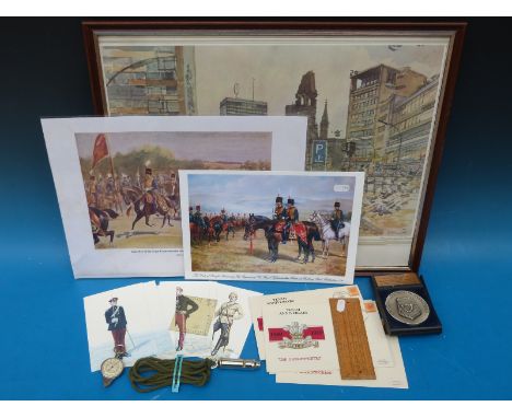


Lot 267
Baedeker (Karl). Handbook for Travellers, Central Italy (1893), Northern Italy (1899), Belgium and Holland (1885), Rhine (1886), an Antiquarian Travellers map of Spain and Portugal, and Harriet Martineau's Complete Guide to the English Lakes, red cloth binding, spine in poor condition, (6). Provenance: Ex Duddington Manor


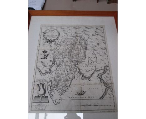
![John Bill, original hand-coloured map of 'Lincolneshire' [sic]. Framed.](https://cdn.globalauctionplatform.com/6a6ecd11-a9dd-40cc-ab46-a4ec0097ecc3/d336e2c3-1e35-44e4-9e0c-d3d884ea7614/468x382.jpg)


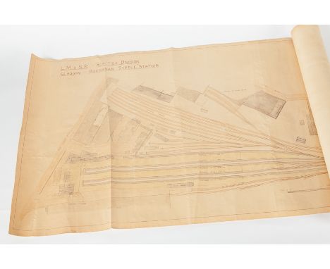
Lot 800
EARLY 20TH CENTURY RAILWAY STATION LAYOUT MAP OF BUCHANAN STREET STATION London, Midland & Scottish Railways Scottish Division track and platform full layout of Buchanan Street, Glasgow, scale of one inch to thirty three feet, printed onto thin fabric, rolled up in a cardboard sleeve, 56cm high x 167cm long


Lot 367
Thomas Kitchin (18th/19th Century - Two coloured engravings - "A New Map of Kent", 7.5ins x 9.5ins, and "Kent drawn fromm an actual survey and regulated by asronomical observations", 5.75ins x 8.75ins, printed for R. Baldwin for the London Magazine, Thomas Badeslade (fl. 1719-1745 and William Henry Toms" - Coloured engraving - "A May pf Kent from "Chrgraphia Britanniae", circa 1741, 5.5ins x 5.75ins, and an 18th Century engraving - "Map of Kent with distance tables", 4ins x 4ins, all framed and glazed

Lot 368
Antonio Zatta (18th Century) - Coloured engraving - "Provincia di Kent", 11.5ins x 11.75ins, Venice 1779, John Seller (1630-1697) - Engraving - "Kent", for his "Anglia Contracta", 4.75ins x 5.75ins, first published 1695, Thomas Hutchinson (18th Century) Engraving - "A correct map of the county of Kent", from "Geographia Magnae Brittania", 1748, 5.75ins x 6.5ins, and one other Kent map


Lot 450
FROISSART (JEAN), CHRONICLES OF ENGLAND, FRANCE, SPAIN AND ADJOINING COUNTRIES FROM THE LATTER PART OF THE REIGN OF EDWARD II..., with John Cary map entitled 'The March of King Edward 3rd through France; and fifty seven aquatint plates including Queen Isabella's arrival in Paris and Sir Oliver du Guesclin taken prisoner in the forest of Cherbourg, 3/4 leather with marbled boards, c1806 (1)
![CAMDEN (W), BRITANNIA SIVE FLORENTISSIMORUM REGORUM ANGLIAE SCOTIAE HIBERNIAE, [16], 831, [27], 30, engraved frontis half tit](https://cdn.globalauctionplatform.com/66c1d19d-e163-41d1-95f5-a4e100f7b273/c2d4de39-6120-4f0b-e01b-a422db33c025/468x382.jpg)
Lot 453
CAMDEN (W), BRITANNIA SIVE FLORENTISSIMORUM REGORUM ANGLIAE SCOTIAE HIBERNIAE, [16], 831, [27], 30, engraved frontis half title with map of Britain, engraved title, two folding maps of England and Wales, seven plates of coins, two engraved plates and map of Ireland, Londini Georg Bishop, 1600, possibly lacking 451/2, disbound, NOT SUBJECT TO RETURN


Lot 333
A box of assorted coins, together with folios of assorted bank notes, together with a World War II collection of bank notes, stamps, coins, etc, bound as one volume and two State Series Quarters 1990-2008 Collector map booklet containing American quarters, together with a "The Predecimals of Elizabeth II" gold plated cupro-nickel coin set, and a "The Emblem Series Decimals of Elizabeth II" gold plated cupro-nickel coin set


-
109198 item(s)/page