

River Thames. Palmer (Francis L.), To Accompany Mr. Palmer's Pamphlet on the Thames Floods, The Tower Bridge & to Illustrate the Tourist's Table. Map of the River Thames from its Source to the Sea, Ed. Stanford, [1877], colour lithographic map with two columns of text and a fanciful illustration of a proposed design for a new London Bridge, the text columns are headed 'Hail ! Smiling Morn' and 'Fishing', with a printed 'Birds-eye table' on the verso, old folds with small holes where folds cross, strengthened and repaired on verso, 290 x 460 mm, retains the contemporary blue cloth gilt slip case with the title 'Now Ready. Ordnance Map and Tourists' Table of the Thames by Francis L. Palmer..., for the Angler, Tourist and Boating Man. One Shilling', printed in gilt to upper cover, slip case size 85 x 125 mm, all contained in a modern cloth gilt portfolio by John Gardner, folio size 490 x 310 mm (Qty: 1)NOTESRare. There are no auction records for this map and we can only find two copies extant; one in the Guildhall Library and one in a private collection.
We found 109198 price guide item(s) matching your search
There are 109198 lots that match your search criteria. Subscribe now to get instant access to the full price guide service.
Click here to subscribe- List
- Grid
-
109198 item(s)/page

* Americas. Homann (Johann Baptiste, Heirs of), Americae Mappa Generalis Secundum Legitimas Projectionis Stereographicae Regulas ... Concinnata et Delineata ab Aug. Gott Boehmio Phil. Magistro. In Lucem Proferentibus Homannianis Heredibus A MDCCXXXXVI, [1746], engraved map with contemporary hand colouring, large uncoloured allegorical cartouche, slight dust soiling, 480 x 545 mm, mounted, framed and glazed (Qty: 1)
![Bible [English]. [The Holy Bible, conteyning the Old Testament and the New. Newly translated out of the originall tongues: an](https://cdn.globalauctionplatform.com/f18384cb-a82f-48dc-9fe9-aab801078ac9/c5fd2e6f-da37-456d-a73e-aab9011585c4/468x382.jpg)
Bible [English]. [The Holy Bible, conteyning the Old Testament and the New. Newly translated out of the originall tongues: and with the former translations diligently compared and revised..., Imprinted at London by Robert Barker, 1612], lacking general title, New Testament title present with decorative woodcut border, Apocrypha present, double-column roman type, bound with Genealogies at front (without map), early 18th century manuscript genealogical entries for Richard Reston and family to verso of New Testament title and early 19th century entries for the Dutton family to verso of list of Books in Bible, few leaves torn and frayed with slight loss, sewing weak and some pages sprung, some dust-soiling, occasional dampstaining and few marks, contemporary sheep, torn at head & foot with loss, board corners & edges worn and showing, 4to (Qty: 1)NOTESHerbert 313; Darlow & Moule 242; STC 2219. The first quarto edition of King James' version; printed in roman type. With Genesis x.16, Emorite ; Ruth iii.15, hee.
![Persia. Ortelius (Abraham), Persici sive Sophorum Regni Typus, [1612], engraved map with contemporary hand colouring, slight](https://cdn.globalauctionplatform.com/f18384cb-a82f-48dc-9fe9-aab801078ac9/e0dbbf7e-0e91-4250-b15a-aab90114f813/468x382.jpg)
Persia. Ortelius (Abraham), Persici sive Sophorum Regni Typus, [1612], engraved map with contemporary hand colouring, slight offsetting, some oxidisation to old watercolour causing slight cracking, 355 x 490 mm, Latin text on verso (Qty: 1)NOTESMarcel van den Broecke, Ortelius Atlas Maps, 167.

China. Dorn (Frank), A map and history of Peiping: formerly known as Peking..., 1st edition, Peiyang Press Ltd., Peiping, 1936, colour lithographic pictorial map of Peking, old folds strengthened on verso, supplied with publisher's paper slipcase, 820 x 720 mm (Qty: 1)NOTESA pictorial and illustrative map showing the principal sites and occupations of the inhabitants, within a border giving a pictographic introduction to Chinese history from 1100 B.C. to 1927. The whole map is crowded with amusing vignettes of the life and sights of Peking ranging from the Forbidden City and the Old Execution Ground through to Pigeon Thieves, the Eunuchs' Cemetery, the Dog Temple, the Temple of Eighteen Hells and the Spider Pagoda. Frank 'Pinky' Dorn was an American artist, 'old China hand,' and military officer. Born in 1901 in San Francisco, he studied at West Point from where he was commissioned into the Field Artillery. He served in the Philippines from 1926 to 1929 and became an instructor at the Field Artillery School from 1930 to 1933. He moved to Beijing in 1934 where he studied Chinese. In WW II he was an aide to Brigadier General 'Uncle Joe' Stilwell in Burma from 1939 - 1942. From 1944 to 1945 he was the commander of the China Training and Combat Command. He retired in 1953 with the rank of Brigadier General and returned to San Francisco where he devoted the remainder of his life to painting. Dorn died in 1981 and was buried with full military honors at Arlington National Cemetery.
![London. Stanford's Map of Modern London and the Suburbs, Edward Stanford, [1878], large engraved map with bright contemporary](https://cdn.globalauctionplatform.com/f18384cb-a82f-48dc-9fe9-aab801078ac9/9f0ae882-18e2-49cd-9637-aab90114f13d/468x382.jpg)
London. Stanford's Map of Modern London and the Suburbs, Edward Stanford, [1878], large engraved map with bright contemporary hand colouring, sectionalised and laid on linen, on four sheets, a few folds repaired on verso, overall size approximately 1875 x 1720 mm, contained in a modern cloth slipcase but retaining contemporary morocco gilt label to upper cover (Qty: 1)NOTESA large striking map of London.

British Isles. De Vaugondy (Gilles Robert), Carte des Grandes Routes D'Angleterre, D'Ecosse et D'Irlande, circa 1778, hand coloured engraved map, large decorative cartouche, some creasing, 480 x 585 mm, together with Wyld (J.). A Map of England, Wales & Scotland describing all the Direct and principal Cross Roads in Great Britain..., 1840, engraved map with contemporary outline colouring, inset map of Scotland, old folds, one repaired closed tear, 730 x 615 mm, with Chanlaire (P.G.). Carte des Isles Britanniques et des Côtes qui les avoisinent..., Paris, 1804, engraved map with contemporary hand colouring with a calendar of dates of fairs below map, 570 x 430 mm, plus Vicq (J. M.). Carte de L'Angleterre, de L'Ecosse et de L'Irlande..., Paris, 1808, engraved map with contemporary hand colouring, inset maps of Portugal and Gibraltar, slight staining, faint pencil line showing ferry routes, 540 x 515 mm, and Vivien (L.). Carte des Iles Britanniques..., Paris, 1834, engraved map with contemporary outline colouring and some later enhancement, 575 x 400 mm, with Blair (John). A Map of Great Britain and Ireland..., [1801], uncoloured engraved map, inset map of the Orkney and Shetland Islands, old folds, slight staining, 425 x 565 mm (Qty: 6)

![* British Isles. Blaeu (Guillaume), Magnae Britanniae et Hiberniae tabula, Amsterdam, [1631 or later], engraved map with cont](https://cdn.globalauctionplatform.com/f18384cb-a82f-48dc-9fe9-aab801078ac9/6822b0da-16bc-4932-aa41-aab90114dfbb/468x382.jpg)
* British Isles. Blaeu (Guillaume), Magnae Britanniae et Hiberniae tabula, Amsterdam, [1631 or later], engraved map with contemporary outline colouring, inset map of the Orkney Islands, slight spotting, 385 x 500 mm, mounted, framed and glazedNOTESR. W. Shirley. Early Printed Maps of the British Isles, 423.
![Bible [English]. The Holy Bible, Containing the Old Testament, and the New: Newly Translated out of the Originall Tongues...,](https://cdn.globalauctionplatform.com/f18384cb-a82f-48dc-9fe9-aab801078ac9/e5717eb6-5a5e-4af3-b1af-aab90115881b/468x382.jpg)
Bible [English]. The Holy Bible, Containing the Old Testament, and the New: Newly Translated out of the Originall Tongues..., Imprinted at London by Bonham Norton and John Bill, 1619, general title within decorative woodcut border (faint manuscript inscription to fore-edge margin, and date written below imprint date), double-column black letter text, Apocrypha present, without New Testament title, colophon with imprint for Robert Barker and dated 1620, bound with an incomplete genealogies by John Speed between list of 'Bookes of the Olde and New Testament' and first Book of Genesis (without double-page map to genealogies), numerous early manuscript inscriptions including prayers dated 1663 and ownership inscriptions 'Richard Eames is the Honour of his Book 1727', bound with an incomplete Concordance dated 1619, and Whole Booke of Psalmes, London: Company of Stationers, 1619, browning, dampstaining, dust-soiling and marks throughout, occasional worming mostly to margins, first and last leaves frayed and some tears, 19th century blind panelled brown morocco, large brass clasp, some wear to joints (with few worm holes), covers rubbed, scuffed & marked, 4to (leaf size 21.1 x 16.3cm), together with a defective early 17th century (1615?) black letter quarto Bible (Qty: 2)NOTESHerbert 374; Darlow & Moule 289; STC 2258. Text ends on 3S8a. The signature Hhh is omitted in this series. With 3G6b heading S. Matthew for S. Mark and corrected in manuscript in this copy.
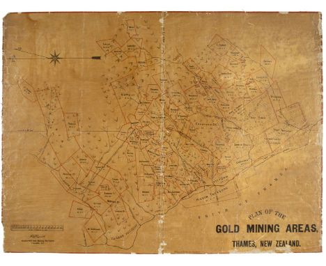
New Zealand. Plan of the Gold Mining Areas, Thames, New Zealand, Surveyor H. Kendrick, Auckland, Wilsons & Horton, circa 1886, lithographic map, some fraying and chipping to central fold and margins, occasional closed tears, laid on linen, some pencil annotations to verso, 500 x 660 mm, together Pollen (C. R., Surveyor). Auckland Sheet no. 3, NZ Lands and Survey, 1895, lithographic map with sparse outline colouring, partially sectionalised and laid on linen, some creasing and dust soiling, two long closed repaired tears affecting image, slight staining, 720 x 920 mm (Qty: 2)

United States. Blanchard (Rufus), Historical Map of the United States Showing Early Spanish, French and English Discoveries and Explorations, also Forts, Towns & Battlefields of Historic Interest, Chicago, 1876, large folding lithographic map, laid on linen, several inset maps including reproductions of early maps and historical views, table of explanation, introductory notes in margins, some fraying with slight loss where old folds cross, 1350 x 1460 mm, chronological tables fixed to verso of map, bound in contemporary morocco gilt boards, worn and cracked (Qty: 1)
![Blome (Richard). A collection of ten county maps. [1673], ten uncoloured engraved county maps, one map (Norfolk) with some st](https://cdn.globalauctionplatform.com/f18384cb-a82f-48dc-9fe9-aab801078ac9/570f5644-2384-44b3-afde-aab90114cc5a/468x382.jpg)
Blome (Richard). A collection of ten county maps. [1673], ten uncoloured engraved county maps, one map (Norfolk) with some staining, one map duplicated, each approximately 210 x 285 mmNOTESThe maps consist of :- East Riding of Yorkshire (2 copies) , West Riding of Yorkshire, North Riding of Yorkshire, Worcestershire, Warwickshire, Suffolk, Shropshire, Northumberland and Norfolk.
![Bible [English]. [The Holy Bible, conteining the Olde Testament and the Newe: of that Translation authorised to be read in Ch](https://cdn.globalauctionplatform.com/f18384cb-a82f-48dc-9fe9-aab801078ac9/60591ebe-8d7a-436c-a5af-aab901157c98/468x382.jpg)
Bible [English]. [The Holy Bible, conteining the Olde Testament and the Newe: of that Translation authorised to be read in Churches. Imprinted at London by Christopher Barker, 1584], titles to Psalter or Psalmes and New Testament present both with decorative woodcut borders, woodcut map to text , few decorative woodcut initials, head & tailpieces etc., double-column black letter text, Apocrypha present, without general title and lacking 7 other preliminary leaves at front and 19 leaves also lacking at rear (lacking 4A8 onwards at rear), also lacking D1-D8 (leaves numbered 25-32), lacking Q2 & 3A1 (leaves numbered 122 & 269), occasional early manuscript notes and marks, hole to 3I2 with text loss, numerous leaves in New Testament torn with loss & some with crude repairs, some marginal fraying and tears throughout, dust-soiled and marked, later endpapers, contemporary blind embossed calf over wooden boards, central brass boss to each board and one corner-piece present only, old reback, with few later repairs, lacking clasps, some wear, folio (leaf size 30 x 19.3cm) (Qty: 1)NOTESHerbert 185; Darlow & Moule 141; STC 2141. The Bishops’ version, the translation overseen by Matthew Parker.

Glamorganshire. Saxton (Christopher & Webb William), Glamorg? comitatus australis Cambriae pars descriptio, 1642, uncoloured engraved map, lower margin extended, 335 x 490 mm, mounted (Qty: 1)NOTESA rare 'civil war edition' of Christopher Saxton's map of Glamorgan by William Webb. The arms of Elizabeth I have been replaced by those of Charles I, and apart from the change to the date very few other alterations have been made. In very good condition.
![Bible [English]. The Holy Bible, Containing the Old Testament, and the New: Newly Translated out of the Originall Tongues, an](https://cdn.globalauctionplatform.com/f18384cb-a82f-48dc-9fe9-aab801078ac9/398edf5f-f0a4-4f5e-bc26-aab9011588d9/468x382.jpg)
Bible [English]. The Holy Bible, Containing the Old Testament, and the New: Newly Translated out of the Originall Tongues, and with the former Translations diligently compared and revised, By his Majesties speciall commandment, Imprinted at London by Bonham Norton and John Bill, 1625, general title within decorative woodcut border incorporating initials 'I.R.' at foot (early signature to verso of Wm Swannell), woodcut royal arms of James I to A2 with early ownership of Ann Swannell of Padbury, Apocrypha present with ink scribble at foot of final leaf, without New Testament title (3E3), double-column black letter text with occasional woodcut initials, head and tail pieces, colophon dated 1624, bound with at front a somewhat worn Booke of Common Prayer..., London: Bonham Norton & John Bill, 1621, initial leaves torn and some repaired, also bound with The Genealogies, by John Speed at front (without map), and bound with at rear Two Right Profitable and Fruitfull Concordances..., Collected by R.F.H., Imprinted at London by Bonham Norton and John Bill, 1622, final leaf of Concordances with colophon dated 1621 and inscribed 'Willm. Swannell His Book, Janry. the 16th 1765', also bound with an incomplete Book of Psalms, 1625, some leaves at rear loose and frayed to margins, general toning and dust-soiling throughout, few marks, without free endpapers, contemporary panelled sheep, old worn reback, binding worn, 4to (leaf size 21.4 x 15.5cm), together with a poor incomplete Holy Bible, Imprinted at London: Bonham Norton & John Bill, 1629, both titles present, New Testament incomplete at rear, text block split and some leaves torn and frayed, bound with an incomplete genealogies by John Speed at front, includes double-page woodcut map (torn with loss), browning, staining and dust-soiling throughout volume, old sheep, crude spine and cover repairs, text block broken, worn, 4to (Qty: 2)NOTESHerbert 395; Darlow & Moule 303; STC 2270.
![Scotland. Porcacchi ( Tomaso ), Isole Hebride et Orcade, [1713], uncoloured engraved map, Italian and French text above, belo](https://cdn.globalauctionplatform.com/f18384cb-a82f-48dc-9fe9-aab801078ac9/6de0089f-8a42-4e5e-adb5-aab90114fd02/468x382.jpg)
Scotland. Porcacchi ( Tomaso ), Isole Hebride et Orcade, [1713], uncoloured engraved map, Italian and French text above, below and on verso of map, dimensions of map 105 x 145 mm, together with Mallet (A. M.). Royaume D'Ecosse, [1686], uncoloured engraved map some fraying to left hand vertical margin with very slight loss to printed margin, 150 x 115 mm (Qty: 2)
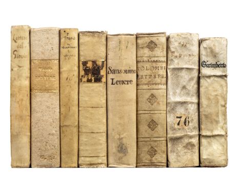
Giovio (Paolo). Lettere Volgari, raccolte per messer Lodovico Domenichi. Et nuovamente stampate con la tavola, 1st edition thus, Venice: Giovanni Battista and Melchior Sessa, 1560, toning, occasional finger-soiling and marginalia, contemporary limp vellum, slightly shaken, ties perished, 8vo (15.1 x 10 cm), together with: Tolomei (Claudio), Delle lettere libri VII. Con nuova aggiunta ristampati, e con somma diligenza da molti errori corretti, Venice: Altobello Salicato, 1572, woodcut map of the Monte Argentario peninsula in Tuscany to folio 190 verso, title-page and final quire browned, a few stains elsewhere, lacking final blank (P8), 18th-century vellum, 8vo (14.6 x 9.6 cm), Garimberto (Girolamo), Concetti ... raccolti dal lui per scriver e ragionar famigliarmente. Di nuovo con somma diligenza corretti, e ristampati, Venice: Nicolo Bevil'acqua, 1564, A-S12 T10 (T10 blank but for publisher's woodcut device verso), occasional damp-staining, 18th-century book-label (John Rutherfurd of Edgerston), front inner hinge split but holding, contemporary limp vellum, later manuscript spine-title, ties perished, 12mo (14 x 8 cm), Tasso (Bernardo), Li tre libri delle lettere. Alli quali nuovamente s'è aggiunto il quarto libro, Venice: P. Gironimo Giglio, 1559, a-ii8 kk2, light spotting and damp-staining, contemporary limp vellum, 8vo (14.2 x 9 cm), and 4 others (incomplete 16th-century editions of the letters of Tasso and Sansovino, vellum bindings, 8vo) (Qty: 8)NOTESProfessor Cecil H. Clough (1930-2017), Reader in Medieval History, University of Liverpool. Adams G697 (Giovio), T789 (Tolomei). Garimberto's Concetti were first printed in 1551; this edition is not in Adams and OCLC traces two copies world-wide.
![Bible [English]. The Holy Bible, Containing the Old Testament and the New. Newly translated out of the Originall Tongues: and](https://cdn.globalauctionplatform.com/f18384cb-a82f-48dc-9fe9-aab801078ac9/4fe9b681-b09b-4f2c-b353-aab901158b0e/468x382.jpg)
Bible [English]. The Holy Bible, Containing the Old Testament and the New. Newly translated out of the Originall Tongues: and with the former Translations diligently compared and revised, by his Majesties speciall commandement, London: Printed by Robert Barker, and by the Assignes of John Bill, 1634, general and New Testament titles present, both within decorative woodcut borders (NT title with imprint dated 1636), Apocrypha present, double-column black letter text, colophon dated 1634, some close trimming to margins with consequent cropping to marginal notes, with genealogies by John Speed and double-page woodcut map, genealogies title and few other leaves with tissue repairs, toning and dust-soiling throughout, occasional spotting, 20th century blind panelled and decorated dark brown morocco, 4to (leaf size 21.8 x 16.2cm) (Qty: 1)NOTESHerbert 490; Darlow & Moule 379; STC 2313b. Provenance: From the collection of Captain Sir Charles Robert Bignold (1892-1970), a member of the prosperous Bignold family of Norwich. His ancestor Thomas had established the Norwich Union Insurance Company in 1797. Charles Robert Bignold was a distinguished collector of fine books and the auction sale of his collection was conducted by Sotheby’s in 1971. This bible contains Bignold family genealogies in manuscript to additional leaves bound-in at the rear of the volume.

* West Indies. Homann (Johann Baptiste, Heirs of), Mappa Geographica, Complectens I. Indiae Occidentalis Partem Mediam Circum Isthmum Panamensem II. Ipsumq. Isthmum III. Ichnographiam Praecipuorum Locorum & Portuum..., Nuremberg, circa 1740, engraved map of the Gulf of Mexico and the West Indies with contemporary outline colouring, inset maps of the Isthmus of Panama, St. Augustine, San Domingo and Vera Cruz, inset view of Mexico City, slight creasing and dust soiling, 580 x 490 mm, mounted, framed and glazed (Qty: 1)
![Bible [English]. The Bible, that is, the Holy Scriptures conteined in the Olde and Newe Testament, Translated according to th](https://cdn.globalauctionplatform.com/f18384cb-a82f-48dc-9fe9-aab801078ac9/67755bb9-7375-459f-bbf1-aab901157fe5/468x382.jpg)
Bible [English]. The Bible, that is, the Holy Scriptures conteined in the Olde and Newe Testament, Translated according to the Ebrew and Greeke, and conferred with the best Translations in divers Languages..., Imprinted at London [i.e. Amsterdam]: by the Deputies of Christopher Barker, 1599 [i.e. circa 1599-1640], general title present with woodcut border (imprint dated 1599), letterpress general title with woodcut illustration, New Testament title within decorative woodcut border, few woodcut illustrations and decorative initials, double-column roman type, bound with Apocrypha lacking one leaf of 1 Esdras, blank after Old Testament, colophon at end of Tables dated 1599, occasional marginal fraying & tears (mostly to few leaves in Apocrypha), bound with an incomplete Common Prayer at front and Genealogies by John Speed with double-page woodcut map (marked and dust-soiled), also bound with a Book of Psalms at rear, general toning and some marginal browning, dust and finger-soiling, occasional damp-stains, few marks and spots etc. throughout volume, early/mid 19th century dark green straight grain morocco, blind panelled decoration to boards and spine, upper board detached, extremities worn, 4to (Qty: 1)NOTESHerbert 251; Darlow & Moule 190; STC 2176. Geneva version; with Thomson's NT, but with Junius' Revelation. With Esther i:1 '...seven and / twenty provinces'. Headline Ee3b corrected to ' Proverbes'. Many of the previous errors are corrected. This example also omitting line in Eccles. iv.9 as the previous 3 issues of the same version, Two are better [than one: for they have better] wages for their labour . These Bibles were printed probably in Amsterdam and Dort and adopted by Barker, for the use of English Puritans in the Low Countries. There are many editions bearing this date, which while agreeing closely are yet distinct. No doubt a certain number of copies were originally issued in a mixed state. The nominal date, 1599, is probably untrue in almost every case.

British Isles. Homann (Johann Baptiste, Heirs of), Magna Britannia complectens Angliae, Scotiae et Hyberniae..., circa 1730, engraved map with contemporary hand colouring and some later enhancement, inset map of the Shetland and Orkney Islands, some dust soiling, 500 x 575 mm, together with Moll (Herman). A chart of the Sea Coast of Great Britain and Ireland, circa 1720, hand coloured engraved map, 345 x 280 mm, with Sayer (Robert, publisher). A Compleat Map of the British Isles, or Great Britain and Ireland with their respective Roads and Divisions, 1772, engraved map with contemporary outline colouring, 625 x 485 mm, plus De L'Isle (Guillaume). Les Isles Britanniques ou sont le Rme. Angleterre tiré de Sped celuy d'Ecosse tiré de Th. Pont &c. et celuy d'Irlande tiré de Petti..., Paris, 1772, engraved map with contemporary outline colouring, central fold split with strengthening to verso, 480 x 620 mm (Qty: 4)
Wiltshire. Andrews (John & Dury Andrew), A Topographical Map of Wiltshire on a Scale of 2 inches to a mile from an Actual Survey by John Andrews & Andrew Dury in the year 1773, 1st edition, 1773, edition, published 1773, large scale engraved map on eighteen sheets (complete) all with contemporary outline colouring, large uncoloured cartouche, some marginal dust and finger soiling, slight staining and spotting, bound with the index map, 'A Map of Wiltshire (Taken from and Actual Survey) being the Index to the large one', the index map has some spotting, creasing and dust soiling and is frayed and torn with slight loss along the lower margin, later endpapers, late 19th century half calf gilf, some wear to extremities, slim folio (Qty: 1)

Scotland. Elphinstone (John), A New & Correct Mercator's Map of North Britain, Carefully Laid down from the Latest Surveys and Most Approved Observations, printed for A. Millar, March 6th 1745, engraved map with contemporary outline colouring, engraved by Thomas Kitchin, inset map of the Shetland Islands, large black & white martial cartouche and separate dedication cartouche to William Duke of Cumberland, old folds, slight browning and spotting, partially split along old fold, large margins, 680 x 540 mm, together with another copy similar, but trimmed to neat line with some creasing and fraying to image, 675 x 535 mm (Qty: 2)NOTESDuring the Jacobite Rising, the English forces, led by George II’s son, William, Duke of Cumberland pursued Bonnie Prince Charlie's army back across the Scottish border. They arrived at Edinburgh at the end of January 1746, and then ventured north to Aberdeen. The Jacobites fled further north, but Cumberland was in no mood to hurry after them. He was acutely aware of the difficulty of moving troops through the Highland terrain, where roads were few and opportunities for ambush many. The most up-to-date map of Scotland available to both the English and the Jacobite sides was this map by John Elphinstone, a military engineer who served with the Duke of Cumberland's army. Though it was drawn in 1745, and was a great improvement on earlier maps, it nonetheless attracted criticism for its inaccuracies. Elphinstone's depiction of hills, for example, is entirely schematic with none of the detail necessary to thread a route between Highland glens or plan military offensives.

Perry (John). The State of Russia, under the present Czar. In relation to the several great and remarkable things he has done, as to his naval preparations, the regulating his army, reforming his people, and improvement of his countrey..., also an account of those tartars..., to which is annex'd, a more accurate map of the Tsar's dominions, than has hitherto been extant, 1st edition, Benjamin Tooke, 1716, folding engraved map by Herman Moll (spotting and offsetting, short split to inner margin, some spotting and browning to text, old ownerships signature of J. Foley to title, contemporary panelled calf, somewhere, upper cover detached, 8vo (Qty: 1)
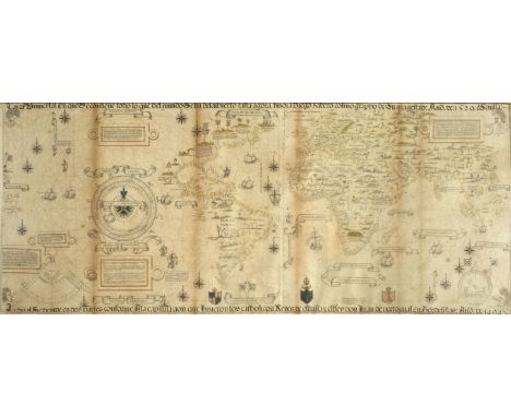
* World. Ribero (Diego), Carta Universal en que Se contiene todo lo que del mondo Se ha descubierto fasta agora:hizola Diego Ribero cosmographo de Su magestad: Año de 1529. ? Sevilla: La qual Se devide endos partes conforme A la capitulacion que hizieron los catholicos Reyes de españa, y elrrey donJuan de portogual En Tordesillas: Año de 1494: published 1529 [but 1887 copy by W. R. Griggs], photo-chromolithographic colour printed copy of the known world on two conjoined sheets, some light staining, 580 x 1390 mm, framed and glazed (Qty: 1)NOTESA scarce later copy of the Propaganda or Second Borgian map, now in the Biblioteca Apostolica Vaticana, Vatican City. Diego Ribero was regarded as the finest cartographer of his day and this magnificent map was produced for the kings of Spain and Portugal. The translation of some of the notes on the map reveal its imperial and economic nature. For example on the coast of Greenland is a note stating 'The English discovered this country. It produces nothing of any value. It was discovered by the English from the city of Bristol.' - a nod to the voyage of John Cabot - and on Newfoundland it states 'The land of cod fish discovered by the Corte Reals and where they were lost. Up to this time nothing of value has been found there, except the fishing of codfish, and these do not amount to much'. These comments and the sometimes spurious accreditation of discoveries to Spanish and Portuguese explorers gave rise to the map being referred to as 'The Propaganda Map'.
![* Americas. Munster (Sebastian), Americae Sive Novi Orbis Nova Descriptio, Basle, [1588-1628], hand coloured wood block map o](https://cdn.globalauctionplatform.com/f18384cb-a82f-48dc-9fe9-aab801078ac9/538dffac-8093-45ca-b604-aab90114c8a2/468x382.jpg)
* Americas. Munster (Sebastian), Americae Sive Novi Orbis Nova Descriptio, Basle, [1588-1628], hand coloured wood block map of north and south America, old fold, short closed tear in upper margin, repaired on verso, 305 x 365 mm, framed and double glazed, German text on verso (Qty: 1)NOTESPhilip Burden, The Mapping of North America, 67.
![Bible [English]. The Holy Bible, Containing the Old Testament and the New. Newly translated out of the originall tongues...,](https://cdn.globalauctionplatform.com/f18384cb-a82f-48dc-9fe9-aab801078ac9/3e58bd1b-f463-4069-910d-aab901158c58/468x382.jpg)
Bible [English]. The Holy Bible, Containing the Old Testament and the New. Newly translated out of the originall tongues..., London: Printed by Robert Barker, and by the Assignes of John Bill, 1634, general and New Testament titles within decorative woodcut border (general title torn to upper outer corner with loss and lined to verso), Apocrypha present, double-column black letter text, some dust-soiling, toning and few marks, marbled endpapers with old adhesive tape to hinges, 19th century half calf, joints split and some wear, 4to (leaf size 22.8 x 16.5cm), together with The Holy Bible Containing the Old Testament and the New: Newly translated out of the originall Tongues..., Printed by the Printers to the Universitie of Cambridge, 1637, general and New Testament titles within typographic ornament borders (both with early manuscript entries and markings to verso, general title with ink burn hole and show-through staining), Apocrypha present and with early inscription to final leaf, double-column black letter text, lacking 2D2 & 2E8, leaves 3E3, 3K2 & 3K3 torn with loss, few other minor tears, dust- & finger-soiled throughout, some spotting, marks and stains, 20th century marbled endpapers, late 18th century panelled sheep, rebacked, board edges and corners worn and showing, 4to (leaf size 22 x 17cm) (Qty: 2)NOTESHerbert 502; Darlow & Moule 390. General title dated 1634; New Testament dated 1636 on title, but 1634 in colophon. This example bound without Genealogies and Concordance. Herbert 514; Darlow & Moule 397; STC 2326. This example bound without Genealogies & map.

Grose (Francis). The Antiquities of England and Wales , 8 volumes, Second Edition, Corrected and Enlarged, London: Printed for S. Hooper, 1783-1787, engraved titles to each, 51 engraved county maps after John Seller (volume 7 lacking Denbighshire), all with contemporary h and -colouring (some offsetting), and approximately 625 engraved plates & plans (few folding), plus one large folding engraved map (a few closed tears), hand-coloured in outline, majority of tissue guards to plates present, occasional spotting, volume 3 with lower blank portion of Tt3 excised, contemporary calf, gilt decorated spines with title and volume number labels, (four of the latter lacking), most joints cracking, worn 4to, together with Cordiner (Rev. Charles) , Remarkable Ruins, and Romantic Prospects, of North Britain, with Ancient Monuments and Singular Subjects of Natural History, 1788 , engraved frontispiece, engraved vignette title, 97 engraved plates, occasional mainly marginal spotting, final three plates with dampstain to fore-margins, free endpapers with early ink annotations, contemporary half calf, worn, 4to (Qty: 9)NOTESAntiquities: plate counts for this work seem to vary. This copy appears to lack a few plates or plans as listed, but has additional ones not mentioned. Volume 2 has an additional engraved country map for the Isle of Wight, not listed.

Three Boer War late 19thC commemorative handkerchiefs, decorated with sheet music for The Absent Minded Beggar, by Arthur Sullivan, portraits of Her Majesty Queen Victoria and Field Marshall Lord Roberts, map of the South African Republic and When You Shouted Rule Britannia by Rudyard Kipling, largest 46cm x 47.5cm.


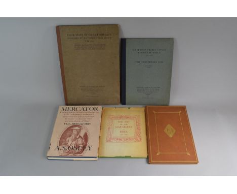
A Collection of Five Books Relating to Maps, Travel, Calligraphy and Palaeography To Include a 1928 Edition of Four Maps of Great Britain Designed by Mathew Paris About A.D 1250, a 1969 Edition of Mercator by A.S. Osley, A 1948 Edition of The Art of The Map-Maker in Essex 1566-1860, A 1972 Edition of John Norden's Manuscript Maps of Cornwall and its Nine Hundreds and a 1931 Edition of Sir Francis Drake's Voyage Round the World
1- Jones' Views of the Seats Mansions Castles in England Illustrated. Two series/volumes bound in four. Jones & Co. 1829. With 2 Engraved title pages with a view to each Plus 194 Plates, each plate with two views. Half leather, rebacked with new spines and endpapers. Occasional foxing ; 2- Blellington, Countess; Bayly, Thomas Haynes: Gems of beauty displayed in a series of 12 highly finished engravings. Longman, 1840; Bound With : Flowers of Loveliness; Twelve Groups of Female Figures. Ackermann, 1837. With 12 engraved plates Plus engraved title. Folio, Original full leather with blind and gilt decoration and aeg; 3- scrap album with 61 Engraved plates of British Coastal Scenes, mostly dated 1841 ; 4- Carne, J: Syria, The Holy Land & Asia Minor Illustrated. Vol. 3 only. Fisher, (1838). With vignette title, Map plus 45 engraved plates. 4to. Damp stain to last plate (7)
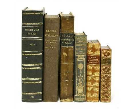
1- Ross, Sir John: Narrative of a Second Voyage in Search of a North-West Passage.. Webster, 1835, Large 4to. With 30 charts & Plates (9 hand coloured). Later ¾ leather with new endpapers. The odd small stain ; 2- Mac Farlane, C: JAPAN An Account Geographical & Historical. Routledge, 1852. With a frontis folding map and illustrations. Original gilt pictorial cloth; stain to ½ title and verso of frontis; 3- Report of the International Polar Expedition to Point Barrow, Alaska,. Washington, 1885. Large 4to. with a folding map and 20 plates (3 coloured). Original cloth; 4- JOURNAL OF COMMODORE GOODENOUGH during his last Command as Senior Officer on the Australian Station. H S King, 1876, 1st edn. PP:xi, 369, Plus three large folding linen backed charts. Half leather, rubbed ; Plus two others: The U. S. Naval Astronomical Expedition.. vol. 1 Chile. 1855; And Bird’s Unbeaten Tracks in Japan (6)
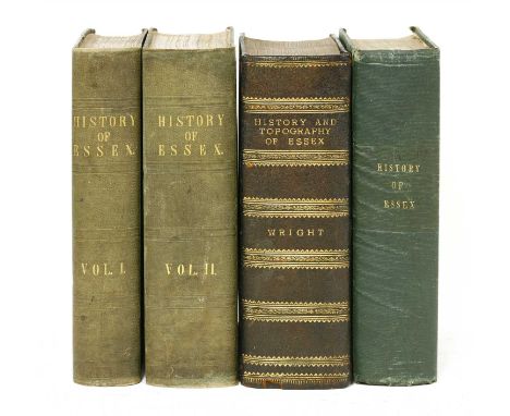
Wright, Thomas: Various edition of: The History And Topography of the County of Essex, in 2 vols. Virtue, 1836; (the general engraved title pages are dated: 1842 & 1834), two volumes. With two extra engraved title, colour map plus 98 of 100 plates ( lacking two plates); Plus: Part set in one vol. : Virtue, March 1, 1831. PP:683; 306(only), Plus Frontis, Engraved title and 48 Plates in vol.1 and 19 Plates in vol. 2 and No title. Half leather; Plus: Part set in one vol. : Virtue, March 1, 1831. PP:683; 148(only), Plus Frontis, Engraved title and 54 Plates in all bound at the end of the volume. Two plates trimmed and one with stain; occasinal foxing. A/F (4)
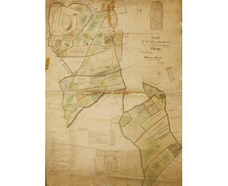
IRISH INTEREST: Original Hand drawn and coloured MAP of the Estate of Miss. E. Flood, situated in the liberties of the City of KILKENNY. Containing plantation measure surveyed in 1839, laid down by a scale of ten perches to an inch. 106 x 76cm. Linen backed in two sections, joined together and rolled. Few small tears.
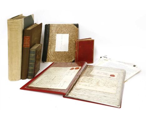
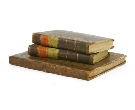
Hardwick: 1- Cullum, Sir Thomas-Gery: History and Antiquities of Hawsted and Hardwick in the County of Suffolk. J. Nichols, 1813, 2nd. edn. Complete with a portrait frontis, 10 plates plus 6 pedigrees. 4to. later cloth backed boards; rubbed; 2- Farrer, Rev. E: Portraits In Suffolk Houses (West). Quaritch, 1908, Limited edition, number 95 of 100 large paper copies. Cloth backed boards; rubbed and inner hinges cracked ; 3- Starke, M: Travels in Europe. Paris, Galignani, 1836, 9th. edn. with a large folding Map & a plan. Cont. half leather; rubbed; map torn (without loss) ; 4- An eighteenth century manuscript notebook, 70pp bound in cont. full leather; 5- John Flood: his will, dated May 1761; a lease between Henry Flood and Rich. Rice, August 1700; Plus various other documents; 6- Folder of other papers, including a printed silk fabric with red border: 'May it please your Majesty' From William Lloyd Flood (the High Sheriff) and Grand Jury of the County of Kilkenny, Ireland- on the occasion of the Royal visit (6)
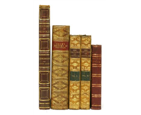
SUFFOLK: Gage, John: 1- The History and Antiquities of Suffolk Thingoe Hundred. John Deck, Bury St Edmunds, 1838, 1st. Edn. PP:xxvii, (I), 538. With hand-coloured Engraved map and 33 other plates & maps. Cont. full calf; rubbed, book plates of William Dunn Gardner to front pastedown and of Francis A Brooks to front endpaper. Foxing to some of the plates ; 2- The History and Antiquities of Hengrave in Suffolk. J Carpenter, 1822, large paper copy. With 30 plates & tables (3 double-page), one hand-coloured and several hand-tinted. PP:vii, (I), 263. Folio, Cont. full morocco with gilt lettering to spine and teg. Covers rubbed & with a couple of cuts; some foxing ; 3- Hervey, W: The Visitation of Suffolk, 2 volumes, Large Paper set. Lowestoft, S Tymms, 1866. With plates and illustrations. Cont. half leather, rubbed and hinges cracked ; 4- Clarke, G. R: The History & Description of the Town and Borough of Ipswich. Ipswich, S. Piper, nd, (1830) preface and plates dated 1830. Large pager copy with a list of subscribers. PP:(xviii), 504, plus Engrave title page and 20 plates. Cont. half leather; rubbed (5)
1- Gmelin, Carl Christian: Gemeinnützige systematische Naturgeschichte fur Gebildete Leser. Pt. 4; Der FISCHE Two Volumes- text & Plate volumes. With 164 hand coloured illustrations on 113 Plates , Complete. Mannheim, 1818. PP: Vol.1- x(including blank endpaper, no ½ title), (x), 383, (i), xxiv); Vol.2- 113 plates plus one endpaper; no title page to volume 2 and lacking the front blank endpaper. Near cont. leather backed boards; rubbed; clean plates; 2- HOGREWE, J. L: Beschreibung der in England seit 1759. angelegten und jetzt grössentheils vollendeten schiffbaren Kanaele.. (Description of the navigable canals, which have been constructed in England since 1759 and are now largely completed,.). Hannover, Pockwitz, 1780. 4to. PP(xii), iv, (ii), 164, (i), Plus folding hand coloured Map And 9 folding hand coloured plates. Leather backed speckled boards; rubbed; some foxing. (3)
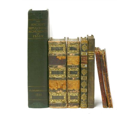
ESSEX: 1- Chancellor, F: The Ancient Sepulchral Monuments of Essex. 1890; 2- Ogborne, E: The History of Essex. Printed for the proprietors and sold by R H Kelham, Chelmsford, etc.. 1814. 4to. 280pp. Lacking the frontis , all other plates and illustrations present. Original blind stamped cloth, recased with new endpapers. 3- Wright, T: The History And Topography of the County of Essex, in 2 vols . Virtue, Vol.1- 1835. PP:696(including index), Plus: Engraved title page, Large folding Map, and 35 Plates; Vol.2- 1831, PP:836(including index and list of plates), Plus: Frontis, Engraved title, And 63 Plates, Complete. Cont. half leather, rubbed. A couple of pages trimmed; occasional foxing ; 4- Wright, T: Virtue's Picturesque Beauties of Great Britain. County of Essex. 1834. 4to. PP:Extra engraved title, iv, 96, Plus 48 plates each with two views, making 96 in all out of 105 views ( lacking the frontis plus 8 views ). Cont. half leather; rubbed. Lacking front endpaper occasional foxing ; Plus: 2 large folding linen backed Essex County Council Road Maps of Essex, c1906. Tears to folds (7)

Astronomy: 1- Reynolds, John; Drawn and Engraved by John Emslie: Diagrams illustrating the sciences of Astronomy and Geography. J. Reynolds, 1844-46, 1st. A COLLECTION OF 8 OUT OF 12 PRINTS: The Theory of the Seasons . Drawn and Engraved by John Emslie 1844 (coloured); Transparent Solar System . J. Reynolds N.d. with coloured tissue paper backing; Telescopic Appearance of the Moon. blacks and greys; Eclipses [and] The Theory of the Tides , (coloured); Geographical Diagram of the Earth Adapted for Illustrating its Movements, 2 volvelles; Diagram of Meteorology ..(coloured); Waterfalls. (coloured); Transparent diagram of the Phases of the Moon . tissue paper backing and holes in the card. All 8 are loosely enclosed in gilt lettered blind embossed cloth covers, with the printed explanations pasted to both covers pastedowns; 2- Blaikie, W B: Monthly Star Maps for 1916, 19th. Series. Edinburgh, Scottish Provident Institution, 1916. With 2 colour ills. for each month, plus a double page Map of the Heavens in Hemispheres (2)

Braybrooke, Richard Lord: History of Audley End. To Which are Appended Notices of the Town and Parish of Saffron Walden in the County of Essex. Samuel Bentley, 1836. Folio, PP:xiv, 331, (I), with 20 Plates including the extra engraved title page, one Map and two Plans; PLUS 36 Coats of Arms hand painted by the Jermyn Pratt of Ryston hall (Downham Market, Norfolk), with his armorial bookplate to front and rear pastedown, Plus a handwritten list and a drawing tipped into the front blank endpaper. Cont. full morocco with gilt decoration to covers and spine, gilt inner dentelles and aeg. Covers rubbed; foxing to some of the plates.

Emmanuel Bowen, 'An Accurate Map of the County of Essex, divided into hundreds...with Historical Extracts Relatvie to Natural Produce, Trade and Manufactures...', by John Gibson, c.1780, hand-coloured outlines and an ornamental cartouche with figures and produce, 40 x 50cm, and Thomas Kitchin, 'County of Hartford', late 18th century, with coloured highlights and decorative cartouches, 54 x 65cm (2)

1- Morant, Philip: The History And Antiquities of the County of Essex, 2 vols. T. Osborne; etc. 1768. In two volumes. Folio, PP:xxviii, (iv), 195, 28, 519, (I)list of plates; Title page, (i)blank, vi, 646, Plus 32 Maps and plates (some folding). Cont. full leather with later spine. A couple of the plates laid down on card and strengthened; two pages creased and one with small tear; few ink notes in the margins ; 2- Morant, Philip: The History And Antiquities Of The Most Ancient Town And Borough Of Colchester. T Osborne, 1768, 2nd. Edn. improved. Folio, PP:Title, iv(including subscribers list), 195, 28(index), Plus: Frontis, folding Map, And 13 Plates (3 extra plates). Cont. full calf, rebacked with the original spine. The two coin plates have been trimmed and laid down ; 3- [Strutt, Joseph]: History and Description of Colchester.. In 2 vols. Colchester, W Keymer, 1803, 1st. Edn. PP:title, 276, 22(appendix); [iv], 232, 4(index); Plus 6 Engraved Plates. Later leather backed marbled boards with new endpapers. Some gatherings are trimmed; occasional foxing ; Plus 3 others on Colchester: Colchester War Memorial Souvenir; The Great War. 1923; Colchester Worthies . (inscription dated 1893); Colchester Castle . 1882 (8)
Sale Catalogues: 1- Forster, H R: The Stowe Catalogue, Priced and Annotated. Bogue, 1848. Leather backed boards; 2- Catalogue of the nineteen Days Sale at Stowe, Near Buckingham. Jackson, Stops, 1921. 232 pages plus 4 coloured plans (2 folding), a location map and 56 plates; bound in the original printed paper-covered boards and quarter cloth. The catalogue of the sale starting July 4th 1921. The sale consisted of 3955 lots, with lot 1 being the mansion and grounds and lot 3955 two dozen bottles of Pale sherry; 3- Sir Lawrence Alma-Tadema's world famous home, the Freehold Sale particulars: Hampton & Sons, 1912. PP:28, (ii)wrappers. Illustrated with 21 photographs; 4- Purchasers' Catalogue of the Valuable Contents of Culloden House Sold at Auction By Messrs A. Fraser & Co. Wednesday, 21st. July, 1897. Numerous plates. PP:57+blank pages. Bound in the original leather backed tartan cloth covered boards; worn and torn ; 5- Christie & Manson Bernal: Catalogue of the Works of Art Collected by the late Ralph Bernal. 1855. 1st. PP:387, Plus 34 plates. Original cloth, recased; 6- Christie, Manson & Woods: Miniatures the Property of J. Pierpont Morgan, 1935. PP:272. Recent plain cloth (6)
-
109198 item(s)/page