We found 109182 price guide item(s) matching your search
There are 109182 lots that match your search criteria. Subscribe now to get instant access to the full price guide service.
Click here to subscribe- List
- Grid
-
109182 item(s)/page


Lot 1315
EUROPEAN BOXING CHAMPIONSHIPS 1953 A hardback Press folder including on the inside covers a map of Poland and a poster for the Tournament. Inside are a number of envelops and a writing pad with the Tournament logo. The programme with some results entered. A certificate presented to Whiting as a journalist. Plus his Tournament Press Card, his meal voucher book and other official documents. Good
![America.- [Beresford (William)] A Voyage round the World; but more particularly to the North-West Coast of America, performed](https://cdn.globalauctionplatform.com/3bbf975b-3c75-4453-96c4-abe400e2508e/8521e0ff-d0eb-45cb-838b-abe400f191d3/468x382.jpg)
Lot 1
America.- [Beresford (William)] A Voyage round the World; but more particularly to the North-West Coast of America, performed in 1785, 1786, 1787, and 1788...Captains Portlock and Dixon, first edition, half-title, 21 engraved maps and plates including sheet of engraved music and some of natural history, some folding, all but music with delicate hand-colouring, folding plate of dish and daggers lacking folding part, title lightly soiled and with signature cut away at head, some plates foxed, large folding map soiled and torn (repaired), some tears to other maps repaired, contemporary calf, gilt, rubbed and marked, edges worn, rebacked preserving old spine, new green morocco label, [Hill 117; Sabin 20364], 4to, 1789. ⁂ A series of letters written by William Beresford, cargo-officer on Dixon's ship the Queen Charlotte. Portlock and Dixon's voyage was the first commercial voyage to the Pacific North-West, ostensibly to set up a fur-trading business. They succeeded, however, in a more detailed exploration and mapping of the coast, visiting both the Falkland islands and Sandwich islands (Hawaii), and improved on Cook's charts of the region. Their two ships separated and sailed independently for most of the expedition, Dixon sailing south to Nootka Sound and Portlock, who had accompanied Cook on his third voyage, exploring north along the Alaskan coast (see following lot).
![Ptolomaeus (Claudius) Cosmographia, first edition, collation: aa10, bb8-1, a10, b-g8, h10, A-F8, G10. 142 of [143] leaves, la](https://cdn.globalauctionplatform.com/3bbf975b-3c75-4453-96c4-abe400e2508e/94db5aeb-24ca-446a-b05e-abe400f00afa/468x382.jpg)
Lot 111
Ptolomaeus (Claudius) Cosmographia, first edition, collation: aa10, bb8-1, a10, b-g8, h10, A-F8, G10. 142 of [143] leaves, lacking fol. aa1 blank. text in single column, 39 lines, type: 102R, finely hand-painted initials alternately in red or blue, that on aa8 verso with extension, seven-line blank space on aa1 recto, rubricated in red and blue, capital letters touched with yellow, 4 woodcut diagrams, two small wormholes to blank outer margin of first leaf repaired, without any loss, occasional light foxing, front and rear flyleaves both reinforced at an early date with a fragment from a manuscript, pencilled bibliographical notes on rear pastedown, contemporary wooden boards, one (of two) original oyster clasps preserved, spine covered in calf, with three raised bands, a few wormholes to covers, loss to top corner of upper cover, head and foot of joints slightly worn, preserved in suede-lined black morocco drop-back box by Boichot, folio (304 x 205mm.), Vicenza, Hermann Liechtenstein, 13 September 1475.⁂ An exceptional, and unsophisticated copy, with wide margins of the first edition of the most celebrated geographical treatise of classical antiquity. An edition of the greatest rarity, and a monumental achievement of geographical knowledge and a cornerstone of the European tradition. The Latin Ptolemy of 1475 was issued from the printing house established in Vicenza by the German printer Hermann Liechtenstein, also known by his surname 'Leuilapis'. A native of Cologne, he began his career as a printer in Vicenza, publishing the undated Historiae by Orosius in 1475, as well as the first edition of Ptolemy, completed on 13 September. Ptolemy's Geographia is one of the first books ever printed in Vicenza, where printing was first introduced in the spring of 1474 by Leonardus Achates de Basilea. The present work, divided into eight books, was produced by Ptolemy in the second century AD and describes the known inhabited world (or oikoumene), divided into three continents: Europe, Libye (or Africa), and Asia. Book i provides details for drawing a world map with two different projections (one with linear and the other with curved meridians), while Books ii-vii list the longitude and latitude of some 8,000 locations, Book vii concludes with instructions for a perspectival representation of a globe. In Book viii Ptolemy breaks down the world map into twenty-six smaller areas and provides useful descriptions for cartographers. The work was brought to Italy from Constantinople around 1400, and its translation into Latin was made by Jacopo Angeli (or Angelo da Scarperia) in Florence between 1406 and 1409. He was a pupil of Manuel Chrysoloras (ca. 1350-1415), the exiled Byzanthine scholar who had possibly begun the translation himself, on the basis of a hitherto unidentified Greek manuscript. Angelo's translation is mainly based on a composite text deriving from two different manuscripts. This volume was edited by Angelus Vadius and Barnabas Picardus and contains only the text of Ptolemy's Geographia. No maps were issued in this first edition of 1475, which were probably not present in the manuscript which served as copy-text, and the only illustrations included are the three diagrams in chapter xxiv of Book i (fols. bb5v, bb6v, and bb7v), showing the 'modus designandi in tabula plana', and that on fol. F3, depicting the Polus antarcticus. The first illustrated edition of Ptolemy appeared in Bologna in 1477, under the title of Cosmographia and supplemented with copperplates drawn and engraved by the famous illuminator Taddeo Crivelli. The Latin edition of this landmark geographical text enjoyed wide and enduring popularity. The editio princeps in Greek appeared in Basel only in 1533, and the circulation of the Latin text throughout Europe in the fifteenth century greatly influenced (both directly and indirectly) the shaping of the modern world. As Angeli writes at the end of his dedication: "Now, I repeat now, let us listen to Ptolemy himself speaking in Latin". Literature: HC 13536*; GW M36388; BMC vii, 1035; IGI 8180; Goff P-108; Flodr Ptolomaeus, 1; Sander 5973.Provenance: French bookseller's typed description to front pastedown.
Lot 15
South Seas.- Burney (Capt. James) A Chronological History of the Discoveries in the South Sea or Pacific Ocean, 5 vol., first edition, 28 engraved maps, 15 folding, and 13 plates, one folding, a few woodcut illustrations in text, vol.2 & 3 with final blank, some light spotting or soiling, more concentrated foxing to one or two gatherings, ex-library copy with perforated stamps to titles & maps and one or two other leaves, ink stamp to plates, ink reference number or code to foot of titles and final leaf, map at beginning of vol.2 soiled and torn with slight loss (repaired), handsome modern calf with leafy border in blind, spines gilt with red morocco labels, a few minor scuffs, [Hill 221; Sabin 9387], 4to, 1803-17.⁂ Account of all the voyages to the South Seas by Europeans, from the earliest navigators to Sir Francis Drake. James Burney was the brother of the novelist Fanny Burney, a lieutenant on Cook's second and third voyages, who gave his name to Burney's Beach in Queen Charlotte Sound, New Zealand.
Lot 16
South Seas.- Byron (Capt. George Anson, Lord) Voyage of H.M.S. Blonde to the Sandwich Islands in the Years 1824-1825, first edition, folding aquatint frontispiece of the Great Volcano of Peli, folding engraved map, 13 plates including plan, 3 engraved portraits, 8 fine aquatint views after Robert Dampier and wood-engraving, crease to frontispiece from previous fold, foxing, mostly to margins but sometimes heavier, tear to final 3 leaves repaired, modern morocco-backed boards, [Abbey, Travel 597; Hill 231; Sabin 100816], 4to, 1826.⁂ Account of the state visit of Kamehameha II of Hawaii and his queen, Kamamalu, to Britain in 1824 where they succumbed to measles and died, and the subsequent repatriation of their bodies to Hawaii by the British Government.

Lot 18
South Seas.- Labillardiere (Jacques Julien Houton de) Voyage in Search of La Pérouse, 2 vol., 2 engraved frontispieces, large folding map and 43 plates, titles with contemporary ink inscription "F.Beaufort 1805" at head and browned, title to vol.1 with ink stains, foxed and browned, a little cropped shaving some imprints to plates, staining to upper margin of vol.2, modern half calf, [Ferguson 309; Hill 955; Sabin 38421], John Stockdale, 1800; and a 2 vol. 4to edition of the same published by Debrett (text defective, Atlas with folding map and 45 plates, all with delicate hand-colouring, modern half calf, 1800), 8vo & 4to; sold not subject to return (4)⁂ Account of the search for the Comte de La Pérouse and his ships which had disappeared in the Solomon Islands in 1788 during their expedition to explore the Pacific and Australasia. The voyage included extensive visits to the coast of Western Australia and Tasmania and contains information on the natives and their customs, implements and languages as well as important early contributions to Australian botany.

Lot 19
South Seas.- Melville (Herman) Narrative of a Four Months' Residence among the Natives of a Valley of the Marquesas Islands; or, A Peep at Polynesian Life, first edition, first issue with "Pomarea" on p.19, lacking half-title, map frontispiece and advertisements at end, endpapers foxed, 1846; Omoo: a Narrative of Adventures in the South Seas, being a sequel to the "Residence in the Marquesas Islands", first edition, second issue with "P" signature on p.209 not fully printed, map frontispiece, illustration, lacking half-title and advertisements, 1857, trimmed, contemporary half calf (not uniform), rubbed, 8vo, John Murray (2) ⁂ The author's first and second books, both preceding the first American editions by a month.

Lot 20
South Seas.- New Discoveries concerning the World, and its Inhabitants, first edition, lacking folding world map but with folding engraved map of South Seas and 2 folding engraved plates, foxing, some soiling, plates creased at edges, contemporary calf, red morocco label, rubbed, [Hill 1219; Mitchell Library Cook 9, 1220, 1297; Sabin 52591], J.Johnson, 1778 § Porter (Capt. David) A Voyage in the South Seas... with Particular details of the Gallipagos and Washington Islands, first English edition, 3 engraved plates, lacking folding map, modern half calf, uncut, [Hill 1374; Sabin 64220], 1823 § Stewart (C.S.) A Visit to the South Seas in the United States' Ship Vincennes..., 2 vol., first English edition, half-title in vol.1, 3 lithographed plates on india paper and mounted, some light spotting, original boards, uncut, rubbed, corners bumped, rebacked in cloth, [cf.Hill 1644, first American edition of 1831], 1832, 8vo (4)⁂ The second is an early account of the Galapagos and Marquesas Islands.

Lot 23
South Seas.- Tyerman (Rev. Daniel) & George Bennet. Journal of Voyages and Travels...in the South Sea Islands, China, India, &c., edited by James Montgomery, 2 vol., first edition, engraved portrait frontispieces and 12 plates, tissue guards, lacking advertisement leaf at end of vol.1, plates a little browned, occasional spotting, contemporary half calf, rubbed, rebacked preserving old gilt spines, one label defective, [Ferguson 1487; Hill 1731], 1831 § Ellis (William) Polynesian Researches, during a Residence of Nearly Six Years in the South Sea Islands, 2 vol., second edition, 2 engraved maps, one folding, 8 engraved plates, tissue guards, wood-engraved illustrations, light marginal foxing to plates, modern half calf, spines gilt, uncut, [Hill 549], 1830 § Erskine (John Elphinstone) Journal of a Cruise among the Islands of the Western Pacific, first edition, 4 chromolithographed and 3 wood-engraved plates, folding engraved map at end (torn), illustrations, lacking errata slip and publisher's catalogue at end, frontispiece lightly water-stained, contemporary calf, gilt, "Chatham House Academy Ramsgate" in gilt on upper cover, spine gilt, new label, upper joint split, [Abbey, Travel 602; Hill 568], 1853 § Houses of Parliament. Report of the Proceedings of H.M.Ship "Rosario", during her cruise among the South Sea Islands..., 17pp., title soiled, modern boards, 1872, 8vo & folio (6)⁂ Hill calls the second "One of the earliest instances of ethnological research by a missionary, and...one of the most important and enlightened missionary accounts of the South Seas".
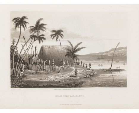
![South Seas.- [Wilson (William)] A Missionary Voyage to the Southern Pacific Ocean...in the Ship Duff, commanded by Captain Ja](https://cdn.globalauctionplatform.com/3bbf975b-3c75-4453-96c4-abe400e2508e/bbed2566-6b32-4767-9da5-abe400eecbb7/468x382.jpg)
Lot 24
South Seas.- [Wilson (William)] A Missionary Voyage to the Southern Pacific Ocean...in the Ship Duff, commanded by Captain James Wilson, first edition, 7 engraved maps, 5 folding, and 6 plates, all with delicate hand-colouring, maps in outline, list of subscribers at end, maps and plates foxed and a little offset, some with tears repaired, with long contemporary manuscript inscription from Robert Cowie of Highbury place near London to Rev. Thomas Allen of Pittsfield, Mass. on front free endpaper, and further inscription to Rev. Wm. Allen from his brother inscribed at head of title, contemporary mottled calf, gilt, rubbed, rebacked, [Ferguson 301; Hill 1894; Sabin, 49480], by S.Gosnell, for T. Chapman, 1799 § Keate (George) An Account of the Pelew Islands...composed from the Journals and Communications of Captain Henry Wilson... , first edition, stipple-engraved portrait frontispiece, folding engraved map, 15 engraved plates (some stipple-engraved) including folding panorama, all with delicate hand-colouring, tissue guards, errata leaf at end defective but no loss to text, some foxing to plates, occasional offsetting to text, typed notes on the voyage loosely inserted, modern half calf, old roan label preserved on spine, [Hill 907], 1788, 4to (2)⁂ The first is an account of the first missionary voyage to the South Pacific, including Tahiti, Tonga, Fiji and the Marquesas. The maps made an important contribution to Pacific cartography and the plates include a view of Rio de Janeiro. One of two issues published in the same year, this one on larger paper.The second item describes the tale of a voyage in the Pacific a few years earlier: "In 1783 the Antelope, commanded by Captain Henry Wilson, was wrecked on a reef near one of the Palau (Pelew) Islands, a previously unexplored group. The entire crew managed to get safely ashore, where they were well treated by the natives and eventually managed to build a small vessel from the wreck, in which they reached Macao. They took Prince Lee Boo, one of King Abba Thulle's sons, with them to England, where he made a very good impression. Unhappily, in spite of all precautions, he soon died of smallpox." Hill.
Lot 26
Voyages.- Arago (Jacques Etienne Victor) Narrative of a Voyage Round the World, in the Uranie and Physicienne Corvettes, commanded by Captain Freycinet, during the years 1817, 1818, 1819, and 1820, 2 parts in 1, first edition in English, half-title, folding lithographed map (trimmed with slight loss at right-hand edge), 25 fine lithographed plates after Arago, 2 folding at foot with short tears to edges, plates foxed and offset, title browned, light water-staining towards end affecting 2 plates, contemporary half calf, rubbed, rebacked, corners repaired, [Ferguson 885; Hill 298; Sabin 1865], 4to, 1823.⁂ France's first post-Napoleonic circumnavigation, by the official artist on the expedition, with more realistic plates than anything previously published and including descriptions of Hawaii, the Pacific Islands, Australia & New Zealand, South America and the Falkland Islands.
Lot 3
Atlases.- Bell & Co. (Allan, publishers) A New General Atlas of the World; comprising all the Improvements, Railroads, &c. recently introduced into...Europe, and the United States of America, with engraved title for Ackermann's 'New General Atlas' dated 1838 bound at beginning, 40 hand-coloured double-page engraved maps mounted on stubs, a few with marginal foxing, with additional hand-coloured double-page map of Buckinghamshire after the Reform Bill published by Duncan bound in at end (foxed and soiled, some tears and repairs), modern half calf, original printed label mounted on upper cover (rubbed), spine gilt, folio, London, Allan Bell & Co., Edinburgh and New York, 1837.

Lot 31
Voyages.- California.- Shelvocke (Capt.George) A Voyage round the World by the Way of the Great South Sea, first edition, folding engraved twin-hemisphere map, engraved title-vignette, 4 engraved plates, 2 folding, light staining to fore-edge at beginning, ink markings to margins, a few stains, slight worming to lower outer corner of a few leaves, bookplate of Booth Grey, contemporary panelled calf, rubbed, rebacked preserving old spine, new label, corners repaired, new endpapers, [Cowan pp.581-2; Hill 1557; Sabin 80158], 8vo, for J. Senex, 1726.⁂ Scarce account of Shelvocke's privateering adventures through the Pacific and with what Cowan calls "the fullest account of California, the natives and their features, of any of the old voyagers." The map depicts California as an island and two of the plates show natives of California; there are also early references to Californian gold and Peruvian guano. It has been suggested that Shevlocke's account of the passage around Cape Horn, where a sailor killed an albatross, inspired Coleridge's Rime of the Ancient Mariner.
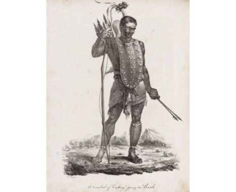
![Voyages.- [?Clerke Charles)] A Journal of a Voyage round the World, in His Majesty's Ship the Dolphin, commanded by the Honou](https://cdn.globalauctionplatform.com/3bbf975b-3c75-4453-96c4-abe400e2508e/755fd108-dfbf-4038-a922-abe400eedd42/468x382.jpg)
Lot 32
Voyages.- [?Clerke Charles)] A Journal of a Voyage round the World, in His Majesty's Ship the Dolphin, commanded by the Honourable Commander Byron ... in which is contained ... a Minute and Exact Description of the Streights of Magellan, and of the Gigantic People called Patagonians. Together with an Accurate Account of the Seven Islands lately discovered in the South Seas. By a Midshipman on Board the said Ship, folding engraved world map, engraved frontispiece of figures walking underwater with gourds over their heads to enable breathing, without the 14-leaf insert of additional material on the Patagonians, browned, worming to outer margin just touching text on a few leaves, contemporary sheep, rubbed, 8vo, for M. Cooper, 1767.⁂ Rare; ESTC lists only 3 UK copies (BL, Cambridge and Oxford) plus 2 others in America and Australia. This copy has "They have no fixed habitations, but certain moveable cottages" as final line on p.26, different to both the Brooke-Hitching copies sold at auction in 2014.

Lot 37
Voyages.- Cook (Capt. James).- Parkinson (Sydney) A Journal of a Voyage to the South Seas, in his Majesty's Ship the Endeavour, second edition, engraved portrait frontispiece by Newton (reinforced at fore-edge), 2 maps, one double-page, and 26 plates, with errata leaf but without rare 4pp. "Gomeldon" supplement, some foxing and soiling (foxing particularly to T gathering), some plates offset, tear to inner margin of title repaired, hole to c3 affecting a couple of letters, light water-staining to lower outer corner of a few leaves, modern half calf, [Hill 1309; Mitchell Library Cook 714; Sabin 58788], 4to, Charles Dilly...& James Phillips, 1784.⁂ Greatly-expanded account of Cook's first voyage first published in 1773, with an extensive Appendix including accounts of Cook's second and third voyages and a double-page world hemisphere map. Parkinson was employed by Sir Joseph Banks as draughtsman on the expedition but died on the homeward voyage.
Lot 4
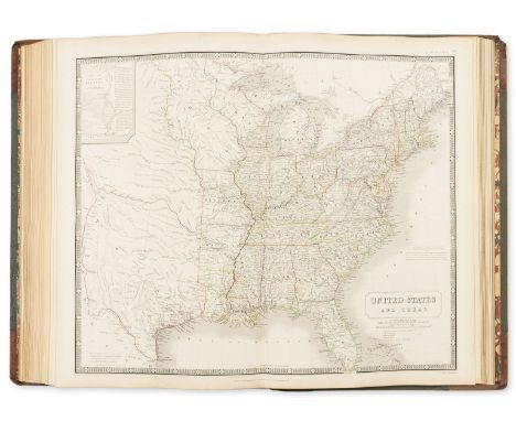
Atlases.- Black's General Atlas, 61 engraved maps on 55 sheets (numbered 1-60), by Sidney Hall, Hughes & others, most hand-coloured in outline, some double-page, very occasional light foxing or offsetting, tissue guards, with folding lithographed map of Illinois, Missouri & Texas Railway and another of Burlington, Cedar Rapids & Minnesota Railway loosely inserted, contemporary half diced russia, gilt, g.e., a little rubbed and faded, folio (440 x 320mm.), Edinburgh, Adam and Charles Black, 1844.

Lot 41
Voyages.- Robinson Crusoe.- Rogers (Woodes) A Cruising Voyage Round the World: First to the South-Seas, thence to the East-Indies, and homewards by the Cape of Good Hope ..., first edition, 5 folding engraved maps including Herman Moll's map of the world (a little soiled and stained, trimmed close and lacking lower right folding portion, reinforced at lower edge), other maps with a few tears to folds, old ink inscription "Jams. Jackson his Booke" below 'Memorandum' at end of preliminaries, text browned, modern half calf, [Hill 1479; Sabin 72753], 8vo, for A. Bell and B. Lintot, 1712.⁂ Famous account of privateering in the South Seas. Rogers set out from Bristol with William Dampier as his pilot and travelled along the coasts of Chile and Peru seeking out Spanish prizes. He landed on the Juan Fernandez islands in order to shelter from a storm, and there rescued the marooned Alexander Selkirk, the inspiration for Defoe's Robinson Crusoe.

Lot 43
Britain.- Cary (John) Cary's New and Correct English Atlas, being a New Set of County Maps, first edition, engraved title, dedication and 47 maps with partial hand-colouring, tissue guards, list of subscribers, modern calf ruled in blind, John Cary, 1787; Cary's New Map of England and Wales with Part of Scotland, second edition of 1824 version, engraved title, hand-coloured general map and 79 sheets (numbered 1-81), mostly engraved maps hand-coloured in outline but including dedication, key & scale as part of sheets, no sheets numbered 62 or 80 as issued (presumably unnumbered title and general map), 101pp. "List of Places" at end, contemporary sheep with wallet flap, rubbed, rebacked, red morocco label, flap worn and repaired, G. & J.Cary, 1828, both good clean copies, 4to (2)
Lot 45
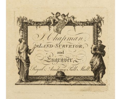
Essex.- Chapman (John) and Peter André. A Map of the County of Essex from an Actual Survey, engraved throughout, 26 double-page engraved sheets mounted on stubs, including pictorial title, list of subscribers and key map, all with full contemporary hand-colouring, some light browning and offsetting, occasional spotting, key map with crease to centre fold, with John Chapman's engraved decorative trade label to front pastedown, also bookplate of William Charles de Meuron, Earl Fitzwilliam, contemporary half calf, rubbed, rebacked, spine with grey morocco label and ruled in gilt, [Rodger 120], folio (550 x 380mm.), John Chapman, 1777.⁂ This fine large-scale map shows the county in close detail, including the names of all country houses and cottages, as well as the owner's name in many cases. There are also small inset plans of Colchester and Harwich Harbour, while the title depicts a fulling mill with two workers washing and beating cloth in the river.William Charles de Meuron Wentworth-Fizwilliam, 7th Earl Fitzwilliam (1872-1943), politician and army officer, one of the richest men in England once he had inherited the earldom on the death of his grandfather. He was born in a remote part of Canada, where his parents were reputedly travelling for his father's health, which later caused controversy over his inheritance to the title. It was suggested that he was a changeling, a baby brought into the family in an attempt to rid it of epilepsy and to claim the title for that side of the family
Lot 46
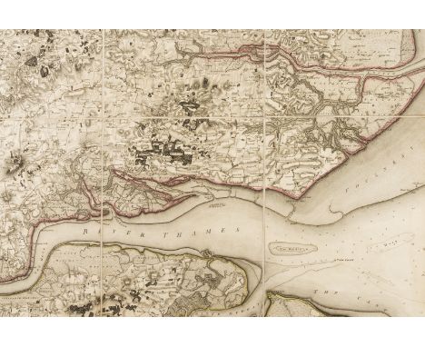
Essex.- Mudge (Lt. Col. William) Part the First of the General Survey of England and Wales, containing the whole of Essex, folding engraved map hand-coloured in outline, 1225 x 1830mm, dissected and mounted on linen, some very light offsetting, loose in contemporary russia slip-case with pull-off top, gilt arms to upper cover, rubbed, rather worn at edges, 4to, [1805].⁂ The second Ordnance Survey map to be published, following that of Kent in 1801.The illustration shows only a portion of the map.

Lot 47
Ireland.- Taylor (George) and Andrew Skinner. Taylor and Skinners's Maps of the Roads of Ireland, Surveyed 1777, first edition, large folding engraved map of Ireland, engraved vignette title, dedication/page of explanation and 288 road maps on 144 leaves (printed on both sides), 16pp. letterpress list of subscribers at end, folding map with tear to inner edge causing slight loss to border (laid down on linen), title browned, modern half calf, spine gilt with shamrocks and burgundy morocco label, tall 8vo, London, G. Nicol, and Dublin, W. Wilson, 1778.

Lot 48
Scotland.- Taylor (George) and Andrew Skinner. Taylor & Skinner's Survey and Maps of the Roads of North Britain, or Scotland, folding engraved pictorial title with dedication to the Duke of Argyll and his coat-of-arms, 61 folding engraved road maps on 31 sheets and folding general map, printed on both sides, folding letterpress leaf of index at end (browned and frayed at edge affecting border, reinforced), all mounted on stubs, first map torn and repaired, several maps soiled and worn at fold with occasional loss (repaired), engraved bookplate of Earl Cowper, contemporary half calf, rubbed, rebacked with gilt spine, 4to, for the Authors, 1776.
Lot 5
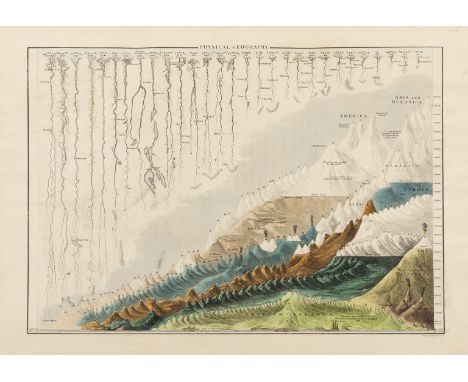
Atlases.- Johnston (Alexander Keith) The National Atlas of Historical, Commercial, and Political Geography, engraved title, 46 double-page engraved maps hand-coloured in outline, mounted on stubs, occasional light spotting or marginal soiling, contemporary half calf, g.e., rubbed, folio (545 x360mm.), Edinburgh & London, 1849.⁂ Includes five maps of Australasia with one separate and detailed map of Van Diemen's Land. One of the American maps shows Texas as an independent country.
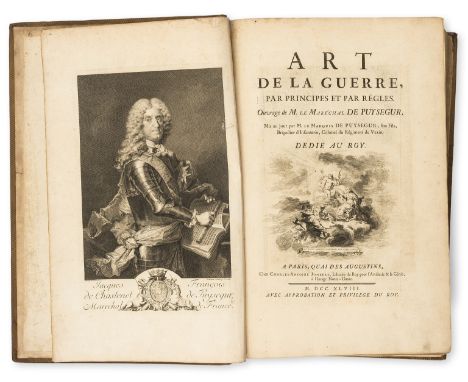
Lot 52
Military.- Puysegur (Jacques François Chastenet de) Art de la Guerre, par Principes et par Règles, 2 parts in 1, engraved portrait by Daulle after Tourniere, title-vignette and head- & tail-pieces by Cochin, part I with 32 engraved plates, mostly battle-plans, one folding, the rest double-page, part II with engraved decorative title and 13 maps & plans on 9 sheets, 2 double-page, the rest folding including large map of Paris, mounted on stubs, title a little soiled, some light offsetting to plates but text clean, Lord Amherst's copy with his ink signature to front pastedown, with Act of Parliament relating to Amherst loosely inserted, modern calf ruled and stamped in blind, spine ruled in gilt with red morocco label, very lightly mottled by damp, [Cohen-de Ricci 830], folio, Paris, Charles-Antoine, 1748.⁂ Field Marshal Jeffery Amherst, 1st Baron Amherst, KB (1717-97), army officer and Commander-in-Chief of the Forces during the American Revolutionary War. The loosely-inserted Act is "for settling and securing a certain Annuity on William Lord Amherst, and the Representatives of the late Jeffery Lord Amherst, in Consideration of the eminent Services performed by him during his Command in America, 12th August 1803."

Lot 57
Asia.- Blaeu (Willem Jansz.) Asia Noviter Delineata, map of Asia with carte-a-figures border, and decorated with animals, sea monsters and sailing ships, vignettes along the top include views and plans of the cities of Candy, Calecut, Goa, Damascus, Jerusalem, Hormuz, Banten, Aden and Macao, engraving with some early hand-colouring (green pigment showing through to verso), the figures heightened with bodycolour and gum arabic, on laid paper with large indistinct circular watermark, platemark 412 x 555 mm (16 1/2 x 21 3/4 in), French text verso, full margins with gilt edges, two printers' creases in the upper left quadrant, another small printers' crease in the lower centre to right of fold, otherwise a bright and clean impression with only minor surface dirt, unframed, [Amsterdam, circa 1643].

Lot 58
Asia.- East Indies.- Speed (John) A New Map of East India, map of south east Asia showing from India, Ceylon, Indonesia, Malay Peninsula, and the Philippines, engraving with hand-colouring, platemark 385 x 505 mm. (15 1/4 x 19 3/4 in), sheet 392 x 510 mm. (16 1/4 x 21 1/4 in), central vertical fold with some repairs to splitting to head and foot of fold, residual tape stain visible recto, a few careful repairs to worm holes, otherwise light handling creases, minor browning and surface dirt, unframed, Bassett & Chiswell, [1676].
Lot 6
Atlases.- Kiepert (Dr. H.), C.Graf, A.Graf & Dr. C.Bruhns .Hand-Atlas der Erde und des Himmels, 42nd edition, 70 double-page maps mounted on stubs, most engraved, some lithographed, all but a few with partial hand-colouring, some with splits to central fold reinforced, occasional light foxing or offsetting, flyer for 'Sonntags-Zeitung fur Deutschlands Frauen' printed on orange paper loosely inserted, modern half calf, spine gilt preserving old roan label, a little rubbed, part of old spine loosely inserted, (585 x 365mm.), Weimar, [1856-62] § Johnston (Alexander Keith) The Royal Atlas of Modern Geography, first edition, 48 double-page maps hand-coloured in outline, with watercourses printed in blue and some inset city plans, mounted on stubs, interleaved with indices for each map, advertisements tipped in at rear, very occasional foxing (mostly at beginning and end) but generally very clean, bookplate of William Phelps, damp-staining to endpapers, contemporary half russia, gilt, g.e., rubbed, upper cover a little spotted and faded, corners worn, rebacked in calf with gilt compartments and green roan label, (495 x 330mm.), Edinburgh and London, 1861, folio (2)
-
109182 item(s)/page