We found 109198 price guide item(s) matching your search
There are 109198 lots that match your search criteria. Subscribe now to get instant access to the full price guide service.
Click here to subscribe- List
- Grid
-
109198 item(s)/page


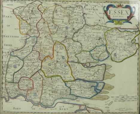
Lot 564
After Robert Morden (British,1650-1703): a late 17th century 1st edition map of Essex, copper plate, later hand-coloured, engraved by Sutton Nicholls, for Camden's Britannia (Swale and Churchill, London), circa 1695, with label verso for Frost and Reed Framers, dated 1946, 35 by 43cm, framed 38 by 45cm.Identified as first edition as Inworth, has been mis-spelt Inford.
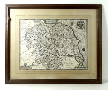
Lot 565
A Robert 'Mouseman' Thompson of Kilburn oak picture frame, carved with a mouse to top left side, 62 by 73cm, framing a map of Yorkshire after John Speed (British,1542-1629), with coat of arms cartouche, later hand-coloured, published by John Sudbury and George Humble, dated in the plate 1610, 39 by 52cm.

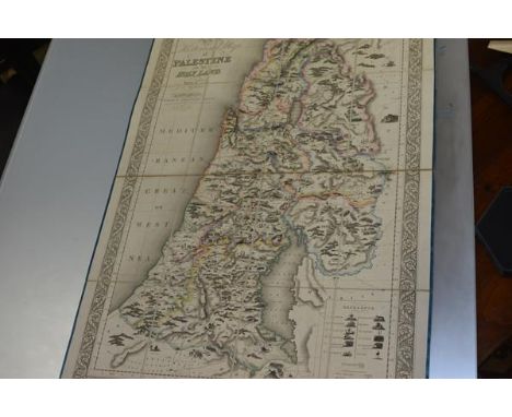
Lot 238
PALESTINE - ASSHETON, J.T., An Historical Map of Palestine or the Holy Land, Drawn by J.T. Assheton, London, Published by Samuel Leigh. Strand. Engraved by Sidney Hall, Bury Street, Bloomsbury, 1820, outline colouring, dissected and laid on linen, as issued, illustrated with vignettes of biblical events including battle scenes, the regions of the Twelve Tribes are delineated with colour, some soiling and light uniform browning, edged in silk ribbon (frayed), folding to original blue boards, total 110cm x 75.5cm, in original slip-case, extremities rubbed, corners bumped


Lot 273
Set of early 20th century travelling beam scales, chemist bottles, books incl. Sea Charts of the British Isles & Charts of War, by John Blake, other map related books, 19th century Bay of Honduras 1871 map, Joseph Rodgers & Sons cut throat razor in case, Timpo, Britains and other plastic soldiers etc in two boxes Condition Report Click here for further images, condition, auction times & delivery costs


Lot 838
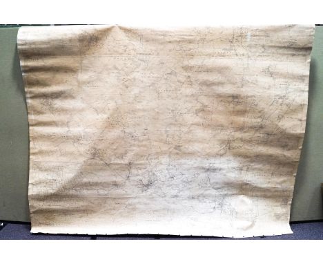
BRITISH WAR OFFICE MAP OF CHERBOURG & CAEN - topographical & road map, sheet 3a & 8 of the 40 sheet series, 90.5cm. x 78.5cm, showing coloured grid data within 'Lambert zone (red), 'Nord de Guerre' zone (blue) & 'English' (purple), 4th edition, published by the War Office London, 1943, with over 350 military personnel signatures in blue & black ink within the sea areas, including the 59th Newfoundland Regiment of Heavy Artillery. * the 59th fought alongside the Canadians in Normandy & throughout the campaign to liberate France during WW2.

Lot 861
HAGSTROM'S MAP OF HIGH SPOTS IN NEW YORK - colour sheet, map area 67cm. x 28cm., surrounding the map on 3 sides information of 'high spots' including theatres & motion picture houses, skyscrapers, department stores, museums, nightclubs & supperclubs etc., key to numbered spots & small birds eye view of the city in lower border, 'Drawn from Photo. Base, copyright by Fairchild Aerial Surveys, ca. 1940.


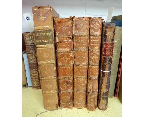
Lot 882
Britton (John) & Brayley (Edward) A Topographical and Historical Survey of the County of Southampton, 2 vol., extra illustrated with a total of 2 maps and 158 plates of which 2 arer hand coloured and 6 are folding, plus a 16pp manuscript index, foxed, contemporary half calf, spines and corners rubbed, Sheerwood, Neely & Jones, 1805, with Prosser (G.F.) Select Illustrations of Hampshire, extra illustrated with a total of 78 plates, foxed and toned, gutta percha binding perished, pages loose within contemporary half calf boards, spine splitting, J. & A. Arch, 1833 with Warner (Richard) Collections for the History of Hampshire and the Bishopric of Winchester, 6 vol. in 3, folding map and 60 of 63 engraved plates, foxed, contemporary calf, worn, 2 boards detached, For the Author,1795 with Hampshire, Extracted from Domes-Day Book, foxed, worn contemporary calf, boards detached, Faulder, 1789, 4to. (7)

Lot 885
Duthy (John) Sketches of Hampshire; Embracing the Architectural Antiquities, Topograhy, etc......, map and 7 plates, 1 colour folding, original blind stamped cloth, spine dulled, Winchester, Jacob & Johnson, 1839 with Hollingsworth (pub.) The Portsmouth Guide, engraved frontis.,contempoprary cloth with paper spine label, worn and faded, Southsea, 1828 with Valentine & Sons Ltd (pub.) Photographic View Album of Portsmouth and Southsea, Dundee, late 19thC. plus 20 related vol., v.s. (23)

Lot 887
Englefield (Henry C.) A Walk through Southampton, second edition, aquatint title plus 11 plates, contemporary calf, spine laid down, Southampton, Baker and Fletcher, 1805 with Bullar (John) A Companion in a Tour Round Southampton, third edition, folding map, hand coloured, slight tearing at folds, contemporary morocco, spine faded, Southampton, Baker and Fletcher, 1809 with Hampshire Independent (pub.) Copy of the Register of Persons Entitled to Vote in the Election of Members of Parliament for the Town and County of the Town of Southampton, contemporary half morocco, rubbed, Southampton, 1868, plus 17 related vol., v.s. (20)
Lot 889
Hankinson (T.J) Hankinson's New Descriptive Guide to Bournemouth, Christchurch, Wimborne, etc., folding map, illustrations and adverts., contemporary gilt decorated green cloth, Bournemouth, c.1892, with Brannon (Philip) The Illustrated Historical and Descripive Guide to Bournemouth...., folding plan, engraved frontis, contemporary cloth backed picture boards, Bournemouth, E.M. & A. Sydenham, 1875, plus a quantity of other Bournemouth Guides, including Ward Lock, v.s. (Box)
Lot 893
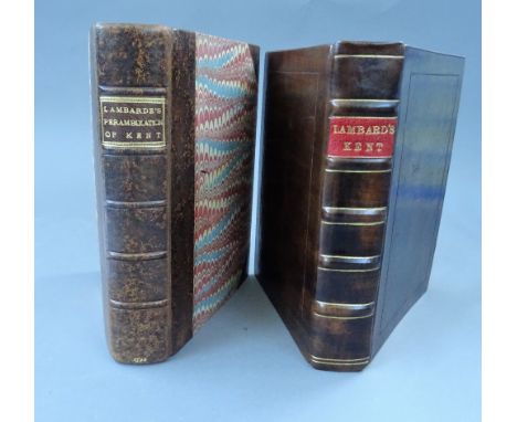
Lambarde (Wm.) A Perambulation of Kent: conteining the Description, Hystorie, and Customes of that Shyre . . . first published in the yeere 1576, and now increased and altered after the Authors owne last Copie (i.e. 2nd edition). title within wood-engraved decorated border, Heptarchy map (but not the 'Carde of Beacons'),black letter; newly rebound half calf & marbled boards, panelled spine with gilt label. Edmund Bollifant, 1596; together with (the Same) this copy also contains the folded 'A Carde, of the Beacons, in Kent' (but lacks title & defective at end); rebound gilt-ruled calf, panelled spine with red label. * the first of the English county histories; The 'Carde' (being post Armada) was not issued with the 1576 edition. Illustrated
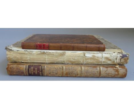
Lot 894
Lewis (Percival) Historical Inquiries Concerning Forests and Forest Laws, with Topographical Remarks, upon the Ancient and Modern State of the New Forest in the County of Southampton, folding hand coloured map, frontis., foxed, contemporary half calf, rubbed and faded, T. Payne, 1811; a second copy, incomplete, but with the author's manuscript annotations, with [Colines (Simon De)] An Abstract of all the Claims on the New Forest, in the County of Southampton, Entered at the Lord Chief Justice in Eyre's Court......., bookplate of Percival Lewis, re-backed contemporary calf, Salisbury, for the author, 1776, 4to and 8vo (3)
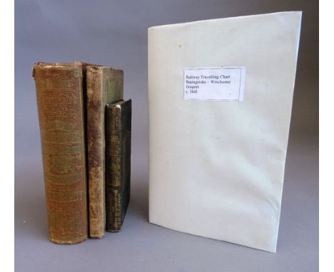
Lot 896
Measom, (George) The Official Illustrated Guide to the London and South - Western, North and South Devon, Cornwall, and West Cornwall Railways, and the Isle of Wight, portrait frontis., 2 folding maps, 1 creased with tape repair, text illus., contemporary cloth gilt, faded, 1864: The Official Illustrated Guide to the Brighton and South Coast Railways and their Branches, Including a Descriptive Guide to the Crystal Palace at Sydenham, illus., original cloth gilt, stained, n/d with Freeling (Arthur) The London and Southampton Railway Companion, folding map, torn with loss, folding chart and folding table, illus., foxed, original cloth gilt, rubbed and stained, J. T. Norris 1839 with Railway Chronicle (pub.) Travelling Charts. Basingstoke, Winchester, Gosport, concertina strip map with illustrated text describing the journey between Nine Elms and Gosport, 2870mm extended, folding into original printed wrappers, chipped c.1846. (4)


Lot 915
WISE (J.R.) The New Forest: its history and its scenery. Limited Edition. title vignette, engraved frontis., 12 etched plates (by Heywood Sumner), folded map & num. text illus.; morocco-backed pictorial 'wooden' boards, gilt top with other edges uncut, 4to. 1883. * contemp. armorial bookplate of John Dennistoun; the favoured 'Artist's Edition' of this well-known southern book; with a limitation of 350 numbered copied.
Lot 940
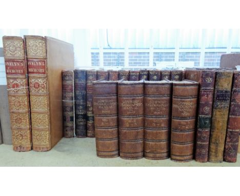
Evelyn (John) Memoirs Illustrative of the Life and Writings of John Evelyn.... 2 vol., portrait frontis to each vol. plus 9 plates, 2 folding, family pedigree, contemporary calf, upper board vol. 1 detached, Henry Colburn, 1819, with Gibbon (Edward) The History of the Decline and Fall of the Roman Empire, 12 vol., contemporary speckled calf, upper board vol. 1 detached, wear and missing letter pieces, T. Cadell Jun. & W. Davies, 1802, with Young (Arthur) A Six Months Tour Through the North of England, 4 vol., map and engraved plates, W. Strahan, 1771, plus other leather bound vol., vs (29)
Lot 537
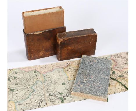
Greenwood's Large scale map of Suffolk, 1825, Map of the County of Suffolk from an Actual Survey made in the years 1823 &1824 by C. & J. Greenwood most respectfully dedicated to the Nobility, Clergy & Gentry of the County by the proprietors Greenwood, Pringle & Co, Regent Street Pall Mall London, published September 26th 1825, housed within the original leather clad book effect slip case, 168cm x 69cm


Lot 370
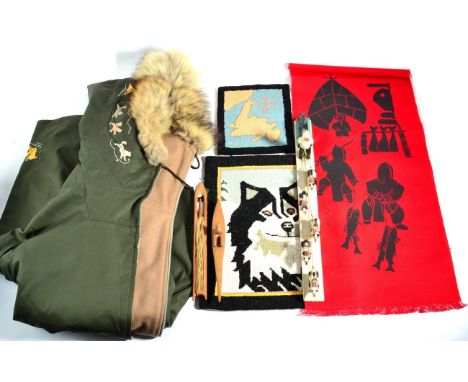
A Collection of Newfoundland and Labrador Artefacts, circa 1967-70, comprising a lady's green cotton Grenfell Parka, with front zip fastening, the cuffs and patch pockets hand embroidered with sledging scenes, the wolf fur trimmed hood hand embroidered with two dog sled teams (this is the logo for the Grenfell Mission) with wool lining; a carved and painted wood dog sled figure group; two Grenfell hooked silk small mats, one worked with a map of Newfoundland and Labrador, the other with the head of a wolf; a Holman small silk screen panel of Eskimo woman drying fish; a small carved wood canoe and a fishing net needle (7) **The origin of Grenfell Handicrafts dates back to the early 1900's when Sir Wilfred Grenfell began a cottage industry in northern Newfoundland to provide jobs for the area


-
109198 item(s)/page