
Paterson (Captain Daniel). Paterson's British Itinerary, Being a New and Accurate Delineation and Description of the Direct and Principal Cross Roads of Great Britain, 2 volumes, 1st edition, published Carington Bowles, 1785, double page engraved map of England & Wales with contemporary hand colouring, engraved calligraphic title to each volume, engraved dedication to volume one, 358 uncoloured engraved strip road maps (complete) on 179 pages, ink signatures to titles (one ink erased to volume 2), lacking half-titles, occasional spotting, marks and soiling, contemporary marbled calf gilt, with contrasting labels to spines, 8vo, contained together in slipcase, together with Luckombe (Philip), England's Gazetteer; or, an Accurate Description of all the Cities, Towns, and Villages, in the Kingdom, 3 volumes, 1790, folding engraved map frontispiece to volume one, contemporary sheep, red morocco title labels, joints cracked and slight wear at head & foot, 12mo (5)
We found 109182 price guide item(s) matching your search
There are 109182 lots that match your search criteria. Subscribe now to get instant access to the full price guide service.
Click here to subscribe- List
- Grid
-
109182 item(s)/page
Bird (Isabella L.). Unbeaten Tracks in Japan..., volumes 1 & 2, 3rd edition, 1880, black and white illustrations including folding map to rear of volume 1, bookplates to front pastedowns, original gilt-decorated green cloth, boards and spines slightly rubbed, 8vo, together with Buchan (John), The African Colony, Studies in the reconstruction, 1st edition, 1903, 2 colour folding maps, some minor toning, original blue cloth, spine slightly rubbed to head and foot, 8vo, plus Burton (Robert), The Anatomy of Melancholy, volumes 1-3, 1893, black and white portrait frontispiece with tissue-guard to volume 1, some minor toning, original uniform gilt-decorated green cloth, boards slightly marked, spines faded, 8vo, plus other late 19th-century and modern miscellaneous reference, all original cloth, many in dust jackets, G/VG, 8vo/4to (6 shelves)
Rudder (Samuel). A New History of Gloucestershire. Comprising the Topography, Antiquities, Curiosities, Produce, Trade and Manufactures of that County..., also the Ecclesiastical, Civil and Military History of the City of Gloucester from its first foundation to the present time..., published Cirencester 1779, title page creased, folding engraved map of Gloucestershire by J.Bayly, two further single page maps of the Home Park estate near Cirencester and Oakley Great Park, thirteen uncoloured engraved folding plates of stately homes and a single page engraving of a cross section of Pen-Park hole, ownership signature of Thomas S. Bazley (1797 - 1885) to front endpaper, decorative etched bookplate of Gardner S. Bazely, the bookplate is a play on his name as it depicts a gardener standing under an arbour, with a later Hatherop Castle library stamp, modern half calf with contrasting morocco label to spine, but retaining contemporary marbled boards, folio Thomas Bazley was a cotton merchant and MP who aquired estates in Hertfordshire and Gloucestershire eventually settling at Eyford Park near Lower Slaughter in Gloucestershire. His widow the Dowager Lady Bazley died at the Vicarage in Bibury aged 93 in 1897. (1)
Norman (Dorothy). Nehru, The First Sixty Years, volumes 1 & 2, 1st edition, 1965, black and white frontispiece and map, later inscription to front endpapers, original plum cloth in dust jackets, covers slightly rubbed with minor loss to head and foot, 8vo, together with Souza (George Bryan & Turley, Jeffery S.), The Boxer Codex, Transcription and Translation of an Illustrated Late Sixteenth-Century Spanish Manuscript, 1st edition, 2016, original illustrated boards, 8vo, and Rungta (Radhe Shyam), The Rise of Business Corporations in India 1851-1900, 1st edition, CUP, 1970, original blue cloth in dust jacket, plus other modern India reference and related, mostly original cloth, many in dust jackets, G/VG, 8vo (3 shelves)
Virtue (George, pub.). The Picturesque Beauties of Great Britain - Kent, 1828-[1830], engraved frontispiece of Canterbury Cathedral, engraved title (letterpress title not present), folding engraved map, 128 engraved plates on sixty-four leaves, light toning, occasional spotting and offsetting, all edges gilt, contemporary morocco, slightly rubbed to extremities, 4to, together with Cassell & Company (Publishers), Our Own Country, Descriptive, Historical, Pictorial, 6 volumes in three, circa 1870, engraved frontispieces, plates and illustrations, occasional scattered spotting, contemporary red half calf gilt, 4to (4)

*Darton (W. & T., publisher). Walker's Tour Through England and Wales, a New Pastime, Published for the Author, January 2nd, 1809, hand-coloured engraved map, with rules on either side, in eighteen sections mounted on linen, one or two minor marks, 53.5 x 65.5cm (21 x 25.75ins), housed in original marbled slipcase with engraved title label on front, a little dusty and rubbed Whitehouse, p.13. (1)

Wright (Thomas). The History of Ireland; from the earliest period of the Irish annals, to the present time, 3 volumes, John Tallis and Company, circa 1840s, numerous steel engraved plates, double-page map by J. Rapkin, hand-coloured in outline, marbled edges and endpapers, contemporary uniform dark blue half morocco, gilt-decorated spines, a little rubbed and some minor marks (generally in good condition), 4to, together with Woodward (B.B.), The History of Wales, from the earliest times, to its final incorporation with the Kingdom of England, Virtue & Co., circa 1850, numerous steel engraved views after Gastineau, contemporary dark blue half morocco gilt, a little rubbed, small thick 4to (4)

Anglesey & Caernarvonshire. Saxton (Christopher), Mone Insulae modo Anglesey et Caernarvans duorum borialis..., circa 1579, engraved map with contemporary hand colouring, strapwork cartouche and mileage scale with the coat of arms of Elizabeth I and Thomas Seckford, good margins, slight mount staining, a few stains to image, 360 x 490 mm The first printed map of Anglesey and Caernarvonshire. (1)


*Berkshire. Saxton (Christopher & Hole William), Comitatus Bercherie vulgo Barkshyre qui olim sedes Atrebatum, circa 1610, engraved map with contemporary hand colouring, strapwork cartouche and mileage scale, 235 x 325 mm, mounted, framed and glazed Uncommon with contemporary hand colouring. (1)
British county maps. Blaeu (Johannes), Comitatus Dorcestria sive Dorsettia vulgo Anglice Dorset Shire, circa 1650, uncoloured engraved map, 385 x 500 mm, no text on verso, together with, Speed (John), The Countie Westmorland and Kendale the chief Towne described with the Armes of such Nobles as have bene Earles of either of them, published George Humble, circa 1627, uncoloured engraved map, inset town plan of Kendal, large strapwork cartouche, compass rose and mileage scale, heavily wormed with two margins and central fold strengthened on verso, 385 x 510 mm, English text on verso, with, Morden (Robert), The County Palatine of Lancaster, The County Palatine of Chester, Westmorland, Cumberland, The Bishoprick of Durham [and] Northumberland, circa 1722, together six uncoloured engraved maps, 'Cumberland' with some spotting, old folds, each approximately 370 x 430 mm, plus, Saxton (Christopher & Hole William), Eboracensis comitatus pars Septentrionalis vulgo North Riding [and] Eboracensis comitatus..., pars Orientalis vulgo East Riding, circa 1610, two hand coloured engraved maps, 195 x 345 mm and 200 x 250 mm respectively (10)

British Isles. Munster (Sebastian), Das Ander Buch Beschreibung Engellandts und Schottlandts, circa 1598, uncoloured woodcut map, with title above map, map size 255 x 170 mm, German text on verso, together with a woodcut panorama of Edinburgh from the same source, 100 x 185 mm, German text below and on verso of print Shirley. Early Printed Maps of the British Isles, no 122. Published in the 'Cosmographia'. (2)
British Isles. Lotter (Tobias Conrad), La Grande Bretagne ou les Royaumes D'Angleterre et D'Ecosse comme aussi le Royaume D'Irlande divis‚e par provinces, published Augsburg, circa 1780, engraved map with contemporary hand colouring, large ornate black and white cartouche, slight dust soiling and staining, 495 x 585 mm, togther with, Chatelain (Henry Abraham), Nouvelle carte d'Anglettere d'Ecosse et d'Irlande avec des instructions..., circa 1720, uncoloured engraved map of the British Isles, two inset hemispheral maps including one with an insular California, columns of text, old folds, 480 x 625, with, Nouvelle Carte du Gouvernement civil d'Angleterre et de celuy de la ville de Londres, circa 1720, uncoloured engraved map, columns of text with an inset plan of London, 350 x 460 mm (3)


Tolkien (J.R.R.). The Fellowship of the Ring, 2nd impression, 1954; The Two Towers, 2nd impression, 1955; The Return of the King, 1st edition, 1955, folding map at end of each, original red cloth, some fading at foot of Fellowship and Return spines, dust jackets, spines toned with chips and losses (Fellowship spine vertically split), 8vo (3)

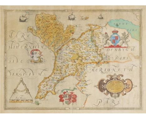
*Cheshire. Saxton (Christopher & Hole William), Cestriae comitatus Romanis legionibus et coloniss olim insignis vera et absoluta descriptio, circa 1610, engraved map with contemporary hand colouring, 'open book' cartouche, 265 x 305 mm, mounted, framed and glazed Uncommon with contemporary hand colouring. (1)

Tolkien (J.R.R.). The Return of the King, 1st edition, 1955, folding map at end, original red cloth (bump at head of spine), dust jacket, spine a little faded, one or two light stains, 8vo, together with The Fellowship of the Ring, 10th impression, 1961, The Two Towers, 7th impression, 1960 (in trimmed and repaired jacket), The Return of the King, 7th impression, 1961 and 16 cast metal figures of characters from the books including Gandalf, Saruman, Boromir, Legolas, some hobbits etc (5)

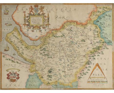
*Cheshire. Saxton (Christopher), Cestriae comitatus (Romanis legionibus et colon˜s olim insignis) vera et absoluta effigies, [circa 1579] engraved map with contemporary hand colouring and some later enhancement, engraved by Francis Scatter, ornate strapwork cartouche and mileage scale with the coat of arms of Thomas Seckford, 390 x 505 mm, mounted, framed and glazed The first printed map of Cheshire. (1)
![Cigarette cards. A set of twenty-five 'British County Maps & their Industries', pub. John Player & Sons, [1914], each card wi](https://cdn.globalauctionplatform.com/2f4aa010-bbf9-4378-adf4-a64000b7ea08/18698239-fa9d-4c9d-889d-563047eb1877/468x382.jpg)
Cigarette cards. A set of twenty-five 'British County Maps & their Industries', pub. John Player & Sons, [1914], each card with a colour lithographic map over a scene from an industry relevent to the county card, a few cards with slight staining and adhesion on verso, each approximately 70 x 35 mm, English text on verso, retaining original glassine wrapper, Counties are Lancashire, Lincolnshire, Munster, Kent, Perth, Northampton, Stafford, Bedford, North Wales, South Wales, Connaught,Cornwall, Edinburgh, Dumbarton, Yorkshire, Ulster, Nottingham, Norfolk, Cheshire, Devonshire, Roxburgh, Leicester, Hampshire, Monmouth & Northumberland. (25)

Copenhagen. Homann (Johann Baptist), Accurate Vorstellung der Beruhmten Meer-Enge Zwischen der Nord und Ost See der Sund Genant, mit der herumligenden Gegend von Seeland und Schonen nebst der Koniglich-Danischen Haupt und Residentz Stadt Copenhagen..., published Nuremberg, circa 1720, engraved map with contemporary hand colouring, of the Sund Sound between Copenhagen and Malmoe, panorama of Copenhagen below the map, inset city views of Helsingburg, Landscron, Malmoe and Cronenburg, short split at base of central fold, slight fraying to lower margin but with no loss, 495 x 590 mm (1)
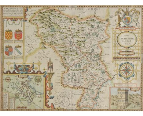
*Derbyshire. Speed (John), Anno Darbieshire described, published John Sudbury & George Humble, circa 1627, hand coloured engraved map, inset town plan of Derby and Buxton well, large strapwork cartouche and compass rose, central fold strengthened on verso, some creasing, 390 x 510 mm, mounted, framed and double glazed, English text on verso (1)

Druks (Michael). Druksland, 15 January 1974 11.30 A.M. Physical and Social, published The Netherlands, 1975, colour lithographic allegorical map based on a portrait of the artist, 440 x 340 mm, together with, New Internationalist Publications Ltd. publisher, Map of the World, Peters Projection. A Map which represents countries accurately according to their surface areas, circa 1980,colour printed map, old folds, 590 x 805 mm, with one other map similar (3)
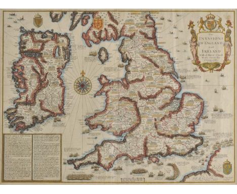
*England & Ireland. Speed (John), The Invasions of England and Ireland with al their civill wars since the conquest, published Thomas Bassett & Richard Chiswell, [1676], hand coloured engraved map, decorative cartouche, compass rose and numerous rhumb lines, 385 x 520 mm, mounted, framed and double glazed, English text on verso (1)
![*Flintshire. Speed (John), Flint-shire, published John Sudbury & George Humble, [1616], hand coloured engraved map, inset tow](https://cdn.globalauctionplatform.com/2f4aa010-bbf9-4378-adf4-a64000b7ea08/a14d9ad6-4e20-464d-fd53-58e2a46093e5/468x382.jpg)
Folding maps. Dower (John), Ireland shewing the Roads, Railways &c. Constructed since the Ordnance Survey of 1839, by Charles Saunderson, published London, Dublin & Edinburgh, circa 1860, engraved map with contemporary outline colouring, sectionalised and laid on linen, near contemporary ownership signatures on verso, 990 x 815 mm, contained in contemporary gilt cloth slipcase, a little stained and worn, together with, Collins (H.G., publisher), Collins' Railway Map of England & Wales and part of Scotland, shewing the Inland Navigation by means of Rivers and Canals together with the Rail and principal Turnpike Roads, from the most recent surveys, circa 1860, lithographic map with contemporary outline colouring, sectionalised and laid on linen, slight staining, 940 x 670 mm, contemporary cloth boards, faded and worn, with, Cary (John), A New Map of Shropshire, divided into Hundreds, exhibiting its Roads, Rivers, Parks &c., 1828, engraved map, sectionalised and laid on linen, bright contemporary outline colouring, oval cartouche, 555 x 490 mm, contained in a contemporary card slipcase with printed label to upper board, worn and rubbed, plus, Walker (J & C), Somersetshire [and] Northamptonshire, 1846 & 1836 respectively, two engraved maps sectionalised and laid on linen, contemporary outline colouring, some dust soiling to Northamptonshire, each approximately 335 x 395 mm, contemporary cloth boards with printed labels to upper boards (5)

Fruit box labels. A mixed collection of forty-six labels, all illustrated with a map, mid 20th century, photolithographic box labels for lemons, sweet potatoes and wine, showing maps of Louisiana, California, Florida and Panama, five different patterns with numerous duplicates, various sizes, mostly unused condition (46)

![*Lancashire. Saxton (Christopher), Lancastriae Comitatus palatin vera et absoluta descriptio [circa 1579], engraved map with](https://cdn.globalauctionplatform.com/2f4aa010-bbf9-4378-adf4-a64000b7ea08/f55ccdf7-ac6d-4f4a-e49e-325119e20443/468x382.jpg)
*Lancashire. Saxton (Christopher), Lancastriae Comitatus palatin vera et absoluta descriptio [circa 1579], engraved map with contemporary hand colouring, decorative cartouche, together with the coats of arms of Elizabeth I and Thomas Seckford, 395 x 480 mm, mounted, framed and glazed The first printed map of Lancashire. (1)
*Lodge (John). A New Map of Cheshire from the best Authorites, published J.Murray, A New Map of Sussex from the Latest Authorities, published R.Butters [and] A New Map of Hampshire from the Latest Authorities, published J.Murray, [1782 - 1790], three engraved maps with near contemporary outline colouring, some toning and slight creasing, each approximately 275 x 330 mm, mounted, framed and glazed, together with, Morden (Robert), Hertfordshire [1695 or later], hand coloured engraved map, 375 x 450 mm, framed and glazed The first three maps appeared in 'The Political Magazine' published between 1782 - 1790. (4)

London. Cary (John), Cary's New and Accurate Plan of London and Westminster, the Borough of Southwark and parts adjacent: viz. Kensington, Chelsea, Islington, Hackney, Walworth, Newington &c with an Alphabetical list of upwards of 500 of the most principal streets with references to their situation, 1792, engraved map, sectionalised and laid on linen, contemporary outline colouring, with a list of over 500 of the principal streets, contained in a contemporary marbled card slipcase with printed label to upper board, worn and rubbed at extremities, 815 x 1245 mm J.Howego. The Printed Maps of London, no.184, state 3. (1)


A collection of 19th century maps relating to Ireland and including four examples from Lewis's topographical dictionary by R Creighton and showing Cavan, Tipperary, Longford and Leiterim, approx. size 26 x 20 cm together with a map of Ireland by J Rapkin, 34 x 25 cm and a further map of County Wicklow framed together with a 19th century engraving of Bray Head, all framed

A late 17th century coloured map of Europe by Pierre Du Val engraved by Liebaux and dated 1684, 42 x 53 cm in oak frame with gilt slip together with a 19th century map of Nebraska, Dakota, Idaho and Montana published A J Johnson of New York and dated 1865 (text verso under frame), 39 x 59 cm in wide oak frame

A collection of 19th century maps including example showing Gloucestershire with vignettes of Gloucester Cathedral, New Spa Cheltenham and Tewkesbury Abbey, 26 x 20 cm in gilt frame, a mounted map of Gloucestershire from Lewis's topographical dictionary, Glastonbury, Honiton and Bridgnorth from the Ordnance Survey (one framed and two mounted), a framed engraved design for a circular skylight, and an early 19th century coloured engraving of a butterfly on a cucumber, both framed, also together with A Century of Punch, edited by R E Williams


Travel: Livingstone, David Missionary Travels and Researches in South Africa, with engraved illustrations, portrait and folding map, London: John Murray 1857 half-bound gilt calf, 8Vo, to/w Darwin, Charles, Journal of Researches....., London: T. Nelson & Sons 1890 quarter morocco and gilt, 8Vo & Caine, WS, MP, A Trip Around the World in 1887-8, London George Routledge and Sons 1888, dec. red cloth 8Vo (3)


-
109182 item(s)/page