We found 109198 price guide item(s) matching your search

Refine your search

Year

Filter by Price Range
  • List
  • Grid
  • 109198 item(s)
    /page

Lot 398

Gall & Inglis' Map of the World.

Lot 201

A quantity of local maps and ephemera including Burrow's guide Map of Taunton; Cheddar Cliffs and Caves views booklets and others

Lot 366

A 1794 copper Halfpenny Token the obverse with image of Neptune and trident, the reverse with Whaling scene "Whale Fishery Payable at I Fowler, London" ef; a Taunton Penny Token c.1800; a copper medallion "May Great Britain Ever Remain the Reverse" to one side and "A Map of France" etc dated 1794; some CWS bread tokens and others

Lot 28

A Victorian needlework map sampler, of the British Isles, by Ellen C. Farmer, 1874, 28 x 22in (71 x 56cm) and a floral needlework panel, 40.5 x 5in (103 x 13cm). (2)

Lot 102

A 1926/27 Harding's Guide Map to the District of Bridgwater, the folding map with calendar and advertisements

Lot 618

Box of mixed ephemera including Essex Railways Map, 1900 Epping Monthly Record, GVl commemorative service programme, 'Hastings and Eastbourne Illustrated, Illustrated London News 1919, other souvenir programmes including Royalty and Art Deco photograph of woman and ball (qty)

Lot 676

London Underground railway map 1937 No 1, also 1951 central area bus map, 1967 Green Line routes plus similar maps (8)

Lot 17

GWR paperwork miscellany comprising a beautiful, linen bound, fold-out 'Map Of The Great Western Railway And Its Connections dated 1909; GWR official Pamphlet/Booklet 'Somerset'; official Booklet 'Brunel & After' dated 1925; official Booklet 'Somerset Ways'.

Lot 103

Poster, LNWR D/R fully titled depicting a central map to the image with coloured Vingnettes around the outside. Has been mounted to hardboard then onto chipboard and is contained within a pine, unglazed frame. A rare poster that would benefit from being remounted.

Lot 127

Poster, British Railways D/R "Cheltenham Spa For The Cotswolds" (Illustrated Map) by Lee, printed by AAG Ltd. Small amount of loss at left hand corner and right hand edge.

Lot 167

G.W.R. Tin plate screen printed map of the system, in original Oak frame, in V.G. condition.

Lot 206

Poster, British Railways D/R 'The Bonnie, Bonnie Banks of Loch Lomond' by Nicholson. Depicts a relief map of the area from Ardlui in the north to Balloch Pier in the south. Published by British Railways Scottish Region and printed by McCorquodale, Glasgow. Rolled with minor creases and tears.

Lot 215

Poster, British Railways D/R "'Isle Of Wight" artwork by Baylis & Adam. Shows central map of the island with railways clearly annotated and several arty scenes around the periphery. Published by British Railways Southern Region and printed by Leonard Ripley & Co. Some minor tears and defects.

Lot 228

GWR Menu from the Torbay Express dated December 18th 1930. Typical, triple fold, six pages with the addition of the festive, holly border and having the 4/- Luncheon Menu on the cover. Also the list of hotels and the conductors name "F. Wray". Inside is the system Map with distances from Paddington to places of interest. Back covers advertise the Fishguard Bay Hotel with image and a page of special events for 'your Christmas Holiday' and also the Wine List. Some staining but a lovely item from 'Torquay Car (1)'

Lot 366

A Group Of 5 Prints: A Hunting Print, 1863, A 19th Century Germany Print, A Print Of A Chough, A Map Of Northants, A Chinese Embroidery And A Mirror With A Floral Painting

Lot 84A

A map of the South & West wilts Hunt. Framed.

Lot 124

'The East Riding of Yorkeshire' 17th century hand coloured map by Johannes Blau published 1645

Lot 2566

The Angler and the Trout by huish Edge. Fly Tying by Major Sir gerald Buttard B. T. Where to Fish,The field Guide Rivers and Lakes with Map. trout in Lakes and Reservoirs by ernest Philips. Modern Salmon Fishing by Antony Bridges. The Complete angler by Izaak Walton and Charles cotton. (6)

Lot 2587

The Salmon Rivers of england and Wales by Augustus grimble, containing eighty nine illustrations and a map. Second Edition, circa 1913.

Lot 2592

The Mad Hatters, by douglas Sutherland and Squire osbaldeston, his biography, edited, with commentary by E. D. Cuming, with sixteen illustrations in colour and seventy five in black and white and a map.

Lot 191

18TH CENTURY HAND COLOURED ENGRAVING, “The Road from Kings Lynn to Norwich ------ with Map of Norfolk Below”, 7” x 5”

Lot 527

An impressive carved wood wheel barometer, circa 1870 the case with hygrometer, large thermometer tube, the main silvered dial engraved to the centre with a map of the world within a zodiac chaper, the case carved with leaf and bud decoration, the shoulders with crouching infants, the plinth with a silvered plaque, signed Guanzirolli" co, 106 Hatton Garden, London 155cm high

Lot 401

Style of Andre Dunoyer de Segonzac 1884-1974- View of Notre Dame and the Seine; pen and black ink and watercolour over pencil, bears signature, 26.5x22.3cm: Pierre vander Aa 1659-1753- "Carte du Gouvernment de Languedoc", circa 1730; hand-coloured engraved map, 26.4x38.2cm: B Righetti, Italian School early-mid 20th century- Alpine landscape with cypress trees and a cottage; watercolour, signed, 41.5x27cm., (3)

Lot 506

Giovanni Antonio Magini 16/17th century- "Latium Seu Territorieum Romae",1597-98; engraved map, 18x14cm

Lot 523

Franz Hogenberg 16/17th century- "Canterbury", 1588-1624; hand-coloured engraved map, framed and glazed, 42x29cm

Lot 7

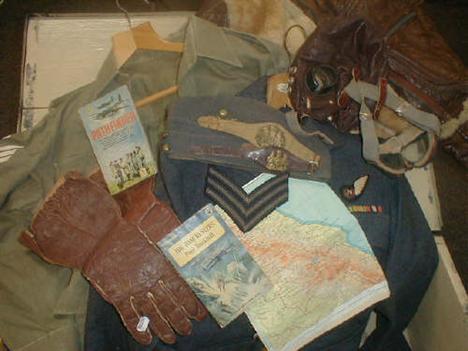
A painted pine travel trunk of Warrant Office 1802864 Langley, 77 Waterloe Road, Dunstable Beds, containing RAF jacket, casuals, flying jacket, leather gloves, silk glove inserts, flying helmet with goggles, uniform hat with badge, regiment wrist straps, fabric map of Sumatra/Java, braces, badges, paperback books etc.

Lot 374

The Holy Bible, containing the Olde Testament and The New, Robert Barker 1615, with undated genecelogies and double page map of Canaan, The Whole Book of Psalms, worn card covers and hand stitched reverse hide spine.

Lot 379

Thoroton (Robert). The Antiquities of Nottinghamshire, London, printed by Robert White, for Henry Mortlock, at Sign of the Phoenix in St. Paul's churchyard, and at the White Hart, in Westminster Hall, 1677, title page in red and black imprimatur, numerous engraved plates including folding county map and crests, a.e.g., modern gilt tooled red moroc, gilt lettering, raised spine bands by A. Price, Oxford.

Lot 385

Thoroton (Robert) - The Antiquities of Nottinghamshire, title printed in red and black, 1677, double sheet eng. map, 4 eng. plates of arms printed recto and verso, eng. plates, some folding, orig. calf, re-backed, later spine, bookplates of Guliemus Bree, Rector of Allesley and George Tollet Esq.

Lot 391

Throsby (John) pub - Thoroton's History of Nottinghamshire, 1797, 3 vols. portrait frontis, vols I & II, foldup map vol III, illus. throughout, orig calf re-backed, later spine.

Lot 425

The Farther Adventures of Robinson Crusoe; being the life and last part of his life and of the strange surprising accounts of his travels round three parts of the globe, written by himself. Printed for W. Taylor 1719. Ex libris W. Wilde, Blidworth. (No map).

Lot 567

A. Leonardo Bufalino. Subject: Map of ancient Rome, Medium: Hand tinted steel engraving, dated 1748, Size: 45 x 68 cm, m/g & f.

Lot 573

E Sharland West Door, Litchfield Church, etching Map of Aberdeenshire, map after Saxton of Lancashire, Lighthouse prints (6)

Lot 636

J C Barbie 'Carte De L'Afrique', coloured engraved map of Africa, 19th century, 30cm high x 22cm wide

Lot 28

STEVENSON, Robert Louis, 'Island Nights' Entertainment', Cassell & co. 1893. ill. Browne & Hatherell, Frontis, cold. map. Illus. a.c.f. hinges weak. glt. cl. worn. Tog.with other 1st edns. by same. 36

Lot 47

MILLER, William, 'The Balkans', Fisher Unwin, 1923, 3rd. edn. fldg. map. cl. bd. spine sunned. Tog.with SITWELL, Sacheverell, 'Romanian Journey', Batsford, 1938. cold. frontis. Tp. foxed, chipped d/w. Plus other topography, travel. 23

Lot 71

CHANDLER, Richard, 'Travels in Greece or An Account of a Tour made at The Expense of The Society of Dilettanti', Oxford, 1776. Fo. 7 plts. Folding map foxed & creased, with tear. Closed tear to plan of Port Piraeus. 1/2 bds. scuffed & worn. (loss to upr. corner bd.) Tog.with WHELER, George, 'A Journey into Greece by George Wheler Esq. in Company of D'Spon of Lyons', London, 1682. fo. Lacks maps & plates. Def. 2

Lot 96

STANLEY, Arthur Penrhyn, 'Lectures on The History of The Eastern Church', Murray, 1876, 5th edn. 4to. Full leather scuffed. Tog.with 'Sinai and Palestine', Murray, 1887. 4to. by same, frontis map & othr maps a.c.f. plus THOMAS, Edward, J. 'The Life of Buddha', Kegan Paul, 1927. Plus others. 33

Lot 171

FURBY,G. (pub). 'Picturesque Excursions from Bridlington - Quay being A Descriptive Guide to the most Interesting Scenery in that Neighbourhood', Bridlington, 1836, 2nd. edn. Frontis map. 5 plts. foxed. slim 8vo. cl. bds. worn & faded.

Lot 173

INGRAM, James, 'Memorials of Oxford', Parker, 1837, engs. John Le Keux. 8vo. 3 vols. glt. cl. loss to spine vol. 1. Tog.with 'A Pocket Companion to Oxford or, Guide Through the University', Oxford, 1768. frontis. map. 7 engrs. 6mo. 4

Lot 285

THOMAS KITCHIN - A new improved map of Oxfordshire, from the best surveys in intelligences divided into its hundreds, double page engraving, with hand coloured borders, 28 1/2" x 21".

Lot 298

AN 18TH CENTURY ENGRAVED MAP - 'Nouvelle Carte pour Servir a l'Histoire de l'Empire d'Occident depuis les premieres Empereurs ro, double page engraving, hand coloured, 20" x 24", together with a collection of a plastic wallet containing a collection of 18th century hand coloured road maps, 8" x 5 1/2"; further maps, mainly 19th century and miscellaneous prints and engravings.

Lot 331

An 18th Century Hand Tinted Derbyshire Map, framed. 10½ ins (27 cms) x 8¼ ins (21 cms).

Lot 540

Alex Hogg, Antique Hand Coloured Map "The World in 3 Sections", framed, 25cm x 42cm

Lot 927

A coloured map of Oxfordshire, a watercolour of a seated nude female, another of flowers, and a print

Lot 147

William Berry The History of the Island of Guernsey, published London 1815, complete with map and 29 engraved plates, 348pp.

Lot 149

Kelly's Directory of the Channel Islands published 1915, with single folding map and advertisements, bound in a red cover

Lot 285

A map of the Channel Islands and English Channel depicting Guernsey and Jersey with hand coloured vignettes of St Peter Port, Castle Cornet, Druid's Alter, Mont Orgueil Castle and the Jersey Coast, drawn and engraved by J.Rapkin 1851. 14 x 9.5in (36 x 24cm).

Lot 286

John Speede A map entitled The Invasions of England and Ireland with all their Civil Wars since the Conquest, sold by George Humble, first edition circa 1627, with coloured cartouche and compass rose. 16 x 21in (41 x 53.5cm).

Lot 1709A

Henricus Hondius (1587-1638), Duche de Bretaigne, engraving with hand colouring, unframed, 39cm x 50cm.; together with a map of Anjou, 1579. (2)

Lot 1713

J. Blaeu, Map of Hampshire, engraving with hand colouring, 47.5cm x 58cm.; together with a reproduction map of the world. (2).

Lot 1733

Emmanuel Bowen, Map of Kent, engraving with hand colouring, 55cm x 72cm.

Lot 1759

Henrici Hondi, Map of South East England, engraving with hand colouring, 36cm x 45cm.

Lot 1782

Christopher Saxton, Map of Gloucestershire, engraving with hand colouring, 29cm x 31cm.

Lot 44

After Robert Morden - 'Surrey' (Map of the County), engraving with coloured outline.

Lot 148

After T. Badeslade - 'A Map of Hampshire', mid-18th Century engraving with near period colour, together with a collection of decorative pictures.

Lot 517

A "Stolzenberg System" 9 section map cabinet with up and over compartments enclosing pullout slides, the base with 6 pullout scroll maps, length 49"

Lot 541

T JEFFERYS, "The World Agreeable to the Latest Discoveries", hand coloured twin hemisphere map with title cartouche, allegorical figures depicting the seasons, and a landscape with ruin, 8" x 15 1/4", framed

Lot 1319

An Ordnance survey map of the Aldershot Command, 1932, War Office map of North West Europe 1915 and Daily Express map of Europe WW11 (3)

Lot 1528

Christopher Saxton, William Kip, Northamtoniae, hand tinted map, second half 17th century, 37 x 29cm

Loading...Loading...
  • 109198 item(s)
    /page

Recently Viewed Lots