

Portraits des Généraux Français, faisant Suite aux Victoires et Conquêtes des Français, Paris, 1818, 2 vols., 8vo, 152 engraved portraits, contemporary calf. With 5 other miscellaneous early 19th-century books. (7)Portraits des Généraux Français, faisant Suite aux Victoires et Conquêtes des Français. Cette Collection sera Jointe a la Biographie Militaire Française qui Termine l' Ouvrage. Paris: C. L. F. Panckoucke, 1818. 2 volumes [without the Biographie Militaire mentioned in the title], 8vo (200 x 125mm). Title page in the first volume only [as issued], 152 engraved portraits (some dampstaining towards the end of the first vol., some minor wormtracks to the end of vol. II, mainly marginal spotting and staining). Contemporary French calf gilt (rubbed and scuffed, some worming to spines). With 5 other miscellaneous early-19th-century books including James Ede's A View of the Gold and Silver Coins of all Nations, Exhibited In above Four Hundred Copper Plate Engravings correctly executed by an eminent Artist, to which is added in a regular Index, The name, Assay, Weight and Value of Each; Also, Sir Isaac Newton's Tables of Foreign Gold and Silver Coins made in the Year 1700 by order of the Privy Council (London, [1808], square 12mo, 34 engraved plates of coins, tables, contemporary marbled calf), John Wilson's General View of the Agriculture of Renfrewshire (Paisley, 1812, 8vo, folding hand-coloured engraved map, folding engraved frontispiece of the "Inchinnan Bridges as Executed from a Design of Robertson Buchanan", tables, original paper boards, rather worn) and Eugene Labaume's A Circumstantial Narrative of the Campaign in Russia (London, 1814, 8vo, folding hand-coloured engraved map, contemporary calf). The lot sold not subject to return. (7)
We found 109198 price guide item(s) matching your search
There are 109198 lots that match your search criteria. Subscribe now to get instant access to the full price guide service.
Click here to subscribe- List
- Grid
-
109198 item(s)/page
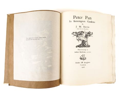
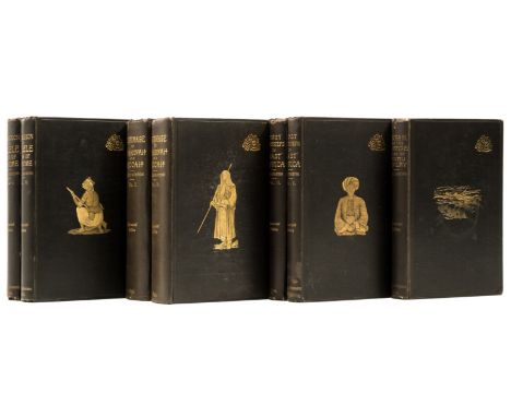
RACKHAM, Arthur (1867-1939, illustrator) - J. M. BARRIE. Peter Pan in Kensington Gardens, London, 1906, 4to, 50 mounted coloured plates by Arthur Rackham, original pictorial vellum gilt. FIRST RACKHAM EDITION, ONE OF 500 COPIES SIGNED BY THE ARTIST.RACKHAM, Arthur (1867-1939, illustrator) - J. M. BARRIE (1860-1937). Peter Pan in Kensington Gardens. London: Hodder & Stoughton, 1906. 4to (275 x 225mm). Half title, illustration on title, 50 coloured plates by Arthur Rackham mounted on brown paper at the end. Original pictorial vellum gilt, front endpaper with a map of Kensington Gardens, top edges gilt, others uncut (a little bowed, lacks silk ties). FIRST RACKHAM "DE LUXE" EDITION, LIMITED TO APPROXIMATELY 500 COPIES SIGNED BY THE ARTIST, this copy unnumbered and with the printed statement of limitation scored through by the artist or publisher. Garland 33; Gettings p.112: "... its publication and quality was a sure sign that Rackham had arrived ..."; Hudson p.61; Latimore & Haskell p.27; Riall p.74.
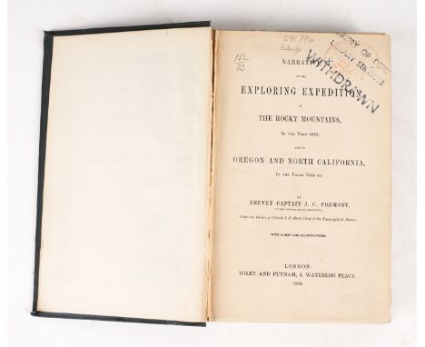
FREMONT, J. C. (1813-90). Narrative of the Exploring Expedition to the Rocky Mountains, London, 1846, 8vo, 4 lithographed plates, folding map, original cloth decorated in blind. FIRST U.K. EDITION. With 3 related works in 5 vols. (6)FREMONT, John Charles (1813-90). Narrative of the Exploring Expedition to the Rocky Mountains, in the Year 1842, and to Oregon and North California, In the Years 1843-44. London: Wiley and Putnam, 1846. 8vo (224 x 140mm). Lithographed frontispiece of "The American Falls of Lewis Fork," large folding "Map of the Western & Middle Portions of North America, to illustrate the History of California, Oregon & the other Countries on the North West Coast of America by Robert Greenhow," lithographed by Day & Haghe, 3 lithographed plates ("Hill of Columnar Basalt on the Columbia River," "Devil's Gate" and "Pyramid Lake"), tables (map torn without loss). Original dark blue/grey cloth stamped in blind with a design incorporating the American eagle on the upper cover, spine lettered in gilt (some very faint white staining). Provenance: From the Collection of the late Seymour Stein (1942-2023); "Ministry of Defence Library Services. Withdrawn" (stamps and library numbers on title, with faint stamp beneath, and library label at foot of spine); "Military Depot, Q.M.G. [Quarter Master General] Department" (label on front pastedown); "Bain Bookseller, 1 Haymarket" (small bookseller's label on front pastedown). FIRST U.K. EDITION. Despite being ex-library, this copy is in remarkably fresh and crisp condition, especially the folding map. Graff 1436; Howes F370; Sabin 25841; Streeter Sale 3132; Wheat Mapping the Transmississippi West 1540-1861 512. With 3 other related works in 5 vols., namely [Pierre de Sales Laterrière's] A Political and Historical Account of Lower Canada ... By a Canadian (London, 1830, 8vo, contemporary orange library buckram, ex-library copy, with stamps, FIRST EDITION), Henry Stuart Foote's Texas and the Texans; or, Advance of the Anglo-Americans to the South-West (Philadelphia, Thomas, Cowperthwaite & Co., 1841, 2 vols., 8vo, modern library buckram, ex-library copy, with stamps, FIRST EDITION) and Hochelaga, or, England in the New World. Edited by Eliot Warburton (London, 1846, 2 vols., 8vo, lithographed frontispiece of "Canadian Travelling", original cloth, head of spine of vol. II torn away, ex-library copy, with stamps, FIRST EDITION). The lot sold not subject to return. (6)
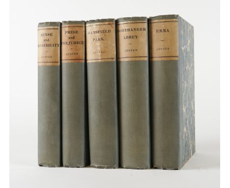
AUSTEN, Jane (1775-1817). The Novels, Oxford, 1923, 5 volumes, large 8vo, coloured frontispieces, original buckram-backed boards. ONE OF 1,000 SETS. (5)AUSTEN, Jane (1775-1817). The Novels. The Text based on Collation of the Early Editions by R. W. Chapman. Oxford: At the Clarendon Press, 1923. 5 volumes, large 8vo (225 x 145mm). Half titles, coloured frontispieces, frontispiece to "Mansfield Park" with flap, folding map at the end of "Sense and Sensibility", plates. Original blue-grey buckram-backed marbled boards, printed spine labels, uncut (some staining to labels). Provenance: Anthony Eden, 1st Earl of Avon (old armorial bookplate); loosely-inserted is a 2-page autograph letter, in pencil, on paper headed "Nawton Tower, Nawton, Yorkshire," [undated], stating, "Darling, well here I am marooned in the snow ...", possibly to Anthony Eden from his first wife Beatrice (indistinctly signed). ONE OF 1,000 SETS. (5)
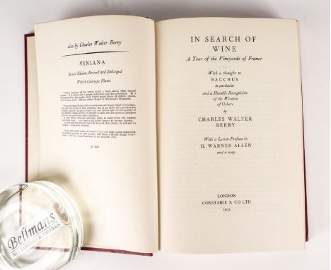
WINE - Charles Walter BERRY. In Search of Wine, London, 1935, original red buckram. FIRST EDITION, PRESENTATION COPY, inscribed to Anthony Eden. With 6 other books of related interest including 3 PRESENTATION COPIES inscribed to Anthony Eden. (7)WINE - Charles Walter BERRY (dates unknown). In Search of Wine. A Tour of the Vineyards of France. With a thought to Bacchus in particular and a Humble Recognition of the Wisdom of Others. London: Constable & Co Ltd., 1935. 8vo (195 x 130mm). Half title, large folding map of "The Wine Districts of France" at the end. Original red buckram, spine lettered in gilt (spine faded, without a dust-jacket). Provenance: Anthony Eden, 1st Earl of Avon (old armorial bookplate). FIRST EDITION, PRESENTATION COPY, the front free endpaper inscribed, "To Captain The Rt. Hon. R. Anthony Eden ... with the compliments & respect of the author, who when he read your kind letter of appreciation felt that all the work entailed (mentally & physically) was amply justified - + more so. Charles Berry. Flow Wine! Smile Woman! And the Universe is consoled!! 3.XII.35." With 6 other books of related interest including the same author's Viniana (London, "reprinted 1934", 8vo, original red buckram, PRESENTATION COPY, the front free endpaper inscribed, "To The Rt. Hon. R. Anthony Eden ... with the author's thanks for the privilege. The old proverb says, An apple a day keeps the doctor away (to which the author would wish to add) for a day. But a glass of good wine for a very long time, so they say. Charles Berry, 8/11/36"), the same author's Tokay (London, Berry Bros. & Co., [n.d.], original buckram-backed boards, with a typed compliment slip from Mr Anthony Berry pasted to the front free endpaper, addressed to Anthony Eden, dated 28.5.76, stating, "I thought that you would like to have a bottle of the Tokay Essence following our telephone conversation last week and this is therefore being sent to you under separate cover. However, I am enclosing a copy of my uncle, Charles Walter Berry's booklet, which he wrote before the War. Please accept the bottle with the best wishes of us all here. Enc.") and Hugh R. Rudd's Hocks and Moselles (London, 1935, original cloth, FIRST EDITION, PRESENTATION COPY, with an inscription by the author to Anthony Eden including a biblical 'quote' ("... 'He restored the chief butler unto his butlership again ... But he hanged the chief baker.' Genesis XL. 21")). Provenance: Anthony Eden (five of the books with his old armorial bookplate). (7)
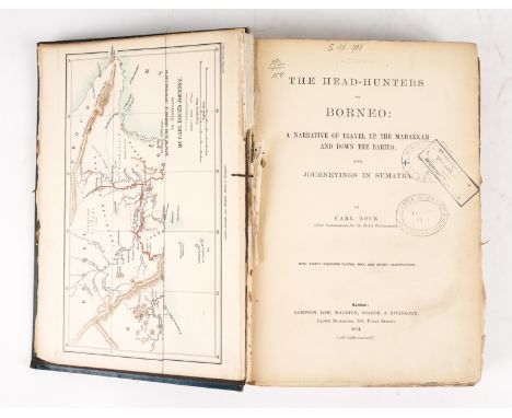
BOCK, Carl (1849-1932). The Head-Hunters of Borneo, London, 1881, large 8vo, folding map, 30 lithographed plates, of which 28 coloured, illustrations (some staining), original coloured pictorial cloth gilt (partly disbound). FIRST EDITION.BOCK, Carl Alfred (1849-1932). The Head-Hunters of Borneo: A Narrative of Travel up the Mahakkam and Down the Barito; Also, Journeying in Sumatra. London: Sampson Low, Marston, Searle, & Rivington, 1881. Large 8vo (262 x 180mm). Half title, folding engraved map of South East Borneo printed in colours, 30 lithographed plates by C. F. Kell after the author, of which 28 coloured, illustrations, tables (map and many plates and text leaves detached or loose, some mainly marginal spotting, staining and browning). Original pictorial cloth gilt, uncut, brown endpapers (rubbed, upper joints split at head, scuffed and stained, partly disbound). Provenance: From the Collection of the late Seymour Stein (1942-2023); "War Office Library"; "Quarter M[aster] G[eneral]'s Dept. Intelligence Branch" (2 stamps on title, with "Ministry of Defence. Withdrawn from Stock" stamp over the former). FIRST EDITION. Bobins The Exotic and the Beautiful 282.
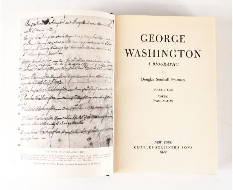
FREEMAN, Douglas Southall (1886-1953). George Washington, New York, 1948-51, volumes I-IV only (of VI), original cloth. FIRST EDITION, PRESENTATION COPY, inscribed by the author to Anthony Eden. With 2 other works by the same author in 6 vols. (10)FREEMAN, Douglas Southall (1886-1953). George Washington. A Biography. New York: Charles Scribner's Sons, 1948-51. Volumes I - IV only (of VI), large 8vo (231 x 155mm). Half titles, half tone plates, maps. Original dark blue cloth gilt, map endpapers (without slipcases). Provenance: Anthony Eden, 1st Earl of Avon (modern armorial bookplate loosely-inserted). FIRST EDITION, with 'A' on the copyright page of each volume, of the work for which the author won his second (posthumous) Pulitzer Prize in 1958. After the fifth and sixth volumes (not present here), a seventh, written by John Alexander Carroll and Mary Wells Ashworth, but based substantially on Freeman's research and notes, was published in 1957. PRESENTATION COPY, the half title of the first volume inscribed, "Autographed for The Right Honorable Anthony Eden in admiring gratitude for his service in advancing those interests of English-speaking peoples that Washington revered. Douglas Southall Freeman, July, 1950." It is clear, from the date of the inscription, that the author presented Anthony Eden with the first four volumes only (the fourth volume dated 1951 presumably being first issued in 1950), as are present here. Loosely-inserted in the second volume is a clipping from the Swindon Advertiser (Oct. 12th, 1959) featuring an opinionated and amusing letter relating to Anthony Eden and the Suez Crisis from one G. Rogers, marked [?by Eden] with two pencil crosses. With the same author's R. E. Lee. A Biography (New York, 1937, 4 vols., large 8vo, original red cloth, a reprint of the work for which the author won his first Pulitzer Prize in 1935, old armorial bookplate of Anthony Eden) and Lee's Lieutenants. A Study in Command (New York, 1942-43, 2 vols., original black cloth, FIRST EDITION, with Anthony Eden's modern armorial bookplate loosely-inserted). (10)

PINE, John (1690-1756). A Chart shewing the Several Places of Action between the English and Spanish Fleets, London, 1739, fine hand-coloured engraved map with elaborate border (very lightly browned and spotted at centrefold), 370 x 592mm., unframed.PINE, John (1690-1756), Hubert-François GRAVELOT (1699-1733) & Clement LEMPRIERE (1683-1746). A Chart Shewing the Several Places of Action between the English and Spanish Fleets, with the Places where Several of the Spanish Ships were Destroyed in their Return to Spain, North about the British Islands. [London:] John Pine, 1739. Fine hand-coloured engraved map of the British Isles by John Pine and Hubert-François Gravelot after Clement Lempriere within elaborate decorative border, blank on verso (very lightly browned and spotted at centrefold), 370 x 592mm., unframed. The border of the map is particularly dramatic, filled with battling allegorical figures in various states of disarray and forked lightning, and with illustrations of sea-battles in roundels. The engraving is taken from Pine's The Tapestry Hangings of the House of Lords Representing the Several Engagements between the English and Spanish Fleets (London, 1739) which reproduced tapestries commissioned in 1591 to celebrate the defeat of the Spanish Armada. Pine's publication proved particularly fortuitous: the original tapestries on which it was based were completely consumed in the fire which destroyed the Palace of Westminster in 1834. "In 1739 Pine published 'The Tapestry Hangings of the house of Lords ...' with portraits, charts of the coasts of England, medals, &c. As these valuable tapestries, executed by H. C. Vroom to commemorate the defeat of the Spanish armada, were subsequently destroyed by fire, Pine's engravings, done from drawings by C. Lempriere, are of the greatest historical value" (DNB).
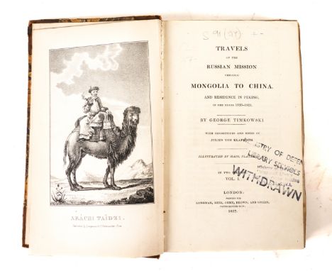
TIMKOWSKI, Egor Fedorovitch (1790-1975). Travels of the Russian Mission through Mongolia to China, London,1827, 2 volumes, 8vo, frontispiece, folding map, plan of Peking, old half calf. FIRST U.K. EDITION. With 2 other related works in 3 vols. (5)TIMKOWSKI, Egor Fedorovitch (1790-1975). Travels of the Russian Mission through Mongolia to China, and Residence in Peking, in the Years 1820-1821 ... With Corrections and Notes by Julius Klaproth, translated by H. E. Lloyd. London: Printed for Longman, Rees, Orme, Brown, and Green, 1827. 2 volumes, 8vo (214 x 135mm). Lithographed frontispiece, large folding "Map of the Route from Kiakhta to Peking, through Mongolia", folding plan of Peking. Contemporary half calf and marbled boards, spines gilt with black morocco lettering-pieces (heavily rubbed and scuffed). Provenance: "Ministry of Defence. Withdrawn" (stamps on front free endpapers, title, map of Peking and at margin of one text leaf; library labels at foot of spines with library numbers written in white ink on corner of upper covers). FIRST U.K. EDITION. Brunet IV, 483; Löwendahl 859; Lust 550. With 2 other related works in 3 vols., namely Frederick E. Forbes' Five Years in China; from 1842 to 1847. With an Account of the Occupation of the Islands of Labuan and Borneo by Her Majesty's Forces (London, 1848, 8vo, fine coloured lithographed frontispiece of "The Empress of China", illustrations, original mustard yellow cloth, FIRST EDITION, ex-library copy, with the same provenance and similar related condition issues as with the first named item) and Sven Hedin's Trans-Himalaya. Discoveries and Adventures in Tibet (London, 1909, 2 vols., plates, attractively-bound in contemporary blue full prize calf gilt, FIRST EDITION). Provenance: From the Collection of the late Seymour Stein (1942-2023). (5)
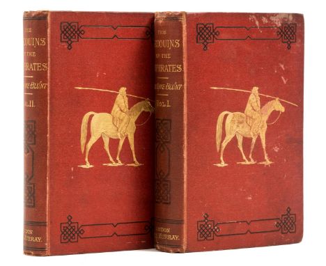
Middle East.- Blunt (Lady Anne) Bedouin Tribes of the Euphrates, 2 vol., first edition, half-titles, wood engraved frontispieces and 10 plates, 1 folding colour map, 1 folding pedigree of Arabian thoroughbreds, advertisements at end vol. 2, scattered faint spotting, bookplate of Peter Hopkirk, original pictorial cloth, gilt, very slight mottling, slight bumping to corners and extremities, 8vo, 1879.⁂ Lady Anne Blunt (1837-1917) was the daughter of Ada Lovelace, and granddaughter of Lord Byron. She was the co-founder of the Crabbet Arabian Stud, along with her husband, the poet Wilfrid Blunt. They travelled extensively in Arabia and the Middle East in order to buy Arabian horses, to bring back to England.
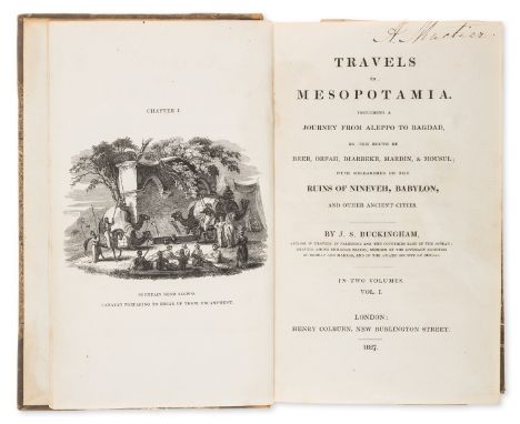
Buckingham (James Silk) Travels in Mesopotamia. Including a Journey from Aleppo to Bagdad, by the route of Beer, Orfah, Diarbekr, Mardin, & Mousul, 2 vol., first octavo edition, folding engraved map, 2 double-page lithograph plates, 27 wood-engraved plates, contemporary half calf, rubbed, vol.1 upper cover detached, 8vo, 1827.⁂ The Cyrus Ghani copy with ink inscriptions dated 1951 to front free endpaper vol.1. Also bookplate and inscription of Anthony MacTier of Durris.
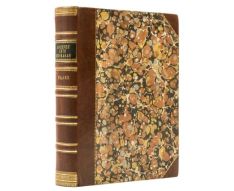
Fraser (James Baillie) Narrative of a Journey into Khorasan, first edition, folding engraved map, short tear to title, errata slip, ink stamp to map verso, title and final leaf, modern half calf over marbled boards, [Ghani p.140; Wilson p.75], 4to, 1825.⁂ Provenance: American Museum of Natural History (ink stamps).
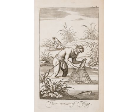
Fryer (John) A New Account of East-India and Persia, first edition, half-title with engraved portrait on verso, title printed in red and black, 7 engraved plates and maps, 3 folding, and one full-page engraved map in text with printed slip pasted below, engraved or woodcut illustrations, Ss1 with marginal repaired tear, some light foxing and browning, contemporary panelled calf, rubbed, spine ends chipped and joints starting, [Wing F2257], folio,Printed by R[obert] R[oberts] for Ri. Chiswell, 1698.⁂ In 1672 Fryer embarked on a 10-year tour to India, Goa, the Arabian Gulf and Persia, before returning to England. The work includes a detailed account of Surat and Muscat and mentions pirates in the Gulf, and the natural history of the region.
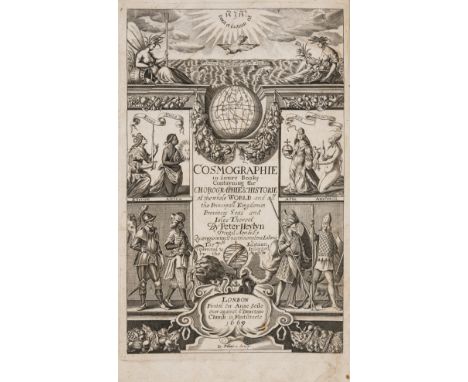
Heylyn (Peter) Cosmography in Four Books. Containing the Chorography and History of the whole World, 4 parts in 1 vol., engraved additional title dated 1669, printed title in red and black, 4 double-page engraved maps of Europe, Asia, Africa, and America, some with tears at folds, with initial imprimatur f., a few burn-holes, occasional worming to margins and very slightly affecting map of America, some light staining, contemporary calf, rebacked, rubbed, [Sabin 31655; Wing H1694A], folio, Printed for Philip Chetwind, and Anne Seile, 1674.⁂ A variant of the edition with letter-press imprint "printed for Anne Seile, and Philip Chetwind" and engraved imprint "printed for Philip Chetwind" (Wing H1694).
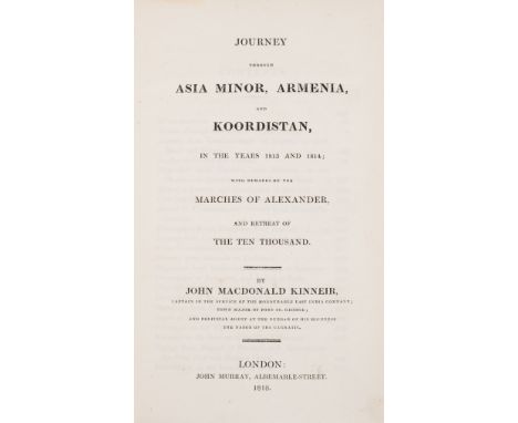
Kinneir (John Macdonald) Journey through Asia Minor, Armenia, and Koordistan, first edition, half-title, large folding engraved map with hand-coloured routes, with slight tear, marginal repair to fore-edge of following leaf of text, some light browning, contemporary calf, gilt, rubbed, upper cover detached, [Blackmer 914; Weber I, 55; cf. Atabey 636 (French edition only)], 8vo, 1818.⁂ The Peter Hopkirk copy. Kinneir was attached to Sir John Malcolm's mission from India to Persia in 1808-9, acting as an agent at Bushire and making numerous journeys within Persia. In 1810 he went back to England but returned to India in 1813-14 by way of Cyprus, Constantinople, Baghdad and Bombay. It is this latter journey that is recounted here, though his earlier travels in Persia are also listed (p.552).Provenance: Thomas Thomas Jr (ink inscription dated 1818 on front endpaper); Peter Hopkirk (bookplate, his sale at Sotheby's 14 October 1998, lot 907).
Malcolm (Col. Sir John) The History of Persia, 2 vol., first edition, half-titles, folding engraved map and 22 plates, some light foxing and offsetting, contemporary russia, stamped in blind and gilt, corners and spine raised bands rubbed, but still a handsome copy, [not in Atabey or Blackmer], 4to, 1815.⁂ A handsome copy of this important and comprehensive history of the region.
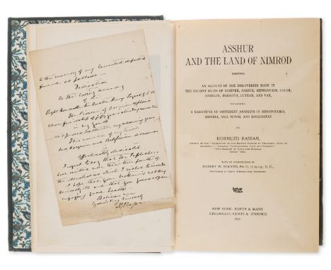
Middle East.- Rassam (Hormuzd) Asshur and the Land of Nimrod, first edition, association copy with 2pp. A.L.s from the author to Lady Layard loosely inserted, frontispiece, plates, 2 folding plans, 1 double-page map, patterned endpapers, bookplate, original cloth, slight bumping to corners and extremities, 8vo, New York & Cincinnati, 1897.⁂ Provenance: Bookplate of Peter Hopkirk. A.L.s from the author addressed to Lady Layard dated 1898, discussing the publication of this book and transcribing his full dedication to Lady Layard's late husband, A. H. Layard. "I have dedicated it to the memory of my lamented departed friend as follows ..."
Wittman (William) Travels in Turkey, Asia-Minor, Syria, and across the desert into Egypt, first edition, folding engraved frontispiece, folding map, 21 plates (16 hand-coloured, one folding), plan supplied in facsimile, some foxing and offsetting, contemporary tree calf, gilt, a little rubbed, [Atabey 1344; Blackmer 1832; Weber 647; not in Abbey or Colas], 4to, 1803.⁂ "Wittman was a member of the Anglo-Turkish expeditionary force which travelled overland from Constantinople to Egypt in 1799 to take part in the campaign against the French." (Atabey).Provenance: Pardo de Lygonier (cypher to covers and spine, bookplate); Teodoro Callimachi (bookplate); Sefik E. Atabey (bookplate). The missing/facsimile plan is not mentioned in the Atabey catalogue.
Africa.- Burton (Sir Richard Francis) "The Memorial Edition" of The Works, 7 vol., half-titles to all but vol. 2, plates, most tinted or chromolithographs, 1 folding colour map, 5 plans of which 3 folding, occasional faint spotting, vol. 5 with bookplate, vol. 7 with previous owner's ink signature and ink-stamp to early leaves, cracked hinges, original pictorial cloth, a little rubbed, slight chipping to corners and spine extremities, [Penzer pp.54-55; 64-65; 73-74 and 82-83], 8vo, 1893-94.⁂ Vol. 1 of "First Footsteps in East Africa" (vol. 6) has an error in the list of illustrations. 'The Fal' is listed as an illustration, despite never having been added to either this or earlier editions of the same.
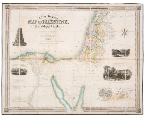
Holy Land.- Creighton (Robert) A New Historical Map of Palestine with Part of Egypt & Arabia..., map of the Holy Land including the mouth of the Nile River and part of Arabia, with inset plans and vignettes, and showing part of the old Roman road that leads to Mecca, engraving with vibrant original hand-colouring, 835 x 1055 mm (32 3/4 x 41 1/2 in), dissected and mounted on linen, light offsetting with very minor browning and surface dirt, folding with dark blue morocco ends and the book plate of Augustus Terry Clarke, map edged with blue linen, folding into slipcase, gilt title 'Palestine' to spine, rubbed and scuffed with with splitting to spine, 8vo, Henry Teesdale, 1838.
![Holy Land.- Jacob (Abraham bar) [Map of the Holy Land from: Seder Haggadah Shel Pasah / The Passover Haggadah], oriented with](https://cdn.globalauctionplatform.com/175e1d27-5155-4863-91f2-b02a010cc1cf/d281e9c9-9e09-40cb-98c4-b02a01181206/468x382.jpg)
Holy Land.- Jacob (Abraham bar) [Map of the Holy Land from: Seder Haggadah Shel Pasah / The Passover Haggadah], oriented with north to the left and the Mediterranean in the lower half, with the Promised Land in the upper half of the sheet, showing the route of the Exodus, the 41 encampments of the Israelites listed within ornate scroll-work cartouche alongside biblical vignettes including Jonah and the whale, extensive Hebrew text printed throughout, engraving, on fine laid paper with watermark of foolscap and large Arms of Amsterdam, sheet 285 x 505 mm (11 1/4 x 19 7/8 in), old folds as issued, some repairs to splitting, repaired tears at the right right edge running into the map, small marginal losses restored, minor surface dirt, 1695⁂ Rare example of the earliest engraved map of the Holy Land with Hebrew text. Originally created for a Haggadah first printed in 1695, considered a seminal moment in the history of Hebrew printing and illustration, Jacob's map is based on the cartography of Van Adrichom.

South East Asia.- Ortelius (Abraham) Indiae Orientalis Insularumque Adiacientium Typus, early map of the East Indies based on Mercator's world map of 1569, engraving with hand-colouring, on laid paper with small heart watermark, platemark 350 x 495 mm (13 3/4 x 19 1/2 in), good margins, French text verso, some minor spotting and browning, unframed, [circa 1575 or slightly later].
Sri Lanka.- Knox (Robert) An Historical Relation of the Island Ceylon, in the East-Indies, first edition, title within double-rule border, engraved folding map and 15 plates, one with repaired tears, licence f. before title, without the portrait (as usual), advertisement f. at end, the odd spot or burn-hole, some marginal browning and staining, later calf, worn, upper cover and licence leaf detached, lower cover almost so, [Wing K742], folio,Printed by Richard Chiswell, Printer to the Royal Society, 1681.⁂ The first account of Sri Lanka in English, and one of the sources for Defoe's Robinson Crusoe. While sailing for Persia in 1658, Knox's ship lost its mast in a storm and was forced to put ashore on Ceylon. Knox, along with his father [not elder brother] and crew, was captured by King Rajasinha II of Kandy and refused permission to leave the kingdom. Knox and a companion eventually escaped after 19 years of captivity and fled to a Dutch fort in the north of the island.Provenance: Frederick Lock (bookplate and ink name on verso of licence leaf).
London.- Maitland (William) The History of London, first edition, double-page folding map frontispiece, slight fraying at edges just touching image, 24 engraved plates and plans (3 double-page), engraved illustrations, list of subscribers, slight frayed edges at beginning and end, only affecting margins, scattered faint spotting, bookplate to final pastedown, contemporary calf, rebacked rubbed and worn, bumping to corners, folio, 1739.
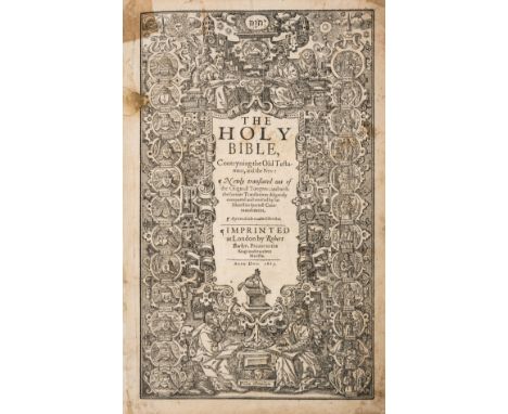
Bible, English. The Holy Bible, Conteyning the Old Testament and the New, black letter, text in double columns, in 72 lines, within ruled border, general and NT titles within ornate woodcut borders, calendar in red and black, woodcut decorations and initials, Speed's Genealogies inserted before Genesis, lacking final 2 ff., including double-page map, general title with small paper repair at inner margin (just affecting woodcut border), 3 ff. with small defects affecting text with loss of letters from a few lines (2Y1, 3I3 & 4G3), 3Z1 & 4G1 soiled, 4N4 laid down to sheet (final f.), trimming to top edge, often affecting ruled border and headlines, some instances of light damp-staining, nineteenth century blind-stamped calf, spine a little scuffed, brass clasps, [STC 2226; Herbert 322], folio, Robert Barker, 1613⁂ A remarkably clean and complete copy of "the true folio edition of King James' Bible; easily distinguishable form the other large folio editions by its smaller type" (Herbert p.138)Provenance: Stephen Drake Freer [bookplate, Eton College prize label dated 1938]
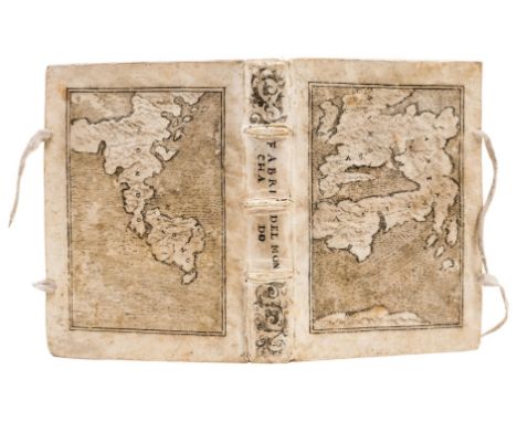
Anania (Giovanni Lorenzo d') L'Universale Fabrica del Mondo, overo Cosmografia, collation: Ϯ8 ϮϮ4 a-d4 A-Z Aa-Zz Aaa-Ccc4 Ddd6 (lacking final blank leaf Ddd6), woodcut printer's device on title, 5 engraved maps (one double-page, the rest folding), woodcut head-pieces and initials, damp-staining, some repairs to worming in first few leaves slightly affecting a few letters (including title), contemporary limp vellum decorated by Cesare Vecellio with original drawings in pen and ink, depicting map of Europe and Asia on upper cover and map of Americas "Mondo novo" on lower cover, spine lettered vertically and with scroll design, marbled edges, leather ties renewed, 4to (220 x 160mm.; binding 225 x 170mm.), Venice, Presso il Muschio, 1582.⁂ A stunning copy of Anania's important cosmography, with an exceptional provenance. The maps depict Europe, Asia, Africa and the Americas plus a twin-hemisphere world map.Originally owned by the great bibliophile Odorico Pillone (1503-1593) , of Belluno. In 1580 Pillone famously commissioned the painter Cesare Vecellio (1521-1601) to decorate, with drawings or painted fore-edges, the bindings of 172 volumes preserved in his Villa Casteldardo in the Dolomites, in which he had established his studio. Vecellio, was a cousin and pupil of Titian, and worked in his atelier until his death. The present example represents one of only 21 volumes that Vecellio adorned with drawings on the covers.Provenance: Odorico Pillone (1503-1593; cover drawings); Sir Thomas Brooke (1830-1908; bookplate; sold by his heirs in 1957 to Pierre Beres); J.R. Abbey (bookplate; sale Sotheby's 21 June 1967, lot 2091).Literature: Bibliotheque Pillone 132; Sabin 1364; Cordier, Bib. Sinica, I:5.
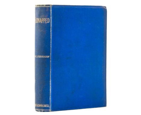
Stevenson (Robert Louis) Kidnapped, first edition, first issue, half-title, folding colour map, 16pp. publisher's catalogue at end, slight spotting to title and elsewhere, original blue cloth, spine lettered in gilt, slight rubbing to joints and some shelf-lean, 8vo, 1886.⁂ A very good copy with the following issue points: with "business" instead of "pleasure" on p. 40, line 11, "nine o'clock" instead of "twelve o'clock" on p. 64, line 1, and "Long Islands" instead of "Long Island" on p. 101, lines 9/10. Additionally the publisher's catalogue is dated "5G.4.86" and "5B.4.86".
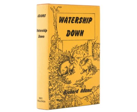
Adams (Richard) Watership Down, first edition, signed presentation inscription from the author "To Jessie and Derek Hinich with best wishes from Richard Adams January 1973" on front free endpaper, folding map at end, original cloth, dust-jacket, very light surface scuff to spine head, otherwise remarkably fine, 8vo, 1972.⁂ Inscribed to friends of the author, Adams knowing the recipient Derek through their positions in the Department of Environment in the Civil Service.
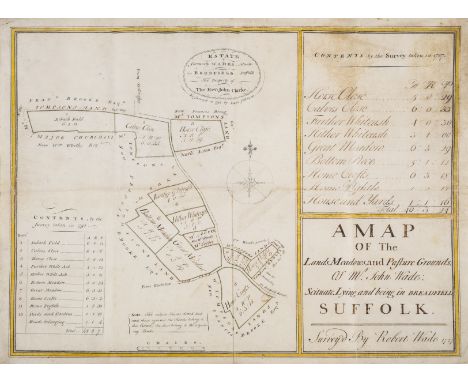
Suffolk Estate map, Bredfield.- Johnson (Isaac, surveyor & artist) A Map of the Lands, Meadows, and Pasture Grounds of Mr. John Wade Situate, Lying and being in Breadfield Suffolk... Estate formerly Wades... The Property of Rev John Clarke, manuscript estate map in pen and ink and outlined in yellow watercolour wash, on vellum, folds, "Survey'd By Robert Wade 1727... Re-survey'd in 1797", 430 x 540mm., 1797; and another by Johnson, a plan of an estate in Woodbridge, on paper, a few small holes, 1795, v.s., v.d. (2).⁂ First mentioned Bredfield, two miles north of Woodbridge.
![John Speed, Map of the Countye of Monmouth. Monmouth. Speed (John), Denbighshire, Thomas Bassett and Richard Chiswell, [1676]](https://cdn.globalauctionplatform.com/17fa8891-09b7-4efd-9fba-b02000b6d58b/839125f0-4dfe-40c4-9c30-b03301182730/468x382.jpg)
![John Speed, Map of Pembrokeshire. Pembrokeshire. Speed (John), Pembrokeshire, John Sudbury and George Humbell, [1614], hand-c](https://cdn.globalauctionplatform.com/17fa8891-09b7-4efd-9fba-b02000b6d58b/17de4894-775c-424e-9298-b033011827f0/468x382.jpg)
![Johannes Jansson (1588-1664), Map of Lancashire. Lancastria. Jansson (Johannes), Lancastria, [1636], hand-coloured engraved m](https://cdn.globalauctionplatform.com/17fa8891-09b7-4efd-9fba-b02000b6d58b/59311e28-c1dc-4ed8-9ee9-b033011828be/468x382.jpg)

A quantity of Westminster Philatelic Classics to include The 1849 20c Ceres Black stamp, The United States 5c Benjamin Franklin stamp, The British Empire Exhibition Wembley, The Official overprinted stamps collection, The 1972 Machin Imperforate pair, all in original folders with COAs, a Penny Black and a 1913 Australian Kangaroo and Map in sealed plastic capsule (7)

AFTER D. SMITH, 'Osborne's Map of the Grand Junction Railway' engraving, 33.5cm x 60cm, published by E.C. & W. Osborne, Birmingham 1838, in later wooden frameProvenance: The Estate of the late John Rollo Somerset-Paddon, formerly of Chalk Newton House, Maiden Newton, Dorset, thence by descent.


The Youth International Party's members, the "Yippies", were part of the 1960's counterculture movement. They created this poster with the map of the USA and a street map of Miami Beach to coincide with the Democratic and Republican conventions were they held protests against both parties. Issued: 1972Dimensions: 22"L x 28"HCountry of Origin: United StatesCondition: Age related wear. As found, creases from folding.

Magazine depicting black and white exterior photographs and descriptions of attractions within the World's Fair. The theme for the 1939 World's Fair was the "Building the World of Tomorrow." Attractions of note: General Motors Corporation, Hall of Pharmacy, The Borden Company, and Railways. Includes map of fairgrounds. Total pages: 48. Issued: 1939Dimensions: 12"L x 9.5"WCountry of Origin: United StatesManufacturer: Quality Art Novelty Company, Inc.Condition: Age related wear. Minor water damage.


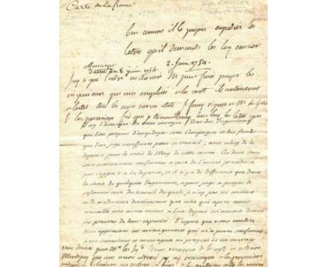
CASSINI JACQUES: (1677-1756) French astronomer. A.L.S., Cassini, two pages, 8vo, Paris, 31st May 1754, to a gentleman, in French. Cassini sends his correspondent a statement of engineers who are proposed to be employed along with the funds deemed necessary for the work, explaining 'Les deux etats sont entierement conformes a ceux de l'annee precedente par rapport a la depense, et il n'y a de difference que dans le choix de quelques ingenieurs, ayant juge a propos de reformer ceux du travail desquels je n'ay pas ete content et de n'admettre dorenavant que ceux qui apres avoir travaille une annee entiere a leur depens m'auront donne des preuves de leur capacite. J'espere que vous voudrez bien approuver cet arrangement qui m'a paru conforme a vos intentions et avantageux au progres de cet ouvrage de meme qu'a sa perfection' (Translation: 'The two statements are entirely in conformity with those of the preceding year in relation to the expense, and there is no difference except in the choice of a few engineers, having judged fit to reform those of whose labour I was not happy and to admit from now on only those who, after having worked for a whole year at their expense, will have given me proof of their capacity. I hope that you will agree to approve this arrangement which seemed to me to be in conformity with your intentions and advantageous to the progress of this work as well as to its perfection'), further referring to some books and court proceedings against certain engineers who refused particular orders and concluding by remarking 'On m'a apporte hier au soir la premiere epreuve de la carte des environs de Montigny que j'ai cru devoir vous envoyer afin que vous puissiez l'examiner a vos moments de loisir' (Translation: 'I was brought yesterday evening the first proof of the map of the surroundings of Montigny which I thought I should send to you so that you could examine it at your leisure'). Cassini's correspondent has penned a response, of just over ten lines dated 8th June 1754, to the upper and lower areas of the first and second pages. Some light foxing and minor age wear, largely to the edges, about VG

BARTHROPP PADDY: (1920-2008) British Wing Commander, a fighter pilot and flying ace who participated in the Battle of Britain during World War II. From 1942-45 Barthropp was a German Prisoner of War, spending some time at Stalag Luft III and contributing to the 'Great Escape'. Small selection of signed printed images, photocopies etc. of various sizes (8 x 11.5 and smaller) some neatly removed from books or magazines, the different images depicting Barthropp in uniform poses and one showing various pieces of World War II memorabilia associated with the pilot including his escaper's silk map of Germany, cutlery from Stalag Luft III, miniature medals etc. All are signed in ink or pencil, some with additional comments or inscriptions etc. Also including a signed and inscribed hardback edition of Paddy - The Life and Times of Wing Commander Patrick Barthropp DFC AFC, First Edition published by J & KH Publishing, Hailsham, 2001. Signed and inscribed by Barthropp to the front free endpaper, 'A few tales from a long time ago when cigarettes were 10p for 20. Our pay was 68p a day & some clown hadn't invented counsillors (sic)'. Generally VG, 5


"Oarsman's and Angler's Map of the River Thames...", 1 vol, James Reynolds, tooled binding, no text just fold-out map, Mitton, G E: "The Thames", 1 vol illust, Mempes A & C Black, 1906, Leslie George: "Our River", 1 vol, Bradbury, Agnew & Co, 1888, and Leyland, John, "The Thames Illustrated", 1 vol, Geo Newnes (all uncollated)
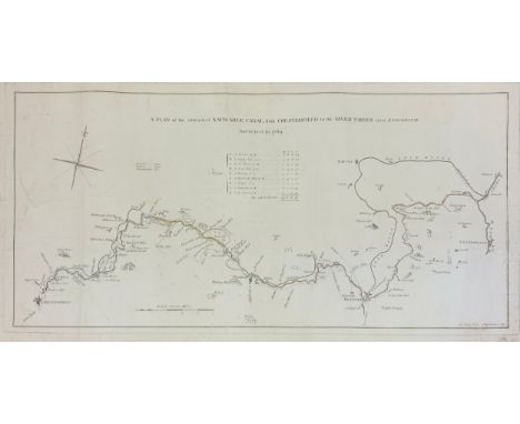
A Plan of the intended Navigable Canal from Chesterfield to the River Trent near Stockwith, surveyed in 1769, 80cm long, 38cm wideThis one is very similar to the 1769 John Varley map ending up in Gainsborough. Both were engraved by Thomas Kitchin.The map, more or less, the actual route adopted.This is much larger than other maps. (The map itself is 800 mm x 380 mm; the piece of paper is 950 x 490.) This means that it has more detail than other maps.An intriguing feature is a series of numbers. These go from 1 (at Chesterfield) to 174 (at West Stockwith). They are not evenly spaced. They are very crowded together in Chesterfield and very spread out near Osberton.Christine Richardson (historian) writes:“The numbers on the maps are packets of land, usually in that era called ‘Closes’, each having a name. The relevance to the canal is that different landowners are involved, some of whom agree with building a canal through their land, others who don’t. They are more tightly packed in areas where there are more people and ‘closes’ have probably been divided on the owner dying. In rural Nottinghamshire the ‘closes’ are still larger in size.There was originally a book, produced by the Canal Company, identifying the numbers on the maps to ownership. But, unfortunately, that book has yet to come to light, or has been destroyed.It was all relevant during the application for the Act of Parliament, with the Canal Company having to prove, to the owners and Parliament, through whose land they were going to build the canal.”Provenance: originally owned by Yorkshire Archaeological Society who were downsizing their library.
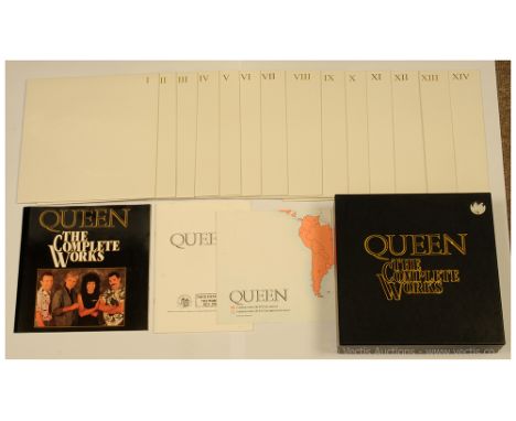
Queen, The Complete Works (QB1) - 1985 UK box set containing 14 LPs to include Queen, Queen II, Sheer Heart Attack, A Night At The Opera, A Day At The Races, News of The World, Jazz, Live Killers (Volume 1), Live Killers (Volume 2), The Game, Flash Gordon, Hot Space, The Works and Complete Vision. Includes The Complete Works Booklet, Tour Itinerary The World 1971-1985 Booklet and Queen World Map. All records are overall Excellent (and appear unplayed) other than Complete Vision which is only Good Plus to Very Good in Excellent embossed carded outer sleeves, outer presentation box is generally Very Good Plus (with remainder of original price sticker to one corner). A superb item.


-
109198 item(s)/page