We found 109182 price guide item(s) matching your search
There are 109182 lots that match your search criteria. Subscribe now to get instant access to the full price guide service.
Click here to subscribe- List
- Grid
-
109182 item(s)/page


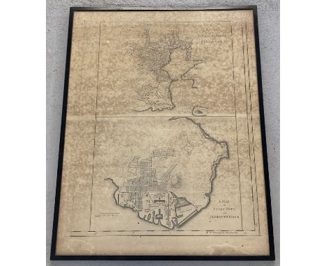
![An old framed map 'Plan of the City Castle and Suburbs of Edinburgh' [Frame 23x31.5cm]](https://cdn.globalauctionplatform.com/1ad89cfa-a062-4d09-9b80-abc300e0420d/605ecc68-a05c-42d0-ac71-abc400094243/468x382.jpg)
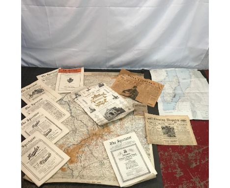
Lot 595D
A Collection of early and mid 1900's magazines, ordnance maps, newspapers and certificate. Includes WW1 Remembrance certificate to Fleming, Rfn. John, 52164. 15th Bn. Royal Irish Rifles. Scottish Daily Express dated 1943 and Evening Dispatch dated 1945. Together with a collection of 'The Spectator' magazines dated 1926. Ordnance map dated 1917 showing Progress in the YPRES Areas.
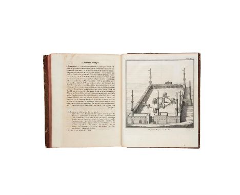
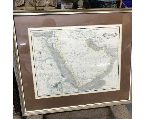
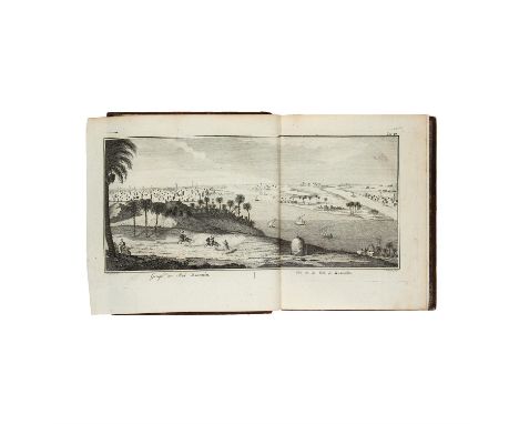
Lot 2
Ɵ C. Niebuhr, Description de L'Arabie d'apres les observations et recherches faites dans le pays meme, by Nicholas Möller [Copenhagen, 1773]single volume, complete, half-title, title and dedication with engraved vignettes, large folding engraved map of Yemen with colour addition, 25 engraved plates and maps (9 of these folding and 2 with coloured additions), errata leaf at the end, some very light offsetting and faint darkening to some leaves, overall clean and crisp condition, "Adolpho Burgery" inscription to front free endpaper and bookplate of Carlos Alberto Ferreira da Costa to upper pastedown, 4to (255 by 200 mm); contemporary quarter mottled calf, extremities rather scuffed, upper board detached, edges stained red
Lot 3
Ɵ C. Niebuhr, Voyage en Arabie & en d'autres pays circonvoisins, translated from German to French, in two volumes, by S. J. Baalde and J. Van Schoonhoven & comp. [Amsterdam and Utrecht, 1776-1780]2 volumes, complete, half-titles and dedication with engraved vignettes, engraved head- and tail-pieces, volume I with 72 engraved plates and maps (many of these large and folding) and one large folding map of Yemen with additions in colour, volume II with 52 engraved plates and maps (many of these folding), some occasional browning and a few scattered spots, bookplates of Carlos Alberto Ferreira de Costa and R. Felner to pastedowns, 4to (270 by 220 mm.); contemporary calf, covers ruled in gilt, spines gilt in compartments with red morocco labels, both volumes a little scuffed, spines rebacked, lower board of first volume detached
Lot 31
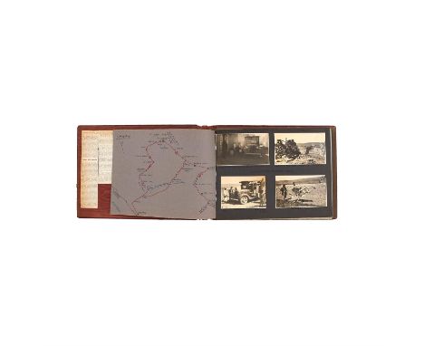
Ɵ Yemen in 1937 and 1938, documented by Italian traveler B.V. Clementi, two albums of black & white photography with manuscript annotations and captions [Yemen, 1937-38] two photograph albums comprising of over 300 original black and white photographs mounted on 36 leaves, with 12 duplicate photographs in envelopes pasted onto rear pastedowns, individual captions in blue ink for most of the images, images numbered (sometimes on photograph) in blue, manuscript map of routes taken around Yemen tipped onto first leaf of each album, newspaper cuttings from 1968 pasted onto front pastdown, original tissue-guards protecting the pages, typed letters from the owner B.V. Clementi about the collection mounted to the first page of each volume, albums each c. 245 by 315mm.These photographs are an extraordinary record of the history and society of Yemen in the early twentieth century taken by an Italian enthusiast on his travels in the region from 1936 to 1938. However the majority of the photographs in these two albums were taken in and around Sanaa, the capital of Yemen at the time. The subjects of the photos are diverse and wide ranging, from local people shopping and working in markets, farming animals and working the land, historical landmarks including an abandoned eighteenth-century fortress, religious festivals, and a range of nationalities and religions including German, Polish, Jewish, Somalian, English, Arab, and sheikhs.The albums are also highly personal, with photos featuring Clementi himself in his home in Sanaa welcoming guests, taking part in leisurely activities such as golf and tennis, and even celebrating Christmas. It is clear that Clementi was interested and invested in his surroundings and the people he met on his travels, as many of the captions identify people by their names and occupations, and range from his staff, to local people, as well as political and military officials.In his typed letter tipped onto the beginning of each volume, Clementi explains in Italian that although he took the photographs between the years 1936-38, he decided to arrange them in these albums in late 1967-early 1968 "respecting their chronology and place names". The letter is rather poignant, with Clementi reflecting on happier days in Yemen preceding the days of war, when 'frontiers were open' and people were content and without oppression.

Lot 6
Ɵ M. Noel Desverges and M. Jomard, Arabie, single volume from L'Universe. Histoire et Description de Tous les Peuples, by Didot Fréres [Paris, 1847]single volume from a larger publication, complete in itself, half-title, 43 steel-engraved plates and a folding map, a little browned and slightly foxed in places, 8vo (212 by 140 mm.); contemporary half navy morocco over marbled boards, spine gilt in compartments, extremities a little rubbed and faded


Lot 680
1929 Aero Exhibition Olympia Official Catalogue, rare early piece of Aviation History. Complete with fold out map. Lots of fantastic period photographs and details of manufacturers. Good Condition. All signed pieces come with a Certificate of Authenticity. We combine postage on multiple winning lots and can ship worldwide. UK postage from £3.99, EU from £5.99, Rest of World from £7.99.
Lot 100
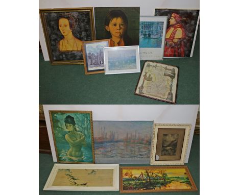
Unknown artist a portrait of Cardinal Thomas Wolsey (1471-1530) based on a work of circa 1520 20th Century print on canvas 50cm x 60cm unframed,Unknown English artist a portrait of Anne Boleyn (1501-1536) based on a work of circa 1533-1536 20th Century print on canvas 50cm x 60cm framed, J H Lynch (20th Century) an exotic beauty print 50cm x 70cm framed; D Bragolin a tearful girl print 50cm x 70cm unframed, Two framed poster prints of works by Claude Monet (1840-1926) : Venise Palazzo de Mula, 49cm x 55.5cm; La Debacle sur la Seine 82cm x 60cm; a further Monet print of Waterloo Bridge 32cm x 23cm together with a framed coloured print on card of thatched cottages beside a flooded dyke 85cm x 34cm, Tyrus Wong (20th Century) Shangri-La print on board 74cm x 29cm framed, Highland cattle in the glen print 20cm x 30cm painted frame another print and a map, (14)


Lot 158
Benromach-1971 (2)Bottled 1993. Connoisseurs Choice, bottled by Gordon & MacPhail. Map labels.Good labelling. Level: very top shoulder. 70 cl. Single malt, 40% volume2 bottlesThis lot is subject to the following lot symbols: PP This lot is owned by a private individual. The right of return enjoyed by EU customers is not applicable.For further information on this lot please visit Bonhams.com
Lot 284
Walkers Devonshire original linen map, antiquarian print of Royal Theatre, Plymouth and a print by Punch, these are being sold on behalf of The Lord Mayor of Plymouth, Mr Richard Ball, to raise money for two of his charities, Help the Heroes Recovery Centre in HMS Drake and also Friends of St Andrews Minster, Plymouth's premier Anglican Church.


Lot 104
Milne (A. A.) Winnie-the-Pooh, first edition, illustrations by E.H.Shepard, map endpapers (very slightly browned), original pictorial green cloth, gilt, a little mottled by damp, first state dust-jacket with "7/6 Net" to spine and "117th Thousand" at head of rear flap, very slightly rubbed, spine a little soiled and frayed at ends, 8vo, 1926.
Lot 119
Game.- Wallis (Edward, publisher) Wallis's New Game of Wanderers in the Wilderness, folding hand-coloured aquatint pictorial map of South America with pictorial cartouche of tiger, snakes, parrot, monkey and alligator by J.H.Banks, dissected and mounted on linen, c.680 x 515mm., lightly soiled, one or two small stains, split to linen between two sections, with the very rare booklet of rules and descriptions, original printed pink wrappers, slightly soiled and faded at edges, together in original embossed cloth slip-case, upper cover titled and with decorations in gilt, rubbed and a little faded, small stain and worn patch to upper cover, [Whitehouse p.16], small 4to, [c.1844].⁂ Charming game depicting scenes, geography, flora & fauna of South America including a jaguar, tapir, anacondas, llamas, condor, rhea, whales, collecting juice from an agave tree, washing margin diamonds in troughs, panning gold, a gaucho lassooing wild cattle, the towns of Rio de Janeiro, Buenos Aires, Valparaiso, Lima & Quito, and Alexander Selkirk (Robinson Crusoe) on the island of Juan Fernandez. It is a companion game to Wallis's Game of the Star-Spangled Banner, or Emigrants to the United States of c.1842, a copy of which was sold in these rooms in November 2019 (lot 275). Library Hub records 3 UK copies of the present game (BL, Cambridge and Oxford) but only the British Library copy is complete with the rules booklet."No.22. Hark at the horrid sounds which proceed from the forest! It is the death roar of a Jaguar which an immense Boa-Constrictor is in the act of crushing to a jelly...You cannot pass him, but must return to No.7.No.66. I see the track of CAYMEN in the mud. Ah! there is one. He plunges in the stream with an unhappy negro whom he has surprised in his tremendous jaws. Now the shrieks of his struggling victim are stifled beneath the waves".

Lot 120
Game.- Wallis (Edward, publisher) European Travellers, an Instructive Game, folding hand-coloured aquatint pictorial map of Europe, dissected and mounted on linen, c.500 x 670mm., colouring rather crude, soiled and lightly worn, some pencil scribblings and scorings (partly erased causing abrasion), creased at edges, folding into original blind-stamped green cloth, upper cover titled in gilt, lacking ties, rubbed, a few stains, spine faded, E.Wallis, [c.1845] § Wallis (J. & E., publishers) The Panorama of Europe, a New Game, hand-coloured engraved sheet with 39 engraved city views in anti-clockwise spiral around title and larger central view of London, dissected and mounted on linen, c.475 x 630mm., rather soiled and browned, one or two stains, some sections creased at corners, lacking slip-case, J. & E.Wallis and J.Wallis Junr., 1815, [Whitehouse pp.16 & 37], small 4to & tall 8vo (2)⁂ The first is a scarce race game from the Arctic Sea to London via the Urals, depicting polar bears and whales, Cossacks, sledging and troikas in Russia, camels in the Holy Land, porcelain-making in Germany, bull-fighting, wine-making and various city views.
Lot 153
Dorset.- Lyme Regis.- Roberts (George) The History of Lyme-Regis..., list of subscribers, errata leaf, 2 folding lithographed views, original boards, uncut, spine stained and defective, Sherborne, 1823; The History and Antiquities of the Borough of Lyme Regis and Charmouth, folding hand-coloured geological map (tightly bound and unable to unfold), folding lithographed plate of Ichthyosaurus fossil (a little spotted), list of subscribers but no errata at end, original embossed cloth, roan label, spine faded, 1834 § Brown (H.Rowland) The Beauties of Lyme Regis, Charmouth, the Land-slip..., presentation copy from the author (recipient's name erased), 9 engraved or wood-engraved plates (some with 2 images), one folding of the Land-slip, advertisement leaf and 32pp. illustrated catalogue at end, one plate with light water-staining, scribblings in blue crayon to final leaf of Index, original cloth, slightly damp-stained, Lyme Regis, [c.1840], first editions, a little rubbed; and 4 others, duplicates, 8vo et infra (7)
Lot 155
Lake District.- Wordsworth (William) & others. A Complete Guide to the Lakes..., edited by the publishers, 3 engraved views, 5 cross-sections, folding engraved map hand-coloured in outline, some foxing, mostly to views, original green cloth, upper cover titled in gilt, a little damp-spotted, 12mo, Kendal, Hudson & Nicholson; London..., 1842.⁂ First edition in this form of a guide to the lakes, containing descriptions of the scenery by Wordsworth and of geology by his friend Rev. Prof. Sedgwick.
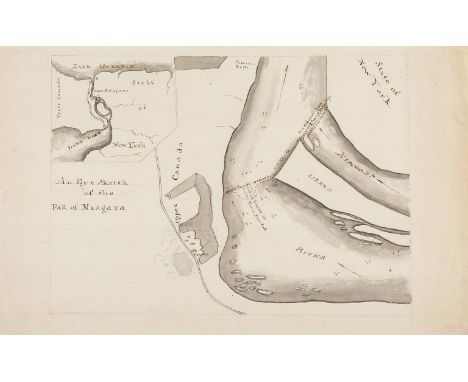
Lot 158
Canada.- Baker (Lt. Col. Sir Edward), Circle of. An Eye Sketch of the Fall of Niagara, manuscript plan centred on the Horseshoe Falls and Goat Island (unnamed), with inset map showing Lake Eerie to Lake Ontario in the upper left corner, with a single road track alongside the west of Niagara River and a Tavern located, ruled pencil border, pen and brown ink, grey wash over pencil, on laid paper with watermark of George III's coat of arms [circa 1801 or slightly earlier], sheet 304 x 188 mm. (12 x 7 3/8 in), minor handling creases, marginal faint soiling, unframed, [circa 1795 or slightly later]Provenance:James Stevens-Cox (possibly acquired from the same source as the Col. Sir Edward Baker copy of Samuel Hearne's 'A Journey from Prince of Wales's Fort in Hudson's Bay', which featured an early manuscript map in a similar hand, and was sold in these rooms [see Lot 6, 31st May 2018])⁂ Scarce example of the early mapping of Upper Canada, and of the falls "so justly celebrated as the first in the world for grandeur" [John Franklin, British explorer, 1825]. The handling of the present map, specifically the text inscriptions for 'Niagara/ River' and the other various annotations, directly compare with several parts of the manuscript map sold in these rooms (see provenance) that was bound into a copy of Hearne's 'A Journey from Prince of Wales's Fort in Hudson's Bay'; the personal copy of Lt. Col. Sir Baker.
Lot 160
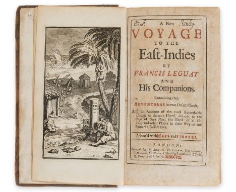
Indian Ocean.- Leguat (François) A New Voyage to the East-Indies...Containing their Adventures in two Desart Islands...Maurice Island, Batavia, at the Cape of Good Hope...St.Helena..., first English edition, engraved frontispiece, title in red and black, 32 engraved plates and maps, many folding, including large plate with letterpress verses opposite p.104, with advertisement leaf and 4pp. catalogue bound after dedication (latter not called for by ESTC) and another advertisement leaf at end, text browned but plates very clean, large map torn and repaired, old ink signature of Edward Stanley, Earl of Derby at head of title and with his bookplate, contemporary panelled calf, rubbed, rebacked with red morocco label, [Mendelssohn pp.875-77], 8vo, R.Bonwicke, W.Freeman [etc.], 1708.⁂ Possibly an imaginary voyage and a compilation of previous writings, the book recounts the voyage of a party of Huguenots under Leguat, sent by the Dutch government to the Ile de Bourbon (Réunion), but on finding the island occupied by the French, the party sailed on to Rodriguez Island, where they stayed for two years before proceeding to Mauritius. The plates mostly feature flora and fauna including flying fish, a pineapple, rhinoceroses, "extraordinary plants", and a Rodriguez Solitaire, a close relation to the Dodo, which was extinct by 1746.

Lot 162
North America.- Domenech (Abbé Emmanuel) Seven Years' Residence in the Great Deserts of North America, 2 vol., folding hand-coloured engraved map, 58 wood-engraved plates, many tinted or colour, lacking half-titles and final advertisements, contemporary green calf, spines gilt, 1860 § Murray (Hon. Charles Augustus) Travels in North America, 2 vol., half-title in vol.2 only as called for, 2 lithographed frontispieces, vol.1 with ink signature to head of title, contemporary tan calf, spines gilt, 1839, first editions, both a little rubbed with a few scuffs or marks to boards, [Sabin 20554 & 51490], 8vo (4)
Lot 188
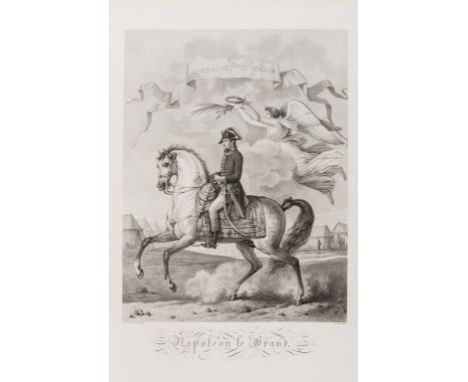
Napoleon.- Vernet (Carle) Tableaux historiques des campagnes d'Italie, depuis l'an IV jusqu'à la bataille de Marengo, suivis du Précis des opérations de l'Armée d'Orient, des détails sur les cérémonies du Sacre, des bulletins officiels de la Grande Armée et de l'Armée d'Italie dans tout le cours de la dernière guerre d'Allemagne, jusqu'à la paix de Presbourg, half-title, fine engraved portrait of Napoleon on horseback by Simon after Vernet, 24 plates by Duplessi-Bertaux and others after Vernet only, double-page map, hand-coloured in outline, by Louvet after Dieu, divisional title to 'Cérémonies du Sacre' with stipple-engraved portraits of Napoleon and Josephine, engraved head- and tail-pieces, lacking text pp. 15-16 (1 f.) and 133-136 (2 ff.), c.5 plates with a small stain, occasional spotting and light browning, light green half ?morocco over dark green contemporary marbled boards by Bell Golding, Cambridge, gilt spine in compartments and with original red morocco label, folio, Paris, Auber, 1806. ⁂ A handsomely produced piece of Napoleonic propaganda, recording his achievements in Italy, Egypt and Germany, along with details of his coronation in 1804.

Lot 213A
18th century Navigation.- Navigation, manuscript, 174pp., partially ruled in red, 2 folding pen and ink maps hand-coloured in outline, numerous pen and ink diagrams, slightly browned, new endpapers, modern cloth, some edges slightly chipped, folio, dated in text and map at end 1791.⁂ A manual for teaching navigation. Headings include: "A Journal of a Voyage... In the Henry of Whitby... A.B. Commander... Kept by J. Breckon... November 17th 1791"; "Mercator's Sailing. The Construction & Use of the Meridional Parts"; "To work an Observation, or to find the Latitude of a Place by the Tables of the Sun, or Stars..."; "To find the Time of High Water"; "Construction of Mercator's Chart"; "Parallel Sailing" etc. Maps comprise: "A Mercator's Chart... Drawn by Joseph Wilson 1791"; "A Plane Chart" [showing the UK and Europe and its seas].
Lot 244
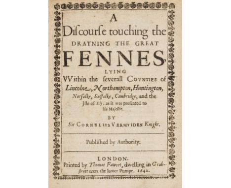
Vermuyden (Sir Cornelius) A Discourse touching the Drayning the Great Fennes, first edition, with the rare leaf A1 with large woodcut of Royal arms, title with typographic border, lacking the map, woodcut initials, later marbled wrappers, [Wing V241], 4to, Printed by Thomas Fawcet, 1642.⁂ Vermuyden (1595-1677), a Dutch engineer, wrote this discourse for Charles I in 1637, although it was not published until 1642, and made two proposals: washes (areas of land permitted to flood in times of very wet weather) and a catchdrain at the eastern edge of the fen. The washes were constructed in the 1650s but the catchdrain not until the 1960s. Having been appointed as agent by Charles I in 1639 the Civil War interrupted the works and did not proceed again until 1649, being completed in 1652.ESTC lists 7 UK locations, but the collation given (?BL) is lacking the first leaf. Only 3 copies have appeared at auction including, most recently, the Rothamsted copy with map, which sold in these rooms in July 2018 for £11,000.
Lot 278
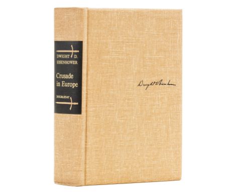
Militaria.- Eisenhower (Dwight D.) Crusade in Europe, number 1,269 of 1,400 copies with a facsimile of the D-Day order signed below by the author, signed presentation inscription from the author to Field Marshall Viscount Slim "Whose brilliant military leadership in World War II won the admiration and acclaim of the allied world. With best wishes and regards from his comrade-in-arms" on half-title, bookplate of Viscount Slim to endpaper, map endpapers, original cloth, very light fading to spine, but a fine copy overall, t.e.g., others uncut, plastic jacket, 8vo, New York, 1948.⁂ An unusually fine copy with a superb inscription from the author to one of the great military leaders of the Second World War. Field Marshall Viscount Slim (1891-1970) led the so-called "Forgotten Army" in the Burma campaign against the Japanese. His transformation of the Allied Burma Corps and the subsequent successes achieved earned him the reputation as one of the best generals of the war.
Lot 280
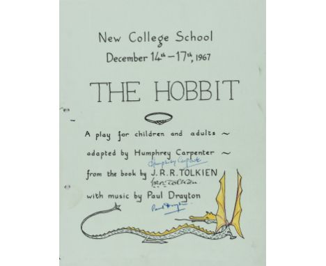
Tolkien (J. R. R.).- Printed programme for the New College School, Oxford, production of The Hobbit, adapted by Humphrey Carpenter with music by Paul Drayton, 4pp., illustrations, with map by Drayton to final p., signed by Tolkien, Carpenter and Drayon on upper cover, additionally signed by 9 members of the case, hole punch rings to margins, the dragon coloured by hand, [Hammond pp.23-24], 1967 § Carpenter (Humphrey) "The Hobbit". A Play for Children and Adults, typescript, several markings and underlinings along with a few drawings relating to the production in a young hand, original programme loosely inserted, the sheets hole-punched at inner margins with ring fasteners in contemporary limp boards with related drawings to upper cover, extremities a little worn, 1967; with a contemporary vinyl recording of the play, 4to (3)⁂ A rare signed playbill for the second theatrical adaptation of The Hobbit.The first production of The Hobbit was performed at St. Margaret's School, Edinburgh for teachers and parents in 1953. This second production was a larger affair, performed over three nights, with the author in attendance on the final night. The play was adapted by Humphrey Carpenter and music composed by the school music teacher Paul Drayton (who also drew the map for the lower cover). Signed copies of the book were raffled off each night, Tolkien also signed copies of the programme for the performers.
Lot 328
Gardens.- Laborde (Alexandre de) Description des Nouveaux Jardins de la France et de ses Anciens Chateaux, 2 vol., first edition, text in French, English and German, half-title to text vol., plate vol. with fine engraved title with large vignette, a map, 2 plans, and 122 plates after Constant Bourgeois on 89 sheets, plus 3 additional sheets (2 of which with 4 plates with overslips and 1 plate of images to be cut out for overslips), tear to lower margin of plate 104, spotting, occasional foxing (mostly marginal), occasional light browning, contemporary half calf over light yellow boards, spines richly gilt and with red and black morocco labels, spine ends neatly repaired, boards with some scuffing, rubbed, [Millard, French Books, 84], folio (465 x 329mm.; binding 476 x 344mm.), Paris, Delance, 1808.⁂ A very good set of what Millard calls 'an invaluable record of each of the gardens illustrated, and of a type of garden design that has all but disappeared.'
Lot 359
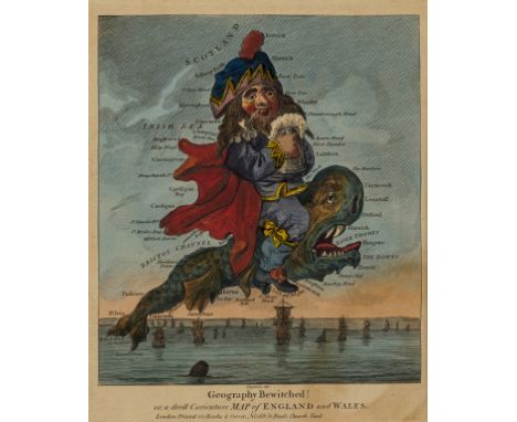
Dighton the Elder (Robert, 1752-1814) Original design for 'Geography Bewitched! or, a droll Caricature Map of Scotland', point of the brush, ink and watercolour, signed lower left, partly trimmed, and with title inscribed in the lower quadrant, sheet 185 x 160 mm. (7 1/4 x 6 1/4 in), under glass, tipped onto mount support, some spotting and surface dirt, [circa 1796]; together with three very good impressions of the related series of caricature maps of the British Isles, Geography Bewitched! or, a droll Caricature Map of England and Wales; Geography Bewitched! or, a droll Caricature Map of Scotland; Geography Bewitched! or, a droll Caricature Map of Ireland, engravings with hand-colouring, each approx. 215 x 180 mm. (8 1/2 x 7 1/8 in), all under glass, printers' creases to Scotland, otherwise all with some light toning and surface dirt and, presented in two uniform frames, published by Bowles & Carver, [circa 1796] (4)Provenance:Ex-collection of David PadburyLiterature:BM Satires 8397, 8398 and 8399[Original watercolour] Padbury, The Dighton family, their times, caricatures and portraits, 2007, illus. p. 29
Lot 377
Africa.- Lyon (Capt. George Francis) A Narrative of Travels in Northern Africa, first edition, large folding engraved map hand-coloured in outline and 17 hand-coloured lithographed plates by M. Gauci, after drawings by the author, tissue-guards, attractive modern antique-style brown half morocco, spine gilt with red morocco label, [Abbey, Travel 304; Blackmer 1044], 4to, 1821.⁂ Accompanied by Joseph Ritchie, Lyon left Tripoli to discover the source of the Niger river. They travelled disguised as Muslims but at Murzuq, the capital of Fezzan, Ritchie fell ill and died.
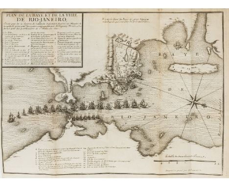
Lot 38
Naval.- Duguay-Trouin (René) Memoires de Monsieur Du Guay-Trouin, Lieutenant General des Armées Navales de France, first Amsterdam edition, engraved portrait, title in red and black with engraved vignette, 5 folding engraved plates by J.P. Le Bas and folding map of the bay of Rio de Janeiro, frontispiece a little water-stained, lightly foxed at beginning and end, contemporary sprinkled calf, rubbed, rebacked, corners repaired, new endpapers, Amsterdam, Pierre Mortier, 1740.⁂ Account of the exploits of the famous French buccaneer during the War of the Spanish Succession; his most notable feat was the capture of Rio de Janeiro.
Lot 381
America.- Carver (Jonathan) Travels through the interior parts of North-America, in the years 1766, 1767, and 1768, first edition, 2 folding engraved maps, 4 engraved plates, short tear without loss to the map of Carver's travels, offsetting, occasional spotting, contemporary mottled calf, rebacked, preserving original backstrip in compartments with modern red morocco label and gilt, corners little worn, rubbed, [Sabin 11184; Howes C215], 8vo, printed for the author; and sold by J. Walter, at Charing-Cross, and S. Crowder, in Pater-Noster Row, 1778.⁂ Carver 'penetrated farther into the West than any other English explorer before the Revolution.' (Howes). Includes the first instance in print of the word 'Oregon', a guide to flora and fauna, and a vocabulary of the Chippewa language.
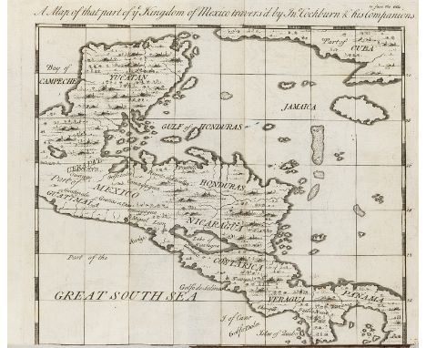
Lot 382
Americas.- Cockburn (John) Journey over Land, from the Gulf of Honduras to the Great South-Sea, first edition, folding engraved map, woodcut initials and head- & tail-pieces, 3pp. advertisements at end, occasional light marginal soiling, but generally clean internally, contemporary calf, gilt, joints neatly repaired, an excellent copy, [Hill 324; Sabin 14095], 8vo, C.Rivington, 1735.⁂ Having been captured by pirates off the coast of Honduras Cockburn and five others escaped and made their way across the isthmus to the Pacific coast, enduring such hardship along the way that this account was for many years regarded as mostly fiction.
Lot 384
Americas.- Herrera y Tordesillas (Antonio ) Novus orbis, sive descriptio Indiae occidentalis, 4 parts in 1 vol., engraved additional title, 17 folding engraved maps, 5 engraved illustrations, lacking final blank f., light browning, occasional light dampstaining to lower margin, letterpress title slightly soiled and with small chips to corners, 19th century morocco-backed boards, extremities rubbed, [Sabin 31540], folio, Amsterdam, Colijn, 1622.⁂ The first complete account of the Le Maire-Schouten expedition around the world, the first to successfully round Cape Horn, and the first edition in Latin, expanding significantly the Madrid edition of 1601. The engraved map on the title is the first depicting California as an island. Provenance: Henry N. Stephens (inscription on endpaper dated 21 August 1884, recording the price £1.10); A.H. Bright (armorial bookplate).
Lot 385
America.- Kalm (Peter) Travels into North America; containing its natural history, and a circumstantial account of its plantations and agriculture in general, With The Civil, Ecclesiastical And Commercial State Of The Country, The Manners of the Inhabitants, and several curious and Important Remarks on various Subjects, 3 vol., first edition in English, first issue (Warrington imprint to vol.1), list of subscribers to vol.2, large engraved folding map, 6 engraved plates, advertisement f. to end of vol.1 regarding the sheet map of North America and subscriptions for the second volume, offsetting, a few small stains, occasional spotting, contemporary tree calf, spine gilt and with red and smaller black morocco labels, vol.2 lower corners worn, rubbed, [Howes K5; Sabin 36989; Streeter Sale 823], 8vo, Warrington, William Eyres and London, printed for the editor; and sold by T. Lowndes, 1770-1771. ⁂ A very good set of this work, which Streeter calls 'One of the most important and reliable eighteenth-century accounts of American natural history, social organization and political situation', and Howes considers a 'most trustworthy description of Swedish settlements in 18th century Delaware, New Jersey and Pennsylvania.',Provenance: 'Charlotte B. Hutchinson 1799' and George Hutchinson (ink inscriptions to endpapers or titles).
-
109182 item(s)/page