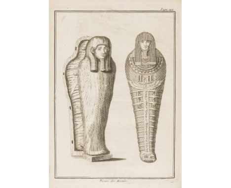

Egypt.- Maillet (Benoît de) Description de l'Egypte, contenant plusieurs remarques curieuses sur la geographie ancienne et moderne de ce pais, sur ses monuments anciens, sur les moeurs, les coutumes, & la religion des habitans, sur le gouvernement & le commerce, sur les animaux, les arbres, les plantes, &c., edited by Jean-Baptiste Le Mascrier, first edition, engraved portrait frontispiece, title in red and black and with woodcut ornament, engraved folding map, 7 plates, of which 2 folding, head- and tail-pieces and decorative initials, short tape repair to foot of map, some spotting throughout, occasional foxing, 19th century blind-stamped and gilt calf, spine in compartments and with black morocco label, spine faded, g.e., [Atabey 754; Blackmer 1061], 4to, Paris, Louis Genneau & Jacques Rollin, 1735. ⁂ Scarce. Maillet was French consul to Egypt and a writer on geological and evolutionary matters.
We found 109182 price guide item(s) matching your search
There are 109182 lots that match your search criteria. Subscribe now to get instant access to the full price guide service.
Click here to subscribe- List
- Grid
-
109182 item(s)/page

Europe.- Lapie (Pierre) Carte de la Russie d'Europe, avec l'Empire d'Autriche, la Suede, le Danemark et la Norvege, la Prusse, le Grand Duche de Varsovie, les provinces Illyriennes, et une partie de la Confederation du Rhin et de la Turquie d'Europe, engraved map, hand-coloured in outline, on 6 sheets, each c.910 x 618mm., some offsetting, the odd spot, bound into contemporary half calf, upper cover with red morocco gilt title label, spine ends and corners little worn, rubbed, folio (binding 632 x 484mm.), Paris, François Tardieu, 1812.
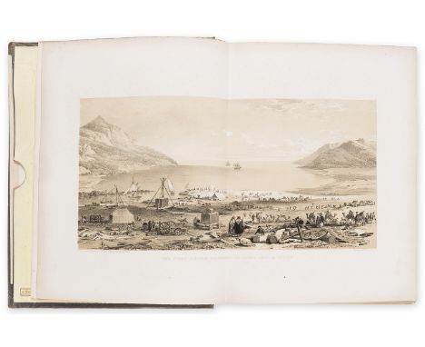
Levant.- Chesney (Francis Rawdon) The Expedition for the Survey of the Rivers Euphrates and Tigris... in the years 1835, 1836, and 1837, 2 vol., first edition, large paper copy, 49 lithographed plates, folding map in pocket at front of vol. 1 but lacking 13 additional slip-cased maps (as often), occasional spotting, mostly to plate margins, original cloth, spines faded, neat repairs to extremities, [Atabey I, 234; Blackmer 337], 4to, 1850.⁂ Chesney, the founder of the overland route to India, intended the work to be complete in four volumes, but half the manuscript was lost and only these two volumes were published.
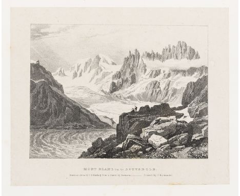
Mountaineering.- Auldjo (John) Narrative of an Ascent to the Summit of Mont Blanc on the 8th and 9th August, 1827, first edition, large paper copy, half-title, 22 lithographed plates, plans, maps, cross-sections etc. including 7 views on india paper and mounted, one folding panorama, facsimile letter, map with routes hand-coloured and hand-coloured geological table & chart of heights of mountains, some light foxing, mostly marginal, pencil quotation on half-title, short tear to upper edge of H2, original boards, uncut, paper label on spine, spine and joints neatly repaired, preserved in modern card chemise and cloth slip-case, [Meckly 8; Neate A75; Perret 183], 4to, 1828.
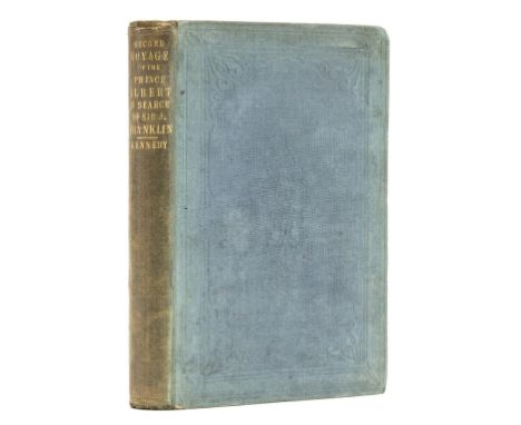
Polar.- Kennedy (William) A Short Narrative of the Second Voyage of the Prince Albert, in search of Sir John Franklin, first edition, folding engraved map, 4 lithograph plates, list of subscribers to the Branch Expedition at end, Hydrographic Office ink stamp at foot of title, original cloth, soiled and partially faded, [Arctic Bib. 8539; Sabin 37443], 8vo, 1853.⁂ Rare at auction. William Kennedy (1814-1890) was the son of a Hudson's Bay Company factor and a Cree Indian. In 1851 he was chosen by Lady Franklin to lead the second private expedition in search of her husband. Although he found no trace of Sir John, the expedition discovered Bellot Strait in the far north of America. Kennedy was also the first to use dogs and sleds from an exploring ship.
![Polar.- Parry (Capt. William Edward) [A complete set of Parry's four voyages], 4 vol., first editions, comprising Journal of](https://cdn.globalauctionplatform.com/69e3a445-7f2f-4eb7-bed7-abbb011419ca/ddbfaac7-289f-4775-b70c-abbb011d346c/468x382.jpg)
Polar.- Parry (Capt. William Edward) [A complete set of Parry's four voyages], 4 vol., first editions, comprising Journal of a Voyage for the Discovery of a North-West Passage, from the Atlantic to the Pacific...in the years 1819-20, in His Majesty's Ships Hecla and Griper, second edition, 15 engraved plates, most aquatint, and 5 engraved maps, 4 folding or double-page, 1821; Journal of a Second Voyage...in the years 1821-22-23, in His Majesty's Ships Fury and Hecla, first edition, 31 engraved plates and plans, some aquatint, and 9 large folding engraved maps and panoramas, 1824; Journal of a Third Voyage...in the years 1824-25, in His Majesty's Ships Hecla and Fury, first edition, 10 engraved plates and plans, one folding, and large folding engraved map, 1826; Narrative of an attempt to reach the North Pole...in the year MDCCCXXVII, first edition, 6 engraved plates and plans and large folding engraved map, 1828, occasional light foxing and offsetting, Northern Light Board ink stamps to verso of titles and gilt stamps of same to head of spines, uniform 19th century calf, spines gilt, covers a little rubbed, an attractive set, [Sabin 58860; 58864; 58867 & 58868], 4to.⁂ A complete set of Parry's three voyages in search of the North-West Passage together with his fourth voyage to the North Pole. The second voyage contains important information on Eskimo life, and the third voyage collected additional scientific information about the Arctic region of North America. On the fourth voyage Parry unsuccessfully tried using reindeer rather than dogs to pull his sledge-boats, but they proved too heavy to manoeuvre across the ice.

Ireland.- Ortelius (Abraham) Eryn - Hiberniae, Britannicae Insulae, Nova Descriptio - Irlandt, map of Ireland, with north oriented to the right, strap-work title and scale cartouches, with a ship off the northern coastline, engraving on laid paper with indistinct watermark, fine early hand-colouring heightened with gold, platemark 355 x 485 mm. (14 x 19 in), sheet 395 x 545 mm. (15 1/2 x 21 1/2 in), French text verso, central vertical fold with repaired splitting and reinforced verso, several marginal repaired tears and careful repairs to worm holes found within map, exposure lines, toning and surface dirt, unframed [Antwerp, 1584 or slightly later].Literature:VdB 22⁂ Based on Mercator's 1564 wall map of the British Isles, it is the first map of Ireland to include any geographic details.
![Yorkshire.- Barnsley plans.- Kendray (F[rancis?]) 15 original pen and ink plans of Barnsley and vicinity on paper, most with](https://cdn.globalauctionplatform.com/69e3a445-7f2f-4eb7-bed7-abbb011419ca/300d50a9-12e6-4b4c-8542-abbb01221b0a/468x382.jpg)
Yorkshire.- Barnsley plans.- Kendray (F[rancis?]) 15 original pen and ink plans of Barnsley and vicinity on paper, most with partial wash or outline hand-colouring, the first with small cartouche of two winged figures holding the title banner, two with A Scale of Chains, a couple with later pencil annotations, the last 2 spotted, contemporary half calf with gilt-lettered red morocco title label to upper cover, rebacked, rubbed, folio, Barnsley, 1800.⁂ A rare record of the South Yorkshire town at the turn of the 18th/19th century executed by a member of an important local family, after whom an area and hospital are named. There are several later Francis Kendrays recorded, but we have been unable to verify for certain that this work is by an earlier Kendray of that name, though this seems likely. Each map measures 370 x 225mm.
![[Godwin (William)], "Theophilus Marcliffe". The Looking-Glass. A True History of the Early Years of an Artist..., first editi](https://cdn.globalauctionplatform.com/69e3a445-7f2f-4eb7-bed7-abbb011419ca/730c8fc7-159d-4543-b2a9-abbb0121adfb/468x382.jpg)
[Godwin (William)], "Theophilus Marcliffe". The Looking-Glass. A True History of the Early Years of an Artist..., first edition, stipple-engraved frontispiece, 3 engraved plates only (of 4), 6pp. publisher's catalogue at end, foxed and soiled, old manuscript notes and cuttings on or tipped to front endpapers, original printed boards, rubbed and stained, manuscript label to spine, Thomas Hodgkins, 1805 § [Jenner (Isaac)] Fortune's Football, stipple-engraved frontispiece and plate, light foxing, contemporary ink inscription to front endpaper, contemporary roan-backed boards, spine worn and defective, upper cover detached, for the Author, Tabart & Co., 1806 § [Longueville (Peter)] The English Hermit; or, the Adventures of Philip Quarll..., wood-engraved frontispiece, map and illustrations, a few hand-coloured, 8pp. catalogue at end, spotting, contemporary half red roan, Baldwin, Cradock, and Joy..., 1816, rubbed; and 7 others, children's, including defective copies of Little Fanny and Little Henry, 12mo (10)⁂ The subject of the first is the artist William Mulready who illustrated The Butterfly's Ball.


Christopher and John Greenwood (19th Century) - Coloured engraving - "Map of the County of Kent, Actual Survey made in Year 1819 and 1820", 23ins x 27.5ins, and eight 19th Century coloured engravings of Kent interest, various sizes, including - Charles Joseph Hullmandel (1789-1850) - "Part of Rochester Cathedral and Castle", published by Rodwell & Martin, New Bond Street, 1822, 8.75ins x 10.75ins, all framed and glazed

W. G. Fearnside (ed) - "Tombleson's Views of the Rhine", illustrated with numerous Views of Towns, Cities and of the river Rhine, with folding map to front, published by W. Tombleson & Company, 11 Paternoster Row, London, 1832, one volume with green leather spine, Sir Vivian Fuchs & Sir Edmund Hillary - "The Crossing of Antarctica", published by Cassell & Company Limited, 1st edition 1958, one volume, and four other books of topographical and art interest


Thomas Bowen (d.1790), an engraved and coloured Ogilby-type strip map, A Map of the Roads from London to Barnard - Castle, Derby, Nottingham &c, The Road to Barnard - Castle in the Bishoprick (sic) of Durham commences at Ferrybridge in the York Road, taken from The Gentleman's Magazine: and Historical Chronicle' by Sylvanus Urban, 1774, 18.5cm x 28cm, framed

![Captain Greenville Collins, a coloured two-page map, Fowey & Mounts Bay [Cornwall] is Most Humbly Dedicated to the Right](https://cdn.globalauctionplatform.com/cd1b5f19-01ad-40e6-9a91-abbc009040ce/013eab28-8b3b-444d-b946-abbc011b0a2e/468x382.jpg)


Fuller (Thomas) The Historie of the Holy Warre, additional engraved title, folding engraved map, 'declaration of frontispiece' pasted to preliminary blank verso, [Wing F2438], 1647, bound before The Holy State, additional engraved title, illustrations, marginal worming, staining, short marginal tear (T1), small marginal hole (2M4), [Wing F2444], Cambridge, 1648, occasional spotting, near contemporary calf, rebacked, slightly bumping to corners, together 2 vol. bound as 1, folio

Shenstone (William) The Works in Verse and Prose, 3 vol., first edition, vol.1 and 2 with engraved title-vignette, frontispieces, folding map and 3 vignette head-pieces, occasional foxing and browning, contemporary calf, spines gilt in compartments with red and green morocco labels, vol. 1 joints cracking at head, some light rubbing to extremities but a handsome set overall, 8vo, 1764-69.
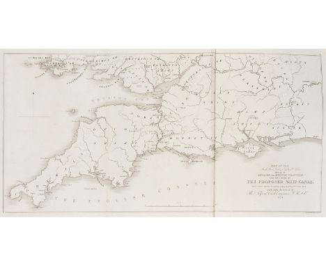
Canals.- Telford (Thomas) Ship Canal, for the Junction of the English and Bristol Channels, first edition, engraved folding map with proposed route of canal and 2 folding plans, some creasing, contemporary dark green straight-grain morocco, gilt, rubbed, folio, Printed for S. Brooke, 1824. ⁂ An ambitious plan to link the Bristol and English channels thereby dispensing of longer journeys around the coast. A bill was passed allowing the building of what was to be called the 'English and Bristol Channels Ship Canal', which would run from Stolford on the Bristol side to Beer, near Seaton on the other. It was to be 44 miles long with 60 locks and be able to carry ships up to 200 tonnes. Sadly, the company were unable to raise funds for the project.
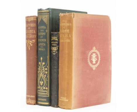
Africa.- Hamilton (James) Wanderings in North Africa, first edition, half-title, engraved plates, bookplates, original cloth, spine faded, light fraying to head of spine, 1856 § Hofland (Mrs.) Africa Described, new edition, engraved folding map, publishers blind-stamped morocco, spine ends a little chipped, 1834 § Walmsley (Hugh Mulleneux) Sketches of Algeria During the Kabyle War, original cloth, light rubbing to extremities, near-fine otherwise, 1858; and another, Africa, 8vo (4)

Africa.- Ortelius (Abraham) Africae Tabula Nova, map of the African continent, with Madagascar and part of the Arabian Gulf, Zanzibar is shown on the west coast, decorated with a large strapwork title cartouche, a grand sea battle, fantastic sea creatures, and in the Indian Ocean the ghost-like sea monster is off the coast of Arabia, engraving with fine early hand-colouring, on laid paper with watermark of small armorial device with indistinct text below, platemark 376 x 505 mm. (14 3/4 x 19 7/8 in), sheet 400 x 557 mm. (15 3/4 x 21 7/8 in), German text verso, some contemporary ink marginalia, central vertical fold with parallel crease and small splits, small area of loss to lower left corner but not affecting map, minor surface dirt, unframed, [1570 or later].Literature:VdB 8⁂ A cornerstone map for African collections. Designed by Ortelius from elements of contemporary maps by Gastaldi, Mercator, and Forlani.
Africa.- South Africa.- Latrobe (Rev. Christian Ignatius) Journal of a Visit to South Africa in 1815, and 1816, first edition, folding engraved map with routes supplied by hand in red and blue, 12 hand-coloured aquatint plates, 4 engraved outline panoramas, offsetting, some spotting or foxing, short tear without loss to final index f., contemporary dark blue half morocco, gilt, spine in compartments, 1 lower corner bumped, rubbed, [Abbey, Travel 325; Mendelssohn pp.886-87], 4to, 1818.

NO RESERVE Africa.- Western Africa.- Elwe (Jan Barend) Carte de la Barbarie le la Nigritie et de la Guinee..., map of northern and Western Africa, showing from the Kingdom of Tripoli and the Mediterranean to the Gulf of Guinea and the Gabon River, includes the Canary Islands, Madeira and the Cape Verdes, engraving with hand-colouring, on laid paper with indistinct watermark, platemark 490 x 575 mm. (19 1/4 x 22 3/4 in), sheet 540 x 640 mm. (21 1/4 x 25 1/4 in), central vertical fold, minor surface dirt and one or two small rust spots, unframed, 1792.

America.- Burton (Sir Richard Francis) The City of the Saints and Across the Rocky Mountains to California, second edition, half-title, wood-engraved frontispiece, 7 plates, folding map and plan and illustrations, half-title and final f. browned, occasional spotting, original green cloth, spine and upper part of lower cover faded, [Penzer pp.68-69], 8vo, 1862.

America.- Frothingham (Richard) History of the Seige of Boston, second edition, 3 engraved folding map, 1 torn, bookplates, original cloth, spine ends and corners chipped, 1851 § Oliphant (Laurence) Minnesota and the Far West, lithographed frontispiece, plates and illustrations, spotting, bookplate, ink inscription to pastedown, original pictorial cloth, surface soiling, 1855; and another on Canada, 8vo (3)
America.- Volney (Constantin-François, Comte de) Tableau du climat et du sol des Etats-Unis d'Amérique, 2 vol., first edition, half-titles, 2 folding engraved maps (1 large) and 2 folding engraved plates, errata f., a few ink spots to head of large map, occasional spotting, contemporary tree calf, gilt, spine richly so and with red and black morocco labels, rubbed, [Sabin 100692], 8vo, Paris, Courcier & Dentu, 1803.⁂ Includes a vocabulary of the Miami language.

Central Asia.- Santini (Paolo) Carte de la Georgie et Des Pays Situes Entre La Mer Noire et La Mer Caspienne..., map of Georgia, Armenia, Turkey, Azerbaijan, engraving with original hand-colouring, sheet 510 x 720 mm (20 x 28 1/4 in), several small repaired tears to the left margin, repairs visible verso but outside of map, handing creases, minor surface dirt, unframed, 1775; together with a good group of 9 other maps of the region, including a German text edition of Mercator's Persici Vel Sophorum regni Typus, the Ptolemy/Mercator map Tab. III. Asiae, in qua Colchis, Iberia, Albania, ac Armenia Maior..., two maps of Paradise by P. Starkman, and the others by Laurie & Whittle, Bonne, Buache, Delamarche, and another, engravings, some with hand-colouring, various sizes, unframed, 17th century and later (10)
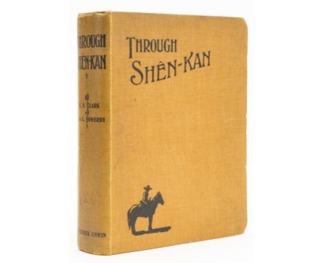
China.- Clark (Robert Sterling) & Arthur de C. Sowerby. Through Shên-Kan: the Account of the Clark Expedition in North China, 1908-9, edited by Major C.H.Chepmell, first edition, plates, some colour and mounted, folding colour map in pocket at end, original pictorial cloth, uncut, occasional light spotting, a little rubbed and soiled, corners bumped, 4to, 1912.
Europe.- Spenser (Edmund) Sketches of Germany and the Germans, 2 vol., first edition, hand-coloured frontispieces, folding engraved map, some foxing, bookplates, original cloth, spines faded, spine ends and corners a little bumped, 1836 § Kampen (Professor Van) Holland and Belgium, engraved additional title and plates, tissue-guards, hinges weak, original cloth, some fraying to spine ends and corners, [c.1860] § Eyries (Gustave) Les Chateaux Historiques De La France, vol. 1 & 2 only (of 3), titles in red and black, 28 engraved plates, spotting, bookplates, contemporary half morocco, gilt, Paris, 1877; and 6 others, European travel, 8vo & 4to (11)

NO RESERVE India.- Hughes (W.) India (North and South Sheets), 1036 x 692mm., chromolithographed, linen-backed and dissected, folding into original red cloth, lacking backstrip, upper cover detached, some fading and fraying, rubbed, George Philip and Son, [c.1860]; and a Military Traffic Map of India for 1904 (2)

Middle East.- Ortelius (Abraham) Persici sive Sophorum Regni Typus, Persia from the Caspian Sea to the Red Sea, strapwork title cartouche lower right, engraved map with original hand-colouring, a good impression on laid paper with watermark of crossed arrows [see Briquet 6283], platemark 350 x 495 mm. (13 3/4 x 19 1/2 in). sheet 410 x 550 mm. (16 1/4 x 21 3/4 in), Latin text verso with page number 64, central vertical fold, minor handling creases, spotting and browning, unframed, [circa 1571 or slightly later].Literature:VdB 167

Middle East and Eastern Mediterranean.- Jansson (Jan) Turcicum Imperium, map of the Ottoman Empire showing Cyprus and the Arabian Peninsula, engraving with outline hand-colouring, platemark 414 x 522 mm. (16 1/4 x 20 1/2 in), sheet 480 x 570 mm. (18 7/8 x 22 1/2 in), German text verso, central vertical fold with some splitting to upper and lower sections, minor spotting and surface dirt, unframed, [circa 1640].

NO RESERVE Russia.- Bobrinskii (Count Alexei) Kurgani i Sluchainiya Arkheologicheskiya Nakhodki bliz Mestechka Smeli [Burial mounds and fortuitous archaeological discoveries near Smiela], 2 vol. only (of 3), text in Russian, 4 folding maps and 55 plates, mostly lithographed, 10 chromolithographed and heightened with gold and/or silver, 2 folding, contemporary library half roan, original printed wrappers bound in, rubbed and scuffed, St. Petersburg, V.S. Balashev, 1887-94 § Tooke (William) View of the Russian Empire, 3 vol., second edition, folding engraved map, spotting, later half roan, 1800; and 3 others on Russian art, some with chromolithographs, 4to & 8vo (8) ⁂ Bobrinskii was head of the Imperial Archaeological Commission from 1886 to 1917 and his collection is now part of the Hermitage.
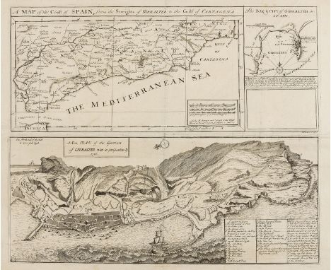
Spain.- Overton (Henry & Hoole, J., publisher ) A Map of the Coast of Spain, from the Streights of Gibralter to the Gulf of Cartagena [on sheet with] A New Plan of the Garrison of Gibralter, with its Fortifications &c., first state, three maps and plans on one sheet, without the fourth inset map of Minorca but with 'The Bay and City of Gibralter in Spain' in the upper right corner, engraving on laid paper with watermark of fleur-de-lis, platemark, 405 x 470 mm. (15 7/8 x 18 1/2 in), sheet 470 x 590 mm. (18 1/2 x 23 1/4 in), central and vertical folds with small splits, faint handling creases with small nicks and tears to edges, a few small repairs, unframed, 1727.
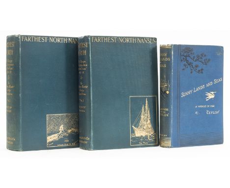
World.- Wilkinson (Hugh) Sunny Lands and Seas, first edition folding map, plates, original pictorial cloth, spine ends and corners a little bumped, 1883 § Nansen (Fridtjof) "Farthest North" Being the Record of a Voyage of Exploration of the Ship Fram 1893-96 ..., 2 vol., first English edition, half-titles, frontispieces, plates and illustrations, 4 folding colour maps, occasional spotting, original cloth, slight bumping to corners and extremities, 1897, 8vo (3)

British Isles.- Smith & Son (Charles) A Geological Railway & Canal Map of England, Wales and part of Scotland, inset map of 'Canals and Railways around Birmingham' in the lower right corner, alongside a table list of the principal canal, and colour reference list to minerals in the upper right, engraving with original hand-colouring, 990 x 810 mm (39 x 31 3/4 in), dissected and mounted on linen, some browning and surface dirt, with minor damp-staining and spotting, folding into contemporary cloth boards, rubbed and worn, spine and corners with repairs, 8vo, 1843.⁂ Scarce.
Suffolk.- Gage (John) The History and Antiquities of Suffolk. Thingoe Hundred, first edition, hand-coloured engraved map, 35 engraved plates, plans and portraits, a few mezzotint, light offsetting to title from map, occasional spotting, contemporary half green morocco, spine gilt, 1838 § Page (Augustus) A Supplement to the Suffolk Traveller, list of subscribers, a few pencil markings, contemporary half calf, label detached but loosely inserted, Ipswich and London, 1844, a little rubbed, 4to & 8vo (2)

AFTER ROBERT MORDEN "Map of Gloucestershire" hand coloured engraving together with AFTER J SKELTON "A map of Oxfordshire" to accompany Skelton's engraved illustrations of the Antiquities in the County, black and white engraved map, hand coloured, published 1827 Map of Gloucestershire size approx. 42cm high x 36cm wide excluding frame

-
109182 item(s)/page