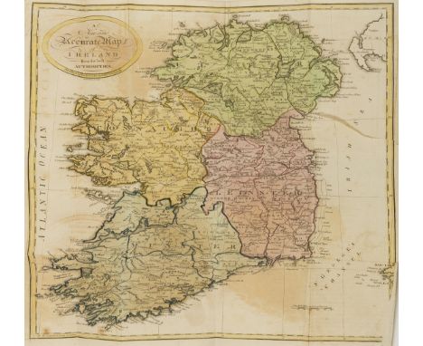
Ireland.- Robertson (Rev. Joseph) The Traveller's Guide Through Ireland, folding engraved hand-coloured map, small tear and light off-setting, occasional spotting and marginal pencil markings, cracked joints, bookplate of Rev. Daniel Augustus Beaufort, contemporary half calf, rubbed, 12mo, Edinburgh, 1806.⁂ Beaufort was an Anglican Priest, a geographer and an amateur architect, who played a vital role in the foundation of Sunday Schools and helped found the Royal Irish Academy. He was rector of Navan, County Meath from 1765 to 1818.
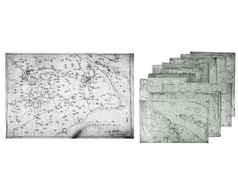
We found 108737 price guide item(s) matching your search
There are 108737 lots that match your search criteria. Subscribe now to get instant access to the full price guide service.
Click here to subscribe- List
- Grid
-
108737 item(s)/page
Ireland.- [Wilson (William)] The Post Chaise Companion or Travellers Directory through Ireland, fourth edition, engraved frontispiece, title, large folding map of Ireland, folding plan of the lakes of Killarney, and 3 plates (2 folding), offsetting, spotting, light browning, contemporary half calf, rebacked, preserving original gilt backstrip (with loss at ends), corners worn, rubbed, a scarce edition, 8vo, Dublin, J. Fleming, [c.1814].
London.- Wyld (James) Wyld's New Plan of London and its Vicinity, showing from Highgate down to Brixton, and Victoria Docks across to Wormwood Scrubs, lithographed map with hand-colouring, 800 x 1140 mm. (31 1/2 x 44 3/4 in), dissected and mounted on linen, minor surface dirt and light browning, folding into original cloth covered boards with printed label, worn, spine splitting, [Hyde, 119], 1872.
Australia.- Labillardiere (Jacques Julien Houton de) Atlas pour servir à la Relation du voyage à la Recherche de La Pérouse..., atlas only (without the 2 text vol.), engraved throughout with title, folding map and 43 plates, ink signature at head of title, damp-staining and occasional worming at foot, mostly marginal to plates but occasionally affecting caption, title and map more severely stained, contemporary vellum-backed marbled boards, rather worn and stained, folio, Paris, H.J.Jansen, An VIII [1800]; sold not subject to return
Somerset and Dorset.- Speed (John) Somerset-Shire described, inset bird's-eye view of Bath, upper left, coats of arms lower left, royal arms and ships off the north coast, engraved map, on laid paper, 385 x 510 mm. (15 1/4 x 20 in), laid onto antique paper support, map appears not to have text on verso, even browning, surface dirt, central vertical fold with repaired splitting, scattered small nicks and tears, Sudbury and Humble, c. 1610 and later § Dorset.- Blaeu (Johannes) Comitatus Dorcestria, sive Dorsettia, engraved map with hand-colouring, 380 x 495mm., laid onto linen, even browning with repaired tears, [Amsterdam], c. 1660; together with 13 other maps and plans relating to Somerset and Dorset, including several plans of Bridport with James Green's 'Plan of Bridport Harbour', 1828, and a Blome map of Somerset, and James Cary's 1805 map of Dorset, engravings, some with hand-colouring, largest 390 x 530 mm. (15 1/2 x 20 7/8 in), several presented in mounts, the others loose, unframed, occasional surface dirt and minor nicks, mainly 18th and 19th century, (15).
Biblical commentaries.- Tirinus (Jacobus) In S. Scripturam commentarius duobus tomis comprehensus, 2 vol., half-titles, title in red and black and with engraved vignette, folding engraved map of the Holy Land, 6 double-page letterpress tables, woodcut printer's device at end,short splits to folds of map, convent ink stamps to title, some spotting or staining, contemporary blind-stamped calf over wooden boards, remains of clasps, crudely rebacked, folio, Antwerp, Henrick Aertssens, 1645.
S.E. FABER 'Shanghai', 'Tienshanhu' and 'Sungkiang', three pen, ink and wash maps, c.1930's, 81cm x 50cm; together with tracings by the same hand from 'W.C.B. Maps' - 'Hangchow Bay', illustrating the bay and then further detailing different areas, 47 x 76cm; together with associated printed matter to include: Whangpoo Conservancy Board - 'The district around the approaches to Shanghai' 107 x 111cm; 'Automobile Club of China - map of the seven-province highway system' (x1) and 'Road map of Shanghai and district' after S.E. Foster (x3); and further associated items, all unframed
WILLIAM HOLE AFTER CHRISTOPHER SAXTON 'Caernarvo Comitatus Pars Olim Ordovicum', double page engraving, hand coloured, 25.5 x 31cm; and four further items to include C & J Greenwood 'Map of the County of Oxford'; Richard Blome 'A Mapp of Warwickshire'; a map of Staffordshire; and David Loggan - New Inn Hall (5)
CHRISTOPHER BROWNE'S NOVUS TOTIUS ANGLIAE TABULA: A NEW MAPP OF THE KINGDOM OF ENGLAND DATED 1735 inscribed 'A New Mapp of the Kingdom of England, shewing Its Antient and Present Government being Divided as in the Saxon-Heptarchy also in the Diocesis, Judges-Circiutts and Countyes Describing all the Citys, Market Towns, Parishes and many of ye Villages, Nobile & Gentlemens Seats the Roads and Distances in Measured Miles according to Mr Ogilbys Survey with many other Additions and Corrections not Extant in any other Mapp. To His Hignnesse the Duke of Cumberland. This Map is most humbly Dedicated & Presented By his Highness most humble Servants Phil: Overton and Tho: Bowles. 1735.' 182cm x 178cm Note: Christopher Browne (fl.1688-1712) was apprenticed to Robert Walton and after his death in 1688 took over his stock. This map was first issued by Browne in 1700 and was to prove to be hugely popular being reproduced several times throughout the first half of the eighteenth century. Several examples are known with both his St Paul's address and that of the Royal Exchange. After 1712 the plates past to Philip Overton and Thomas Bowles as in this example, published in 1735.
A group of three maps of Berkshire interest , comprising, Berkshire. Speed (John), Barkshire described , with decorative title cartouche, compass rose, costumed figure, and large view of Windsor Castle, hand coloured engraved map, Sudbury and Humble, [1611], mounted, framed and glazed 61 x 72cm overall, Berkshire. Blaeu (Johannes), Bercheria vernacule Barkshire, decorative title cartouche upper centre, coats-of-arms upper left and right, hand coloured engraved map,, Amsterdam, [c.1645 or later], mounted, framed and glazed 60 x 72cm overall, and Ogiby (John), The road from Oxford to Salisbury , double page, engraving, not coloured, mounted, framed and glazed, 58cm x 67cm overall (3)
A group of signed, limited edition and open edition prints to include a London Police artwork official concert poster for Blink-182, signed and numbered 75/88 right corner, 24 x 18, a signed Alex Cherry print, a New York 2017 bike map spray painted with a New York bridge scene and another signed, limited edition print, all unframed
A Georgian mahogany and inlaid longcase clock, the painted dial with broken arch and painted floral spandrels including a map of the two hemispheres and a rolling lunar phase with marine landscape panels, indistinctly signed, with subsidiary calendar and secondary dial and eight day striking movement.
-
108737 item(s)/page