We found 109198 price guide item(s) matching your search
There are 109198 lots that match your search criteria. Subscribe now to get instant access to the full price guide service.
Click here to subscribe- List
- Grid
-
109198 item(s)/page


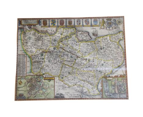
Lot 158
After John Speed 1552-1629 British A 17th century hand coloured engraved map '' Bieknoke'' engraved by Henry Hondius and published by Sudbury and Hamble, damaged, 37 x 51cm, framed and After Christopher Saxton 1540-1610 British, a 17th century engraved map of Radnor, engraved by William Kip, 28 x 33cm, framed
Lot 52
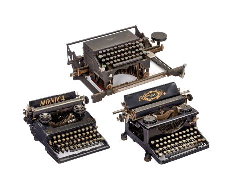
3 mechanische Schreibmaschinen1) "Elliott Fisher", um 1920, Oberanschlag-Buchschreibmaschine mit Laufrahmen für Journal-Buchführung, Mechanik hakt, müßte gereinigt werden. - Literatur: Martin, 1949, S. 164. (4/4) - 2) "Monica", 1927. Seltene deutsche Reiseschreibmaschine. (3/3) - Und: 3) "MAP", 1921, französische Vorderanschlagmaschine der "Manufacture des Armes de Paris". (3/2-) Start Price: EUR 80 Zustand: (-/-)3 Mechanical Typewriters1) Elliott Fisher, c. 1920, downstroke book typewriter for typing on horizontal surfaces, mechanism sticks, in need of cleaning. - Literature: Martin, 1949, p. 164. (4/4) - 2) Monica, 1927, rare German portable typewriter. (3/3) - And: 3) MAP, 1921, French frontstroke machine by Manufacture des Armes de Paris. (3/2-) Start Price: EUR 80 Condition: (-/-)
Lot 128
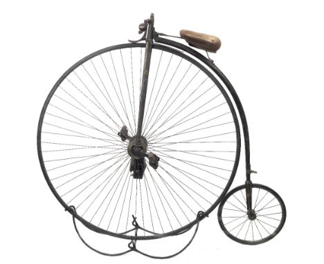
A Singer 52 inch Ordinary bicycle, formerly the property of John William Evans,painted black with traces of coach-lining, tapered spine with footrest, and remains of maker's transfer, sprung saddle pan with replaced cloth cover (worn), drop end handlebars with turned pear grips, simple sprung brake to driving wheel, opposed radial spoking to crescent rim, with solid black rubber tyre, pedals on adjustable cranks, the hub fitted with Lucas patent 2493 hub-lamp, the lens applied with Cyclists Touring Club transfer, 16 inch trailing wheel. Together with folding Ordinary stand, a bicycling map of England & Wales, a leather pouch, remains of saddle leather (in pieces), a rumble bell (lacking strap), a Victorian Cyclists Club cap, a medal presented to J.W.Evans, June 29th 1886, First Prize 10 Mile Handicap by the Chester Falcon Cycling Club, a photograph of J.W.Evans, and a photocopy of a publication depicting Evans with his Ordinary bicycle. This lot is subject to the following lot symbols: ◊◊◊◊ £60 + VAT uplift and storage at £12 + VAT per lot per dayFor further information on this lot please visit Bonhams.com


Lot 205
AN EDWARDIAN MAHOGANY WALL-MOUNTED MAP CASE containing pull-down maps of London (drawn for the Post Office Directory, 1907), 70cm, x 100cm; Environs of London, 70cm x 96cm; and Hackney Carriage Distances from Sussex Gardens, Westbourne Terrace, 94cm x 65cm, the case with a plinth top and 33cm high, 122cm wide.
![[TOPOGRAPHY]. SOMERSET Billingsley, John. General View of the Agriculture of the County of Somerset, with Observations on it](https://cdn.globalauctionplatform.com/7a87d910-9b7b-40c4-bbed-b0a700775427/a593961b-ad62-470a-8bf7-b0a8010fa420/468x382.jpg)
Lot 258
[TOPOGRAPHY]. SOMERSET Billingsley, John. General View of the Agriculture of the County of Somerset, with Observations on its means of Improvement, second edition, by Cruttwell for the author, Bath, 1798, half calf, folding map frontispiece, one folding plan and one plate illustration (as called for), bookplate for Sir Rd Bempde Johnstone, Baronet, octavo. Condition Report : Neat ink notes to half title page verso. Condition reports are offered as a guide only and we highly recommend inspecting (where possible) any lot to satisfy yourself as to its condition.
![[TOPOGRAPHY]. SOMERSET Rutter, John. Delineations of the North Western Division of the County of Somerset, and of its Antedi](https://cdn.globalauctionplatform.com/7a87d910-9b7b-40c4-bbed-b0a700775427/8268fe37-cbb3-4181-8b16-b0a8010fa50a/468x382.jpg)
Lot 259
[TOPOGRAPHY]. SOMERSET Rutter, John. Delineations of the North Western Division of the County of Somerset, and of its Antediluvian Bone Caverns, for the author / Longman et al., London, 1829, full leather, frontispiece, vignette title, a further thirty-seven engraved and other plate illustrations, folding hand-coloured map, further wood-cut vignette illustrations, subscriber's list, octavo. Condition Report : Binding split open between p.x and p.xi. Condition reports are offered as a guide only and we highly recommend inspecting (where possible) any lot to satisfy yourself as to its condition.
![[TOPOGRAPHY]. SOMERSET & DEVON The Homeland Handbooks, No.35: The Quantock Hills, their Combes & Villages, first edi](https://cdn.globalauctionplatform.com/7a87d910-9b7b-40c4-bbed-b0a700775427/45b6ebf6-e456-4391-ade7-b0a8010fa5c5/468x382.jpg)
Lot 260
[TOPOGRAPHY]. SOMERSET & DEVON The Homeland Handbooks, No.35: The Quantock Hills, their Combes & Villages, first edition, 1904, green cloth, illustrations, advertisements, complete with folding map in pocket at end; together with The Homeland Handbooks, Nos 35: The Quantock Hills, their Combes & Villages, fifth edition, Frederick Warne, no date; 37: Lynton, Lynmouth and the Lorna Doone Country, eighth edition; 51: Yeovil with its Surroundings, first edition, 1906; and 75: Bude and its Borderland, fifth edition, all with stiff paper covers, illustrations, advertisements and folding maps; also The Homeland Handy Guides, No.22: The Western Mendips, second edition paper covers, illustrations, advertisements, (6). Condition Report : Quantock Hills: lower cover with damp marked fore edge; Lynton: minor loss at base of spine; Yeovil: spine ends torn; map detached. Condition reports are offered as a guide only and we highly recommend inspecting (where possible) any lot to satisfy yourself as to its condition.
![[TOPOGRAPHY]. BRISTOL & SURROUNDING AREA Kelly's Directory of Somersetshire, Gloucestershire and the City of Bristol, 19](https://cdn.globalauctionplatform.com/7a87d910-9b7b-40c4-bbed-b0a700775427/17eb08f4-7d12-41ca-af57-b0a8010fa6bd/468x382.jpg)
Lot 261
[TOPOGRAPHY]. BRISTOL & SURROUNDING AREA Kelly's Directory of Somersetshire, Gloucestershire and the City of Bristol, 1923, red cloth, with map of Gloucestershire (only); together with Kelly's Directory of Bristol, 1935, with map; 1938, with map; and 1953, without map, all red cloth, all quarto. Note: This lot sold with all faults, not subject to return.
![[TOPOGRAPHY]. CORNWALL Fifty-eight assorted works, including Kelly's Directory of Cornwall, 1910, original red cloth, foldin](https://cdn.globalauctionplatform.com/7a87d910-9b7b-40c4-bbed-b0a700775427/e8fee6d3-0ec5-42fe-95a5-b0a8010fad0a/468x382.jpg)

Lot 771B
1920s Plan of First Class Accommodation for the White Star Line R.M.S. Olympic passenger ship, fold out booklet/map printed on thin paper, the plan opens up to reveal a large and detailed inner map of the first class accommodation aboard the Olympic, surrounded by photographs of the interior including cabins and communal areas, dated Feb 1922, approx. 102x75cm


Lot 466
A Georgian hand-drawn map on vellum titled "Map of Ellel Grange, belonging to Miss Cristopherson, 1770", measuring approx. 25.5cm x 22cm Ellel Grange, near Bay Horse, Lancashire, came to be owned by the Sandeman family (Port producers) in the mid-19th century. The current house was constructed in 1858 and is now the headquarters of Ellel Ministries. Together with a Goliath pocket watch by Hamilton & Inches, Edinburgh (2) Condition Report:Available upon request


Lot 307
SUFFOLK INTEREST - a framed page of an Antique atlas or map, depicts Suffolk and the relevant counties including associated crests, reverse appears to be the alternate pages of the associated atlas, with a description of Suffolk and a list of the towns in alphabetical order, and a second framed Antique map of the Suffolk area, largest 56cm x 74cm (2)

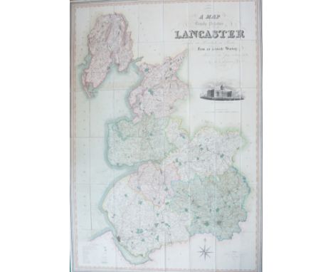
Lot 13
Hennet, George. A Map of the County Palatine of Lancaster, large-scale map engraved by James Bingley, London: Henry Teesdale & Co., 1 May 1830. Dissected, linen-backed, hand-coloured engraving on one sheet, 164 x 115cm, featuring a steel-engraved inset view of New Custom House, Liverpool, housed in a contemporary mottled calf book-form slipcase with oxblood morocco title label lettered in gilt, the map is well-preserved, the green edging material coming loose in places, the slipcase is worn
Lot 15
A miscellaneous collection of dissected & linen-backed maps to include three maps of the Midlands, covering parts of Gloucestershire, Worcestershire and Northamptonshire, Sheet Nos. 25, 31 & 32, London: G. & J. Cary, 1832, hand-coloured, each sheet measuring approx. 56.5 x 68.5cm, housed in two slipcases; A New Map of the County of Salop, London: C. Smith, 1818, hand-coloured, housed in slipcase; City of Dublin, Sheet No. 18, Ordnance Survey, 1849, approx. 65 x 98cm; Yorkshire, Sheet Nos. 193 & 194, Ordnance Survey, 1855, each sheet measuring approx. 65.5 x 97.5cm, housed in a slipcase bearing label for 'James Wyld, Geographer to Her Majesty'; Lancashire, Sheet XXI, Ordnance Survey, 1895, approx. 69 x 102cm, and others, including Sussex, Bath & Wells, Wakefield & Pontefract, plus six later maps (17)
Lot 115
Photography & Postcards. An archive to include carte-de-visite portraits of Queen Victoria, Prince Albert, Gladstone, Derby, Palmerston, and others, including more generic family portraits, 177 in total, some cabinet cards, arranged in two worn albums; postcards in four albums, including a good range of real photographic, many relating to Lampeter & Aberystwyth, including sports (rugby & athletics), WW1, theatrical, university, group portraits; five Edwardian mounted photographs of classes at Lampeter School; a small photograph album belonging to James Bell Whitworth [Cambridge don], two loose photographs of the same during his university days, an unused photograph album awarded to same, and his university cap or mortarboard; a rolled panoramic group photograph of The Grammar School for Girls, Cambridge, October 1968; The Tube-Bus Guide to London and a Bus Map, No. 4, 1935, and a hand-coloured aquatint etching of the Botanic Garden, by Stadler & Westall, 1815, framed & glazed, the whole in one carton
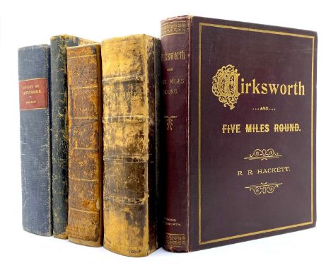
Lot 94
Derbyshire History & Topography. A miscellaneous collection of books to include Wirksworth and Five Miles Round, by R. R. Hackett, large paper edition numbered 18/75, Wirksworth: F. W. Brooks, 1899, small quarto, publisher's gilt cloth, illustrated with real photographic plates; A New Historical and Descriptive View of Derbyshire, by Rev. D. P. Davies, Belper: S. Mason, 1811, illustrated with five plates (three folding), including hand-coloured map frontispiece, bearing armorial bookplate for Thornbridge Hall, octavo, full calf, crudely re-backed; The History of Buxton, by A. Jewitt, Yorkshire: Published by the Author, 1816, vignette title, four plates inc. frontis., vignette supplement leaf, worn half morocco; History, Gazetteer and Directory of Derbyshire, by Samuel Bagshaw, Sheffield: S. Bagshaw, 1846, rebound in blue buckram; History, Gazetteer and Directory of the County of Derby, Leeds: Francis White, 1857; The Derby Almanac & Diary for 1924; Recollections of Matlock & Neighbourhood, London: Newman & Co., [c. 1870]; A New Map of the County of Derby, hand-coloured copper engraving, linen-backed, 53 x 46cm, London: J. Wyld, 1838, housed in pebble-cloth slipcase bearing paper title labels; six children's books published by the Religious Tract Society, each bearing a gift inscription to William Moorcroft from the Hatton Wesleyan Sunday School, 1886-90; an auction catalogue for Milford House, Derbyshire, 1938; two bound volumes of Belper Parish Magazine, 1891 & 1896. Together with a small quantity of modern local history & reference. Condition varied, sold as one collection with all faults, in one carton
![Kinneir, John Macdonald. Journey Through Asia Minor, Armenia, and Koordistan, first and only edition [one of 750], London: Jo](https://cdn.globalauctionplatform.com/cc4f721d-af13-41e8-85f4-b0a500d992bd/ec311788-5f93-49b7-9130-b0a7010be2cf/468x382.jpg)
Lot 33
Kinneir, John Macdonald. Journey Through Asia Minor, Armenia, and Koordistan, first and only edition [one of 750], London: John Murray, 1818. Octavo, half crushed morocco, rebacked with the original spine laid down, later endpapers, pp. x, 603, separate folding map (dissected & linen-backed), published by Arrowsmith, 3 December 1817, measuring 51.5 x 84cm, a loosely inserted fax from publisher John Murray stating that '750 were published and there were no further editions.' Main contents generally good with handling marks and some early annotation, occasional spots & marks, title with marginal wear & small repair, binding tight & square with wear to extremities, lacking half-title. Housed in a bespoke clamshell box with a folding shelf to hold the map. Scarce
![Taylor, Alexander [Surveyor]. Manuscript plans of Knockando in Moray, Scotland, surveyed in 1774. Comprising 14 linen-backed,](https://cdn.globalauctionplatform.com/cc4f721d-af13-41e8-85f4-b0a500d992bd/ef68c7a3-dbbd-4727-b5d5-b0a7010b3f19/468x382.jpg)
Lot 5
Taylor, Alexander [Surveyor]. Manuscript plans of Knockando in Moray, Scotland, surveyed in 1774. Comprising 14 linen-backed, double-page maps, entirely hand-drawn in ink & watercolour on laid/chain-lined paper, each map measuring 54 x 74cm, each signed by Taylor. 1: Plan of the Farm of Clune; 2: Plan of the Farms of Balna Clach & Alt Winny; 3: Plan of the Farms of Knockanagore & The Lyn; 4: Plan of the Glebe Borlum & William Garrow's Improvement; 5: Plan of Milntown, Croften Lone & Knockanreich; 6: Plan of Bogg Chur & Upper Strondow; 7: Plan of the Tulishk Improvement; 8: Plan of the Leggans, Garroline More & Garroline Begg; 9: Plan of Knock Churn, Nether Knockans, Upper Knockans & Lynachurn; 10: unknown, pencil outline only; 11: Plan of the Farms of Upper & Nether Tandow; 12: Plan of Keradow, Cardinach & Nether Borlum; 13: Plan of Drum Divan & the Burntland Improvements; 14: Plan of the Mains of Knockandow; 15: Plan of Tam More. The condition on the maps is varied, some have handling marks, creasing, wear & loss, others are better preserved, all housed in a worn half-calf folio volume, boards detached. A unique record and remarkable piece of Scottish history (14)


Lot 10
Kanarek & Lipski. Poloniae, a pictorial nature map of Poland created for the 1939 New York World's Fair, subsequently censored, withdrawn and destroyed due to its anti-Nazi and anti-Soviet Russia imagery, thus very scarce. Warsaw: Control Board of State Forests, Published for Private Circulation, 1938. 34 x 45cm. Framed & glazed, bearing Rowley Gallery label verso. Fold-lines as issued, some discolouration and staining, unexamined out of frame

Lot 29
Tolkien, J. R. R. The Fellowship of the Ring, second impression, London: George Allen & Unwin Ltd., 1954. Octavo, publisher's red cloth lettered in gilt, unclipped dust-jacket. Internally very good & bright, small marks on a couple of pages, folding map at rear well-preserved, binding tight & square, a few white spots to cloth, dust-jacket discoloured & worn


![Robert Morden (c. 1650 - 1703), two-page map, Darbyshire [sic, Derbyshire], early-mid 18th century, hand-coloured copperplate](https://cdn.globalauctionplatform.com/4b685b92-937f-49e8-876a-aff100944dab/7a61416c-8005-400e-b2b5-b09a0126d436/468x382.jpg)

-
109198 item(s)/page