We found 109182 price guide item(s) matching your search

Refine your search

Year

Filter by Price Range
  • List
  • Grid
  • 109182 item(s)
    /page

Lot 622

EVANS, Rev. J. & BRITTON, J. The Beauty of England and Wales or Delineations, Topographical, Historical, and Descriptive of each County, London, 1810. (Monomouthshire- 7 plts. Norfolk - 20 plts. 1 vig. Northamptonshire - 4 plts.) Marbled bds. worn. lacks backstrip. Tog.with Vol. XII Part II. BRITTON, John, & BRAYLEY, Edward, (eds.) Oxfordshire , 1813, by J.N. Brewer, ( 19 plts.) bound with Rutlandshire (4 plts.) worn bds. lacks backstrip. Plus Wiltshire, Frontis. folding map. & engrd. tp. 18 plts. Uncovered bds. Rebacked cl. 3

Lot 628

COBBETT, William, Rural Rides, Peter Davies , 1930. 8vo. in 3 vols. ed. C.D.H. & Margaret Cole. Vig. by John Nash. edpp. map by A.E. Taylor. 1/4 cl. in 3 vols. 3

Lot 631

KITTO, John, The History of Palestine from Patriachal Age to the Present Time, ed. Alexander Reid, A & C Black, 1844. 8vo. folding map. det. cl. bd. Tog.with NANSEN, Fridtjof, ""Farthest North"", Newnes, 1898. 8vo. dec. glt. cl. in 2 vols. 3

Lot 633

LONGMANS, (pub.) Excursions in The County of Norfolk: comprising A Brief Historical & Topographical Delineation of Every Town & Village, London, 1818, sm. 8vo in 2 vols. Frontis map, numerous plts. glt. leather. Tog.with 6 other volumes, uniformly bound; Essex (2), Sussex, Surrey & Suffolk (2), each with folding map and plts. Ex. Lib, with library number on bds. Bkplts. 7

Lot 636

SAVAGE, James, History of The Hundred of Carhampton in the County of Somerset, Strong, Bristol, 1830. 4to. frontis. folding cold. map. 1/2 glt. bds. Tog.with EVANS, Rachel, Home Scenes: or Tavistock & Its Vicinity, Simpkin & Marshall, 1846. 8vo. frontis foxed. A.e.g. glt. bds. scuffed. Plus PAGE, John Ll. W. The Rivers of Devon from Source to Sea, Seeley & co. 1893. 8vo. frontis with tissue guard. Drawn by A. Ansted. lacking 1 etching. folding map. glt. cl. Plus The Coast of Devon & Lundy Island, by same, Horace Cox, 1895. 8vo. plts. a.c.f. maps at rear. glt. cl. owners insc. Plus other Somerset & West Country interest. 17

Lot 642

HUC, M. Souvenirs D`une Voyage dans La Tartarie, Le Thibet et La Chine, pendant les annees 1844, 1845 & 1846, Paris, 1850. 8vo. in 2 vols. Frontis. map. 1/2 bds. det. in vol. 1. Tog.with The Chinese Empire forming A Sequel to the Work entitled ""Recollections of a Journey through Tartary & Thibet"", by same. in 2 vols. Longman, 1855. 8vo. frontis. map. cl. bds. 4

Lot 648

GRAY, John Henry, China. A History of The Laws, Manners and Customs of The People, ed. William Gow Gregor, Macmillan, 1878 in 2 vols. 8vo. T.e.g. pict. cl. worn. Tog.with NORMAN, Henry,The Real Japan, Fisher Unwin, 1892, 2nd. edn. Glt. bds. worn, plus other topography, inc. 3 Baedekers. (Egypt, 1914, frontis. map, The Mediterranean, 1911, frontis. map with tear and annot. Paris, 1907. lacks frontis map.) 10

Lot 649

SLATIN PASHA, Rudolf, C. Fire and Sword in The Sudan, A Personal Narrative of Fighting and Serving The Dervishes 1879-1895. Trans. Major F., Wingate. Ills. R. Talbot Kelly. Arnold, 1896. 2nd. edn. 4to. Frontis. det. Plts. a.c.f. Folding map. T.e.g. Glt. cl. worn, inner joint weak. Tog.with ROYLE, Charles The Egyptian Campaigns, 1882-1885, and Events which led to them. Hurst & Blackett, 1886. in 2 vols. 3 folding maps. bds. loose in vol. 2. Glt. cl. Plus LANE, Edward,William, An Account of The Manners and Customs of The Modern Egyptian, ed. Edward Stanley Poole, Murray, 1860/ 4tp. full cf. worn. plus similar interest. 18

Lot 523

After O W Brierley, Attack of the Vanguard, Art Union of London 1885, 52 x 86cm, Audrey Hammond, Sudely Castle, signed print, Islands of the Atlantic map, and further prints

Lot 494

JOHN OGILBY, Road Map of Exeter to Truro, plate no 69, hand coloured, ROBERT MORDEN, Map of Dorsetshire, hand coloured and RICHARD BLOME, A Mapp of Wiltshire, hand coloured

Lot 495

SAXTON & MOLE, Map of Herefordshire, hand coloured, 1637, ROBERT MORDEN, Map of Herefordshire, hand coloured and JANNSEN, Map of Herefordshire, hand coloured, double sided (3)

Lot 497

JOHN SPEED. Worcestershire Described, engraved map coloured, 16 x 20 1/2 in; and an engraved coloured map of Warwickshire; two (2)

Lot 586

A large early 20th Century Map of Bromyard and surrounding area, dated 1904, 53 x 78in

Lot 1084

An Australian bronze 23 piece puzzle by Ilaria Logi, each piece modelled as a species of Australian animal, making a map of Australia, in cork box with Eucalyptus leaf top, Ltd. Ed. no.258/760, 11 x 12 cm overall

Lot 121

A 19th century hand-coloured map engraving of Cornwall by Robert Morden, 36 x 42 cm

Lot 171

Thomas Kitchin, Map of Leicestershire, hand-coloured and various prints, (a box).

Lot 175

John Cary, Map of Leicestershire, hand-coloured county map, other county maps, a folio of maps and other prints.

Lot 327

Map of America with the Latest Discoveries - 1795, and a collection of world maps.

Lot 442

Hand-coloured map, "America" and two other framed maps of North America, (3).

Lot 460

Robert Morden, "Leicestershire", small hand-coloured county map and four other small maps, (5).

Lot 462

Bowles`s New Medium Map of Leicester and Rutland, hand-coloured and four other maps of Leicestershire, (5).

Lot 463

William Kip After Christopher Saxton, "Lecestriae", hand-coloured county map of Rutland and two prints of local interest, (4).

Lot 466

After H. Moll, "Leicestershire" hand-coloured county map and two others, (3).

Lot 1321

19th Century hand coloured map of Redhill together with a 19th Century map of Reigate Castle

Lot 1577

Antique hand coloured map of Radnorshire with coloured cartouches to the corners

Lot 1578

John Speed, antique hand coloured map of Pembrokeshire with coloured street plans and crests to the corners

Lot 432

Quantity of military related booklets on submarines, targets attacked in Germany and others, a cycling and motoring map of Evesham, a Central London map, Ordnance Survey map of North Wales and a Geographier plan of Birmingham

Lot 697

E.G Perman - London Underground - A Summer 1928 `Railways of London - Map of the Electric Railways of London` paper map, with tube map to one side and tourist attractions to the other, printed Waterlow & Sons

Lot 831

A WMF matchbox cover with embossed map of The Cape Peninsula, length 6cms

Lot 9

AFTER CHRISTOPHER SAXTON AND WILLIAM HOLE "Oxoniensis Commitatus Volgo Oxfordshire Qui Pars Olim Dobunorum", hand-coloured engraved map, coloured strapwork cartouche within birdseye maple frame, 27 cm x 29 cm (ILLUSTRATED)

Lot 10

AFTER JOHN SPEEDE "Devonshire with Excester described and the Arms of Such Nobles as Haue Borne the Titles of Them", hand-coloured county map with town plan and armorials, 38 cm x 51 cm (ILLUSTRATED) CONDITION REPORTS Overall with wear, scuffs and some stains and discolouration and dirt. Some repairs including patched/ filled repair in the area of Boyton. Some repaired tears including quite a large tear emanating from top right corner of the plan of Excester. Plus further splits and tears including to lower area of the plan and centre top of map, etc. Repair which appears to have been patched to the Colridge Hund. plus various other small splits and repairs. These appear to have been well done and colours are reasonably well matched on the whole. Various well repaired splits and tears to central areas of map, edges, etc. Frame with various areas of chips and loss and has been repainted.

Lot 11

"Southerlandia", hand-coloured map with text verso, image size 38 m x 53 cm, and AFTER PETRUS KAERIUS COELAVIT "Part of Scotland It is called of the inhabitance Stranauerne with his borderers", with text verso "Scotland's generall description", framed and glazed, 9 cm 13 cm (2) (ONE ILLUSTRATED)

Lot 1

A metal Michelin motoring map of England

Lot 715

A 17th century map of the Country of Derbyshire, 53 x 64 cm

Lot 716

John Ogsby, The Continuation of the Road from York to Chester, framed map, 43 x 55 cm

Lot 191

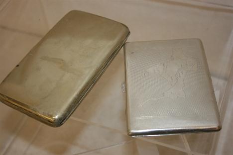
A SOLID STERLING SILVER ENGINE TURNED CARD CASE WITH A MAP OF THE INDIAN CONTINENT TO THE TOP TOGETHER WITH A SILVER PLATED CIGARETTE CASE INSCRIBED TO L J PAYNE ON WAR SERVICE FROM HIS COLLEAGUES AT THE MINT CHRISTMAS 1916

Lot 2442

A New and Complete History and Survey of the Cities of London and Westminster, by Henry Chamberlain, 1769, with engraved plates and one folding map, (rebound)

Lot 342

William Mount (died 1769) and Thomas Page (died 1762) - engraving - "A Large Draught of the Downes" 16.75ins x 21.5ins - Map of the Downs off the coast of Kent, and Jack Nicholas Bellin (1703-1772) - Engraving - "Carte Reduite de la Rade de Dunes" - Map of the Downs off the coast of Kent, 22.5ins x 16.25ins, dated 1757, both in ebonised frames and glazed

Lot 349

John Speed (1552-1629) - Engraving - "Surrey - Described and Divided into Hundreds" - Map of the County of Surrey with views of Richmond and Nonsuch Palaces, 15ins x 20.5ins, published by John Sudbury & George Humble, 1611-1623 (watercolour outlining edge of Hundred, slight split around centre fold top and bottom and some discolouration), in narrow oak frame and glazed

Lot 836

A framed and glazed French map of Africa, 20th century, 115cm high; with framed and glazed plates for Chinese Government 5% re-organistion gold loan of 1913, 79cm wide, (2).

Lot 861

A French ivory and gilt metal stadiometre geographique map instrument, 19th century, with various scales to include France, Prusse, Belgique, Italie, Suisse, Russie, Autriche, Angleterre, bearing name General Chabaud La Tour, 14.5cm high, (cased); with an English cased Captain Field`s gilt metal and wooden improved map instrument, 45cm high, (cased); a Swiss gilt metal compass by Charles Stichling, (cased), (3).

Lot 642

A Nottingham Extension map, showing existing boundaries and proposed extended boundaries of City, Ministry of Health, session 1920, approximately 230cms x 237cms

Lot 758

A quantity of decorative pictures, including two reproduction prints of 18th century hot air balloons, a print map of `Village Lane, Washington, 1895`, and four reproduction prints of medieval biblical and hunting scenes, and a small quantity of books and a map (36)

Lot 79

Fifteen-Drawer Deal Entomological Cabinet by J T Crockett of London, glazed door with lock and key, 51cm by 102cm by 45cm, drawers on stretchers with tight fitting glazed lids, containing a collection of British and European Butterflies, including series of White Admiral, 2 Purple Emperors, Map, Fritillaries, Browns and Vanessids from 1940 to 1980 See illustration With Class Licence CL07/2012/30

Lot 376

After Rapkin, a framed and glazed map of Holland, published by the London Printing & Publishing Company, together with a Hogarth famed and glazed map of Denmark, taken from the Danish Map, published at Copenhagen.

Lot 394

A hallmarked silver map of Great Britain, produced by the Council for the Protection for Rural England, in a simulated mahogany glazed frame.

Lot 411

A small quantity of framed and unframed pictures and prints, including: two Pears prints, a reproduction map of Yorkshire and other items.

Lot 229

The Honorable George Elphinstone, R.N. - Logs of H.M Ships Orion and Cambrian - half-calf handwritten log including a track chart of the Caribbean and map of Canton River from Lankeet to Canton - November 1854-October 1862

Lot 307

John Speede - `Rutlandshire with Oukham and Stanford` - sold by John Sudbury & George Humbell - 39x50cm uncoloured map

Lot 379

A Wells Fargo & Co Express Carriers copper change dish with engraved map of the USA, `Ocean to Ocean` - diam 16cm

Lot 755

A wooden tray, reproduction map, two bookplate maps, vintage newspapers, a shuttle and a bedpan (quantity)

Lot 1503

A 19th century map of Cumberland, a map of Nottinghamshire, Punch books, a pair of binoculars, prints and a brass scales stand

Lot 1506

A hand tinted map of Warwickshire, together with a hand tinted map of The Isle of Wight 1844 and another map of The Isle of Wight (3)

Lot 553

Six: Two WAR MEDALS, Two DEFENCE MEDALS , 1939 - 45 STAR, PACIFIC STAR, and an original medal postal Box, all un-named, a silk Head Scarf printed with an map of India and embroidered `Remember Me`, and two silk Handkerchiefs

Lot 405

ROBERT MORDEN; a hand coloured Map "Britannia Saxonica". 14 1/2" (37cms) x 12" (31cms).

Lot 406

J Cary; a Map of the East Riding of Yorkshire, 16" (42cms) x 20 1/2" (52cms).

Lot 430

A 17th/18th century hand coloured map North West Wales & Anglesey, 15" x 21", framed and glazed back and front

Lot 633

A road map after John Ogilby of the road from London to Boston in Lincolnshire, 33cm x 43cm

Lot 1203

A modern coffee table with inset map decoration

Lot 1348

A quantity of various pictures and prints, framed map etc.

Loading...Loading...
  • 109182 item(s)
    /page

Recently Viewed Lots