![[COLLINGWOOD, Bruce J.] Lapidarium Septentrionale: or, A Description of the Monuments of Roman Rule in the North of England.](https://cdn.globalauctionplatform.com/daa14a7b-b494-41c6-b9a8-aecf00a30373/02ce63ba-ef35-4729-9681-aed300aef0fa/468x382.jpg)

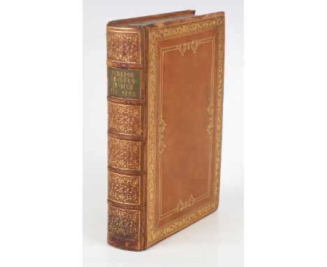
[COLLINGWOOD, Bruce J.] Lapidarium Septentrionale: or, A Description of the Monuments of Roman Rule in the North of England. London: Bernard Quaritch, 1875. Folio (368 x 233mm.) 15 plates, including a large folding map of Northumberland in rear pocket, several chromolithographed and 2 double-paged plates, numerous illustrations in the text. (Spotting to preliminaries and rear leaves, toning, hinges reinforced, newspaper cutting mounted to initial blank.) Contemporary red half morocco, pictorial gilt to upper cover, t.e.g. (rebacked, rubbing to all extremities). Provenance: Frederick Walter Denby (armorial bookplate to the front pastedown); Florence Snowball(?) (gift inscriptions on paper mounted to initial blank).Buyer’s Premium 24.5% (including VAT @ 0%) of the hammer price. Lots purchased online via the-saleroom.com will attract an additional premium of 5% (including VAT @ 0%) of the hammer price.
We found 109198 price guide item(s) matching your search
There are 109198 lots that match your search criteria. Subscribe now to get instant access to the full price guide service.
Click here to subscribe- List
- Grid
-
109198 item(s)/page
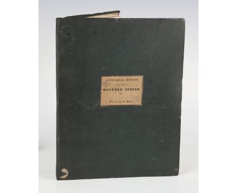
GEOLOGY. - P.I. MARTIN. A Geological Memoir on a Part of Western Sussex; with Some Observations Upon Chalk-Basins, the Weald-Denudation, and Outliers-by-Protrusion. London: John Booth, 1828. First edition, 4to (286 x 213mm.) Folding hand-coloured engraved frontispiece map, folding table, 3 hand-coloured plates to rear. (Small repair to map and a marginal tear, small tear and crease to table, creasing to front blank, toning, offsetting to title, upper hinge broken.) Original blue cloth, paper label mounted to upper cover (bumped to extremities, occasional scuffing). Provenance: John Roe (name inscribed to the initial blank); by descent, from the estate of Rendel Williams.Buyer’s Premium 24.5% (including VAT @ 0%) of the hammer price. Lots purchased online via the-saleroom.com will attract an additional premium of 5% (including VAT @ 0%) of the hammer price.
WOODWARD, Samuel. An Outline of the Geology of Norfolk. Norwich: by John Stacy for Longman's & Co., 1833. First edition, 8vo (222 x 135mm.) 1 hand-coloured folding map, 1 hand-coloured folding section of the Norfolk cliffs, 5 uncoloured lithographed plates to rear. (Lacking the plan, spotting to the uncoloured plates, toning.) Near contemporary cloth, paper label to spine (rubbing to extremities, some loss to label). - And a further six volumes related to the geology of specific areas (including J.W. Robberds' 'Geological and Historical Observations on the Eastern Vallies of Norfolk', 1826, 8vo, and William Pengelly's 'The Lignite Formation of Bovey Tracey, Devonshire', 1863, 4to, and Henry T. de la Beche's 'Report on the Geology of Cornwall, Devon, and West Somerset', 1839, 8vo). Provenance: by descent, from the estate of Rendel Williams (7).Buyer’s Premium 24.5% (including VAT @ 0%) of the hammer price. Lots purchased online via the-saleroom.com will attract an additional premium of 5% (including VAT @ 0%) of the hammer price.
MURCHISON, Roderick Impey. The Silurian System, founded on Geological Researches in the Counties of Salop, Hereford, Radnor, Montgomery, Caermarthen, Brecon, Pembroke, Monmouth, Gloucester, Worcester and Stafford. London: John Murray, 1839. 2 vols. [including 'Atlas' volume], 4to (311 x 240mm.) 6pp. list of subscribers, 56 plates, including 31 lithographed plates of fossils, 10 hand-coloured lithographic folding sections, 2 engraved maps, 13 lithographed plates including 2 hand-coloured, and 1 folding. (Heavy damp-stain to first four plates and to the fossil plates, browning to folding plates, toning, lacks large separate geological map.) Contemporary red half straight grain morocco over marbled paper-covered boards (rubbing, some loss to marbled paper). Provenance: Jos Newill (name inscribed to front pastedown, gift inscribed to on title); by descent, from the estate of Rendel Williams (2).Buyer’s Premium 24.5% (including VAT @ 0%) of the hammer price. Lots purchased online via the-saleroom.com will attract an additional premium of 5% (including VAT @ 0%) of the hammer price.
YOUNG, Arthur. General View of the Agriculture of the County of Norfolk. London: for G. and W. Nicol et al., 1804. First edition, 8vo (208 x 126mm.) Folding hand-coloured map of Norfolk as frontispiece, half-title, 6 engraved plates, 9 folding tables. (Occasional spotting, especially to plate 6, browning to preliminaries, pencil marks to margins, some creasing to tables.) Contemporary calf, red morocco lettering piece to the spine (light rubbing). Provenance: John McDowall (armorial bookplate to the front pastedown). - And a related volume (John Tuke's 'General View of the Agriculture of the North Riding of Yorkshire', 1800, 8vo) (2).Buyer’s Premium 24.5% (including VAT @ 0%) of the hammer price. Lots purchased online via the-saleroom.com will attract an additional premium of 5% (including VAT @ 0%) of the hammer price.
MOUNTAINEERING. - James D. FORBES. Travels Through The Alps of Savoy and Other Parts of the Pennine Chain with Observations on the Phenomena of Glaciers. Edinburgh: Adam and Charles Black, 1843. First edition, 8vo (247 x 159mm.) 12 lithographed plates, 5 tinted, 2 maps including 1 folding map on linen of the 'Mer de Glace of Chamouni'. (Several maps damp-stained and also to the linen of folding map, toning.) Near contemporary brown morocco with scrolling gilt borders, green morocco lettering piece to the spine (rubbing to extremities). Provenance: by descent, from the estate of Rendel Williams.Buyer’s Premium 24.5% (including VAT @ 0%) of the hammer price. Lots purchased online via the-saleroom.com will attract an additional premium of 5% (including VAT @ 0%) of the hammer price.
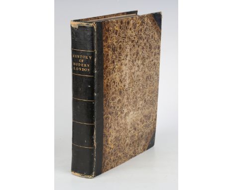
PHILLIPS, Richard (publisher). Modern London; being the History and Present State of the British Metropolis. London: Richard Phillips, 1804. 4to (266 x 198mm.) 54 plates, including 31 hand-coloured etched plates of London trades, and 23 black and white engraved plates with a folding panorama of London and a folding map, descriptive leaf to each hand-coloured plate, 7pp. index, 2pp. 'List of Copper Plates', 1p. publisher's advertisement verso. (Spotting to the folding plates and margins of the uncoloured plates, browning, sometimes heavy, offsetting to descriptive leaves, spotting to preliminaries.) Contemporary black half straight grain morocco over marbled paper-covered boards (rubbing to extremities). Note: first issue hand-coloured plates. [Tooley, 370.]Buyer’s Premium 24.5% (including VAT @ 0%) of the hammer price. Lots purchased online via the-saleroom.com will attract an additional premium of 5% (including VAT @ 0%) of the hammer price.
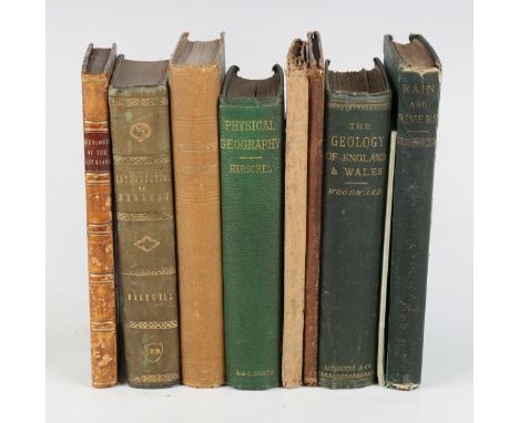
CUNNINGHAM, Robert James Hay. Essay on the Geology of the Lothians. Edinburgh: Neil & Company, 1838. First edition, signed and inscribed by the author, 8vo (216 x 125mm.) Folding engraved hand-coloured map, 16 hand-coloured etched plates, an 'Explanation of the Colours' leaf. (Minor spotting to front and rear leaves and to pastedowns, toning.) Contemporary half calf over marbled paper-covered boards, red morocco lettering piece to the spine (rubbing to spine panel and extremities). - And a further eight related volumes (including the third edition of Robert Bakewell's 'An Introduction to Geology', 1828, 8vo, and John Phillips' 'The Rivers, Mountains, and Sea-Coast of Yorkshire', 1853, 8vo, and John F.W. Herschel's 'Physical Geography of the Globe', 1867, 8vo). Provenance: by descent, from the estate of Rendel Williams (9).Buyer’s Premium 24.5% (including VAT @ 0%) of the hammer price. Lots purchased online via the-saleroom.com will attract an additional premium of 5% (including VAT @ 0%) of the hammer price.
GEOLOGY. - H.T. De La BECHE (editor and translator.) A Selection of Geological Memoirs Contained in the Annales Des Mines, written by Brongniart, Humboldt, Von Buch, and Others. London: William Phillips, 1836. 8vo (228 x 129mm.) 3 engraved hand-coloured folding maps, 9 folding lithographed plates. (2 folding maps replaced in facsimile, including the 'Sketch of a Geological Map of France…and Some Other Neighbouring Countries' by J.J. D' Omalius D' Halloy, toning, occasional spotting, lacking half-title.) Original green blind-stamped cloth (minor stain to upper cover, endpapers replaced). Provenance: by descent, from the estate of Rendel Williams.Buyer’s Premium 24.5% (including VAT @ 0%) of the hammer price. Lots purchased online via the-saleroom.com will attract an additional premium of 5% (including VAT @ 0%) of the hammer price.

° ° Milne, A.A - Winnie-The-Pooh. First Edition. num. illus (some full page, by Ernest H. Shepard), half title, pictorial map on e/ps.; original gilt-pictorial green cloth & gilt top, cr.8vo. 1926; Milne, A.A. - The House at Pooh Corner. First Edition. num. illus. (some full-page, by Ernest H. Shepard), half title, pictorial e/ps.; original gilt-pictorial pink cloth, cr.8vo. 1928; Milne, A.A. - Now We Are Six. First Edition. num. illus. (some full-page, by Ernest H. Shepard), half title; pictorial e/ps.; original gilt-pictorial red cloth, cr.8vo. 1927; sold with 2 other books by this author


Asia - John Speed (1552-1629), Asia with the lands adjoyning described, the atire of the people and townes of importance all of them newly augmented by J.S., Ano Dom: 1626, George Humble, hand coloured engraved ‘carre-a-figures’ map with ten costumed figures to the vertical margins and eight oval vignettes of principal cities along the upper margin, 39.5 x 51cms., framed.


Wyld, James - Spain and Portugal, a set of 4 linen backed folding maps, coloured in outline, c.1820, 66 x 97.5cms., in worn slip case, together with Vivien de Saint-Martin, Louis - Carte des Royaumes d’Espagne et de Portugal, a folding linen backed map, coloured in outline, Paris, dated 1843, 83.5 x 10⁹cms., in slip case.
![° ° Blaeu, Jan. De cust van Engelandt tuschen de Singels en de drooghten van Weembrugh, [Sussex coast from Arundel to Rye], e](https://cdn.globalauctionplatform.com/2b6438f4-45a6-4db6-ac1b-aecb00aa9e49/6c128d7f-8d5a-44f9-8962-aecb00af9861/468x382.jpg)
![° ° Norden, John. - Sussexia, engraved hand-coloured map of Sussex, framed and glazed, [1637], (image 22 x 39cms.) [Seale?]](https://cdn.globalauctionplatform.com/2b6438f4-45a6-4db6-ac1b-aecb00aa9e49/353adf75-28b8-4a7d-a779-aecb00af977d/468x382.jpg)
° ° Norden, John. - Sussexia, engraved hand-coloured map of Sussex, framed and glazed, [1637], (image 22 x 39cms.) [Seale?] A correct chart of the German Ocean [i.e. North Sea]... for Mr Tindal’s continuation of Mr Rapin’s History, hand-coloured, framed and glazed, 1742-47, (image 47 x 37cms.) (2)
° ° Fox, John - Acts and Monuments of Matters of Most Special and Memorable, Happening in the Church.... Whereunto are annexed certain additions..... to which also is added the Life of the Author.... the ninth edition, vols 1 & 2 bound together (of 3). portrait frontis., 4 engraved plates, map and num. other text engravings; disbound and distressed, binding broken and some leaves loose, folio. printed for the Company of Stationers, 1684


° ° European Travel - Baxter, William Henry - Impressions of Central and Southern Europe, 8vo, calf, ink presentation inscription to front fly leaf, early and final leaves spotted, Longman, Brown, Green and Longmans, London, 1850; Curzon, Robert - Armenia, 3rd edition, 8vo, half calf, with engraved frontis, map and four plates, John Murray, London, 1854 and Moor, Henry - Visit to Russia in the Autumn of 1862, 8vo, original red cloth, with 8 lithograph illustrations, 32 page catalogue at end, ink presentation inscription to front inner board and ownership inscription to title, Chapman and Hall, London, 1863 (3)

° ° Jersey and Channel Island interest - Plees, W - An Account of the Island of Jersey, 4to, rebound blue leatherette, lacking map, Southampton, 1816; Actes des Etats de L’ile de Jersey 1524-1596, Jersey, 1897; Cartulaire des Iles Normandes, Jersey, 1924; Croix, de la - La Ville de St. - Hellier, 8vo, half calf, 1845, bound with - Les Etats, Episode Historique D’une Histoire Inedite de Jersey, 1847; Black, C.B - Jersey, Guernsey, Herm, Sark and Wsetern Normandy, 6th edition, 8vo, blue cloth gilt, London, 1894; Syvret, George S -> Chroniques des Iles de Jersey, Guernsey, Auregny et Sark, 8vo, calf, Guernsey, 1832; another copy, 1858, Eagleston, A.J - The Channel Islands under Tudor Government, 8vo, cloth, Cambridge, 1949; Prynne, William - Rockes Improved, 8vo, calf, boards detached, ‘’William Prynne, late Exile , and close Prisoner in Mount- Orgueil Castle in the Isle of Jersey’’, Michael Sparke, London, 1641 and two modern pamphlets relating to Jersey, (11)


° ° Dodwell, Edward - A Classical and Topographical Tour through Greece, during the years 1801, 1805, AND 1806, 1st edition, Sir John Linton Myers copy, 2 vols, 4to, speckled calf by Rivière, with folding map and 66 plates, including 6 folding and 2 hand-coloured, Rodwell and Martin, London, 1819, together with an a/l, dated 19th December, 1938 from John Linton Myres [1869-1954, OBE., FBS., FRAI, Professor of Ancient Greek at Liverpool and Oxford Universities], to a Mr. Burn [Andrew Robert [Robin] Burn (1902-1991), historian and classical scholar] - ‘’I am very glad the Dodwell has arrived and is welcome. He had to go to the binders to be brisked up for the wedding, as I have had him for many years, and a cat (I think) has tried to study vol II. without removing it from the shelf.Put the enclosed lines [4 lines in ink, in Greek, monogrammed J.L.M and dated 31.12.38, also present] on the fly leaf, if your critical eye passes them. They should have been in the book, but I could not remember whether the second person……in TOV or TYN; but the oracle has spoken today - I hope rightly. With every good wish for you both, yours very sincerely, John L.Myles’’
![° ° [John Field's 1660 Restoration Prayer Book] The Book of Common Prayer, and Administration of the Sacraments ... With the](https://cdn.globalauctionplatform.com/2b6438f4-45a6-4db6-ac1b-aecb00aa9e49/42a393d6-51c1-4d46-8846-aecb00af4cf7/468x382.jpg)
° ° [John Field's 1660 Restoration Prayer Book] The Book of Common Prayer, and Administration of the Sacraments ... With the Psalter, or Psalmes of David. engraved frontis (royal arms, by Hollar), title (with engraved device & within double fleuron border), dedication (signed John Ogilby), engraved headpieces and decorated initial letters, printer's device end of Ordinal (Zlv), some black letter, multi-ruled in red throughout. [Cambridge: printed by John Field], Anno Domini, 1660: bound with the first volume (of 2) of Field's Restoration Bible - The Holy Bible. Containing the Bookes of the Old and the New Testament. pictorial engraved title. double-page map (with 2 others and a plan insert) & 5 other d-page plates, decorated initial letters and double red-ruled throughout; contemp. gilt-ruled and panelled black morocco, the gilt-decorated central panel with onlaid gilt-decorated red morocco lozenge and gilt fleurons at corners, the inner corners of the covers (by spine) with onlaid gilt-decorated red morocco pieces (the outer silver ones, at fore-edge, having been removed), gilt-decorated & panelled spine with red label, silver clasps & gilt edges, folio. Cambridge: printed by John Field, Printer to the Universitie ... 1660

° ° Stanley, Henry Morton, Sir - In Darkest Africa, or the Quest Rescue , and Retreat of Emin, Governor of Equatorial, 1st edition, 2 vols, 8vo, original pictorial cloth gilt, with 4 maps (1st map in vol 1 torn and with loss), 2 photographic frontises, 36 plates and a folding table, occasional foxing throughout, London, 1890

° ° Brydone, Patrick - A Tour through Sicily and Malta. In a series of letters to William Beckford ,Esq. ... First edition, 2 vols, half title, errata leaf; old calf with panelled spines (distressed). 1773; another edition, 2 vols (in one). folded map, half titles; contemp. gilt-ruled tree calf, gilt-decorated spine with red label, 1776

° ° Milne, A.A - Winnie-The-Pooh. 1st Canadian edition. illus (by Ernest H. Shepard), half title, coloured pictorial map on e/ps., publisher's gilt-pictorial cloth. Toronto: McClelland & Stewart, 1926; sold with 6 other books- including Kipling's Debits and Credits (1926); The Naulakha (repr.1908); From Sea to Sea (repr.1914); and 3 miscellaneous others

° ° Stein, Marc Aurel - Ancient Khotan. Detailed Report of Archaeological Explorations in Chinese Turkestan. 2 volumes (in one) SDI Publications, Bangkok, 2001. Faux leather binding, gilt, with gilt corners. In the original cardboard case. *One of a limited edition of 999 copies. Together with; Stein, M. Aurel - Sand-Buried Ruins of Khotan. Personal Narrative of a Journey of Archaeological and Geographical Exploration in Chinese Turkestan. With a Map from Original Surveys and Numerous Illustrations. Facsimile edition published in 2000 by (the) Mushussu Press, 2000. (2)*These two volumes are the finest reproductions of the first editions of 1907 and 1903 both in mint condition.


Grouping of WW2 Military Maps of Mostly Occupied Europe, interesting grouping of geological and survey maps produced on areas of occupied Europe, mostly France, Belgium and Holland. Dates ranging from 1942 – 1944. One map of Brighton and Eastbourne also. Areas include Caen, Gace, Zeebrugge, Oldenburg (Germany), Antwerp, Orbec, plus others. Various conditions and scales. (19 items)
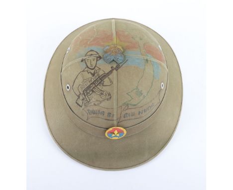
North Vietnamese Army (N.V.A) Pith Helmet, fine green cloth covered pith helmet with badge to the centre. Top of the helmet with drawn artwork showing a Viet Cong soldier with flag and drawn map of the country, scroll with “DUNG SI GIU NUOG”. Liner loose to the interior. Some flaking to the interior.

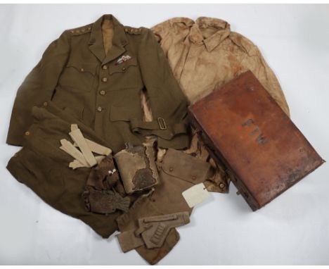
Historically and Regimentally Important Uniform, Paperwork & Equipment Grouping of Major D O Faulkner Royal West Kent Regiment, Taken Prisoner of War in 1940, Made Numerous Escape Attempts and Became the Camp Locksmith, Making Keys so Storerooms Could be Opened to Steal Supplies for Escape Attempts, tunics consist of his Royal West Kent No1 dress tunic which originally was issued to another officer, with brass regimental tunic buttons, rank crown to shoulders and medal ribbons for WW2 and post WW2 service; Royal West Kent regiment officers mess dress uniform with the trousers having some moth damage; post WW2 jungle shirt with regimental slip-on rank slides and cloth formation signs; Royal West Kent regiment field officers No1 dress peaked cap with sterling silver cap badge, regimental forage cap with blue piping to the crown and regimental cap badge; various items of equipment, badges and insignia. Some of the equipment having the name of a different officer, but this was the equipment he was issued with after being released from captivity when he continued to serve in Malaya. Various items of pre-war and post war ephemera relating to him and the regiment. Fine Pre-WW2 photograph album compiled by Major Faulkner of the Royal West Kent regiment in camp and training. Many good photographs in this album showing the troops training in battle dress and steel helmets etc. All bar a couple of the images are believed to have been taken by Faulkner, a pack of negatives also are included with the lot. The most interesting items in the grouping are in what he called his “POW Bag”, these items in my opinion are of incredible historical and social importance and tell the story of his POW life, the first item is a metal handle for a suitcase, but when you look through one end, hidden inside is a tissue paper escape map, the idea being that the case handle would be broken open and then the map removed; an envelope with his name inked, “Denis”, reveals a hand written reconnaissance of the various escape routes which can be taken and gives fascinating insight into what they could do to aid their escape, one extract is as follows, “GERMANY’S WESTERN FRONTIERS – HOLLAND. Apart from VENLO area, which is closely watched, the Dutch station is not well guarded, not difficult to cross.” Later goes on to say, “In the MAASTICHT district it is dangerous to attempt to cross the MEUSE on the ALBERT CANAL, it is better to go due south rather than west into BELGIUM”. This reconnaissance notes covers Holland, Belgium, Luxembourg, Baltic Ports and the Swiss Frontier. The reconnaissance also covers information on Railway Travel, Travel Permits, Travel on Foot and Stowing Away. These five pages of handwritten reconnaissance would have been vital for Major Faulkner, when attempting to escape captivity. Other items in his ‘POW BAG’ include tissue escape map, silk escape maps and an interesting selection of lock picking tools and keys, which were useful to him as he was in charge of picking locks for the escape committee in the camps he was held in. A photograph taken inside a camp is included and also some un-issued WW2 German cloth insignia which he must have picked up whilst in a camp, possibly for use in a escape attempt? Overall this is an incredible grouping and with the escape reconnaissance sheets, which we have never seen before and possibly unique, a truly historic grouping. Sold by direct descent of the family of Major Faulkner. Major Faulkner’s daughter has written the following account about her father, “Like most POWs my father did not talk about his five years as a POW but he considered himself far more fortunate than those who had been Japanese POW’s. His BEF ID card is dated 2.5.1940 and he was captured on 29.5.1940 in “Godversveldt near Hazebrouk” in northern France near the Belgian border. He did say that as prisoners they were first marched through Belgium and that the locals, particularly when they halted for food and water, were unhelpful.He did talk about trying to escape several times and on his release questionnaire he mentions unsuccessful attempts whilst at Biberach and Warburg. The escape from Warburg is detailed in The London Gazette supplement no 37568 dated 17/5/1946 on page 2340 under the details for Flt Lt Peter Stevens RAFVR. He did say that he became downhearted by his failed attempts to escape and found the penalty of solitary confinement very difficult to bear. He concentrated his efforts on making lock picking tools and perfecting the techniques required so that he could help by opening (and closing) locked buildings and store rooms to obtain or examine things needed to improve their lives or for other escape attempts. He said he had to hide the pick locking tools in the wooden frames of his bed at each camp and it was always a struggle to hide anything when they were being transferred between camps. After the war when he did need his pick locking tools we would ask to see his other few POW mementoes which included the paper thin escape map and the suitcase handle which he said contained another very thin escape map within it. We were never allowed to open it up so I can only assume that is what can be seen in it. We are keeping his dog tags and his POW ID card number 547 dated 21.7.1943 for Rotenburg, his last camp but a photo of it is available. There is a set of 5 escape instructions and one refers to travel since March 1942; they are not written by him but were presumably provided to him in preparation for an escape attempt; I do not remember being told anything more about them. In the small photo of POWs my father is in the back row, second from the right hand end.He did speak about the lack of food as it was a daily problem and his questionnaire commends the Red Cross, British Legion in Switzerland and the English in the Argentine for their help with food parcels. He said they were told that they must eat the skins of potatoes as most of the goodness/vitamins were to be found just under the skin and that it was OK to eat mouldy food just as long as the mould was not orange! We were never quite so convinced by this last piece of advice but my mother would always defer to him on whether we should still eat any food that she was not sure about.In August 1980 Flight Lieutenant Roth raised issues about pay having been deducted from POWs against the issue of camp money and my father wrote to his MP about this. In his letter he says that except in the early days at Laufen there was little or nothing to buy with the camp money. His CO had been a prisoner in the first war for a short time and he told them that a proportion of their pay had been withheld but it had been returned after the war. He said this had the effect of devaluing the camp money between prisoners and that for example a tennis ball with camp money cost £200. In Biberach they had put vast quantities of spoil from at least one tunnel in the roofs of the barrack blocks and were subsequently charged a considerable sum for repairs. He was asked by the escape committee in various camps to put in requests for battle dress, particularly trousers as they were required for cutting up to make bags for carrying soil from escape tunnels. The cost of the uniform was deducted from his credits and he thought from his pay at home. Also at various times fuel for their “chip heaters” for cooking ran out and they burned camp money in order to heat food from their Red Cross parcels.
WW2 British Uniform and Equipment Grouping of Captain Francis Tasker Wheeldon Royal Army Medical Corps Attached Special Air Service (S.A.S) in Cairo and Later with the Special Boat Section (S.B.S) on the Greek Islands, superb grouping which still remains in the original leather suitcase with his initials impressed to the lid. Grouping consists of his early Indian made step in paratrooper jump smock with front zip and press stud snaps. The interior of the smock has a name label to the hanger hook in the collar. Smocks is dirty and shows extensive wear. This smock most likely what he was wearing when in Cairo with the Special Air Service on operations; officers Royal Army Medical Corps service dress tunic with brass regimental buttons, officers collar badges and parachute qualification wing worn on the breast in the operational position above his medal ribbons for WW2 service. Interior of the tunic with label to the inside pocket which is well worn but you can just make out “Dr F T Wheeldon” and the date 1942. Accompanied by the officers service dress trousers, these are heavily mothed around the crutch area. Grouping of equipment including open top webbing Webley pistol holster, map case, shirt collars and water bottle etc. The set remains in good untouched as found condition. After his death in 2005, the British Medical Journal published his obituary, extracts from this are as follows, “He qualified as a doctor in 1941, immediately joining the Royal Army Medical Corps as a Captain and receiving a posting to the embryonic Special Air Service in Cairo. He was then posted as medical officer to the Special Boat Squadron of the regiment based in Chios in the Greek Islands. It was here that he spent the majority of his army career, accompanying them on many of their legendary operations against the islands occupying Axis forces”. The obituary goes on to tell of how he was a orthopaedic surgeon in the town of Plymouth and was one of the pioneering surgeons in hip replacement surgery. An interesting grouping which would be worthy of further research into his exploits with the Special Boat Section.

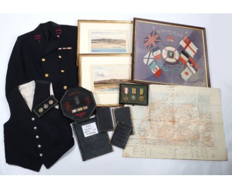
An Important and Well-Documented Medal, Uniform and Paperwork Grouping of Chief Petty Officer W. W. Collins, Royal Naval Volunteer Reserve / Royal Naval Air Service, Who Served as an Observer with No. 1 Kite Balloon Section Aboard the First Kite Balloon Ship, H.M.S. Manica, During the Dardanelles Campaign of 1915, 1914-15 Star “LAA. 1025, W. W. Collins, A.B., R.N.V.R.”; British War and Victory Medals “L.A.A. 1025 W. W. Collins. C.P.O. R.N.V.R.”, mounted in a period frame, together with his Silver War Badge, 'R.N. 7174', the last lacking wearing pin, nearly extremely fine. Accompanying the medals is a glazed frame of headdress badges, RNAS embroidered shoulder title and RNAS embroidered arm eagle. Royal Naval Volunteer Reserve tunic with double row of gilt buttons, to the collar embroidered R.N.V.R A.A.C collar patches and WW1 medal trio ribbons above the breast. Finely executed pair of watercolours of Sulva Bay 1915 signed by Collins to the lower corner; WW1 Commemorative tapestry with flags of the allies; original linen backed map of Gallipoli; archive of diaries and sketchbooks all documenting his time in the service. Chief Petty Officer Collins was responsible for directing the fire of the supporting warships; despite being subject to attack by shore battery and enemy aircraft, Collins, a famous artist, produced an outstanding first-hand written and artistic account of events as they happened. This grouping was originally sold by Spink in 2019, Lot 714. The grouping was consigned to them by direct family descendent and has only been in one hand since then.
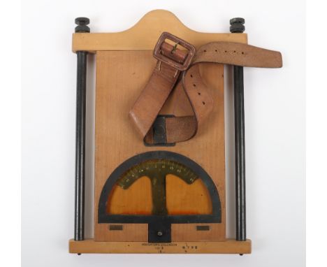
WW1 British Officers Map Board and Map Case Attributed to Captain H J Thomson 2nd Battalion Gordon Highlanders, wooden map board with compass to the top section. Complete with large leather strap fitting, referred to as the Cavalry type. Accompanied by a canvas map case with the underside of the flap being inked with the details “CAPT H. J. THOMSON 2/GORDONS”. (2 items)


WW2 Imperial Japanese Equipment Grouping, consisting of well worn brown leather officers map case with stitched star to the centre flap; Japanese canvas cloth bread bag with shoulder strap and ink stamping to underside of the flap; Japanese water bottle with canvas carry harness and strap; Japanese metal mess tin with remains of the brown paint finish; pair of Japanese cloth tunic putees and a small brown leather Japanese equipment pouch. (6 items)


VARIOUS TYPE COLLECTOR'S CARDS & EPHEMERA GROUP - to include John Player, W D & H O Wills cigarette cards, Book post cards, Plain Spotter silhouette cards, Daily Express wall map of Europe and other collectable items including two white metal cigarette cases, a small quantity of 45rpm records, Olive Wood Book of Pressed Flowers from the Holy Land and other items of interest
Two framed map prints to include: Robert Morden (1650-1703), Worcestershire, hand coloured print, 40 x 37 cm and; Wenceslas Hollar (1607-1677), 'A New Map of the Citties of London Westminster & y Borough of Southwarke', hand coloured print, 57 x 43 cm, with text verso, both framed and glazed (2)


An official copy of Battle Of The Aisne, 13-15th September 1914, Tour Of The Battle Field published by The War Office December 1934, pocket in back of book contains military maps Battle of the Aisne 1914 'Advance of BEF on 12th-13th Sept', 'Situation at Nightfall 14th September', map overlay 'Dispositions of the British and German Artillery 14th September 1914 and one other map in colour (1) (displayed in cabinet upstairs)


A 17th century hand-coloured engraved map “Comitatus Dorcestria Vulgo Anglice DorsetShire” by Jan Janson, 15½” x 20”; an 18thcentury engraved map by Emanuel Bowden “An Improved Map of Wiltshire Divided into its Hundreds…”, 21½” x 28½” (both framed but unglazed); & a later reprinted map of Surrey, 8½” x 10½”.
-
109198 item(s)/page