We found 109198 price guide item(s) matching your search

Refine your search

Year

Filter by Price Range
  • List
  • Grid
  • 109198 item(s)
    /page

Lot 97

Ireland. Camocio (Giovanni Francesco), Irlanda, published by Fernando Bertelli, Venice, circa 1575, uncoloured engraved map oriented to the east, large margins, slight spotting, 135 x 190 mmQTY: (1)NOTE:Andrew & Charlotte Bonar Law. The Printed Maps of Ireland to 1612, page 11.Rare. Camocio is believed to have died in Venice in the early 1570s, probably during an outbreak of the plague. His plates passed to Bertelli who re-issued Camocio's Isole Famosa Porti Fortezzi..., about 1575. The maps are unchanged apart from the addition of a page number to the lower right corner of the map.

Lot 219

* Gillray (James). Phaeton alarm'd! H. Humphrey March 22nd 1808, etching with contemporary hand-colouring, large margins, borders a little toned and dust soiled, some marginal closed tears, later ink marginalia and some ink linear marks affecting the printed image, 340 x 375 mmQTY: (1)NOTE:BM satires 10972.A somewhat sycophantic caricature by Gillray depicts Canning as Phaeton driving a chariot across the sky in a semi-heroic composition. Gillray is gentle with the Foreign Secretary depicting him travelling across a celestial panorama, filled with malevolent opponents. Below the panorama is a map of Europe set ablaze by the Napoleonic wars.

Lot 268

Popery. Popish Cruelty Display'd, Being a short, but impartial history of some of the assassinations, murders, and inhumane slaughters, committed by papists upon protestants ..., [London?], 1718, guarded-in title edge-frayed and with early ink manuscript name Willm Hodgson, bound with: Nottingham (Daniel Finch, Earl of), The Answer of the Earl of Nottingham to Mr. Whiston's Letter to Him, concerning the Eternity of the Son of God, and of the Holy Ghost ..., eighth edition, London: for Edward Valentine, 1721, 3pp. advertisements at end, bound with: [Randolph, Herbert], Some Plain and Short Arguments from Scripture proving the Lord Jesus Christ to be the supreme God ..., sixth edition, London: for John Clark, 1719, bound with: Popping (S., publisher), The Lay-Mens Humble Representation of their Just Grievances, London, 1720, bound with: Calamy (Edmund), A Letter to Mr. Archdeacon Echard, upon occasion of his History of England, third edition, London: for John Clark, 1718, woodcut head- and tail-pieces and initials, generally toned, occasional minor marks or stains, some dust-soiling, hinges cracked, mid-18th century blind-tooled calf, rubbed, one corner showing, minor worming to spine ends, 8vo, together with: [Zacharie de Lisieux, pe?re], A Rela[tion] of [the] Cou[ntry of] Ja[nsenia, Ne[ver Till Now Described, Wherein] is [... composed in French by Lewis Fountaine, Esq; and newly translated into English by P.B.], [1668], majority of title lacking and torn away (with an additional usual version of the title bound-in at the rear), without folding map, some toning, dust- and finger-soiling mainly at front and rear, few leaves lightly edge-frayed or with minor losses to blank margins, without front endpapers, contemporary calf, worn, small 8vo, plus: Gunter (W.), Gunter's Confectioner's Oracle, London: Alfred Miller, 1830, 4 plans (one folding), without portrait frontispiece, lightly toned, scarce minor spotting, hinges cracked, contemporary maroon half calf, worn, front joint cracked and board loose, spine covering defective, 8vo, with 4 other antiquarian titles (one in 2 volumes), some defectiveQTY: (8)NOTE:First item: ESTC T180090, T21975, T49335, T171246 & T38157 respectively.Second item: ESTC R38878; Wing F1410 for the usual edition. This copy appears to have remnants of a rare version of the title with the additional phrase 'Never till now described'. This version is not in ESTC, Wing or Library Hub. We have only found one mention of this version: in the catalogue of the first portion of the ... library of the late James Crossley, sold by auction by Sotheby, Wilkinson & Hodge 21-28 July 1884 (lot 896).

Lot 100

Ireland. Philippe (Pierre), L'Irlande conforme aux Itinéraires et assujettie aux observations astronomiques..., circa 1787, uncoloured engraved map, three lines of scale to the right-hand vertical margin, 270 x 405 mm, together with Van der Aa (Pieter). Lagenie où Leinster, Leiden, circa 1710, hand-coloured engraved map presented in a 'picture frame' border, 235 x 400 mm, with Seale (R. W.). Plans of the Principal Towns, Forts and Harbours in Ireland; For Mr Tindal's Continuation of Mr Rapin's History, circa 1760, sixteen uncoloured engraved plans on one sheet (as published), old folds, 405 x 500 mm, plus Turrel (E.). Dublin [and] the Environs of Dublin, published under the Superintendance (sic) of the Society for the Diffusion of Useful Knowledge, 1833, two engraved city plans, both with contemporary outline colouring, slight mount staining to the plan of Dublin, each approximately 320 x 400 mm, with another copy similar of the plan of Dublin, and Walker (J & C). Ireland, published under the Superintendence of the Society for the Diffusion of Useful Knowledge, circa 1833, engraved map with contemporary outline colouring, 390 x 330 mm, with Chatelain (Henri). Carte du Gouvernement Civil et Militaire avec L'Etat des Officiers du Royaume D'Irlande, circa 1719, two uncoloured engraved maps of Ireland, two heraldic shields and two interior views of the Irish parliament, all set within descriptive French text, 365 x 465 mm QTY: (8)NOTE:Andrew Bonar Law. The Printed Maps of Ireland 1612 - 1850, number 134 ii (Philippe).

Lot 407

Malcolm (John). The Political History of India from 1784 to 1823, 2 volumes, 1st edition, London: John Murray, 1826, errata leaf at end of vol. I, light spotting front and rear, irst volume with ownership signature John Stracey 1827 to pastedown, edges untrimmed, original cloth-backed boards, printed paper title label to spines of each volume, spines and joints worn, 8vo, together with: Barrow (George). Ceylon: Past and Present, London: John Murray, 1857, folding engraved map, 32 pp. publisher's adverts at rear, original cloth gilt, extremities lightly rubbed, 8vo, plus Radclyffe (Charles W.). Memorials of Eton College, 1st edition, Eton: T. Ingalton & Son, 1844, tinted lithograph title and 23 plates, foxing and some damp staining, contemporary red half morocco, gilt decorated spine, some wear and marks, folio, plus Peel (Lawrence). Horæ Nauseæ, London: Printed by Bradbury and Evans, 1841, contemporary manuscript note to verso of front free endpaper; 'Edwards Anson, From the Author, Laurence Peel, Jun 12, 1879(?)', light spotting, publisher's original cloth binding, 4to, plus 14 other volumes and 3 folding maps (Switzerland, India, The North of England and part of Scotland), various sizes and condition QTY: (22)

Lot 5

Bower (Hamilton). Diary of a Journey Across Tibet, 1st edition, London: Rivington, Percival and Co, 1894, ownership inscription of John Bower (the author's brother) to half-title, frontispiece, folding map (frayed with small loss), 29 full-page and smaller illustrations, hinges cracked, sewing loosened with text block separated in places, original green pictorial cloth, rubbed with some wear to extremities, 8voQTY: (1)NOTE:Yakushi B533. In 1891 Hamilton Bower and Dr. W. G. Thorold, at the instigation of the British Indian intelligence service, travelled 1200 miles across the Tibetan plateau through unknown country, at an average elevation of 19000 feet, despite being deserted by their guides, their food supplies giving out and almost all their transport animals dying. The Indian sub-surveyor Atma Ram accompanied Bower and Thorold and made an important map of the region which is reproduced in the book. Bower was the first European to cross the Tibetan plateau, for which he was awarded the Founder's Medal of the Royal Geographical Society.

Lot 373

Childers (Erskine). The Riddle of the Sands, 1st edition, London: Smith, Elder, & Co, 1903, folding map frontispiece, 3 maps (two loose), 4 pp. publisher's advertisements at rear, rear hinge tender, original pictorial cloth, some wear to extremities, backstrip reinforced, 8voQTY: (1)

Lot 121

Wales. Speed (John), Cardigan Shyre Described with the due forme of the Shire town as it was surveyed by J. S. in 1610, Thomas Bassett & Richard Chiswell [1676], engraved map with sparse outline colouring, inset town plan of Cardigan, large strapwork cartouche and compass rose, some marginal fraying and chipping but not affecting the printed image, 380 x 510 mm, English text on verso, together with Speed (John). Caermarden Both Shyre and Towne Described, John Sudbury and George Humble, circa 1627, uncoloured engraved map, inset town plan of Carmarthen, large strapwork cartouche and compass rose, toned overall, 385 x 510 mm, no text on verso, with Blaeu (Johannes). Glamorganensis Comitatus vulgo Glamorgan Shire, Amsterdam, circa 1648, engraved map with contemporary outline colouring, some creasing to the central fold, slight staining, large margins, 380 x 505 mm, French text on verso, with another three Welsh county and regional maps including examples by or after Moll, Mercator and Speed, various sizes and conditionQTY: (6)

Lot 418

Du Chaillu (Paul B.). Explorations and Adventures in Equatorial Africa;..., 1st edition, New York: Harper & Brothers, 1861, numerous monochrome illustrations, folding map to the rear, some light spotting & marginal toning, original embossed brown cloth, boards & spine rubbed & slightly water marked, 8vo, together with:Brown (J. Tom), Among the Bantu Nomads, 1st edition, London: Seeley, Service & Co., 1926, 17 monochrome illustrations, some light marginal toning, original cloth in dust jacket, covers rubbed with some loss, 8vo, plusWeeks (John H.), Congo Life and Folklore, London: The Religious Tract Society, 1911, monochrome illustrations, frontispiece detached, some spotting &light toning, original decorated green cloth, spine lightly rubbed to head & foot, 8vo, and other late 19th & early 20th century Africa reference & related, including The Colonial Office List, 3 volumes 1908, 1912, 1933, London: Waterlow & Sons, original red cloth, 8vo, & 7 folding maps, mostly original cloth, some paperback editions, some odd volumes, G, 8voQTY: (3 shelves)

Lot 45

Park (John James). The Topography and Natural History of Hampstead, in the County of Middlesex, 1st edition, London: White, Cochrane, and Co, 1814, engraved frontispiece, folding map, 9 engraved plates (one loose), lightly spotted, contemporary calf rebacked to style, green morocco title label lettered in gilt, blindstamped armorial of William Bagot, 2nd Baron Bagot to covers, some light wear, 8voQTY: (1)NOTE:Provenance: William Bagot, 2nd Baron Bagot, included in list of subscribers.

Lot 237

Bible [English]. The Holy Bible, conteining the Old Testament and the New. Newly Translated out of the Originall Tongues: and with the former Translations diligently compared and revised, by his Maiesties special commandement. Appointed to be read in Churches, Imprinted at London by Robert Barker, 1613, general title within decorative woodcut border with genealogical entry to verso 'John Willis being born in the year 1705. Ye daughter of John Willies was borne febry. ye 5 1719/20' (short closed tear at head), New Testament title within decorative woodcut border with imprint dated 1612 (with small torn area towards gutter and slight border loss, manuscript alphabet, numbers and marks to verso), Apocrypha present, A4 of Translations to the Reader torn with text loss to lower outer quarter of leaf, D43 with upper outer corner torn away, closed tear to 2G1 and 2G2 at head, 2K4 with early manuscript inscriptions to verso and bearing the names Robert Hickson[?], John Douthwaite and George Harrison, 2P3 torn to lower outer corner with test loss, 2T2 closed tears at foot, 2V6 torn at foot with slight text loss, 3D3 torn to lower outer corner with loss, 3K7 with repaired long closed tear, 3T5 and 3T6 with small torn area and loss towards gutter, 3Z5 torn at foot with text loss, [A3] torn to upper outer corner with loss, [L7] with old paper repair at foot, manuscript inscriptions and notes to verso of final leaf of text, colophon dated 1612, few other short closed tears (few repaired), bound with at front The Genealogies recorded in the Sacred Scriptures..., by J[ohn]. S[peed]., [1613?], woodcut genealogies and double-page woodcut map of Canaan (with short closed tear to fore-edge), long closed tear to C4 and leaves D1, D3 and D4 torn with loss, also bound at front with an incomplete Book of Common Prayer (lacking all before B3), bound with at rear an incomplete The Booke of Psalmes..., London: Companie of Stationers, 1612, toning and dust-soiling throughout, spotting and few marks, early 19th-century panelled sheep, upper board detached, torn at head and foot of spine, wear to extremities, 4to (20.5 x 15.5 cm)QTY: (1)NOTE:Darlow and Moule 247; Herbert 320; STC 22255.Closely resembles the first quarto of 1612 (Herbert 313). Ruth iii, 15, she. Gen. i. 11, bring foorth. Herbert states both titles omit the words Appointed ..., however, the word is included in the general title of this example.

Lot 78

British Isles. A collection of 8 maps, mostly 18th & 19th-century, engraved maps, including examples by or after De Rossi, Tirion, Von Reilly, Waesbergen/Cloppenburg, Sayer, Ainslie and Bonne/Lattre, the John Ainslie map sectionalised and laid on linen, the first map by De Rossi is uncoloured, the remainder with contemporary colouring, various sizes and condition,QTY: (8)

Lot 109

London. Greenwood (C & J), Map of London from an actual survey made in the years 1824, 1825 & 1826..., Greenwood & Co, 1st edition, August 21st, 1827, large scale map engraved by James & Josiah Neele with contemporary colouring, sectionalised and laid on linen, calligraphic title, inset views of St Pauls and Westminster, dedication to King George IV, reference to the parishes and table of explanation, some offsetting, edged in green silk with slight fraying, 1260 x 1855 mm, bookplate of L. C. Berger to verso, contained within contemporary tree calf book box (rubbed and slightly worn) QTY: (1)NOTE:Howgego 309. The largest and finest map of London to be printed in the 19th century. The Greenwood brothers spent three years preparing this remarkable new survey, illustrating for the first time the planned development of Belgravia by Thomas Cubitt, the completion of the Grand Surrey Canal and Regent's Park one year before it was finished in 1828. No map provided greater detail or accuracy until the Ordnance Survey.

Lot 79

British Isles. Elwe (Ian), Les Isles Britannique qui contiennent les Royaumes d'Angleterre, Ecosse et Irlande..., Amsterdam, 1792, engraved map with contemporary wash colouring, inset map of the Shetland and Orkney Islands, slight overall dust soiling, very slight creasing, 475 x 595 mm, together with Jaillot (Hubert). Les Isles Britanniques qui contiennent les Royaumes d' Angleterre, Escosse et Irlande..., circa 1709, engraved map with contemporary outline colouring, inset map of the Shetland, Orkney and the Faroe Islands, decorative cartouche and mileage scale, 465 x 655 mm, with Faden (W.). A Map of England, Wales & Scotland describing all the Direct and Principal Cross Roads in Great Britain..., Aug. 12th 1800, engraved map with bright contemporary wash colouring, inset map of Scotland, very slight staining, 735 x 606 mm, plus Mercator (Gerard). Eboracum, Lincolnia, Derbia, Staffordia, Notinghamia, Lecestria, Rutlandia et Nofolcia, circa 1600, engraved map of north-east England with contemporary outline colouring, large strapwork cartouche, 360 x 420 mm, French text on verso, and another eight maps of England & Wales, including examples by or after Wilkinson, Bradshaw, Le Rouge and Stieler, various sizes and condition QTY: (12)

Lot 251

Hammond (Henry). A Paraphrase, and Annotations upon all the Books of the New Testament: Briefly explaining all the difficult places thereof, London: Printed by J. Flesher for Richard Royston, 1653, title with etched illustration, also with 18th-century ownership inscription 'Samuel Taylor M.A. Vicr. of Quinton in Gloucestershire: and late Rector of Saint Clement in Worcester, 1738', advert leaf present at rear, light worming to upper and lower margins of initial few leaves and damp-stain at head of last few leaves, front endpapers with 18th and 19th-century ownership inscriptions of Robert Etherington and Samuel Taylor Etherington of Tutbury and Sudbury, contemporary calf, torn at head with loss, leather to boards also torn with some loss, worn, folio, together with:Book of Common Prayer, and Administration of the Sacraments, and other Rites and Ceremonies of the Church..., together with the Psalter or Psalms of David..., London: Printed by Charles Bill, and the Executrix of Thomas Newcomb, deceas'd, 1706, engraved frontispiece, title in red and black, margins ruled in red throughout, sewing weak at front of volume and some leaves loose/detached and frayed at edges, all edges gilt, contemporary gilt panelled and decorated red morocco, folio, plus two others Burkitt (William). Expository Notes, with Practical Observations, on the New Testament..., 13th edition, carefully corrected, London: R. Ware, J. and P. Knapton, S. Birt [et al.], 1752, engraved portrait frontispiece, title in red and black, numerous engraved plates (one folding) and folding engraved map at rear, contemporary calf, morocco title label to spine, joints cracked, extremities worn, folio, and Hooker (Richard). Of the Lawes of Ecclesiastical Politie, London: Andrew Crooke, 1666, engraved portrait frontispiece and engraved title, frontispiece detached and initial leaves frayed, damp staining and mottling throughout volume to lower margins with consequent damp-fraying particularly to lower inner corners, contemporary calf, spine torn with loss, worn, folioQTY: (4)

Lot 311

Hobbes (Thomas, translator). The History of the Grecian War: in Eight Books, written by Thucydides, 2nd edition, corrected and amended, 1676, engraved additional title, letterpress title printed in red and black, 3 folding and double-page engraved maps, 2 engraved plates, frontispiece and front endpapers detached (folding map a little frayed at margins, small light water stain), rear blank with 18th century annotations, previous owner signatures of Frances Shirley and J. B. Locke to letterpress title, bookplate of Robert Quirk (with manuscript date of 1903), contemporary calf, upper cover detached, rebacked with original spine relaid, label renewed, some edge wear, folio QTY: (1)NOTE:Provenance: Frances Shirley (Lady Frances Shirley, 1707-1778), signature to title.Wing T1134. First published in 1629, this is Thomas Hobbes' most famous translation and the first directly from the Greek. He also drew the ancient map of Greece.

Lot 82

Buckinghamshire. Speed (John), Buckingham Both Shyre and Shire Towne describ., published Thomas Bassett and Richard Chiswell, circa 1676, uncoloured engraved map, inset town plans of Reading and Buckingham, large margins, slight overall toning, 385 x 510 mm, English text on verso, together with Morden (Robert). Buckinghamshire [1695 or later], uncoloured engraved map, 420 x 350 mm, with Buckinghamshire, circa 1702, uncoloured engraved map, old folds, 255 x 155 mmQTY: (3)

Lot 98

Ireland. Jefferys (Thomas), A New and Accurate Map of the Kingdon of Ireland divided into Provinces, Counties and Baronies; with all the Cities, Boroughs, Post Towns, Barracks and Principal Villages..., printed for John Bowles, Robert Sayer, Thos. Jefferys and Carington Bowles [1759 - 75], engraved map with contemporary outline colouring, sectionalised and laid on linen, slight dust soiling, 650 x 605 mm, together with Carington Bowles (publisher). Bowles's New Pocket Map of the Kingdom of Ireland, Divided into its Provinces, Counties and Baronies..., 24th June 1779, engraved map with contemporary outline colouring, sectionalised and laid on linen, slight dust soiling and staining, 625 x 590 mm QTY: (2)NOTE:Andrew Bonar Law, The Printed Maps of Ireland, number 91 state 4 (Jeffreys) and 120 state 2 (Bowles).

Lot 95

Folding Maps. A collection of 23 maps, 18th & 19th century, 23 engraved and lithographic map sheets of British county and regional maps and foreign maps and plans, all sectionalised and laid on linen, including examples by or after Walker, Philips, Wyld (including a four sheet map of Europe), Bowen, J & C Walker, 'The Times', Ordnance Survey, Hebner, Ebden, Assheton, Brué (map of France on four sheets) and Darton & Dix (county maps of Essex and Bedfordshire), various sizes and conditionQTY: (23)

Lot 107

Liverpool. Gage (Michael Alexander), This Trigonometrical Plan of the Town and Port of Liverpool including the environs of Kirkdale Everton Lowhill Edge Hill & Toxteth from actual survey..., March 1st 1836, engraved map with contemporary outline colouring, sectionalised and laid on linen, calligraphic title, table of reference and additional information including tides, boundaries and history, dedication to William IV and compass rose, slight staining and offsetting, slight dust soiling to the margins, blind stamped cloth endpapers, 1050 x 1660 mm, contained within a contemporary cloth slipcase with a morocco gilt label to the upper cover, slipcase heavily worn and frayedQTY: (1)

Lot 8

Cheesman (Robert Ernest). In Unknown Arabia, with a Foreword by Major-General Sir Percy Z. Cox, 1st edition, London: Macmillan and Co., Limited, 1926, photographic frontispiece and plates, half-title (lightly toned), folding map, short closed tear to hinge of folding map, original dark green cloth gilt, spine slightly faded, slight rubbing with some loss of colour to head and foot of spine, 8vo,QTY: (1)

Lot 28

Barrett (William). The History and Antiquities of the City of Bristol ..., Bristol: William Pine, [1789], folding engraved map, slightly edge-frayed, with closed handling tear and short split to inner fold, title with engraved printer's device, small hole to blank gutter, 29 engraved plates (correct as list, 14 folding), including Facsimile of Rowley's Manuscript, plates spotted and offset, extra-illustrated with two folding maps: Plan of the City and Suburbs of Bristol including Clifton & the Hotwells, Bristol: R.Edwards, November 1st 1799, and a facsimile of the 1671 map by I.M.: An Exact Delineation of the Famous Cittie of Bristoll and suburbs thereof, both folding and with a single short split to fold or closed edge tear, the former slightly edge-frayed, contemporary mottled calf gilt, rebacked, rubbed, minor wear to extremities, 4to, together with: Balch (Herbert E.), Wookey Hole, its Caves and Cave Dwellers, London [etc]: Humphrey Milford Oxford University Press, 1914, photogravure frontispiece, black & white illustrations, photogravures, and plans (some with hand-colouring), original linen-backed boards, some wear to corners, few minor marks, 4to, plus: Hamerton (Philip Gilbert), The Unknown River, London: Seeley, Jackson, and Halliday, 1871, mounted etched plates and title vignette, advertisement leaf at rear, binder's ticket of Hanbury & Simpson, Fleet St, all edges gilt, original blue cloth gilt, extremities rubbed, some stains and marks (mainly to rear cover), 4to, with 4 other titles, including: Bibliotheca Somersetensis, by Emanuel Green, 3 volumes, 1902, (ex. Brighton Public Library); Topographical Dictionary of Scotland, by S. Lewis, 2 volumes, 1846; Old English Household Life, by G. Jekyll, 1925; and West Country Churches, by W.J. Robinson, volume 3 only, 1915QTY: (10)

Lot 16

Middleton (Charles Theodore). A New and Complete System of Geography. Containing a full, accurate, authentic and interesting account and description of Europe, Asia, Africa, and America ..., 2 volumes, London: for J. Cooke, [1777-1778], vol.II title printed in red & black, 20 uncoloured engraved maps (including 7 folding), and 100 engraved plates, 4 maps with some edge fraying and chipping, one unfolded map (Scotland) with 3.5 cm closed edge tear, one folded map (North America) with central fold mostly split (with associated shorter tears and fraying), each front pastedown with early ink manuscript presentation label, inscribed in a calligraphic hand: Henry Budd, Southampton, to Henry Budd Blackmore of Hinton Ampner, both front hinges cracked, contemporary sprinkled calf, red morocco label to each spine, worn, 3 hinges cracked, vol. I rear cover detached, folioQTY: (2)

Lot 123

* Worcestershire. Saxton (Christopher & Lea Philip), Worcestershire and Citty exactly described by C. S. newly augmented by Phil. Lea [1689 - 94], hand-coloured engraved map, inset city plan of Worcester, strapwork cartouche and mileage scale, 375 x 500 mm, mounted, framed and glazedQTY: (1)

Lot 47

Perry (Capt. John). An Account of the Stopping of Daggenham Breach: with the Accidents that have attended the same from the first undertaking. Containing also proper rules for performing any the like work: and proposals for rendering the Ports of Dover and Dublin ... commodious for entertaining large ships. To which is prefix'd, a plan of the Levels which were overflow'd by the Breach, 1st edition, London: Benj. Tooke, 1721, title with early initial stamp R. L. at head and errata slip pasted to verso, folding engraved map by H.Moll, contemporary calf, joints slightly cracked, 8voQTY: (1)NOTE:An account of the engineering work undertaken by the hydraulic engineer John Perry in repairing two breaches in the Thames embankment at Dagenham, caused by storms and neglect.

Lot 49

Rudder (Samuel). A New History of Gloucestershire, comprising the topography, antiquities, curiosities, produce, trade, and manufactures of that county, 1st edition, Cirencester: Samuel Rudder, 1779, folding engraved county map, 14 engraved plates and two single-page plans, armorial bookplate of Thomas Wakeman to front pastedown, contemporary diced calf gilt, rebacked with original spine relaid, folio, together with:Bigland (Ralph). Historical, Monumental and Genealogical Collections, Relative to the County of Gloucester, 2 volumes in 1, 1st edition, London: John Nichols, 1791-92, volume 1 with 22 engraved plates, engraved armorial to dedication leaf, volume 2 with 10 (of 11) engraved plates, lacking pp.69-72 and pp.225-252, preliminary leaves frayed and wormed, a few large closed tears, endpapers renewed, ownership inscription of William Capel, The Grove to front pastedown, untrimmed, contemporary quarter vellum, manuscript titles, scuffed and frayed with loss, folio, plusRudder (Samuel). A New History of Gloucestershire, comprising the topography, antiquities, curiosities, produce, trade, and manufactures of that county, 1st edition, Cirencester: Samuel Rudder, 1779, folding engraved map frontipiece (slightly browned and torn, with repairs on verso), 4 (of 17 plates), ownership inscription to title 'John Small Junr His Booke Octr 5: 1779', hinges strengthened with fabric tape, contemporary mottled calf gilt, rebacked, extremities. rubbed and head of spine slightly frayed, folioQTY: (3)

Lot 465

Ticehurst (Claud B.). A History of the Birds of Suffolk, 1st edition, London: Gurney and Jackson, 1932, monochrome illustrations, some light marginal toning, original green cloth, spine lightly faded & rubbed to head & foot, 8vo, together with:Bucknill (John A.), The Birds of Surrey, 1st edition, London: R. H. Porter, 1900, monochrome illustrations & map, front & rear gutters cracked, some light spotting & toning throughout, original red cloth, boards & spine slightly rubbed to head & foot, 8vo, plusAplin (O. V.), The Birds of Oxfordshire, 1st edition, Oxford: Clarendon Press, 1889, hand coloured frontispiece, monochrome map, some minor marginal toning, original blue cloth, spine lightly faded, boards & spine very lightly rubbed to head & foot, 8vo, and other late 19th century & modern ornithology reference, including The Birds of The British Isles, 12 volumes, by David A. Bannerman & George E. Lodge, circa 1950s-60s, all original cloth in dust jackets, large 8vo, some paperback editions, mostly original cloth, some in dust jackets, G/VG, 8voQTY: (6 shelves)

Lot 1

Baedeker (Karl). Egypt, Handbook for Travellers edited by K. Baedker, Part Second: Upper Egypt with Nubia as far as the Second Cataract and the Western Oases, Leipzig & London: Karl Baedeker, 1892, & Palestine and Syria with the chief routes through Mesopotamia and Babylonia, 4th edition, Leipzig and London, Karl Baedeker, 1906, colour maps and plans etc., including some folding, both original red cloth gilt, first volume a little rubbed and lightly soiled, 8vo, together withNordhoff (Charles). California: For Health, Pleasure, and Residence, a book for travellers and settlers, 1st edition, New York: Harper & Brothers, 1874, single-page map frontispiece, wood-engraved illustrations, original green cloth gilt, a little rubbed, large 8vo, plusFergusson (James). History of Indian and Eastern Architecture, 2 volumes, 1st edition, London: John Murray, 1910, numerous monochrome illustrations, top edge gilt, modern maroon cloth gilt, thick 8vo, and other various travel interest including Baedeker Guides (Japan, 8th edition, 1907, another copy of Palestine and Syria, 4th edition, 1906, Greece, 4th edition, 1909, and Northern Italy, 1886), Cook's Traveller's Handbook for Palestine and Syria by Roy Elston, 1929, C. C. Ghosh, The Silk Industry of Japan with notes on observations in the United States of America, England, France, and Italy, Delhi: 1933, etc.QTY: (17)

Lot 116

Surrey. Bryant (Andrew), Map of the County of Surrey from actual survey by A. Bryant in the years 1822 and 1823..., June 1st 1823, large scale engraved map with contemporary colouring, sectionalised and laid on linen, calligraphic title and compass rose, list of ecclesiastical divisions and table of explanation, some offsetting, edged in green silk with slight fraying, green endpapers, 1510 x 1955 mm, contained within contemporary book box (very rubbed and worn with loss)QTY: (1)

Lot 75

Braun (Georg & Hogenberg Franz). Oxonium nobile Anglie oppidum Septenrionalem..., circa 1575, an engraved panorama of Oxford with contemporary hand-colouring, thread margins along the horizontal borders, slight toning to the central fold, 180 x 485 mm, together with Saxton (Christopher & Hole G.). Buckingham comitatus in quo olim Insederunt Cattieuchlani [1610], uncoloured engraved map, large strapwork cartouche and mileage scale, 275 x 290 mm, with Kitchin (Thomas). Hampshire Drawn from the best Surveys & Maps..., circa 1786, hand-coloured engraved map, 175 x 220 mm, supplied with a page of descriptive text, plus Royce (John). A Plan of the Canals now making from the several Coal Mines in the neighbourhood of Stourbridge and Dudley to the Great Canal from the Trent to the Severn near Stourton in the County of Stafford, Survey'd in 1775 by Robert Whitworth, circa 1776, uncoloured engraved canal map, old folds, repaired tear to the right - hand vertical margin, but not affecting the printed image, 175 x 370 mmQTY: (4)

Lot 81

British Isles. Quad (Matthias), Angliae regni florentisimi nova descriptio auctore Humeredo Lhuyd Denbygiense, Cologne [1592 - 1608], uncoloured engraved map, slight dust soiling and text show through, large margins, 185 x 265 mm, Latin text on verso, together with Jansson (Jan, Mercator Gerard & Hondius H.). Anglia, circa 1634, hand-coloured engraved map, originally published in the 'Atlas Minor', 150 x 200 mm, Latin text on verso, framed and double-glazed QTY: (2)NOTE:R. W. Shirley, Early Printed Maps of the British Isles 1477 - 1650, 172 (Quad), and 402 (Jansson).

Lot 119

The Americas. Zatta (Antonio), L'America divisa ne' Suoi Principali Stati, Venice, 1770, engraved map with contemporary outline colouring, large margins, 315 x 405 mm, QTY: (1)

Lot 108

London. Cruchley (G. F.). Cruchley's New Plan of London Improved to 1827. Including the East and West India Docks, 1827, engraved map with contemporary outline colouring, sectionalised and laid on linen, slight staining, some dust soiling, 460 x 935 mm, marbled endpapers, contained in a contemporary green marbled slipcase with publisher's yellow printed label to the upper cover, some wear and ink staining, together with Bowles & Carver (publisher). Bowles's Reduced New Pocket Plan of the Cities of London and Westminster with the Borough of Southwark exhibiting the New Buildings to 1799, engraved map with contemporary outline colouring, sectionalised and laid on linen, several splits along old linen folds, some dust staining and creasing, 390 x 555 mm, contained in a contemporary marbled card slipcase with publisher's printed labels to both covers, some wear to the extremities, with Andrews (J.). Andrews's New and Accurate Map of the Country Thirty Miles Round London..., 4th edition, James Heskett, August 1st 1820, engraved map with contemporary outline colouring, sectionalised and laid on linen, very slight staining, 685 x 635 mm, lacking slipcase, plus Froggett (John Walter). Froggett's Survey of the Country Thirty Miles Round London, May 1st 1832, engraved map with contemporary outline colouring, sectionalised and laid on linen, very slight staining, 1090 x 1365 mm, later biro annotations to the endpapers, contained in a modern green cloth slipcase and Cruchley (G. F.). Cruchley's Twelve Miles Round London, 1826, engraved circular map with contemporary outline colouring, sectionalised and laid on linen, some offsetting, 380 x 380 mm, marbled endpapers, contained in a contemporary green marbled slipcase with publisher's yellow printed label to the upper cover, some wear, and another seven folding maps of London, including examples by or after Cary, Bacon, W. H. Smith and Bartholomew, various sizes and condition QTY: (12)NOTE:James Howgego. Printed Maps of London, numbers 304 (2nd edition, state B), 158a (state 11), 172 (state 5), 333 (state 1a) and not listed.

Lot 32

Butcher (Edmund). Sidmouth Scenery; or, Views of the Principal Cottages and Residences of the Nobility and Gentry: with a description of that admired Watering-Place, and the environs, within fifteen miles round, 1st edition, 1st issue, Sidmouth: John Wallis, circa 1819, folding hand-coloured aquatint frontispiece view of Sidmouth, additional hand-coloured aquatint title with view of Knole Cottage, 20 hand-coloured aquatint plates by H. Haseler, additional leaf at rear with engraved map to text of Sidmouth, list of subscribers, lightly spotted, contemporary mottled calf gilt, rubbed, 8voQTY: (1)NOTE:Abbey Scenery 307.There were two issues of this book of views, the first, as here, with a total of 22 plates (including frontispiece & additional title), and the second with a total of 24 plates (including frontispiece & additional title).

Lot 14

Livingstone (David). A Narrative of Dr. Livingston's Discoveries in South-Central Africa, from 1849 to 1856, 1st edition thus, London: Routledge and Co., 1857, folding map frontispiece, spotting to fore-edge, original pictorial paper-covered boards, rebacked (with endpapers renewed), rubbed, 8voQTY: (1)NOTE:The first appearance in book form of Livingstone's travels in Africa (the preface dated January, 1857). The same author's Missionary Travels and Researches in South Africa did not appear until November of the same year. 'In giving to the world the first authentic narrative of the important explorations of the Rev. Dr. Livingstone, the publishers have to acknowledge their obligations to the spirited conductors of the British Banner, in whose columns, in detached portions, this remarkable history first appeared' (Preface).

Lot 93

Essex. Greenwood (C & J), Map of the County of Essex, from an actual survey made in the year 1824..., Greenwood, Pringle & Co. July 1st 1825, large scale uncoloured engraved map, sectionalised and laid on linen, calligraphic cartouche, table of explanation, compass rose and a vignette view of Audley End House, edged in green silk with some fraying, some offsetting and spotting, 1330 x 1570 mm, contained in a later slipcase (rubbed) QTY: (1)

Lot 39

Graham (Robert. C.). The Carved Stones of Islay, Glasgow: James Maclehose and Sons, 1895, half-title, additional etched decorative title on cream Japon vellum, ink inscription to verso of half-title 'This is one of the copies with plates on Japanese of which only sixty five(?) copies are for sale' indistinctly signed (possibly by publisher), map, 32 photogravures and other illustrations, some scattered spotting, top edge gilt, remainder untrimmed, original quarter morocco gilt, upper board corners rubbed with small loss, gilt title to spine, a little rubbed and minor wear at head of spine, 4to, together withRamsay (Lucy). The Stent Book and Acts of the Balliary of Islay, 1718-1843, privately printed, 1890, half-title, title-page with engraving of map of Islay, plate of signatures, blue endpapers, original half morocco gilt, some marks and rubbing to extremities, gilt title to spine, 4to, limited to 250 copies, plus four other topography books comprising: The Resources, Products and Industrial History of Birmingham...edited by Samuel Timmins, 1866; A Topographical Description of Cumberland, Westmoreland, Lancashire and a part of The West Riding of Yorkshire...by John Housman, 1800, A Complete Guide to the English Lakes by Harriet Martineau, [1855], and A Complete Guide to the English Lakes...by Rev. Professor Sedgwick, 1859, all 8voQTY: (6)

Lot 94

Exeter. Braun (Georg & Hogenberg Frans), Civitas Exoniae (vulgo Excester) Urbs Primaria in Comitatu Devoniae, circa 1617, hand-coloured engraved city plan, repaired closed tear, slight text show through, large margins, 315 x 400 mm, Latin text on verso, together with Meisner (Daniel). Immoderatus Amorinteritum Causat, circa 1638, uncoloured engraved city plan, printers fold and some marginal spotting, 100 x 145 mm, with Hermannides (Rutger). Exonia Excester, circa 1661, uncoloured engraved map, old folds, old tape hinges in the upper margin, 110 x 130 mm, plus Rapkin (J.). Exeter, circa 1860, uncoloured engraved decorative city plan, 260 x 340 mm, and Roper (J.). Exeter, 1805, uncoloured engraved city plan, vignette of Exeter Cathedral, 240 x 180 mm, with Mutlow (J.). Civitas Exoniae (vulgo Excester) Urbs primaria in Comitatu Deconiae, circa 1820, uncoloured engraved plan, reduced from Braun and Hogenberg's earlier engraving, slight staining, short marginal closed tear, 220 x 275 mm, with one other similar QTY: (7)

Lot 88

* Derbyshire. Speed (John), Anno Darbieshire described, Thomas Bassett & Richard Chiswell [1676], hand-coloured engraved map, inset town plan of Derby and a vignette of St. Anne's Well at Buxton, large strapwork cartouche and compass rose, large margins, 385 x 510 mm, mounted, framed and double-glazed, English text on verso, together with Blaeu (Johannes). Darbiensis Comitatus Vernacule Darbie Shire, Amsterdam circa 1646, engraved map with contemporary outline colouring, large allegorical cartouche and mileage scale, 385 x 505 mm, German text on versoQTY: (2)

Lot 70

Barbados. Bellin (Jacques Nicolas), Carte de L'Isle de la Barbade Dressee au Depost des Cartes et Plans de la Marine..., Paris 1758, uncoloured engraved chart, ornate cartouche, numerous rhumb lines, stamp of the 'Depot de la Marine', one repaired closed tear, 590 x 420 mm, together with Homann (J. B.). Insula Barbadoes in suas Parochias distincta..., Nuremberg, circa 1737, engraved map with contemporary wash colouring, trimmed to the neatline and laid on near-contemporary paper, with Rossi (V.). Carta esatta rappresentante l'Isola di Barbados, published M. Coltellini, circa 1763, uncoloured engraved map, slight spotting, 230 x 190 mm, mounted, plus Moll (Herman). A New Map of the Island of Barbados..., circa 1708, uncoloured engraved map, old folds, toned overall, 180 x 260 mm, and Edwards (Bryan). Map of the Island of Barbadoes for the History of the West Indies..., John Stockdale, Oct. 6th 1791, uncoloured engraved map, very slight spotting, 240 x 190 mm, with Bellin (N.). Carte de L'Isle de La Barbade, circa 1780, engraved map with contemporary wash colouring, 215 x 165 mm, mounted, plus Lucas (Fielding, publisher). Barbadoes, published Baltimore, circa 1823, engraved map with contemporary wash colouring, slight spotting and toning, 310 x 250 mm, mounted, framed and glazedQTY: (7)

Lot 424

Anderson (Aeneas). A Narrative of the British Embassy to China in the years 1792, 1793, and 1794;..., 1st edition, London: printed for J. Debrett, 1795, period inscription to the front endpaper, gutters cracked, front endpaper partially detached, some light spotting & toning, contemporary blue paper boards, front board partially detached, loss to the foot of the spine, boards & spine rubbed & marked, large 8vo, together with:Ward (Roland), Records of Big Game and Measurements of Horns, 3 volumes (2nd edition, 1896, 6th edition, 1910, 10th edition, 1935), London: Rowland Ward and Co., numerous monochrome illustrations, previous owner inscriptions to the front endpapers of the 2nd & 10th editions, some minor toning, 2nd edition rebound retaining original cloth spines & boards, 6th & 10th editions in original cloth, boards & spines lightly rubbed & marked, 8vo, plusSturt (Charles), Two Expeditions into the interior of Southern Australia, during the years 1828, 1829, 1830, and 1831:..., volume 1 only, 1st edition, London: Smith, Elder and Co., 1833, folding map, 2 hand-coloured plates & 3 further monochrome plates, bookplate to the front pastedown, some toning & light spotting throughout, contemporary gilt decorated half calf, spine slightly faded, boards & spine slightly rubbed to head & foot, 8vo, and other 19th & early 20th-century travel & sporting reference & related, mostly original cloth, some leather bindings, G/VG, 8vo/folioQTY: (6 shelves)

Lot 50

Rudder (Samuel). A New History of Gloucestershire, comprising the topography, antiquities, curiosities, produce, trade, and manufactures of that county, 1st edition, Cirencester: Samuel Rudder, 1779, folding engraved county map, 14 engraved plates and two single-page plans, lightly spotted, contemporary sprinkled calf, red morocco title label, rebacked with original spine relaid, corners refurbished, rubbed, folio, together with:Bigland (Ralph). Historical, Monumental and Genealogical Collections, relative to the County of Gloucester, 2 volumes in 1, 1st edition, London: John Nichols, 1791, engraved vignette titles, 34 engraved plates, late 19th-century ownership inscription to front free endpaper verso, lightly spotted, contemporary diced calf, rebacked (with endpapers renewed), lightly rubbed, folio QTY: (2)

Lot 288

Gleig (George Robert). The Life of Major-General Sir Thomas Munro, Bart. and K. C. B. Late Governor of Madras..., 3 volumes, 1st edition, London: Henry Colburn and Richard Bentley, 1830, engraved portrait frontispiece to volume 1, folding map frontispiece (with outline colour) of India, 1829 to volume 2, errata slip for volume 2 bound after contents in volume 1, armorial bookplate of Alexander Speirs Esqr., Elderslie to front pastedown of each volume, 'N.F' initials to title pages of vol 2 & 3, contemporary tan calf, gilt detail to spine, lacking the majority of title labels, some spotting to covers, 8vo, together with; Penn (Granville). Memorials of the Professional Life and Times of Sir William Penn, Knt. Admiral and General of the leed during the Interregnum; Admiral, and Commissioner of the Admiralty and Navy, after the Restoration, from 1644 to 1670, 2 volumes 1st edition, London: James Duncan, 1833, engraved portrait frontispiece (some water staining) to each volume plus 2 engravings, facsimile letters and folding tables, excised review of the work loosely inserted (dated in pencil 1833), armorial bookplate of Charles Viscount Halifax to front pastedown to each volume, armorial bookplate of R. E. W. Maddison to front free endpaper, contemporary calf, gilt decorated spines, labels lacking, joints cracking, 8vo, plus, Beckford (William). Recollections of an Excursion to the Monasteries of Alcobaça and Batalha by the Author of "Vathek", London: Richard Bentley, 1835, engraved portrait frontispiece, light spotting and a few repaired tears, burgundy morocco gilt bookplate of W. A. Foyle, Beeleigh Abbey to front free endpaper, bookplate of Mary Hunter to front pastedown, top edge gilt, 20th-century dark brown morocco by Cedric Chivers, Bath, gilt-decorated spine, gilt turn-ins, 8vo, and 8 other volumes, most in leather bindings of red, pink and brown with gilt spines QTY: (14)NOTE:Provenance: Alexander Speirs Esqr., Elderslie (bookplate) for Gleig.Charles Viscount Halifax (bookplate) and R. E. W. Maddison (bookplate) for Penn. W. A. Foyle, Beeleigh Abbey (bookplate) and Mary Hunter (bookplate) for Beckford.

Lot 85

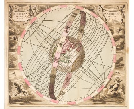
Celestial charts. A collection of eighteen engraved charts, Nuremberg, early to mid 18th century, engraved celestial charts by or after Doppelmayr, Homann, Seutter and Schenk & Valk, all with contemporary hand-colouring, several charts, torn, frayed and dust-soiled, a few with loss1.Tabula Selenographica in qua Lunarium Macularum exacta Descriptio..., J. G. Doppelmayr & J. B. Homann, engraved double-hemisphere of the moon, contemporary hand-colouring, water-stained, torn and frayed with loss to the printed surface, 485 x 585 mm2. Hemisphaerium Coeli Boreale..., J. B. Homann, engraved hemispheral celestial chart, contemporary hand-colouring, water-stained, dust-soiled, margins frayed with slight loss, 490 x 585 mm3. Ephemerides Motuum Coelestium Geometricae, J. B. Homann, engraved hemispheral celestial chart, contemporary hand-colouring, water-stained, dust-soiled, margins and corners frayed with slight loss, 490 x 580 mm4. Phaenomena Motuum Irregularium quos Planetae inferiores Venus et Mercurius ad annum Salutis MDCCX..., J. G. Doppelmayr & J. B. Homann, engraved hemispheral celestial chart, contemporary hand-colouring, water-stained, dust-soiled, margins and corners frayed with slight loss, trimmed to the neatline along the lower horizontal margin, 490 x 575 mm5. Hemisphaerium Coeli Australe..., J. G. Doppelmayr & J. B. Homann, engraved hemispheral celestial chart, contemporary hand-colouring, water-stained, dust-soiled, margins and corners frayed with slight loss, 495 x 580 mm 6. Hemisphaerium Orbis Antiqui Cumzonis Circulis et Situ Populorum Diverso. P. Schenk & G. Valk, engraved hemispheral map of the ancient world, contemporary wash colouring, four additional spheres to the decorative margins, slight dust soiling and staining, but confined to the margins, 415 x 510 mm7. Soliscirca Orbem Terrarum Spiralis Revo Lutio, P. Schenk & G. Valk, engraved hemispheral map, contemporary hand-colouring, slight staining, large margins, 430 x 495 mm8. Theoriatrium Superiorum Planetarum, P. Schenk & G. Valk, engraved hemispheral map, contemporary hand-colouring, slight marginal dust soiling and fraying, but not affecting the printed image, 430 x 510 mm9. Theoria Veneris et Mer Curii, P. Schenk & G. Valk, engraved hemispheral map, contemporary hand-colouring, some marginal dust soiling and staining, large margins10.Haemisphaerium Stelatum Boreale Antiqum, P. Schenk & G. Valk, engraved hemispheral map, contemporary hand-colouring, some marginal dust soiling and staining, some oxidization to old water colour causing some cracking, flaking and slight loss, some marginal soiling and fraying, but not affecting the printed image, 435 x 505 mm11. Poliometria Germaniae Ac Finitimorum Quorundmam Locurum Europa, M. Seutter, engraved triangular mileage table of distances between European cities, with a large uncoloured cartouche of the goddess Cybele in her lion-drawn carriage, dust-soiled and small areas of adhesion scarring, margins frayed and torn with slight loss, 490 x 560 mm12. Planisphaerium Ptolemaicum sive Machina Orbium Mundi ex Hypothesi..., P. Schenk & G. Valk, engraved hemispheral map, contemporary hand-colouring, some marginal dust soiling and staining, long closed tear affecting the printed image, torn with loss to the upper right corner, 435 x 520 mm13. Orbium Planetarum Terram Complectentium Sceno Graphia, P. Schenk & G. Valk, engraved hemispheral map, contemporary hand-colouring, some marginal dust soiling and staining, slight creasing, 425 x 490 mm14. Scenographia Compagis Mundanae Brahea, P. Schenk & G. Valk, engraved hemispheral map, contemporary hand-colouring, some marginal dust soiling and staining, one marginal closed tear just touching the plate mark, slight creasing, 430 x 500 mm15. Planisphaerium Arateum sive Compages Orbium Mundanorum ex Hypothesi Aratea in Plano Expressa, P. Schenk & G. Valk, engraved hemispheral map, contemporary hand-colouring, some marginal dust soiling and staining, one marginal closed tear just touching the plate mark, some marginal fraying and chipping, 440 x 520 mm16. Tychonis Brahe Calculus, Planetarum Cursus et Altitudines Oboculos Ponens, P. Schenk & G. Valk, engraved hemispheral map, contemporary hand-colouring, some marginal dust soiling and staining, slight overall toning, one marginal closed tear just touching the plate mark, some marginal fraying and chipping, 415 x 510 mm17. Corporum Coelestium Magnitudines, G. Valk & P. Schenk, engraved hemispheral map, contemporary hand-colouring, some marginal dust soiling and staining, slight overall toning, one marginal closed tear just touching the plate mark, some marginal fraying and chipping, slight oxidization to old watercolour with a small area of loss, 420 x 505 mm18. Haemisphaeria Sphaerarum Rectae et Obliquae utriusque Motus et Longitudines tam Coelestes quam Terrestres ac Stellarum Affectiones Monsrantia, G. Valk & P. Schenk, engraved hemispheral map, contemporary hand-colouring, some marginal dust soiling and staining, slight overall toning, marginal closed tears, one just affecting the printed image, 430 x 500 mmcontemporary paper wrappers with a manuscript title 'Tabula Astronomicae' to the upper cover, wrappers heavily, worn and frayed with loss, oblong folio, binding size 530 x 630 mm QTY: (1)NOTE:Sold as a collection of maps and charts, not subject to return.

Lot 74

Bowles (Carington, publisher). Bowles's Geographia Classica..., 1784, double-page engraved decorative title, two additional title pages (Bowles's Geographia Antiqua, Latinorun & Graecorum [and] Bowles's Geographia Classica, or the Geography of the Ancients...,) both dated 1784, preface and index, 31 of 32 uncoloured double-page engraved maps, all by Herman Moll (lacking plate 14, Greece and the Empire of Croesus in Herodotus), 3 folding, map 18 spotted, map 28 with later hand-colouring, fraying to the foredge of map 9, later endpapers, bookplate of Roger Quirk to the front pastedown, later quarter sheep but retaining the contemporary marbled boards, upper siding heavily worn, bumped and frayed, 8vo, together with Stieler (Adolf). Hand-Atlas über alle theile der erde nach dem Neuesten Zustande und über das Weltgebäude, Gotha, Justus Perthes, circa 1850, decorative title with an inset map of Gotha, 52 engraved maps on 82 sheets, all with contemporary outline colouring, very slight spotting, 40 pages of explanatory text and 4 pages of advertisements bound in before the title, index printed on the front pastedown, advertisement to the rear pastedown, contemporary blind-stamped cloth with gilt title to the upper siding, bumped, worn and rubbed, oblong folio, with an untitled atlas containing 29 maps by J. Neele and J & C Walker, near-contemporary ink annotations to the verso of the maps, most maps damaged, some torn with loss, crude tape repairs, dust soiling and staining, hinges and joints weak and cracked, upper board near detached, contemporary half calf, heavily worn and frayed, 4toQTY: (3)NOTE:Sold as a collection of maps, not subject to return.

Lot 35

Denham (Henry Mangles). Sailing Directions from Point Lynas to Liverpool with Charts, Coast-Views, River-Sections, Tidal Courses and Tide Gauge Table, for navigating the Dee and Mersey, including the latest alterations, Liverpool: Printed and published as the Act directs for H.M. Denham, by J. & J. Mawdsley, 1840, folding engraved map frontispiece (short closed tear, strengthening repairs to verso), lithograph title with vignette with strengthened fore-margin, 20 lithograph plates, plans and maps (19 folding, one with repaired closed tear and two with frayed fore-margins), one lithograph illustration on india paper, bound with Denham (Henry Mangles). Remarks and Sailing Directions for Approaching and Navigating the Sea-Reach of Wyre up to Port Fleetwood, with some Account of Wyre Lighthouses & Estuary, Liverpool: J. and J. Mawdsley, 1840, hand-coloured folding plate and two folding maps/plans, armorial bookplate of Alan Waterworth to upper pastedown, top edge gilt, 20th-century red half calf by Bayntun of Bath, 8voQTY: (1)

Lot 27

Atkyns (Robert). The Ancient and Present State of Glostershire, 1st edition, London: W. Bowyer, 1712, engraved portrait frontispiece by Van der Gucht, 8 hand-coloured plates of coats of arms of Gloucestershire families with their names in manuscript beneath, engraved double-page map, 64 double-page 'bird's eye' engraved views by Johannes Kip, armorial bookplate of William Phelps to front pastedown, lightly spotted, old damp-stains to a few quires, hinges repaired, contemporary diced panelled calf gilt, rebacked, extremities worn in places (upper joint cracked at foot), lacking title label to spine, folio (39.5 x 24.5 cm)QTY: (1)NOTE:Upcott I 246-250.Provenance: William Phelps of Chestal House, Dursley. Phelps was High Sheriff of Gloucestershire. An unusually bright example with the plates of the coats of arms finely hand-coloured.

Lot 111

North America. Zatta (Antonio), Il Canadá, Le Colonie Inglesi con La Luigiana e Florida, Venice, 1778, engraved map with contemporary outline colouring, large decorative cartouche, large margins, 315 x 415 mmQTY: (1)

Lot 92

England, Wales & Ireland. Speed (John), The Invasions of England and Ireland with al their Civill Wars since the Conquest, Thomas Bassett & Ricard Chiswell, circa 1676, hand-coloured map, engraved by Cornelius Danckerts, large compass rose and numerous rhumb lines, central fold repaired and strengthened on verso, 380 x 515 mm, English text on versoQTY: (1)NOTE:R. W. Shirley. Early Printed Maps of the British Isles, 1477 - 1650, number 397.

Lot 96

Gloucestershire. Speed (John), Glocestershire contrived into thirty thre severall hundreds & those againe into foure principall devisions. The citie of Glocester & Bristowe discribed with the armes of such noble men as have bene dignified with ye titlles of Earles & Dukes thereof, Thomas Bassett & Richard Chiswell, [1676], hand coloured engraved map, inset town plans of Gloucester and Bristol, some repaired marginal closed tears, central fold strengthened and repaired on verso, 385 x 515 mm, English text on verso, together with Cary (John). Oxfordshire, 1787, engraved map with contemporary outline colouring and some later enhancement, slight mount staining, 270 x 215 mmQTY: (2)

Lot 90

Devon. Bowen (Emanuel). An Accurate Map of Devonshire Divided into its Hundreds..., John Bowles & Son, Messrs. Bakewell & Parker, T. Bowles, H. Overton, T. Kitchin and J. Ryall, circa 1762, engraved map with contemporary outline colouring, originally published in 'The Royal English Atlas', slight creasing to the central fold, slight water staining to the lower margin, 415 x 495 mm, together with Cary (John). A New Map of Devonshire Divided into Hundreds..., 1807, engraved map with contemporary wash colouring, ovoid cartouche, compass rose and mileage scale, very slight staining, 500 x 560 mm, with Greenwood (C. & J.). Map of Devon from an actual Survey made in the years 1825 & 1826..., published Greenwood & Co. 1829, engraved map with bright contemporary wash colouring, inset map of the Isle of Lundy, calligraphic title, uncoloured vignette of Exeter Cathedral, compass rose and table of explanation, 645 x 715 mm, plus Teesdale (Henry). Devonshire, circa 1829, engraved map with bright contemporary wash colouring, table of reference to the hundreds, 355 x 430 mm, and Stockdale (John, publisher). A Map of Devonshire from the Best Authorities, 1805, map engraved by John Cary with contemporary outline colouring, 435 x 480 mm, with Harrison (J.). A Map of Devonshire Engraved from an Actual Survey, 2nd July 1789, uncoloured engraved map, large margins, old folds, some creasing, 340 x 470 mm, QTY: (6)

Lot 38

Gale (Roger, editor). Registrum Honoris de Richmond exhibens Terrarum & Villarum quae quondam suerunt Edwini Comitis infra Richmundshire Descriptionem..., London: R. Gosling, 1722, title in red and black with engraved illustration, folding engraved map, 14 engraved plates (including 6 double-page, 5 of which are pedigrees), double-page letterpress pedigree, light browning and occasional spotting, remnants of bookplate to upper pastedown, contemporary speckled blind panelled calf, neatly rebacked preserving morocco title label, folio, (Boyne p.173; Upcott pp.1417-1419), together with:Hutton (William). A Trip to Coatham, a Watering Place in the North Extremity of Yorkshire, London: John Nichols and Son, 1810, engraved portrait frontispiece (offset to title), folding engraved map hand-coloured in outline, edges untrimmed, early 20th-century half morocco, 8vo,Hutton (William). A Tour to Scarborough in 1803..., 2nd edition, London: Nichols, Son, and Bentley, 1817, engraved frontispiece (from Gentleman's Magazine Aug. 1809, Pl 1., offset to title), front free endpaper and lower endpaper replaced (front free endpaper with Assay Office ink stamp), bookplate of Joseph Tasker of Middleton Hall, Essex to upper pastedown, contemporary blind panelled calf, rebacked, board edges worn, 8vo, plus other Yorkshire and Derbyshire related, 19th - early 20th-century publications QTY: (25)

Lot 37

Gage (John). The History and Antiquities of Suffolk. Thingoe Hundred, 1st edition, London and Bury St. Edmund's: Printed by Samuel Bentley for John Deck and Samuel Bentley, 1838, engraved map frontispiece with outline hand-colouring, engraved plates and illustrations, some scattered spotting mostly to margins, armorial bookplate of Henry Drummond of Albury Park, Surrey, and ownership label of Paul Grinke of Eye, Suffolk to upper pastedown, top edge gilt, near contemporary red half morocco, joints lightly rubbed, cloth sides faded, large 4to, together with other Suffolk related, mostly 19th-century publications including Nall (John Greaves). Great Yarmouth and Lowestoft, A Handbook for Visitors and Residents..., London: Longmans, Green, Reader and Dyer, 1866; [Clarke, G. R., printer of Ipswich]. The History & Description of the Town and Borough of Ipswich including the Villages and Country Seats in its Vicinity, more particularly those situated on the banks of the Orwell, Ipswich: S. Piper; London: Hurst Chance & co, [1830]; Parker (William). The History of Long Melford, London: Printed for the Author by Wyman & Sons, 1873; Suckling (Alfred). The History and Antiquities of the County of Suffolk..., volume 1 only of 2, London: John Weale, 1846QTY: (19)

Lot 243

Bible [English]. [The Holy Bible: containing the Old Testament and the New..., London: Printed at London by Robert Barker ... and by the Assignes of John Bill, 1632], general title lacking, New Testament title with decorative woodcut border present, Apocrypha also present, Bible lacking several leaves of text including A8, C4, C5, G1, P4, P5, S1, S8, Z2-Z8, 2A8, 2E5, 2G1, 2G8, 2I1, 3I8, 3K1 and 3K8, some leaves frayed to edges and torn to corner with some text loss, few small holes, bound with at front an incomplete Genealogies by John Speed, 1633 (few leaves detached and half of woodcut map lacking), bound with at rear an incomplete Book of Psalms, 1633, dust-soiling throughout, few marks and damp-stains, text-block close-trimmed throughout, late 18th/early 19th-century blind decorated calf, joints cracked and some wear, 8vo (16.2 x 10.4 cm)QTY: (1)NOTE:Darlow & Moule 360; Herbert 467; STC2302.There are at least three varieties of this date. This volume is variant A with 1 Chron. xxxix. 30, last line begins: all the kingdoms...

Lot 71

Berkshire. Speed (John), Barkshire Described, John Sudbury & George Humble, circa 1627, hand-coloured engraved map, the upper margin decorated with a panorama of Windsor Castle, slight creasing, small repair on the verso at the base of the central fold, 380 x 510 mm, no text on verso QTY: (1)

Lot 112

* Nottinghamshire. Speed (John), The Countie of Nottingham described, The Shire Townes Situation and the Earls there of Observed, Thomas Bassett & Richard Chiswell [1676], hand-coloured engraved map, inset town plan of Nottingham, large strapwork cartouche and mileage scale, central fold partially strengthened on verso with very slight toning to the recto, 385 x 510 mm, English text on verso, mounted, framed and double-glazed, together with Huntington both Shire and Shire Towne with the Ancient Citie Ely Described, George Humble [1627], hand-coloured engraved map, inset town plans of Ely and Huntington, central fold a little frayed and creased, strengthened and repaired on verso some creasing, 380 x 505 mm, English text on verso, mounted, framed and double-glazedQTY: (2)

Lot 336

Pennant (Thomas). Some Account of London, 3rd edition, bound in 3 volumes, London: printed for Robert Faulder, 1793, portrait frontispiece of King Charles I, title with engraved vignette, folding map, 13 engraved plates, EXTRA-ILLUSTRATED with at least 420 mainly 18th century (but including some 17th and 19th century) engraved maps, plans, mezzotint portraits, topographical views, etc., many folding, some trimmed and mounted, blank interleaves, occasional offsetting, light spotting and water stains, a few small tears, bookplate of Mark Girouard, contemporary diced calf gilt, covers detached, volumes 2 & 3 lacking spines, rubbed with some edge wear, 4to, 24 x 19 cmQTY: (3)NOTE:A handsomely grangerized copy of Pennant's Account of London. The additional maps include Wallis's Plan of the Cities of London and Westminster, 1797, A Contracted Sketch of the Plan of London (reticulated key plate only), 1746, by John Pine and John Tinney, 16 engraved ward plans from Stowe's Survey of London, engraved plates and mezzotints including examples by or after F. Bartolozzi, B. Cole, J. Closterman, Sutton Nichols, W. H. Toms, Carington and John Bowles, H. Fletcher, an eighteenth-century copy of Ralph Agas's Elizabethan plan of London and Westminster, portraits by Kneller & Houbraken, J. Boydell, Robert Sayer, Richard Blome et al.

Lot 323

Architectural pamphlets. A collection of 15 London-related architectural pamphlets, bound in one volume, 1857-63:1. Public Offices, and Metropolitan Improvements, by Alexander James B. Beresford Hope, London: James Ridgeway, 1857, 34 pp.2. The Expense of the Government and of Mr. Beresford Hope's Plan of Public Offices Compared, London: James Ridgeway, 1857, 8 pp., folding colour plan, autograph letter fragment by the author?3. On the Designs for the Wellington Monument. By One of the People, London: Chapman and Hall, 1857, 28 pp. 4. Public Competitions Public Works. A Letter to the Right Honourable the First Commissioner of Her Majesty's Works and Public Buildings, by A Bystander, London: John Edward Taylor, 1858, 12 pp. 5. New Government Offices. Remarks Appertaining to the Designs, No. 146, sent to Westminster Hall, March 20th, 1857, and impressed with the following motto "Ut Apes Geometriam", London: George Nichols, [1857], 16 pp. 6.The New Palaces of Administration. An earnest appeal to the competitors, the Public and the Committee, by a Cambridge Man, Cambridge: Macmillan and Co., 1857, half-title, 21 pp. 7. An Address Delivered at the First Meeting of the Royal Institute of British Architects in the New Rooms in Conduit Street, on Monday, November 7th, 1859, by William Tite, M. P., F. R. S. the Right Honourable the Earl de Grey President, in the Chair, London: 1859 [not published], 37 pp., errata leaf 8. Lord Palmerston and the Designs for the Foreign Office; or, Classical versus Gothic, 7 pp., reprinted from the Gentleman's Magazine 9. Shall the New Foreign Office be Gothic or Classical? A Plea for the Former: Addressed to the Members of the House of Commons, by Sir Francis E. Scott, London: Bell and Dandy, 1860, 70 pp., presentation inscription to Richard Monckton Milnes, 1st Baron Houghton (1809-1885), MP and author 10. The Gothic Renaissance: Its Origin, Progress, and Principles, London: Saunders, Otley & Co., 1860, 32 pp. 11. Notes on Art, British Sculptors, Sculpture, and our Public Monuments, London: Edward Stanford, 1861, 80 pp., inscribed to title to Richard Monckton Milnes from the author 12. Strictures on the Report of Her Majesty's Commissioners for the Concentration of the Law Courts and Offices, and on their recommendations as regards site, by Harvey Gem, London: W. Heath, 1861, 24 pp., folding map 13. Railway Communication in London and the Thames Embankment, by C. B. Lane, 2nd edition, London: James Ridgeway, 1861, 24 pp. 14. On the Egyptian Obelisks in Rome and Monoliths as Ornaments of Great Cities, read at the Ordinary General Meeting of the Royal Institute of British Architects, May 31st, 1858, by the Rev. Richard Burgess, followed by remarks on the application of the entasis to the obelisk by John Bell,,,, reprinted with the sanction of the council, [1858], 42 pp., folding plate 15. The Condition and Prospects of Architectural Art. Inaugural Lecture of the Session of 1863 of the Architectural Museum, delivered March 23, 1863, by A. J. B. Beresford Hope, President, London: John Murray, 1863, 34 pp., a few minor spots, bookplates of Robert Crewe-Milnes, 1st Marquess of Crewe (1858-1945) and Mark Girouard, contemporary green half morocco, small gilt stamp to upper cover, joints and edges rubbed and scuffed, 8vo QTY: (1)

Lot 80

British Isles. Jansson (Jan & Ortelius Abraham), Insularum Britannicarum Acurata Delineatio ex Geographicis Conatibus Abrahami Ortelii, Amsterdam, circa 1652, an uncoloured historical map engraved by Pieter van den Keere, large margins, orientated to the east, compass rose and numerous rhumb lines, slight creasing, 395 x 510 mm, French text on verso, together with Mount (W. & J. & Page T., publishers), A New and Correct Chart of England, Scotland and Ireland, circa 1748, uncoloured sea chart orientated to the east, compass rose and numerous rhumb lines, light overall toning, 450 x 560 mm, with Merian (Matthaus). Magnae Britanniae et Hiberniae tabulae die Britannischen Insulen, circa 1646, uncoloured engraved map, inset map of the Orkney Islands, 275 x 355 mm, plus Mariette (Pierre). Novissima Descriptio Angliae Scotiae et Hiberniae, circa 1650, uncoloured engraved map, slight creasing, 370 x 490 mmQTY: (4)NOTE:The first described item. R. W. Shirley. Early Printed Maps of the British Isles, 1477 - 1650, number 522 (but slightly later state).

Lot 89

Devon. Blaeu (Johannes), Devonia vulgo Devon-Shire, [1645 or later], engraved map with contemporary outline colouring, decorative cartouche and mileage scale, large margins, 395 x 505 mm, Latin text on versoQTY: (1)

Loading...Loading...
  • 109198 item(s)
    /page

Recently Viewed Lots