We found 109182 price guide item(s) matching your search

Refine your search

Year

Filter by Price Range
  • List
  • Grid
  • 109182 item(s)
    /page

Lot 62

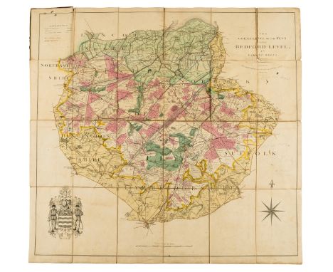
The Fens.- Wells (Samuel) The Great Level of the Fens Called Bedford Level, with calligraphic title cartouche, mileage scale, table of explanation, compass rose and the arms of the company which undertook the drainage, engraved map with contemporary hand-colouring, 840 x 815 mm (33 x 21 1/8 in), dissected and mounted on linen, some sections slightly lifting up from linen, minor nicks and surface dirt, folding with marbled endpaper, bound in contemporary red half morocco gilt over marbled boards, missing spine and lower cover, very worn, 8vo, G. & J. Cary, 1829

Lot 13

NO RESERVE England & Wales.- Bingley (James) The Official Travelling Map of England and Wales with part of Scotland, engraving with original hand-colouring, 595 x 485 mm (23 1/2 x 19 in), dissected and mounted on linen, spotting and browning, some surface dirt, folding, unframed, Thomas Tegg, 1825; together with 17 other maps of England and Wales by Kitchin, Abbe Gaultier, Rapin, Cruchley, and others, engravings, various sizes, all unframed, mainly 18th and 19th century (18)

Lot 42

London.- Agas (Ralph) London in the reign of Queen Elizabeth, panoramic view of London from the south, based on the earliest surviving map of London, lithograph on wove paper by Edward Weller, on two sheets conjoined, total sheet approx. 495 x 1270 mm (19 1/2 x 50 in), a good impression with minor spotting, handling creases, and light surface dirt, a few small nicks repaired verso unframed, Cassell, Petter & Galpin, [circa 1880s].

Lot 14

NO RESERVE England & Wales.- Lewis (Samuel) A Map of England and Wales, Divided into Counties, Parliamentary Divisions, & Dioceses, presented in four sections, covering the North East, South East, North West, and South West of England, with large decorative title upper right in the North East section, and large engraved view of The General Post Office London upper left in the North West, the view by Griffiths after Allom, engraved folding maps, drawn by R. Creighton, and engraved by J. Dower, each dissected and mounted on linen, all with hand-colouring, each approx. 1060 x 880 mm (41 3/4 x 34 5/8 in), occasional surface dirt, spotting and offsetting, folding into contemporary calf, gilt decorated borders, spines splitting, covers almost detached, rubbed, 8vo, S. Lewis & Co., 1840 (4)

Lot 3

British Isles.- Phillips (John) Geological Map of the British Isles and adjacent coast of France, engraved map by J.W. Lowry with full hand-colouring, sheet 825 x 660 mm (32 1/2 x 26 in), dissected and mounted on linen, some spotting and browning, minor surface dirt, folding into original cloth-covered boards, gilt title to upper cover, spine splitting, rubbed and worn, 8vo, Society for the Diffusion of Useful Knowledge, 1862.

Lot 93

NO RESERVE Africa.- Blaeu (Willem Jansz.) Aethiopia Inferior vel Exterior, map of South Africa covering the region from Congo-Zanzibar to the Cape, decorative title cartouche of a animal skin held aloft by two African men, engraving with outline hand-colouring on laid paper without visible watermark, platemark 385 x 500 mm. (15 1/4 x 19 3/4 in), sheet 440 x 535 mm (17 1/4 x 21 in), central vertical fold with minor repairs verso, French text verso, some browning and spotting, unframed, [circa 1635 or slightly later]

Lot 75

NO RESERVE Wales.- Speed (John) Glamorgan Shyre; The Countye of Monmouth; Breknoke, three welsh county maps, engravings without hand-colouring, on laid papers with grapes watermark, each sheet approx. 430 x 540 mm (16 7/8 x 21 1/4 in), some careful repairs to central vertical fold, each with excessive adhesive to lower sections within folds preventing them fully opening, rough edges, nicks and tears to extremities, some spotting and browning, unframed, Sudbury and Humble, [1627]; together with 9 further maps of Wales, including Blaeu's 'Mervinia et Montgomeria Comitatus', and 'Ceretica; Sive Cardiganensis Comitatus; Anglis Cardigan Shire', Kitchin's 'An Accurate Map of Brecknock Shire', and others by Weller, S.D.U.K., lithographs and engraving, various sizes, numerous splits, minor losses, surface dirt and browning, all unframed, 17th to 19th century (12)

Lot 68

Ireland.- [Bellin (Jacques Nicolas)] Carte Réduite des Isles Britanniques Cinquieme Feuille Contenant L'Irlande, large map and coastal chart of Ireland, engraving with hand-colouring, two sheets of laid paper conjoined, one sheet with watermark of double-headed eagle, platemark 900 x 580 mm (35 1/2 x 22 3/4 in), sheet 922 x 610 mm (36 1/4 x 24 in), old folds with some splitting, marginal damp-stains and surface dirt, light offsetting, Depot de la Marine stamp within map at lower centre, letterpress publisher's strip to lower left 'Au Magasin de Géographie ... chez Goujon ... Paris', [circa 1760].

Lot 150

NO RESERVE Military maps.- Philip & Son (George) Dunkirk to Berlin June 1940-July 1945, A Map of the Historic Wartime Journeys undertaken by The Right Hon. Sir Winston Churchill..., map of Churchill's travels during World War II, lithograph printed in colours, 910 x 1100 mm (35 3/4 x 43 1/4 in), folding as issued, minor surface dirt and light browning, folding into original slipcase with printed upper cover, rubbed, 8vo, [1956].

Lot 1

NO RESERVE British Isles.- Smith (Charles) Smith's New Map of the United Kingdom of Great Britain and Ireland..., large wall map with decorative title and inset map of Orkney and the Shetlands in the upper corners, engraving with original hand-colouring, on 6 large sheets joined into two sections, total size if all joined approximately 1820 x 1510 mm (71 5/8 x 59 1/2 in), old folds, some minor splitting, occasional minor marginal repairs, spotting and minor surface dirt, slightly rough edges in places, unframed, 1806 but corrected to 1811.

Lot 129

Iceland.- Bellin (Jacques Nicolas) Carte de l'Islande, pour Servir a la Continuation de l'Histoire Generale des Voyages, map of Iceland, engraving with hand-colouring, sheet 310 x 390 mm (12 1/4 x 15 3/8 in), old folds, some minor spotting and surface dirt, unframed, [circa 1780]; together with an impression of Fullarton & Co.'s 'Danish Islands in the North Atlantic Ocean', with maps of Iceland and the Faroe Islands, lithograph with hand-colouring, 470 x 315 mm (18 1/2 x 12 in), minor nicks, some surface dirt, unframed, [circa 1860s] (2).

Lot 111

Denmark.- Homann (Johann Baptist) Tabula Generalis Iutiae, Continens Dioeceses Quatuor, Alburgensem, Wiburgensem, Ripensem et Arhusiensem, quae et sunt Divisae in Omnia sua Dominia..., map of northern Denmark with large pictorial title cartouche with the king and queen of ancient Jutland in the upper left, engraving with full original hand-colouring, 585 x 500 mm (23 x 19 3/4 in), central horizontal fold with splitting, minor toning and surface dirt, small marginal loss to upper left corner, unframed, [circa 1716].

Lot 66

Ireland.- Moll (Herman) A New Map of Ireland Divided into its Provinces, Counties and Baronies..., large map of Ireland with inset plans of Dublin, Cork, Kinsale, Limerick, Waterford and Galway, and one of the Giants' Causeway, engraved map with hand-colouring, on two sheets of laid paper conjoined, total sheet 1030 x 635 mm (4 1/4 x 24 1/2 in), old folds with minor splitting, small repairs visible verso, minor nicks to extremities, some browning, handling creases and surface dirt, unframed, 1714.

Lot 80

World.- Hardy (John, Eton College Teacher of Mathematics & Writing Master, 1770s) and Thomas Bowen. A new projection of the Eastern Hemisphere of the earth on a plane; A new projection of the Western Hemisphere of the earth on a plane, unusual double-hemisphere world map projection, engraving with some hand-colouring, two sheets conjoined, total size 270 x 470 mm (10 5/8 x 18 1/2 in), old folds and minor handling creases, right edge carefully re-margined, unframed, F. Newbery, 1776.⁂ Western Hemisphere shown shortly before the discovery of Hawaii, with the Eastern Hemisphere featuring both New Guinea and Tasmania attached to Australia.

Lot 103

Belgium.- Ortelius (Abraham) Leodiensis Dioecesis Typus, map showing the Muese River valley including Namur and Liege, with west oriented at top of map, engraving with full hand-colouring, platemark 380 x 492 mm (15 x 19 1/4 in), sheet 470 x 580 mm (18 1/2 x 22 3/4 in), Latin text verso, spotting and surface dirt, unframed, [Antwerp, circa 1584].

Lot 149

NO RESERVE Middle East.- Escape map on silk.- War Office (Geographical Section) Cairo; Alexandria - Torbuch, "restricted" military intelligence escape map, first edition, lithograph printed in colours on silk, sheet 570 x 680 mm (21 1/4 x 24 in), some surface dirt and abrasion, old folds, thinning in places, unframed, 1953.

Lot 112

Europe.- War of the Spanish Succession.- [Plan of the Siege of Menen], broadside with large engraved plan showing the fortifications of Menen, with inset map of Dendermonde, German letterpress text below, on two sheets conjoined, total sheet 605 x 390 mm (23 3/4 x 15 1/4 in), old folds with splitting repaired verso, some minor surface dirt, unframed, Nuremberg, 1706 § Fricx (Eugene Henry) Plan du Siege de Bouchain, engraved plan with letterpress key in French below, two sheets conjoined, total sheet 485 x 465 mm (19 x 18 1/4 in), handling creases, some small repairs, unframed, Brussels, 1711 (2)

Lot 89

Africa.- Morocco.- Mercator (Gerard) and Claudius Ptolemy. Africae I Tab:, Ptolemaic map of the northwestern part of Africa, filled with ancient names, including the Straits of Gibraltar, here called the Herculeu fretum, engraving with hand-colouring, on thick laid paper without watermark, platemark 330 x 465 mm (13 x 18 1/4 in), sheet 410 x 530 mm (16 x 20 7/8 in), central vertical fold with some old splitting, marginal spotting and surface dirt, unframed, [circa 1578].

Lot 288

Map of Somersetshire, a view of Somerset originally drawn by Thomas Bowen George, published by Alex Hogg, 16.5cm x 20.5cm (the visible plate)Condition report: Wear in line with age, the frame damaged

Lot 313

A hand coloured map of Northumberland in a hogarth frame

Lot 222

A set of forty Birmingham Mint sterling silver “Ancient Counties of England” commemorative medals, 1977, in fitted case, with descriptive notes, & reproduction folding Blaeu map.

Lot 46

A vintage French coloured folding map “Foret De Fontainbleau Par Denecourt” (Forest of Fontainbleau), display in glazed frame, 23” x 21”.

Lot 47

A vintage French coloured folding map “Paris Metropolitan”, 19¾” x 37¼”; & two vintage British coloured folding maps “London Underground”, 17” x 22¼” & “Kew Royal Botanic Gardens”, 21¼” x 16¼”, each in glazed frame.

Lot 48

Two large coloured geological maps of “Great Britain “(Sheet 1 & 2), (2nd Edition 1957), 32½” x 41½”; & a Hagstrom’s coloured map of “New York Subways Elevated Lines”, 27” x 19”, each in glazed frame.

Lot 225

Two plastic cases with 62 drawers of 00 HO Gauge electric spares, red case with 48 drawers includes, bulbs, variable resistors, fixed resistors, capacitors, Jack plugs and sockets, magnets, diodes, LED's, Transistors, Bridge rectifiers, brown case includes OO Gauge wheels, motor, couplings, PTFE grease, bogies and other spares, Hornby inclined piers, platform LMS map, generally VG (qty)

Lot 272

Railway Related Ephemera, a group of black and white Ex Christies photographs of lots consigned for auction includes steam models, paintings, signs and others many by A C Cooper (80+) mostly 8" x 6" and smaller, together with 1927 Bartholomew's map of the British Isles linen backed, Swiss Postal Routes map undated, various modern items of railway ephemera and a reproduction BR Service By Night Poster, F-G, (Qty)

Lot 755

Original French railway station metal sign, 2nd classes with Paris-Landy plastic insert, and SNCF Reseau Voyageurs map to bottom half, c1994 in age, 77cm by 36cm.

Lot 396

A collection of assorted pictures and prints, to include framed embroideries, map of Sri Lanka and more, largest circa 68cm x 52cm

Lot 505

A collection of four pictures and prints, to include a Middle Eastern map depicting the Holy Lands, 20.5cm x 26cm, a Queen Elizabeth II Coronation tapestry and more, all framed and glazed

Lot 436

A pair of Nikon Nippon Kogaku J-B7 binoculars, in Nikon carry case; together with a reproduction map of North Shields and Tynemouth 1856; and The Readers Digest Great World Atlas. (3)

Lot 448

A map of Northumberland, after John Speed, in black and gilt frame, 45 x 58cms overall.

Lot 125

Horace WallerTHE LAST JOURNALS OF DAVID LIVINGSTONE IN CENTRAL AFRICA, FROM 1865 TO HIS DEATHLondon: John Murray, 1880FIRST EDITION, TENTH THOUSAND, 8vo, xx + 360, frontis + 6 plates, iii-[viii] + 346 + [2] pub cat pp, frontis + 14 plates + folding map; two volumes bound as one, original cloth with gilt, all edges gilt, spine covering loose along one joint with two tears, joint cracked, one page with outer corner cut within marginPROVENANCEJürgen Witt Collection

Lot 123

Henry M StanleyHOW I FOUND LIVINGSTONE IN CENTRAL AFRICA INCLUDING AN ACCOUNT OF FOUR MONTHS? RESIDENCE WITH DR LIVINGSTONENew York: Scribner, Armstrong & Co, 1872FIRST AMERICAN EDITION, 8vo, xxiii + 736 + [iv] pub cat pp, 28 plates + 5 maps of which 4 folding, rebound with original green buckram and gilt laid down, wear to boards, title page with foxing and heavier on protective tissue, hinge at eps cracked, some plates with offsetting; first map with age toning and two 4cm tears from hinge, map detached from first column of panels, tears along folds and intersections of folds; another map with one panel loose and some tears from edge the longest 5cmPROVENANCEJürgen Witt Collection

Lot 98

Captain William Cornwallis-HarrisWILD SPORTS OF SOUTHERN AFRICALondon: Henry G Bohn, 1852FIFTH EDITION, 8vo, xvi + 359pp, frontis + 24 plates, one fold out map, rebound in brown cloth with gilt and blind tooling, light wear, all edges gilt, light wear and soiling, corners bumped, fold line in center of spine, frontis backed with loss along gutter edge, foxing and tanning in prelims, light foxing on platesPROVENANCEJürgen Witt Collection

Lot 102

John Hanning SpekeJOURNAL OF THE DISCOVERY OF THE SOURCE OF THE NILEEdinburgh & London: William Blackwood and sons, MDCCCLXIII [1863]FIRST EDITION, 8vo, xxxi + 658 pp, frontis + 26 plates + two maps of which one folds out, half bound in brown morocco, marbled text block edge, wear on front joint, back joint split, foxing and tanning in pre- and endlims, folding map with light foxing and small tears at intersections of foldsPROVENANCEJürgen Witt Collection

Lot 124

Horace WallerTHE LAST JOURNALS OF DAVID LIVINGSTONE IN CENTRAL AFRICA, FROM 1865 TO HIS DEATH, 2 VOLSLondon: John Murray, 1874FIRST EDITION, 8vo, Vol I: xvi +360 + 6 pub cat pp, frontis + 6 plates + 1 folding map in end pocket, Vol II: viii + 1 ? 320, 337 ? 346 + 20 pub cat pp, frontis + 14 plates + one folding map; original cloth with gilt, spines faded; Vol I: front and back hinge cracked as well as in two other places in text block, foxing in prelims, folding map with short tears at intersections and age toning on verso; Vol II: 17 pages absent, front hinge cracked as well as one other place in text block, foxing in eps, short tear in one page margin, folding map with foxing(2)PROVENANCEJürgen Witt Collection

Lot 112

Verney Lovett CameronACROSS AFRICA, 2 VOLSLondon: Daldy, Isbister & Co, 1877FIRST EDITION, 8vo, Vol I: xvi + 389 + [4] pub cat pp, frontis + 14 plates + folding map in pocket; Vol II: xii + 366 + 8 pub cat pp, frontis + 17 plates; blue cloth with gilt, foxing on text block edge; Vol I: back hinge starting, some plates with foxing; Vol II: foxing in prelims, hinge opening in one place(2)PROVENANCEJürgen Witt Collection

Lot 103

James Augustus GrantA WALK ACROSS AFRICA OR DOMESTIC SCENES FROM MY NILE JOURNALEdinburgh and London: William Blackwood and sons, MDCCCLXIV [1864]FIRST EDITION, 8vo, xviii + 452 + [1] + [i] pub cat pp, rebound and original boards covered, edges of boards and spine head and tail caps taped, two chips to text block edge, eps and half title absent, tp loose, foxing, 3cm tear in margin of two pages, soiling in gutter of a few pages, a short tear in three pages and another with a 4cm tear continuing into a fold across the page, one page with top to bottom closed tear repaired with tape, map and 31 publisher's catalogue pages absentPROVENANCEJürgen Witt Collection

Lot 82

Frederick Courteney SelousTRAVEL AND ADVENTURE IN SOUTH-EAST AFRICASalisbury: The Pioneer Head, 1972 (Heritage Series Volume 5)COLLECTORS' EDITION #13 of 90 of 2000, FACSIMILE REPRINT of 1893 edition, 8vo, 503pp, 22 plates + one folding map, quarter green morocco with brown cloth and gilt, top edge gilt, slipcase, spine faded, light wear to slipcasePROVENANCEJürgen Witt Collection

Lot 107

Dr. Georg SchweinfurthTHE HEART OF AFRICA, THREE YEARS? TRAVELS AND ADVENTURES IN THE UNEXPLORED REGIONS OF CENTRAL AFRICA FROM 1868 TO 1871, 2 VOLSNew York: Harper & Brothers, 1874FIRST AMERICAN EDITION, 8vo, Vol I: xvi + 559pp, frontis + 13 plates + one tinted plate + one folding map; Vol II: x + 521 + 6 pub cat pp, frontis + 10 plates + one map; original brown and gilt cloth, light wear to boards; Vol I: front hinge starting, note from Schweinfurth laid down on epVolume I includes a 1875 map of Schweinfurth's journey from Petermann?s Geographische Mittheilungen(2)PROVENANCEJürgen Witt Collection

Lot 90

W G BrowneTRAVELS IN AFRICA, EGYPT, AND SYRIA, FROM THE YEAR 1792 TO 1798London: Printed for T Cadell and W Davies & Longman, Hurst and Orme, 1806SECOND ENLARGED EDITION, 4to, xxxv + 632pp, frontis + three folding maps + one plan, black morocco and gilt, light wear on boards, bookplate on ep, front hinge loose from text block, prelims and first 16 pages loose, text page evenly age toned, 234 with 10cm tear in page, three pages with top section loose and one page with a 1,5cm hole not affecting text, plates and maps with offsetting and age toning, first folding map with tear along one edge of a panel, two other folding maps with multiple tears and tape repairs the longest 30cmPROVENANCEJürgen Witt Collection

Lot 126

THE LIFE & EXPLORATIONS OF DR LIVINGSTONELondon: Adam & Co, c1876Large 4to, viii + 632pp, frontis and half title colour lithographs + 18 sepia lithographs and one B&W + one map, dark brown morocco with gilt, all edges gilt, light wear to spine and joints, corners bumped, foxing in prelims, back hinge cracked, some foxing and age toning in gutter of some pages, light foxing elsewherePROVENANCEJürgen Witt Collection

Lot 113

Major Serpa PintoHOW I CROSSED AFRICA FROM THE ATLANTIC TO THE INDIAN OCEAN, THROUGH UNKNOWN COUNTRIES; DISCOVERY OF THE GREAT ZAMBESI AFFLUENTS, &C., 2 VOLSLondon: Sampson Low, Marston, Searle, & Rivington, 1881FIRST EDITION, 8vo, Vol I: xxx + 377 + 32 pub cat pp, 8 plates + numerous in text illustrations + 6 maps of which one folds out + one large folding map in back pocket; Vol II: vii + 388 pp, 17 plates + numerous in text illustrations + 2 maps; rebound in half morocco, new eps, ex-library with stamps, title page with foxing and heavier on facing tissue, foxing in prelims and sporadically throughout text; Vol I: large folding map with two panels loose along one fold and tears at fold intersections(2)PROVENANCEJürgen Witt Collection

Lot 120

David and Charles LivingstoneNARRATIVE OF AN EXPEDITION TO THE ZAMBESI AND ITS TRIBUTARIES; AND OF THE DISCOVERY OF THE LAKES SHIRWA AND NYASSA. 1858 - 1864London: John Murray, 1865FIRST EDITION, 8vo, [xv] + 608 + 32 pub cat pp, folding frontis + 12 plates + folding map, original brown and gilt cloth, new eps, damp mark on ep, wear to boards, head and tail cap worn, foxing on eps, previous owner?s name on title page, 5cm closed tear at hinge of folding map repaired with tapePROVENANCEJürgen Witt Collection

Lot 89

Frederick HornemanTHE JOURNAL OF FREDERICK HORNEMAN'S TRAVELS FROM CAIRO TO MOURZOUK, THE CAPITAL OF THE KINGDOM OF FEZZAN, IN AFRICA. IN THE YEARS 1797-8London: Printed by W Bulmer for G & W Nicol, 1802FIRST EDITION, 4to, iv + xxvi + 195pp, 3 maps of which 2 fold out, half bound with marbled boards, front board loose, brown discolouration in proximity of leather, foxing and age toning in prelims, pencil note on one page, last third of text pages age toned, last 10 pages with foxing; one folding map with 2cm tear at hinge and a short tear at a fold intersection, the other folding map with 6cm tear at hinge and a short tear at a fold intersectionPROVENANCEJürgen Witt Collection

Lot 88

Mungo ParkTRAVELS IN THE INTERIOR DISTRICTS OF AFRICA: PERFORMED UNDER THE DIRECTION AND PATRONAGE OF THE AFRICAN ASSOCIATION IN THE YEARS 1795, 1796, AND 1797London: Privately Published, 1799FIRST EDITION, 4to, xxviii + 372 + xcii + [6] pp, 5 plates of which 2 fold out + 3 folding maps, rebound with original morocco laid down, first 60 pages age toned and heavy age toning in post script, foxing; first folding map: age toning, three tears at fold intersections the longest 4cm, three tears in margins; second folding map: age toning, a few tears the longest 12cm; third map and folding plates with offsetting, and other plates with damp stain in top marginsPROVENANCE Jürgen Witt Collection

Lot 119

David LivingstoneMISSIONARY TRAVELS AND RESEARCHES IN SOUTH AFRICA INCLUDING A SKETCH OF SIXTEEN YEARS? RESIDENCE IN THE INTERIOR OF AFRICA, AND A JOURNEY FROM THE CAPE OF GOOD HOPE TO LOANDA ON THE WEST COAST; THENCE ACROSS THE CONTINENT, DOWN THE RIVER ZAMBESI, TO THE EASTERN OCEANLondon: John Murray, 1857FIRST EDITION, EARLY ISSUE, 8vo, [x] + 687 + 8 pub cat pp, one foldout frontis + portrait frontis + 22 plates + 3 maps of which two foldout and another in text + one fold out section plan, rebound with new eps, pocket map bound into textblock, name of previous owner on title page, tape repair to title page, hinge cracked, two 4 page sections with one loose stitch, tear along folds of section plan repairedPROVENANCEJürgen Witt Collection

Lot 87

The Hon. W. H. Drummond (Edward Hodges Illus)THE LARGE GAME AND NATURAL HISTORY OF SOUTH AND SOUTH-EAST AFRICASalisbury: The Pioneer Head, 1972 (Heritage Series Volume 4)COLLECTORS? EDITION #13 of 90 of 1000, FACSIMILE REPRINT of 1875 edition, 8vo, xxi + 428pp, frontis + 13 plates + one map, quarter green morocco with green cloth and gilt, top edge gilt, slipcase, spine toned, light wear to slipcasePROVENANCEJürgen Witt Collection

Lot 97

Robert MoffatMISSIONARY LABOURS AND SCENES IN SOUTHERN AFRICALondon: John Snow, 1842FIRST EDITION, FOURTH THOUSAND, 8vo, [8] pub cat + xvi + 624pp, colour frontis + 8 plates + one folding map, rebound with board and spine covers laid down, light wear to boardsPROVENANCEJürgen Witt Collection

Lot 100

Paul B du ChailluEXPLORATIONS & ADVENTURES IN EQUATORIAL AFRICA WITH ACCOUNTS OF THE MANNER AND CUSTOMS OF THE PEOPLE, AND OF THE CHACE OF THE GORILLA, CROCODILE, LEOPARD, ELEPHANT, HIPPOPOTAMUS, AND OTHER ANIMALSLondon: John Murray, 1861FIRST EDITION, 8vo, xviii + 479 + [28] pub cat pp, 28 plates one of which folds out + one folding map, rebound in brown with new eps, remains of bookplate and inscription in eps, name of previous owner on preface, foxing, age toning towards edges of pages, folding map with 4cm tear at hinge and small tear at fold intersectionPROVENANCEJürgen Witt Collection

Lot 116

Hermann von WissmannMY SECOND JOURNEY THROUGH EQUATORIAL AFRICA FROM THE CONGO TO THE ZAMBESI IN THE YEARS 1886 AND 1887London: Chatto & Windus, 1891FIRST ENGLISH EDITION, 8vo, xiv + 326 pp, frontis + 31 plates + one folding map, half bound in red morocco with marbled boards, wear along joints, hinges cracked, names of previous owners in eps, foxing and tanning in pre- and end-lims, one plate loose, two short tears in marginsPROVENANCEJürgen Witt Collection

Lot 74

Jane Curruthers (ed)THE JAMESON RAID: A CENTENNIAL RETROSPECTIVEJohannesburg: Brenthurst Press, 1996 (Volume 1) LIMITED to 1025, 4to, 264pp, illustrated, Brodart cover, top edge gilt Brian Warner & John RourkeFLORA HERSCHELIANA: SIR JOHN AND LADY HERSCHEL AT THE CAPE, 1834 TO 1838Johannesburg: Brenthurst Press, 1996 (Volume 2) LIMITED to 1025, 4to, 295pp, illustrated, Brodart cover, top edge gilt, light foxing on dj Iain R Smith (ed)THE SIEGE OF MAFEKING, 2 VOLUMESJohannesburg: Brenthurst Press, 2001 (Volume 3 & 4) LIMITED to 1020, 4to, 239 & 529pp, illustrated, Brodart cover, top edge gilt LC Rookmaaker, PJ Mundy, IE Glenn & EC SparyFRANCOIS LEVAILLANT AND THE BIRDS OF AFRICAJohannesburg: Brenthurst Press, 2004 (Volume 5) LIMITED to 1070, 4to, 484pp, profusely illustrated + map in back pocket, Brodart cover, top edge gilt, light foxing on dj(5)

Lot 110

Joachim John MonteiroANGOLA AND THE RIVER CONGO, 2 VOLSLondon: Macmillan, 1875FIRST EDITION, 8vo, Vol I: viii + [2] + 305 + 28 catalogue pp + [4]pp, 1 folding map + 9 B&W plates; Vol II: iv + [2] + 340pp, 7 B&W plates; original green and gilt pictorial cloth, light soiling and wear on boards and hinges, corners bumped, head- and tailcap slightly stretched, foxing; Vol I: hinge opening in two places, heavy foxing on a few of the catalogue pages; Vol 2: hinge opening in three places, few pages with damp stain in gutter(2)PROVENANCEJürgen Witt Collection

Lot 83

Alice Blanche BalfourTWELVE HUNDRED MILES IN A WAGGONSalisbury: The Pioneer Head, 1970 (Heritage Series Volume 2)COLLECTORS' EDITION #29 of 140 of 1500, FACSIMILE REPRINT of 1895 edition, 8vo, xix + 265pp, colour frontis and B&W frontis + 3 colour and 13 B&W plates + one folding map, quarter blue morocco with blue cloth and gilt, top edge gilt, slipcase with gilt, spine faded, toning on bottom edge of text block next to spine, wear, foxing and toning to slipcasePROVENANCEJürgen Witt Collection

Lot 104

Samuel White BakerTHE ALBERT N'YANZA, GREAT BASIN OF THE NILE AND EXPLORATIONS OF THE NILE SOURCES, 2 VOLSLondon: Macmillan, 1866FIRST EDITION, 8vo, Vol I: xxx + 395pp, 7 plates + 2 maps one of which folds out; Vol II: xi + 384pp, 6 plates; half bound with marbled boards and marbled text block edge, corners bumped, wear along edges, heavy foxing in pre- and endlims, light foxing and brown marks on some text pages; Vol I: front hinge detached from textblock, small stain on text block edge, two eps loose, light foxing and brown marks on some text pages, foxing on folding map; Vol II: name plate of previous owner in eps, front hinge crackedPROVENANCEJürgen Witt Collection

Lot 1512

A framed map - The County Palatine of Lancaster (Lancashire) by Robert Morden C.1695, 39.5 x 45cm - NO RESERVE

Lot 1739

A Philips complete map of London and Suburbs.

Lot 237

A large framed map of the world

Lot 255

AFTER RAWLINGS, COLOURED PRINT, AND A REPRODUCTION MAP OF NORFOLK (2)

Lot 355

RETRO GLASS TOP COFFEE TABLE INSET WITH A MAP OF THE WORLD, 132CM WIDE

Loading...Loading...
  • 109182 item(s)
    /page

Recently Viewed Lots