We found 109182 price guide item(s) matching your search
There are 109182 lots that match your search criteria. Subscribe now to get instant access to the full price guide service.
Click here to subscribe- List
- Grid
-
109182 item(s)/page


![Diverse grafiek, 20e eeuw [map]](https://cdn.globalauctionplatform.com/19feca2e-4282-46ee-82dc-ae8000ccec39/5c8c79f8-6173-480b-9b62-ae83009b98d8/468x382.jpg)
![Jan Riske (geb. 1932) Diverse tekeningen [map+4] 20 x 30 cm. tot 70 x 70 cm.](https://cdn.globalauctionplatform.com/19feca2e-4282-46ee-82dc-ae8000ccec39/59ddf7fd-c102-4af9-bf00-ae83009bb208/468x382.jpg)


![Toon Teeken (geb. 1944) Vijf diverse litho's. Hierbij drie litho's door Dirk Wiarda. [map]](https://cdn.globalauctionplatform.com/19feca2e-4282-46ee-82dc-ae8000ccec39/5e693c53-b76f-47b1-856f-ae83009cc050/468x382.jpg)
![Jan Riske (geb. 1932) Collectie tekeningen [map]](https://cdn.globalauctionplatform.com/19feca2e-4282-46ee-82dc-ae8000ccec39/4efb5cc6-1414-49ab-87cb-ae83009bb01e/468x382.jpg)
![Willy Boers (1905-1978) Map met grote collectie tekeningen, naakten [map] deels met atelierstempel, ca. 25 x 35 cm.](https://cdn.globalauctionplatform.com/19feca2e-4282-46ee-82dc-ae8000ccec39/e1aa36dd-e006-4193-ab9a-ae830097a61e/468x382.jpg)
![Carel Visser (1928-2015) Twee houtsnedes [map] tweemaal houtsnede, gesign., ca. 70 x 90 cm.](https://cdn.globalauctionplatform.com/19feca2e-4282-46ee-82dc-ae8000ccec39/b52c9ec3-fe4f-4125-bd5a-ae83009cdc2c/468x382.jpg)
Lot 5009
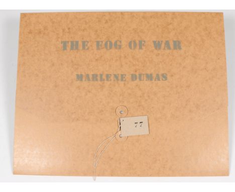
Marlene Dumas (geb. 1953) 'Fog of war'. De complete map, met 4 maal digital print en 1 blad met tekst in de originele omslag [1] vier maal digital print, genummerd 77/80, 45 x 30 cm. The complete portfolio, comprising four digital prints in colours, 2006, each signed in pencil, titled, dated, numbered 76/80, with text by the artist, loose (as issued), contained in the original brown card portfolio with printed artist's name and title
![Toegeschreven aan Anton Mauve (1838-1888) Blad met studies van een schaap en koeien [map] olieverf op papier, gesign. met ini](https://cdn.globalauctionplatform.com/19feca2e-4282-46ee-82dc-ae8000ccec39/7d66cb48-4b1d-4278-b34a-ae8300894e09/468x382.jpg)
![Dirkje Kuik (1929-2008) Map met een tekening, een litho en een litho waarop getekend [1] map 50 x 35 cm.](https://cdn.globalauctionplatform.com/19feca2e-4282-46ee-82dc-ae8000ccec39/a4edd204-524d-4fbb-8f7a-ae830089a433/468x382.jpg)

Lot 4542
Jan Toorop (1858-1928) Correspondentie tussen Jan Toorop en J.J.N. Exter, directeur van het Gebouw voor Beeldende Kunst, Vondelstraat 80. Betreffende een tentoonstelling met werken van Toorop in 1923. Tevens het voorwoord voor de catalogus van de tentoonstelling, geschreven door Miek Janssen, en drie tekeningen, ontwerpen voor kerkramen, toegeschreven aan Jan Toorop. [map]

![Marlene Dumas (geb. 1953) 'Motherhood' [map] litho, gesign., 24/40, 35,5 x 38 cm.](https://cdn.globalauctionplatform.com/19feca2e-4282-46ee-82dc-ae8000ccec39/b81e3942-5d78-4eae-b617-ae83009b8a16/468x382.jpg)
![Anthonie Lodewijk Koster (1859-1937) 'Aan de Houtvaart' / 'Het vroegere Schoter voetpad' [map] houtskool en pastel, gesign.,](https://cdn.globalauctionplatform.com/19feca2e-4282-46ee-82dc-ae8000ccec39/ff94baff-59b1-4da7-9b73-ae83008f093b/468x382.jpg)
![Edgar Fernhout (1912-1974) Vier diverse litho's. Hierbij gravure, 18e eeuw. [map]](https://cdn.globalauctionplatform.com/19feca2e-4282-46ee-82dc-ae8000ccec39/94a65688-5348-43c3-9f12-ae83008978ed/468x382.jpg)

![Leo Gestel (1881-1941) Collectie van negen diverse tekeningen [map] negen tekeningen, twee gesigneerd en gedateerd 1932, 20 x](https://cdn.globalauctionplatform.com/19feca2e-4282-46ee-82dc-ae8000ccec39/371ba2dd-2909-4391-8504-ae83009753bc/468x382.jpg)
![Hugo Kaagman (geb. 1955) 'Fez', suite van 9 litho's. Hierbij litho, 'Elvis'. [map] 10 litho's, gesign. 50 x 50 cm. en 65 x 5](https://cdn.globalauctionplatform.com/19feca2e-4282-46ee-82dc-ae8000ccec39/c15c027b-e7c4-4918-8037-ae83009bb84b/468x382.jpg)
![Reinhoud D'Haese (1928-2007) 'Impromptu'. Map met zeven etsen met gedichten door Hugo Claus. [1] zeven diverse etsen, gesign](https://cdn.globalauctionplatform.com/19feca2e-4282-46ee-82dc-ae8000ccec39/69b7279c-2679-403d-8875-ae83009ca81b/468x382.jpg)
![Robert Zandvliet (geb. 1970) 'Fly overs' [map] 4 litho's, gesign., 16/40, 2002, 76 x 57 cm.](https://cdn.globalauctionplatform.com/19feca2e-4282-46ee-82dc-ae8000ccec39/10e12004-d65a-47a5-a83b-ae830099ed97/468x382.jpg)
![Diverse moderne kunst [map]](https://cdn.globalauctionplatform.com/19feca2e-4282-46ee-82dc-ae8000ccec39/f0953ad1-6c11-4a9e-8c57-ae83009cd324/468x382.jpg)
![Erik Andriesse (1957-1993) 'Sam' [map] litho, niet ingelijst, gesign., 1992, 54/60, 65 x 50 cm.](https://cdn.globalauctionplatform.com/19feca2e-4282-46ee-82dc-ae8000ccec39/3d372e13-314f-4426-92e0-ae83009b9113/468x382.jpg)
![Marlene Dumas (geb. 1953) 'Incubatie' [map] litho, gesign., 34/40, 33 x 31 cm.](https://cdn.globalauctionplatform.com/19feca2e-4282-46ee-82dc-ae8000ccec39/79c0c6b5-cf47-455f-99bf-ae83009b888e/468x382.jpg)
![Anton Heijboer (1924-2005) Vier diverse tekeningen [map]](https://cdn.globalauctionplatform.com/19feca2e-4282-46ee-82dc-ae8000ccec39/fee60631-3017-48d8-b568-ae83009cb079/468x382.jpg)

![David Tremlett (geb. 1945) 'Between you and me' map met 15 aquatints/zeefdrukken, allen gesign., 2006, 27/50, 34 x 34 cm. [1]](https://cdn.globalauctionplatform.com/19feca2e-4282-46ee-82dc-ae8000ccec39/7e960578-a927-4d07-bfc5-ae830099fd8e/468x382.jpg)

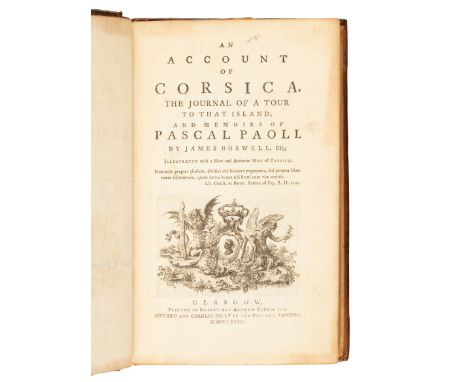
Lot 129
BOSWELL, James (1740-1795). An Account of Corsica, the Journal of a Tour to that Island; and Memoirs of Pascal Paoli. Glasgow: Robert and Andrew Foulis for Edward and Charles Dilly, 1768. 8vo (195 x 125 mm). Half-title, engraved vignette on title-page, D2, E2 and Z3 are cancellans, with final blank; engraved folding map (short tear to fold). Contemporary calf (neatly rebacked preserving old spine label and endpapers). Provenance: Abel E. Berland (bookplate). FIRST EDITION, of the work which secured Boswell's place in London's literary and political circles, with the map in the first state. ESTC T26157; Gaskell 473; Pottle 24; Rothschild 442.Property from the Annette Perlman Trust
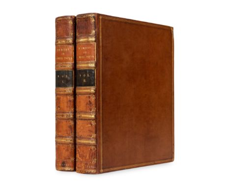
Lot 217
PEPYS, Samuel (1633-1703). Memoirs of Samuel Pepys. Comprising His Diary from 1659 to 1669. London: Henry Colburn, 1825. 2 volumes, 4to (299 x 225 mm). Half-titles, 13 engraved portraits and plates including one folding map, in-text illustrations, advertisement leaf in vol. I. (Some offsetting, spotting or staining). Contemporary calf gilt, spine in 6 compartments with 5 raised bands, brown and black lettering-pieces gilt, edges marbled (skillfully re-backed, some minor wear, a few light scuffs to sides); later beige cloth slip-case. Provenance: Hugh Percy, possibly (1785"“1847) 3rd Duke of Northumberland (bookplates).FIRST EDITION of Pepys' diary, which was in cipher until 1825, when it was deciphered by John Smith. Edited by Lord Braybrooke, the contents depict contemporary everyday life, making this a popular source of information about late 17-century England. Grolier English 75.Property from the Annette Perlman Trust
Lot 317
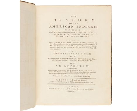
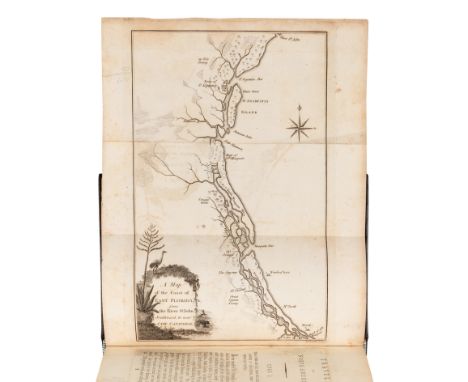
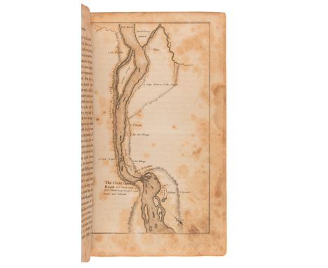
ADAIR, James (1709?-1783). The History of the American Indians; particularly those Nations adjoining to the Mississippi, East and West Florida, Georgia, South and North Carolina, and Virginia. London: for Edward and Charles Dilly, 1775. 4to (274 x 212 mm). Half-title; engraved folding map. (Some minor offsetting of map.) Contemporary green calf-backed marbled boards (some rubbing). FIRST EDITION of the "best 18th-century English source on the Southern tribes, written by one who traded forty years with them" (Howes). Adair lived and traded among several tribes, including the Cherokee, Catawba, and Chickasaw. ESTC T86841; Graff 10; Howes A-38 ( "best 18th century English source on the Southern tribes, written by one who traded forty years with them"); Sabin 155.Property from the Collection of Robert P. Hunter, Jr. and Barbara Hunter, Alpharetta, Georgia
Lot 341
BARTRAM, William (1739-1823). Travels through North and South Carolina, Georgia, East and West Florida ... London: J. Johnson, 1794.8vo (203 x 126 mm). Portrait frontispiece, folding map of the East coast of Florida, 7 copperplates (one folding). (Some spotting, some minor offsetting.) Later navy morocco gilt, marbled edges (some staining to edges).Second English edition. Only the title-page is new in this second edition, which is "unequalled for the vivid picturesqueness of its descriptions of nature, scenery, and productions" (Sabin). Contains observations regarding soil and natural productions in the Southeastern region of the United States as well as about the Native American populations that inhabited them during that period. Howes B-223; Sabin 3870.Property from the Collection of Robert P. Hunter, Jr. and Barbara Hunter, Alpharetta, Georgia
![[FUR TRADE]. CHITTENDEN, Hiram Martin (1859-1917). The American Fur Trade of the Far West. New York: Francis P. Harper, 1902.](https://cdn.globalauctionplatform.com/e1878e4e-bcc2-45b9-abd8-ae6e011505e8/bc268dba-b5a9-4a3e-89d9-ae700107fb97/468x382.jpg)
Lot 351
[FUR TRADE]. CHITTENDEN, Hiram Martin (1859-1917). The American Fur Trade of the Far West. New York: Francis P. Harper, 1902. 3 volumes, 8vo. Frontispieces in vols. I&II, 8 plates, folding map. (Some chipping, short tears in map crossing image, some soiling.) Publisher 's original green cloth gilt, edges uncut (light rubbing). FIRST EDITION of "the first modern history of the fur trade, and still a standard work on the subject" (Reese). Includes a history of the pioneer trading posts, early fur trade, and overland commerce. Graff 696; Howes C390; Rader 770; Reese Best of the West 231.Property from the Collection of Robert P. Hunter, Jr. and Barbara Hunter, Alpharetta, Georgia
![[FUR TRADE]. LARPENTEUR, Charles (1803-1872). Forty Years a Fur Trader on the Upper Missouri. Elliott COUES, editor. New York](https://cdn.globalauctionplatform.com/e1878e4e-bcc2-45b9-abd8-ae6e011505e8/75bb3f4a-5a41-4e0c-bf69-ae70010850e8/468x382.jpg)
Lot 352
[FUR TRADE]. LARPENTEUR, Charles (1803-1872). Forty Years a Fur Trader on the Upper Missouri. Elliott COUES, editor. New York: Francis P. Harper, 1898.2 volumes, 8vo. 2 portrait frontispieces, 2 folding maps, 14 plates. (Some minor staining, some toning, a few tears not affecting text.) Publisher 's blue cloth gilt, (some minor rubbing, spines darkened). FIRST EDITION, LIMITED ISSUE, number 511 of 950 copies. This important source on the history of fur trading contains Larpenteur 's narrative of forty years in the fur trade from 1833-1872.Graff 2404; Howes C800.[With:] CHITTENDEN, Hiram Martin (1859-1917). The American Fur Trade of the Far West. New York: Francis P. Harper, 1902. 3 volumes, 8vo. 10 plates; linen-backed folding map in vol. III rear pocket. (Some light toning, a few pencil markings.) Publisher 's green cloth gilt (some light rubbing, repairs to one spine). FIRST EDITION, one of 1,000 copies printed, of Chittenden 's definitive work. Graff noted that even "Sixty years after publication, this is still the great work on the subject." Graff 196; Howes C390; Rader 770; Streeter IV: 3206.Property from the Collection of Robert P. Hunter, Jr. and Barbara Hunter, Alpharetta, Georgia
![[GEORGIA] -- [MARTYN, Benjamin (1699-1763)]. Reasons for Establishing the Colony of Georgia... London: W. Meadows, 1733](https://cdn.globalauctionplatform.com/e1878e4e-bcc2-45b9-abd8-ae6e011505e8/a0cdfdfc-d2d6-4345-ba41-ae7001094767/468x382.jpg)
Lot 355
[GEORGIA] -- [MARTYN, Benjamin (1699-1763)]. Reasons for Establishing the Colony of Georgia... London: W. Meadows, 1733. 4to (233 x 171 mm). Engraved frontispiece by T. Pine; engraved map (small hole to blank area repaired verso, short marginal tear repaired verso); engraved tail-piece by T. Pine. (Upper margin trimmed very slightly shaving woodcut head-piece on one leaf, a few minor stains.) Modern half calf gilt. Provenance: Long Island Historical Society (stamp on title-page). FIRST EDITION, THE PREFERRED SECOND ISSUE, with the 8-page "Postscript" containing a letter from Georgia founder James Oglethorpe, and with the map in the second state as usual. Benjamin Martyn acted as chief publicity agent for Oglethorpe's planned colony, and here recounts the primary benefits to Great Britain for the founding of a new colony. His name did not appear on the title-page until the second edition, published later in the same year. With the map in the second state, having "S Augustin" located below "Matansas." "A well-written tract; plausible in its arguments, glowing in its descriptions, valuable for its information, and pertinent in its appeals to the philanthropic and benevolent" (Sabin 45002). Cumming Southeast 211 (map); De Renne, p. 45; Howes M-356; Streeter Sale 1144.Property from the Collection of Robert P. Hunter, Jr. and Barbara Hunter, Alpharetta, Georgia
![[INDIANA]. COLTON, Joseph H. (1800-1893). The State of Indiana Delineated. New York: J.H. Colton, 1838. 16mo (93 x 141 mm)](https://cdn.globalauctionplatform.com/e1878e4e-bcc2-45b9-abd8-ae6e011505e8/23ab82d4-73be-47b2-9eb6-ae70010c220f/468x382.jpg)
Lot 371
[INDIANA]. COLTON, Joseph H. (1800-1893). The State of Indiana Delineated. New York: J.H. Colton, 1838. 16mo (93 x 141 mm). Engraved folding map with hand-coloring, publisher's advertisement. (Some separations on map folds, some spotting.) Original morocco-backed boards, paper label on upper cover (some wear and light dampstaining, upper cover with a few slice-marks). Provenance: George Robinson (signature dated 1839 on flyleaf). FIRST EDITION, including the map, which is often cited as being printed separately, but whose inclusion is mentioned on the printed label on the front cover in the present copy. The map includes overland routes to western territories, including Texas, Oregon, and California. Bradford 1005 ( "Vastly more correct than any other pocket map of Indiana, and with the book, will be found a valuable directory and guide for travellers to that state"); Howes C-622; Sabin 34577; Streeter Sale 1416.
Lot 372
LEWIS, Meriwether (1774-1809). CLARK, William (1770-1838). History of the Expedition... Philadelphia: Bradford and Inskeep, 1814.2 volumes, 8vo (204 x 127 mm). With 5 (of 6) plates and maps (lacking the large map). (Several leaves, including the title-page to vol. I, with repairs occasionally affecting text, spotting and staining.) Contemporary calf (modern rebacking, recornered, some wear). FIRST EDITION OF THE "MOST IMPORTANT OF ALL OVERLAND NARRATIVES," (Grolier American), AND THE "DEFINITIVE ACCOUNT OF THE MOST IMPORTANT EXPLORATION OF THE NORTH AMERICAN CONTINENT" (Wagner-Camp)President Thomas Jefferson, who commissioned the expedition and ensured its funding by Congress in 1803, contributed a prefatory "Life of Captain Lewis" to the work. Publication was delayed by the death of Lewis, but the work was finally brought to press on 20 February 1814 by Bradford and Inskeep. Of the 2,000 copies that were printed, only 1,417 were perfect and put out for sale. According to Elliott Coues, "the map is gone from many if not most of the copies of the book now extant. ..[It] was not inserted in all copies of the original edition." Church 1309; Grolier American 30; Howes L-317; Sabin 40829; Streeter III: 1777; Wagner-Camp 13:1.
Lot 373
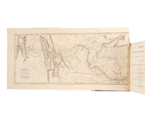
LEWIS, Meriwether (1774-1809) and William CLARK (1770-1838). Travels to the Source of the Missouri River and Across the American Continent to the Pacific Ocean. London: Longman, Hurst, Rees, Orme, and Brown, 1814.4to (267 x 210 mm). Engraved folding map after Clark by S. Lewis (short tear at fold, some minor offsetting), 5 engraved maps and plans on 3 leaves. (Lacking half-title, a few small stains.) 20th-century quarter calf, corners vellum-tipped (extremities very slightly rubbed). Provenance: Sir John Francis Davis, 1st Baronet (1795-1890), British diplomat, first President of the Royal Asiatic Society Hong Kong (bookplate, signature on flyleaf); Milburn McCarty Jr. (stamp on flyleaf).FIRST ENGLISH EDITION OF THE AUTHORIZED ACCOUNT OF "THE MOST IMPORTANT WESTERN EXPLORATION" (Howes). Lewis and Clark intended to publish their journals after the completion of their 1804-1806 expedition, but their official duties and Lewis's death in 1809 delayed publication. Nicholas Biddle edited the text of the first American edition with the assistance of Paul Allen, and the first edition was published in Philadelphia in 1814. The present edition was edited by Thomas Rees from sheets of the first American edition; he notes, "the only liberty that has been taken with the language, has been merely the correction of a few inadvertent grammatical or typographical errors" (p. xiv). His introduction includes Jefferson's "Message on the Subject of this Expedition" of 19 February 1806 (pp. viii-ix) and an extract from Lewis's "Fort Mandan" letter of "17" [i.e. 7] April 1805 to Jefferson (pp. x-xii). Hill, p.180 ("one of the most interesting narratives of North America in existence"); Sabin 40829; Wagner-Camp 13:2.Property from the Collection of Robert P. Hunter, Jr. and Barbara Hunter, Alpharetta, Georgia
Lot 376
[MAP]. BRY, Theodor de (1528-1598) and John WHITE (1540-1593). Americae pars, nunc Virginia dicta primum ab Anglis. Frankfurt, 1590. Engraved map of Virginia. (Some minor toning, a few tiny spots.) Overall sheet 330 x 458 mm. Matted and framed. Royal arms of England, decorative cartouche, compass rose, ships, canoes, and sea monsters. "ONE OF THE MOST SIGNIFICANT CARTOGRAPHICAL MILESTONES IN COLONIAL NORTH AMERICAN HISTORY... THE MOST ACCURATE MAP DRAWN IN THE SIXTEENTH CENTURY OF ANY PART OF THAT CONTINENT" (Burden)Second state, with the initial "C" superimposed on the letter "E" in "Chesepiooc." The first map to depict and name the Chesapeake Bay ("Chesepiooc Sinus"), and the second map of Roanoke, after John White's manuscript map. White accompanied Raleigh's voyage in 1585, and served as governor of the ill-fated Roanoke settlement. The map depicts the coast from the Cape Lookout to the Chesapeake Bay; it influenced other 16th-century maps of the region by de Jode, Wytfliet, and Metellus. De Bry produced White's map to show the west along the top edge rather than north, which became the preferred orientation for mapmakers until the 18th-century. Burden 76; Cumming Southeast 3.Property from the Collection of Richard D. Simmons, Alexandria, VA
Lot 377
[MAP]. SMITH, John, Captain (1580-1631). Virginia. [London ca 1625].Engraved map of Virginia (edges slightly trimmed or frayed affecting longitude and latitude, 3/4-in. tear lower margin with old repair verso). Overall sheet 325 x 410 mm. Float-mounted and framed. Vignette depicting a Native American ceremony, Royal arms of England, Smith's arms with motto, strapwork cartouche, large Native American figure, galleon. "ONE OF THE MOST IMPORTANT PRINTED MAPS OF AMERICA EVER PRODUCED AND CERTAINLY OF THE GREATEST INFLUENCE" (Burden)State 10, with page numbers in the upper corners altered to "1690" and "1691." The present state was used for Smith's own The Generall Historie of Virginia, New-England and the Summer Isles and Samuel Purchas's Purchas his Pilgrimes (London, 1625-1632). "It became the prototype for the area for half a century until Augustine Hermann's map of 1673. First issued separately in London, it accompanied many editions of various publications for another twenty years. It, therefore, was seen widely and inspired much interest in the fledgling Virginia colony, influencing considerably its eventual success. Consequently the east coast of North America became dominated by the English. To this day the map is still used by archaeologists to locate native Indian villages. It records 166 of them, and is remarkably detailed" (Burden 164). Tooley, The Mapping of America, p.157.Property from the Collection of Richard D. Simmons, Alexandria, VA
![[MAP]. BLAEU, Willem and Jan. Nova Virginiae tabula. [Amsterdam, ca 1631]. Engraved map of Virginia (some minor brownin](https://cdn.globalauctionplatform.com/e1878e4e-bcc2-45b9-abd8-ae6e011505e8/ea55172a-674a-4897-8996-ae70010e52b4/468x382.jpg)
Lot 378
[MAP]. BLAEU, Willem and Jan. Nova Virginiae tabula. [Amsterdam, ca 1631]. Engraved map of Virginia (some minor browning. Overall sheet 23 1/4 x 19 1/8 in. (590 x 488 mm). Matted and framed. Vignette depicting a Native American ceremony, Royal arms of England, cartouches, Latin text verso with the leaf signed C7."THE FIRST AND MOST IMPORTANT DERIVATIVE OF JOHN SMITH'S MAP OF VIRGINIA ORIGINALLY PUBLISHED IN 1612" (Burden) Derivative 1, second state (of 2), with Blaeu's imprint, of this map, originally issued by Jodocus Hondius from 1618-1629, which closely follows State 1 of Smith's Virginia of 1612. After Hondius's death in 1629, Blaeu purchased the plates and changed the imprint. "Through the purchase of this plate by William Jansz. Blaeu in 1629 and its subsequent extensive publication for forty-two years, word of the English in Virginia became known throughout Europe. It is slightly larger than its parent, although more attractively engraved. Taken from the first state of Smith, it continues the coastlines where the former left them vague" (Burden 193). Tooley, The Mapping of America, p.162. Property from the Collection of Richard D. Simmons, Alexandria, VA
![[MAP]. WIT, Frederick de (1629/30-1706). Novissima et Accuratissima Septentrionalis ac Meridionalis Americae Descriptio. Amst](https://cdn.globalauctionplatform.com/e1878e4e-bcc2-45b9-abd8-ae6e011505e8/71422be5-2bb0-4a92-9c2f-ae70010eb402/468x382.jpg)
Lot 379
[MAP]. WIT, Frederick de (1629/30-1706). Novissima et Accuratissima Septentrionalis ac Meridionalis Americae Descriptio. Amsterdam, ca 1680.Engraved map of the Americas, 500 x 590 mm visible area, matted and framed (unexamined out of frame). Decorative cartouche with Native Americans, serpents and cherubs, decorative cartouche depicting two angels, a Native American and a devil falling away, letterpress Alphabetical Table of Names tipped to right margin with descriptions in Latin, Dutch, French and English. FIRST EDITION, the eighth state, first engraved in 1670, and updated to include New Guinea, the Solomon Islands, Quiri Regio, Fretum Aniani, and with the crack at longitudinal line 338 °E in the southern hemisphere repaired. McLaughlin 49 (state 8); Tooley America 33.Property from the Collection of Robert P. Hunter, Jr. and Barbara Hunter, Alpharetta, Georgia
![[MAP]. HOMANN, Johann Baptist (1663-1724). Virginia, Marylandia et Carolina in America Septentrionali. Nuremberg, [ca 1714].](https://cdn.globalauctionplatform.com/e1878e4e-bcc2-45b9-abd8-ae6e011505e8/1859ed7a-e316-47c1-bc7d-ae70010f28e0/468x382.jpg)
Lot 380
[MAP]. HOMANN, Johann Baptist (1663-1724). Virginia, Marylandia et Carolina in America Septentrionali. Nuremberg, [ca 1714]. Engraved map of the Mid-Atlantic with hand-coloring in wash and outline. (Some minor toning and very minor creasing.) Overall sheet 538 x 614 mm. Matted and framed. Decorative cartouche depicting Native Americans, European merchants and goods. FIRST STATE, without the "Cum Privilegio Sac. Cas. Magest." line beneath "Norimberge." Homann's map was intended to promote German immigration to America, and includes the first appearance of Alexander Spotswood's settlement at the headwaters of the Rappahanock River noted as "Germantown Teutsche Statt." Cumming Southeast 156Property from the Collection of Richard D. Simmons, Alexandria, VA
![[MAP]. REID, John (fl. ca 1775-1800). The State of Virginia from the best Authorities. New York, 1796. Engraved map of](https://cdn.globalauctionplatform.com/e1878e4e-bcc2-45b9-abd8-ae6e011505e8/21694e5e-e2b8-4d5d-b51a-ae70010ff977/468x382.jpg)
Lot 382
[MAP]. REID, John (fl. ca 1775-1800). The State of Virginia from the best Authorities. New York, 1796. Engraved map of Virginia (short marginal tear repaired verso, a few tiny rust spots, a few faint pencil annotations in southwestern Pennsylvania). Overall sheet 410 x 518 mm. Matted and framed. From the first edition of Reid's American Atlas, the second folio atlas published in America following Matthew Carey's American Atlas of 1795. The map depicts roads east of the Alleghanies, including those to New London and Hot Springs; only one road west of the Alleghanies, from Ft. Cumberland to Clarksburg, is included. Wheat & Brun 572.Property from the Collection of Richard D. Simmons, Alexandria, VA
![[MAP]. TANNER, Henry Schenck (1786-1858). Virginia, Maryland, Delaware. [Philadelphia, 1825].Engraved map of Virginia with ha](https://cdn.globalauctionplatform.com/e1878e4e-bcc2-45b9-abd8-ae6e011505e8/ddf5b656-d368-46bd-acaf-ae70011049fe/468x382.jpg)
Lot 383
[MAP]. TANNER, Henry Schenck (1786-1858). Virginia, Maryland, Delaware. [Philadelphia, 1825].Engraved map of Virginia with hand-coloring in wash and outline (short tear to fold). Overall sheet 609 x 790 mm). Matted and framed. Later issue, with "American Atlas" printed in the upper margin, of Tanner's map which was first published in his American Atlas in 1820. According to Ristow, Tanner's American Atlas "raised U.S. commercial map production to a new level of excellence." The map shows West Virginia together with Virginia, and was updated and reissued several times into the 1840s.Property from the Collection of Richard D. Simmons, Alexandria, VA
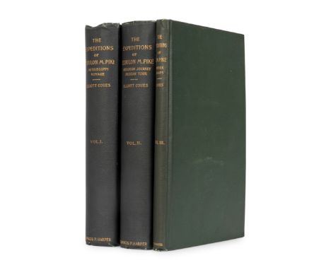
Lot 387
PIKE, Zebulon Montgomery (1779-1813). Elliott Coues, editor. The Expeditions of Zebulon Montgomery Pike, To Headwaters of the Mississippi River Through Louisiana Territory, and in New Spain, During the Years 1805-6-7. New York: Francis P. Harper, 1895.3 volumes, 8vo. Portrait frontispiece in vol.I, folding facsimile letter, 7 maps (including 6 folding into rear pocket of the Index volume). (Some toning and light chipping to extreme outer margin, maps with a few short tears.) Original green cloth gilt (some minor rubbing).LIMITED EDITION, number 788 of 1150 copies. This new edition was "first reprinted in full from the original of 1810, with copious critical commentary, memoir of Pike, new map and other illustrations, and complete index." (Rittenhouse). Howes P-373; Rittenhouse 467 ( "Scholars have preferred the 1895 edition for its annotations, clarity, and appended documents").Property from the Collection of Robert P. Hunter, Jr. and Barbara Hunter, Alpharetta, Georgia
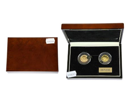
Lot 358
'Operation Fish' 2015 Gold 2-Coin Set, comprising: George V sovereign 1914, obv. bare head left, rev. Pistrucci, AEF, and Canada, Elizabeth II $75 2015, obv. Queen's portrait left, rev. THE ALLIED GOLD L'OR DES ALLIES, maple leaf over map of the North Atlantic, .999 gold, weight 7.81g; limited edition no.67/200, individually encapsulated in display case.

Lot 451
The Ancient Counties of England 1975, a complete set of 40 x silver medallions depicting the historic counties of England (including London as a separate entity), obv. TO COMMEMORATE THE BOUNDARY CHANGES TO THE ANCIENT COUNTIES OF ENGLAND 31ST MARCH 1974, facing lion and Union Jack, rev. various designs featuring landmarks from each county, struck by The Birmingham Mint, hallmarked Birmingham, 1975, .925 silver, diameter 45.2mm, weight circa 40g each (gross weight circa 1600g), in original presentation case with booklet and reproduction map of England by Willem and Johan Blaeu, 1635.


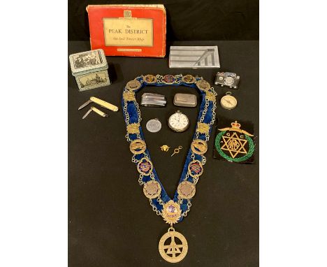
Lot 5180
A Masonic collar with assorted badges, Sussex, Grand Lodge, others; a Buffalo pin and cloth badge; a camera cigarette lighter; a Victorian silver open face pocket watch, Roman numerals, seconds dial, J Pepper Derby retailer's mark, London 1886; pen knives; a pocket compass; a cigarette case; an Ordnance Survey map, The Peak District, on cloth; etc
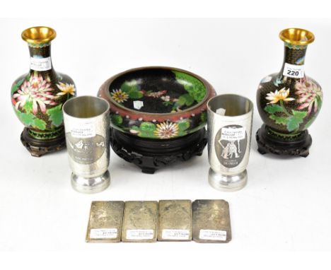
Lot 220
A group of Oriental metalware, two non-matching cloisonné vases, both black ground with multicoloured floral decoration and pink peonies, height of largest 19cm, each with paper label to the base, both with hardwood stands, a black cloisonné bowl with floral decoration of dahlias and abstract design to the rim, red seal mark to base with gold character marks, with hardwood stand, a pair of pewter Indonesian beakers, one with map of Indonesia, the other with image and wording 'Gatutkaca Indonesia', height 14cm, and four Chinese white metal ingots, two with astrological signs to the centre with foliate and scroll design, one with prowling tiger, one with figural design, one with seal mark verso (9).

Lot 680
A 9ct gold charm bracelet with approximately twenty-five gold charms, to include seal fobs, harp, enamelled Chinese lantern, dog, lighthouse, three-masted ship, picture frame, bowl, bells, love heart box which opens to reveal two rings inside, book, horse, Chinese symbol, rugby ball, antelope, articulated fish, Cupid with bow and two hearts, elephant, map of Africa, three coloured dice within pierced orb in swivel mount, etc, united by a 9ct gold heart-shaped padlock clasp, length approx 20cm, approx 136g. CONDITION REPORT Most of the charms are stamped 9ct. The frame is unstamped. The map of Singapore is stamped 14K.

Lot 750
An unusual gold-coloured necklace pendant in the form of a globe, which rotates within a circular frame, possibly French, places on the map are referred to as 'Eurasia', 'Africa', 'Nord America', and 'Sud America', with necklace hoop, unmarked, diameter of circular mount approx 3cm. CONDITION REPORT The pendant is not marked, the vendor purchased it as gold. We are not sure of the core material and are unable to test it. Approx 14g.


-
109182 item(s)/page