We found 109182 price guide item(s) matching your search
There are 109182 lots that match your search criteria. Subscribe now to get instant access to the full price guide service.
Click here to subscribe- List
- Grid
-
109182 item(s)/page


Lot 956
Map engravings - Sanson 'The Kingdom and Desart (sic) of Barca' (Libya), 12.5 x 15 cm; Thomas Kitchen 'Plan of the Port of Genoa' 20 x 11.5 cm (trimmed), two 17th century maps of the Middle East, 15 x 11 cm; Ultoniae Orientalis Pars (Eastern Ireland) 18.5 x 26 cm; Thomas Kitche Mexico of (sic) Nieuw Spanje 1778, 30 x 40 cm (German text) and Samuel Dunn 'Arabia, According to its Modern Divisions', 1774, 33 x 46 cm (7 - unframed)


Lot 933
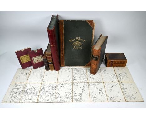
Two Victorian linen-backed folding maps, Ordnance Survey 1866 in slip-cases, East Surrey and Parts of Berkshire, Gloucestershire and Wiltshire to/w a 1912 map of Sunninghill; lot also includes leather-bound vols: Boswell, James, The Life of Samuel Johnson LLD, New Edition, 4 vols bound as 2, London 1819 8vo, half calf; The Journal of the Royal Agricultural Society of England 2nd series vol II 1866, 8vo; The Times Atlas 1895, an unused ledger and an unused 'Letter Book' etc (9)


Lot 928
An 1853 folding pocket street-map of Paris, 'Nouveau Plan de Paris Fortifié', published by Marie et Bernard, 59 x 87 cm to/w a Guilmin pocket guide to Paris with two fold-out maps and guide in English, lot also includes two books of academic and general instruction (French and American); The Kitchen Garden by Sebastian Delamer 1862 16mo; Thorough Guides South Devon and South Cornwall with fold-out maps, 1908; Aristotle's Works containing....Directions for Midwives (c 1850) etc


Lot 1875
A VISITORS' MAP OF FLORENCE; a folding double sided street map with advertisements to the border, 43 x 63cm, now framed and glazed.Additional InformationThere are a couple of small holes noticeably to the main centre of the image where it has been folded, crease marks throughout, colour slightly faded.
Lot 1876
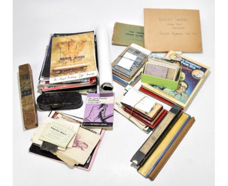
A collection of late Victorian and later ephemera, including various maps including map of bus & tram routes with details of services, Ordnance Survey maps including City of Salford streets, also City of Salford streets atlas, with various motoring books, including MG1100 Driver's Handbook, a motorist record book, also further ephemera including Royal Family photographs, various postcards, etc.


Lot 2156
AFRICAE PROPRIAE TABULA; a 17th century Kerman engraved map, with hand coloured detailing, 40.5 x 52cm, with a Mercator hand coloured engraved map of North West Africa, an Eman Bowen map of Barbary, with thirteen other 18th and 19th century maps and three reproduction maps, all unframed (18). Additional InformationAll of the maps with some edge wear, some with original fold lines and others with some creases.


Lot 2157
UNGARIAE LOCA PRAECIPA RECENS EMENDATA ATQUE EDITA PER JOANNEM SAMBUCUM; a 16th century Ortelius engraved map, with hand coloured detailing, 41.5 x 53cm, unframed. Additional InformationToning and some discolouration at the edge. Three tabs to the middle crease. Small tear at right edge just touching the plate line. Some brown marks to the back.

Lot 2158
THE CONTINUATION OF THE ROAD FROM YORK TO WEST-CHESTER; a 17th century John Ogilby engraved map, with hand coloured detailing, 38.5 x 47.5cm, with a similar road map of Shrewsbury to Holywell and Tinmouth to Carlisle, and a fragment of Ogilby's Road Atlas, p239-246, all unframed (3). Additional InformationThe York map lightly grubby, with a fold and old crease down the middle, some edge wear and two small tears to the top edge. The smaller road map browned and with losses to the right edge. The loose pages with general toning.

Lot 2159
THE EASTERN HEMISPHERE; a 19th century John Cary engraved map, dated 1801, with hand coloured detailing, 51.5 x 57.5cm, with a Colton Northern Regions maps is further migrated maps and a facsimile map, all unframed.Additional InformationAll with some browning and toning to the paper. General edge wear, the Cary is lightly grubby and with two small edge tears.


Lot 2162
A NEW MAP OF NORTH WALES; a 19th century Thomas Dix engraved map with hand coloured detailing, dated 1820, 59 x 82cm, with a John Cary map of North Wales, both unframed (2).Additional InformationThe Dix with some light edge toning and lightly grubby, the Cary with similar but a tear at the central fold at the bottom.


Lot 5063
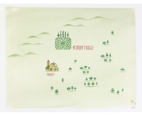
Seven map illustrations by .Paul Birkbeck 1939-2019, Battle 33 x 38 cms,, The British Isles, 44 x 40 cms., Avebury, 30 x 34 cms., Kirby Hall, 30 x 35 cms., Maiden Castle, 29 x 37 cms., Cosmeston, 27 x 34 cms., and Killhope, 30 x 38 cms (7) ABOUT PAUL BIRKBECK; an appreciation, written by one of his daughters and published in the Guardian following his death. "My father, Paul Birkbeck, who has died aged 80, was an artist and illustrator whose work is familiar to those of a certain generation brought up on BBC childrens TV programmes such as Crystal Tipps and Alistair, Play School and Jackanory. His distinctive style and keen eye for detail ensured that he became one of the BBCs most-used artists through the 1970s and 80s. Born in Woolwich, south-east London, Paul attended Brighton College and Epsom School ofArt. After completing his national service, he also became the banjo player for the Dedicated Men Jugband, who signed to Pye Records in 1965. The bands single, Boodle Am Shake, did not trouble the charts but Paul soon began designing sleeves for Decca Records. In 1965 working with BBC childrens TV he became a prolific illustrator for its programmes. For Jackanory he illustrated 14 stories, including A Dog So Small (read by Judi Dench) and Peter Pan, (some in this sale), as well as the BBC Sunday afternoon Bible stories series In the Beginning. His work for Jackanory continued for many years. He created the memorable opening titles for The Vikings in 1980, presented by Magnus Magnusson, and the iconic Miss Marple series, starring Joan Hickson. Paul also drew the backgrounds for the ground-breaking TV series Jane, starring Glynis Barber, which mixed cartoon backgrounds with live actors and was based on the 1940s comic strip of the same name. (some in this sale). In 1991, as well as supplying illustrations, he was in front of the camera playing himself each week in the BBCs six-part childrens TV history programme Now Then, an educational show that cleverly brought our ancestors to life. Paul taught illustration at Leicester Polytechnic, Epsom College and the Royal College of Art, but continued to work in TV, including delivering the titles for the Stanley Baxter Show on Channel 4. He branched out into book illustration with Salman Rushdies 1990 childrens fairy tale Haroun and the Sea of Stories, for which his lavish pictures were much lauded, not least by Rushdie. My father spent the latter part of his life on personal commissions. His work appeared at the Keith Chapman Gallery, London, in Royal Academy summer shows and Sunday Times watercolour exhibitions between 2003 and 2008, and in the Mall Galleries Discerning Eye exhibitions. PROVENANCE The artworks in this sale have been consigned by his family. NOTES: The pictures in this sale were prepared in various mediums often used by the artist and often in conjunction with one another, including, pen and ink, crayon, water-colour, gouache, pastel, and oil and acrylic paints on card or on paper. The auctioneers acknowledge the help of his family in cataloguing this collection, and where-ever known each picture has been listed under its broadcast designation. but the vendors do not guarantee that all attributions in this respect are correct. The family do however guarantee that the pictures, both signed and unsigned are the work of Paul Birkbeck. . All sizes are approximate.


Lot 186
1930’s Flight Suit and Helmet by A G Spalding & Brothers Aviation Clothing, fine khaki canvas cloth one piece flight suit with concealed diagonal front zip. Button downed breast map pocket and lower pockets to both legs. Suit is fitted with its original waistbelt. Interior with the original manufacturers label. Remains in excellent overall condition. Accompanied by the matching lightweight flight helmet. (2 items)


Lot 57
Follower of Jan van Huchtenburg Belgrade - Prince Eugene of Savoy directing troops; Aftermath of the battleOil on canvas, a pairThe latter inscribed iMC. / 1717 (on the horse's pack)Each 108.5 x 172cm (42½ x 67½ in.) (2)Provenance:Private collection, South GermanySale, Sotheby's, London, Old Masters, 8 May 2019, lot 126, where purchased by the present ownerThe Siege of Belgrade ended on the 17th August 1717 with the conquest of the fortress of Belgrade and defeat of the Ottomans by Austrian troops under the command of Prince Eugene of Savoy (d.1736) who is depicted in the first picture on a white horse. These views depict the battle from different angles, showing Belgrade at the confluence of the rivers Danube and Sava. The first picture includes two trompe-l'oeil scrolls, one depicting a map, taken from an engraving by Gabriel Bodenehr, the other provides a key to the topography and action. Jan van Huchtenburg was Court painter to Prince Eugene and a similar view of the siege, from a similar raised vantage point is in the Galeria Sabauda, Turin, no.898.
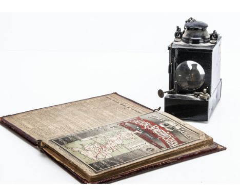
Lot 557
SR Signal Lamp Interior Lantern and L & NWR 1909 Timetables, a tin Welch Patent oil lantern of rectangular form with burner and loop handle glass panels undamaged, stamped SR by Lamp Manufacturing & Railway Supplies Ltd London 21" high and an April 1909 L & NWR volume of time tables published by McCorquodale & Co. With two timetable covers L & NWR and SE & CR map to rear damaged, F-G, (2)

Lot 562
Sir Nigel Gresley 1937 French Railways Free Travel Pass. a folded card pass inscribed Chemins De Fer De Paris a Orleans Carte De Libre Circulation No 9 1937 with hand written detail Sir Nigel Gresley Chief Mechanical Engineer London North Eastern Railway signed by the pass holder, president and director of the French railway network, with embossed stamp and interior printed railway map and printed text on reverse, 4.5" wide. G


Lot 1087
English Copyist, 19th c - St Jerome in the Wilderness, indistinctly signed, oil on board, 29 x 22cm, two watercolours by Joyce Fountain, another of an angler on the banks of the River Avon at Stratford, by E M Miller, a Saxton/Kip map of Nottinghamshire, c1637, hand coloured and a reproduction map (6) As a lot in good condition


Lot 72
A bottle of Sassicaia Tenuta San Guido, vintage 1986. Category: red wine. D.O.C. Bolgheri Sassicaia, Italy. Level: B. 750 ml. Between 1948 and 1967 the wine resulting from this vineyard was consumed privately. It was Mario's son, Nicolò, who began to market the wine with a totally unexpected success. This red put the Tuscan region of Bolgueri on the world map of the best wines, and without having an appellation of origin to protect it. It was so successful with Sassicaia that it was granted an appellation of origin to give prestige to the area. Today, Tenuta San Guido is one of the greatest emblems of Italian winemaking.
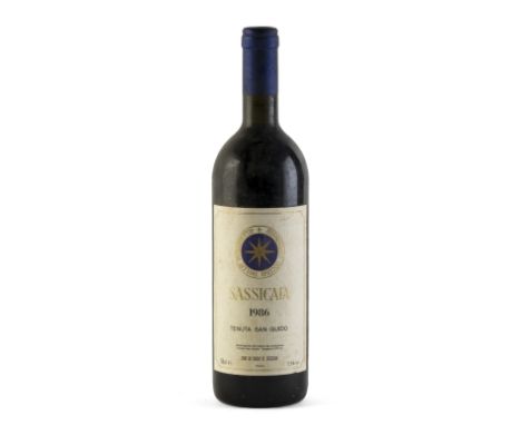
Lot 74
A bottle of Sassicaia Tenuta San Guido, vintage 1986. Category: red wine. D.O.C. Bolgheri Sassicaia, Italy. Level: B. 750 ml. Between 1948 and 1967 the wine resulting from this vineyard was consumed privately. It was Mario's son, Nicolò, who began to market the wine with a totally unexpected success. This red put the Tuscan region of Bolgheri on the world map of the best wines, and without having an appellation of origin to protect it. It was so successful with Sassicaia that it was granted an appellation of origin to give prestige to the area. Today, Tenuta San Guido is one of the greatest emblems of Italian winemaking.


Lot 272
Late 18th century/early 19th century needlework map of England with parts of Ireland and France by Ann Appleton, 41cm max oval, in gilt frame, together with further pieces of 19th century needlework including a mid 19th century tapestry of a pair of lovers, 70 x 58cm in burr wood frame, a biblical scene of Moses in the bull rushes, a firescreen embroidered on silk with vase of flowers within a floral border, etc (6)

Lot 314
A collection of five 18th century engraved maps including Huntingtonshire by Robert Morden, 37 x 43cm approx visible sheet size, Oxfordshire also by Robert Morden, a map of Denmark dated 1789, 50.5 x 56cm approx, further northern European map inscribed Cornelio Pynacker, 38 x 53.5cm, etc, various sizes all frame (5)


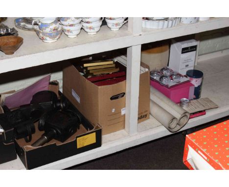
Lot 180
An interesting collection of mainly British topographical subjects and related topics to include At Bath, A Folio of 12 Prints from Drawings by Martin Fisher, Bowles's New Travelling Map with England and Wales, printed for the Proprietor Carington Bowles, Published as the Art Directs January 1789, etc (two shelves)*Please note we have volumes 1-6 of Cassell's History of England (only five photographed)


-
109182 item(s)/page