We found 109182 price guide item(s) matching your search

Refine your search

Year

Filter by Price Range
  • List
  • Grid
  • 109182 item(s)
    /page

Lot 7

Africa.- Speed (John) Africae, described the manners of their habits, and buildings, the first map of Africa prepared by an English cartographer, filled with fictitious mountains, rivers and lakes, with a panel of eight plans illustrating Tanger, Ceuta, Alger, Tunis, Alexandria, Cairo (Alca), Mozambique and the Canaries, and two panels of five figures along the left and right of the map, engraving with hand-colouring on laid paper with indistinct watermark, sheet 410 x 530 mm. (16 1/8 x 20 7/8 in), English text verso, central vertical fold with some carefully repaired splitting, some surface dirt, handling creases, unframed, George Humble, 1626.

Lot 90

Middle East.- Jansson (Jan) Turcicum Imperium, map of the Ottoman Empire showing Cyprus and the Arabian Peninsula, engraving with outline hand-colouring, platemark 415 x 520 mm. (16 1/4 x 20 1/2 in), sheet 480 x 570 mm. (18 7/8 x 22 1/2 in), German text verso, central vertical fold with some repaired splitting, some surface dirt and minor browning, marginal nicks, unframed, [c. 1640].

Lot 15

Africa.- Morocco.- Homann (Johann Christoph) Statuum Marocca Norum, Regnorum Nempe Fessani, Maroccani, Tafiletani et Segelomessani, decorative map of northwestern Morocco, including Canary Islands, with two inset panoramic city views of Morocco (Marrakech) and Mequinetz (Meknes) below, large decorative cartouche with vignette of merchants, soldiers, wild animals, a view of Tangier, and a sea battle, engraving with hand-colouring on laid paper with large watermark, sheet 500 x 580 mm. (19 3/4 x 22 3/4 in), central vertical fold as issued, laid onto thin tissue, with numeorus careful repairs visible when backlit, some small areas of restored loss, handling creases, and minor surface dirt, unframed, Nuremberg, 1728.

Lot 192

Ireland.- Ortelius (Abraham) Eryn. Hiberniae, Britannicae Insulae, Nova Descriptio. Irlandt, the first map of Ireland to include any geographic details, based on Mercator's 1564 wall map of the British Isles and is presented with west oriented to the top, large strapwork cartouche in the upper right corner, engraving with hand-colouring on laid paper with armorial postal-horn watermark, platemark 350 x 475 mm. (13 3/4 x 18 3/4 in), sheet 460 x 560 mm. (18 x 22 in), central vertical fold as issued, handling and printers' creases, minor surface dirt, small marginal nicks to extremities, unframed, [circa 1590].Literature:VdB 22

Lot 69

China.- Bellin (Jacques Nicolas) L'Empire de la Chine pour Servir a l'Histoire Generale des Voyages, map of China and Korea, with Canton, Nanking, and Taiwan described, title cartouche featuring flowers and wind heads with dragonfly wings in the lower right corner, engraving with hand-colouring on laid paper with indistinct circular watermark, platemark 305 x 420 mm. (12 x 16 1/2 in), sheet 315 x 465 mm. (12 1/4 x 18 1/4 in), folds as issued with some handling creases, minor surface dirt, unframed, 1748.

Lot 206

England & Wales.- Smith (Charles) Smith's New Map of the Inland Navigation of England & Wales, with details of the inland waterways, or rivers and canals, of England and Wales, engraving with original hand-colouring, 645 x 540 mm. (25 1/2 x 21 1/4 in), dissected and mounted on linen, some folds cracking with minor splits, minor surface dirt and light browning, folding into original slipacse with printer's engraved label to upper cover, worn, 8vo, 1810.⁂ Scarce.

Lot 108

Middle East.- Directorate of Military Survey, War Office and Air Ministry (D Svy, WO & AM). Persian Gulf, lithographed map printed in colour, sheet 720 x 900 mm. (28 1/4 x 35 1/2 in), some loss to upper edge, handling creases, other marginal nicks and tears to extremities, unframed, 1956.

Lot 59

Asia.- Homann Heirs. Asia Secundum Legitimas Projectionis Stereographicae Regulas et Juxta Recentissimas Observationes..., detailed map of Asia, showing from the Arabian peninsula across India and China, with Indonesia and the Philippines, and Japan in the upper right corner, decorative title cartouche in the lower left corner, further cartouche with scale in the upper right, engraving with hand-colouring, on laid paper with text-based watermark, platemark 500 x 560 mm. (19 3/4 x 22 in), sheet 530 x 610 mm. (20 7/8 x 24 in), central vertical fold with some splitting to lower section, minor nicks and tears, handling creases, some surface dirt and faint marginal damp-stains, unframed, 1744.

Lot 184

British Isles.- Ortelius (Abraham) Angliae, Scotiae, et Hiberniae, sive Britannicar Insularum Descriptio, Ortelius' earliest map of Britain, oriented with north to the right, and embellished with two ornate strapwork cartouches, a royal coat of arms, a compass and scale and five sailing ships, engraving with hand-colouring on laid paper without watermark, platemark 345 x 500 mm. (13 1/2 x 19 3/4 in), sheet 375 x 525 mm. (14 3/4 x 20 3/4 in), Latin text verso, central vertical fold with repaired splitting and reinforced verso, handling creases and surface dirt, repaired marginal tear in the lower right, unframed, [1570].

Lot 151

Italy.- Rome.- Monaldini (Vincenzo, publisher) Pianta della Citta di Roma con la Indicazione di Tutte le Antichita e Nuovi Abbellimenti, large-scale map covering the city of Rome, decorated along the left and right borders with 16 vignettes illustrating St. Peters Basilica, the Pantheon, Colliseum and Forum amongst others, featuring an index of numerous important buildings with key to the map, engraving, 760 x 1130 mm. (30 x 44 1/2 in), dissected and mounted in linen, with some surface dirt and light rubbing, folding into original marbled slipcase with printer's label to upper cover, and later label affixed partially on top, 8vo, 1832; together with Monaldini's Vestigie di Roma Antica, ancient Rome surrounded by plans of classical buildings on fragments of masonry, engraved plan by Acquaroni, 630 x 840mm., dissected and linen-backed, folding into contemporary marbled slipcase, publisher's printed label pasted on with manuscript title and price in French, 8vo, Rome, 1819 (2).

Lot 189

British Isles- Teesdale (Henry) [New British Atlas, Containing a Complete set of County Maps... to year, 1830], 41 maps only (of 48), with title, 3 folding maps of England & Wales, Ireland and Scotland, and 38 single-page county maps, engravings with hand-colouring, each single sheet map approx. 460 x 350 mm. (18 x 13 3/4 in), occasional nicks and tears, some splitting to folds in the 3 folding maps, surface dirt, lacking boards and spine, largely disbound, folio, 1830

Lot 150

Italy.- Sicily.- Anonymous. Carta della Sicilia con l'antica e la moderna divisione in Valli, large detailed folding map of Sicily, including the island of Stromboli in the north and with Malta and Gozo in the south, engraving, a well inked and detailed impression, 940 x 940 mm. (37 x 37 in), dissected and mounted on linen, folding into contemporary marbled slipcase, 8vo, 1818.⁂ Scarce. The Biblioteca della Fondazione scienza e tecnica in Florence holds a copy, but we have been unable to locate any other copies or records at auction.

Lot 104

Middle East.- Mecca.- [Panckoucke (Charles L.F.)] Carte du Golfe d'Arabie, Depuis Suez à Bab-El-Mandeb..., detailed map of the Red Sea, with part of Egypt and the source of the Nile in the upper left, showing tracks of Poncet and James Bruce, and with numerous details along the coast of Saudi Arabia including Jeddah and Mecca, and four inset maps of bays, engraving with hand-colouring, platemark 650 x 515 mm. (25 1/2 x 20 1/4 in), some folds as issued, minor rubbing and surface dirt, framed and under glass, [1791 or slightly later].

Lot 132

France.- French Revolutionary Wars.- Anonymous. A General Map of France Divided into Metropolitan Circles and Departments with the surrounding States, detailed map of France, with parts of Spain, Switzerland, Corsica, Sardinia, and the south of England, decorated with two panels each with four vignette views of battles and sieges from the French Revolutionary Wars, including the 'Evacuation of Toulon' in 1793 to the Battle of Castiglione in 1796, engraving on two sheets joined, total 625 x 1060 mm. (24 1/2 x 41 3/4 in), laid onto linen, with several areas of loss carefully restored, some with facsimile, numerous handling creases, surface dirt, unframed, [c.1798-1802].

Lot 219

London.- Creighton (Robert) A Plan of London and its Environs, showing from Hyde Park to Islington, and Shadwell to Kennington, from Lewis' Topographical Dictionary, engraved map by J. & C. Walker, after Creighton, with full hand-colouring on wove paper, sheet 440 x 530 mm. (17 1/4 x 20 7/8 in), some folds as issued, several with careful repairs to splitting, only visible verso, minor marginal repair to upper right corner, unframed, [c. 1840].

Lot 76

Egypt.- Faden (William) Lower Egypt and the Adjacent Deserts, with a Part of Palestine, fine and detailed map covering the region from Arabs Bay in the west to the delta of the Nile, and into the Holy Land to above Mt. Carmel, and south to below Memphis to Atsieh, Adhroditopolis, and Ellahoun, engraving with hand-colouring, platemark 560 x 760 mm. (22 x 29 7/8 in), central vertical fold as issued, some handling creases, minor surface dirt, framed and under glass, 1802.

Lot 28

Americas.- Zatta (Antonio) Il Canada, le Colonie Inglesi con la Luigiana, e Florida di Nuova Projezione, Revolutionary War map illustrating all of the British colonies, extending to include Nova Scotia, all of the Great Lakes and westward to name Cenis in Texas, showing early forts, Indian lands, watershed and limited topography, engraving with hand-colouring on laid paper with watermark of three crescents, and countermark with initials 'G.F.A.' surmounted by a crown, platemark 315 x 410 mm. (12 1/4 x 16 1/8 in), sheet 380 x 525 mm. (15 x 20 3/4 in), central vertical fold as issued, some handling creases, small puckering to lower edge of sheet, not affecting the map, unframed, Venice, 1778.

Lot 80

Holy Land.- Eastern Mediterranean.- Visscher (Nicolas) Geographische Beschryvinge, van de Wandeling der Apostelen ende de Reysen Pauli..., map extending from Rome, through Asia Minor and the Holy Land, to Babylon, with the route of Apostle Paul charted from Jerusalem to Rome, surrounded with nine vignettes depicting events from Paul's journey, engraving on laid paper without watermark, platemark 320 x 480 mm. (12 x 18 7/8 in), sheet 410 x 520 mm. (16 1/8 x 20 1/2 in), central vertical fold as issued, minor handling creases, unframed, [c. 1650].

Lot 117

India.- Dury (Andrew) An Actual Survey of the Provinces of Bengal, Bahar &c., By Major James Rennell [...] published from a drawing by A. Dury, large two-sheet wall map of Bengal, illustrating the course of the Ganges River from Varanasi (Benares) eastward to the Ganges Delta and the Bay of Bengal, including Varanasi (Benares), Dacca (Dahka, Bengladesh), and Patna among many other important Indian cities, with the foothills of the Himalayan Mountains and the border with Bhutan to the north, engravings with outline hand-colouring, four sheets joined as two, each sheet approx. 540 x 1480 mm. (21 1/4 x 58 1/4 in), folds as issued, some handling creases, surface dirt, and minor nicks and tears, unframed, Laurie & Whittle, 1794.

Lot 4

World.- Stoopendaal (Daniel) Werelt Caert, double-hemisphere world map from a Dutch bible is based on Visscher's similar map of 1663, showing California as an island with a flat northern coastline, and with diagrams of the Copernican and Ptolemaic solar systems in between the hemispheres and illustrations of various animals and people in regional dress, engraving on laid paper without watermark, sheet 315 x 460 mm. (12 1/4 x 18 1/8 in), Dutch text verso, central vertical fold as issued with small stitch-mark holes, trimmed to borderline with some nicks and small tears to extremities, otherwise handling creases, unframed, [1688].

Lot 19

Africa.- Military maps.- Militair Geografisch Instituut. Brussel. Belgisch Congo, large-scale four sheet map, lithographs printed in colour, each sheet approx. 850 x 720 mm. (33 1/2 x 28 1/4 in), handling creases, minor nicks and tears, unframed, [c. 1930-1950] (4).

Lot 20

South Africa.- Jansson (Jan) Aethiopia Inferior, vel Exterior, map of South Africa covering the region from Congo-Zanzibar to the Cape, decorative title cartouche with an animal skin held aloft by two African men, engraving with outline hand-colouring on laid paper without visible watermark, platemark 385 x 500 mm. (15 1/4 x 19 3/4 in), sheet 455 x 565 mm. (17 7/8 x 22 1/4 in), Dutch text verso, central vertical fold as issued with marginal repair to upper section, some browning and spotting, marginal repaired tear to centre right, unframed, [c. 1640].

Lot 207

NO RESERVE England.- Wallis's New Pocket Edition of the English Counties or Travellers Companion, engraved throughout with title, contents, general map and 43 hand-coloured engraved maps including Isle of Wight, one double-page, one becoming loose, in signature to head of title and front endpaper contemporary half roan, roan label to upper cover, rubbed, 12mo, J.Wallis, [c.1810].

Lot 225

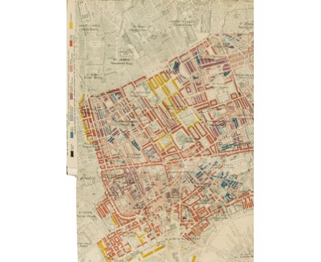
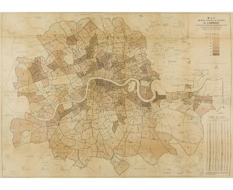
London.- Booth (Charles) Life and Labour of the People in London, 16 vol. only (of 18), including vol. 1, 3, and 4 from the 'First Series', 1904 reprint of 1902 edition, vol. 1-5 from the 'Second Series', 1903, vol. 1-7 from the 'Third Series', 1902, and the 'Final Commentary' vol., 1902, with 20 folding maps of London tipped-in to the Third Series volumes, lettered 'A' to 'U', albeit lacking 'I', presumably as published, lacking supplementary maps, the folding maps are based on Stanford's Library Map of London and Suburbs at a scale of 6 inches to 1 mile, lithographs with original hand-colouring, mounted on linen, each with original key tab, various sizes, some occasional minor handling creases, numerous library stamps, ink numbers, and book plates, mainly to titles, bound in original vellum lettered and decorated in gilt, library number in gilt to upper cover of some, rubbed and soiled, worn, Macmillan and Co., [1902-1904] (16); sold not subject to returnProvenance:Ex libris of Fulham Public Libraries ⁂ The folding maps included are as follows:Map A - Isle of DogsMap B - Outer East LondonMap C - HackneyMap D - North LondonMap E - Inner North WestMap F - Lisson GroveMap G - Hampstead & St Johns WoodMap H - Inner East LondonMap J - East Central LondonMap K - West Central LondonMap L - Westminster & PimlicoMap M - The Inner WestMap N - The Outer WestMap O - FulhamMap P - Inner South LondonMap Q - Deptford and GreenwichMap R - WoolwichMap S - BatterseaMap T - WandsworthMap U - Outer South London

Lot 56

Asia.- Southeast Asia.- Spice Islands.- Jansson (Jan) Insularum Moluccarum Nova Descriptio, map of the Spice Islands, the cornerstone of the Dutch trading empire in the East Indies throughout the 17th Century, with decorative title cartouche supported by two sea monsters, and further embellished with various sailing vessels, sea monsters, two elaborate compass roses and a native couple displaying the costumes and weapons of the region, engraving with early hand-colouring on laid paper, platemark 395 x 505 mm. (15 1/2 x 19 7/8 in), sheet 490 x 590 mm. (19 1/4 x 23 1/4 in), French text verso, even toning to the sheet, some damage to the lower right quadrant just below the two figures, some spotting and surface dirt, unframed, [circa 1640].

Lot 142

Switzerland.- Mallet (Henri) Partie occidentale et méridionale de la Suisse et Païs de Vallais, map showing the Haute-Savoie, part of southern Switzerland, the canton of Valais, with Geneva and Lac Leman to the centre right, with numerous topographical details of the region's mountains, including glaciers, engraving with hand-colouring, dissected into 18 sections and laid onto wove paper as one, total sheet 545 x 780 mm. (21 1/2 x 30 3/4 in), some additional pen facsimile map in the lower left margin, handling creases, surface dirt, nicks and tears, with small marginal loss to upper left corner, unframed, Geneva, F. Monty, [1818].

Lot 1

Ancient World.- Münster (Sebastian) Altera Generalis Tab. Secundum Ptol., clouds and eight named wind heads surround a map illustrating the conception of world geography prior to the discovery of the New World and according to Claudius Ptolemy, second edition with the fine vertical crack line across the right-hand part of the map, woodcut on laid paper, sheet 310 x 390 mm. (12 1/4 x 15 1/4 in), Latin text verso, central vertical fold as issued with minor marginal nicks, otherwise very faint marginal damp-stains and surface dirt, unframed, [c. 1545-50].

Lot 174

Atlases.- de Laporte (L'abbé Joseph) Atlas ou Collection de Cartes Géographiques pour l'Intelligence du Voyageur Francois, title, 26 double-page maps, including a double-hemisphere world map, and others of the Americas, Virginia & Maryland, China, India, and Mexico, bound with an additional folding map of France, contemporary boards, lacking spine, very rubbed and worn, large 8vo, Paris, Moutard, 1787.

Lot 120

India.- Thomson (John) British India, Southern Part; British India, Northern Part; Hindoostan, three maps of India from Thomson's New General Atlas, the first two mentioned forming a two-sheet map of India, numerous inset maps, all with high level of detail, engravings with hand-colouring on wove paper, the first two sheets each approx. 530 x 680 mm. (20 3/4 x 26 3/4 in), the latter 530 x 735 mm. (20 3/4 x 28 7/8 in), some surface dirt and browning, a few nicks and tears, unframed, [c. 1815-1820], (3).

Lot 43

Caribbean.- Battle of St. Lucia.- Faden (William) Sketch of Part of the Island of Ste. Lucie, map by Lt. G.V. Hart, assistant engineer while in North America, showing the northwestern coast of Saint Lucia, specifically Grande Cul De Sac Bay to Castries, with details of British troops and fleets, and a letterpress extract from General Grant's Letter to Lord Germain printed below the map, engraving and letterpress on laid paper with large watermark of Strasbourg lily, map 405 x 495 mm. (16 x 19 in), sheet 570 x 750 mm. (22 1/2 x 29 1/2 in), damp-stain and browning to the sheet, one small hole and abrasion, unframed, 1781.⁂ The Battle of the Cul de Sac was a naval battle fought between the British Royal Navy and the French Navy, off the island of St. Lucia during the American Revolutionary War on 15 December 1778. Following the battle the island eventually surrendered to the British.

Lot 124

Europe.- Traux (Maximilian de) Carte Generale et Itineraire de L'Europe Divisee en tous ses Etats apres Le Congres de Vienne, large folding map of Europe, with large calligraphic title in the upper left corner, engraving with some outline hand-colouring, 1390 x 1710 mm. (54 3/4 x 67 1/4 in), dissected and mounted on linen, some scattered spotting and surface dirt, some scuffs and areas of abrasion, with some panels peeling at edges from linen, folding with publisher's printed label to upper cover, without slip-case, 8vo, Vienna, 1827.

Lot 118

India.- Dury (Andrew) A Map of the Provinces of Delhi, Agrah, Oude, and Ellahabad, comprehending the Countries lying between Delhi, and the Bengal-Provinces, Surveyed by James Rennell, large two-sheet wall map of Delhi and Bengal, illustrating the Ganges River from the foothills of the Himalayas, to just outside Patna, engravings with outline hand-colouring, four sheets joined as two, each sheet approx. 540 x 1480 mm. (21 1/4 x 58 1/4 in), folds as issued, some offsetting, surface dirt, and minor nicks, unframed, Laurie & Whittle, 1794.

Lot 224

London Poverty.- Booth (Charles) Map Shewing Degrees of Poverty in London in areas with about 30,000 Inhabitants in each, Compiled from Information Collected in 1889-1890, detailed map dividing the city into areas with colour-coded key illustrating the extent of poverty in each location, based on Stanford's 'Library map of London', with key and table in the upper and lower right corners, respectively, originally published with the appendix to 'Labour & Life of the People' vol. 2, lithograph printed in colour, sheet 660 x 895 mm. (26 x 25 1/8 in), laid onto linen, some handling creases and light folds, small areas of of loss carefully restored, minor surface dirtr, unframed, [1890-1891].

Lot 164

Spain & Portugal.- Ortelius (Abraham) Regni Hispaniae Post Omnium Editiones Locuplessima Descriptio, first state map of the Iberian peninsula surrounded by stipple engraved seas, with ships and sea monsters, large strapwork title cartouche and scale of miles with a divider in the lower corners, engraving with hand-colouring on laid paper with armorial watermark, platemark 380 x 490 mm. (15 x 19 1/4 in), sheet 420 x 525 mm. (16 1/2 x 20 3/4 in), Latin text on verso, central vertical fold as issued, reinforced verso, some minor handling creases, unframed, [1571]Literature:VdB 25

Lot 45

Caribbean.- Stockdale (John) A Map of the Island of St. Domingo, detailed map of Hispaniola, Saint Domingue or present-day Haiti and Dominican Republic, engraving with hand-colouring on wove paper, sheet 520 x 770 mm. (20 1/2 x 30 1/4 in), folds as issued, some faint signs of water damage, minor browning and surface dirt, unframed, [1806].

Lot 228

London Underground.- [Beck (Henry C., "Harry")] [Map of London's Underground Railways], Edition No. 2 1936, diagrammatic underground tube map with 'Interchange Stations Central Area' listed verso, colour-printed map, sheet 150 x 230 mm. (5 7/8 x 9 in), two vertical folds as issued, minor rubbing, unframed, Johnson, Riddle & Co. Ltd. for London Transport, 1936

Lot 79

Holy Land.- Middle East.- Ortelius (Abraham) Geographia Sacra, map of the ancient Biblical world including southern Europe, northern Africa and the Middle East, with inset map of the world in the lower centre, a strapwork cartouche to the left and right, and with decorative title cartouche upper centre, engraving with hand-colouring on laid paper without watermark, platemark 360 x 480 mm. (14 1/4 x 18 7/8 in), sheet 450 x 560 mm. (17 3/4 x 22 in), blank verso, central vertical fold as issued, small repair in the lower right, surface dirt, minor handling creases with small nicks to extremities, unframed, [c. 1603-1612].Literature:VdB 179

Lot 200

Scotland.- Jansson (Jan) Scotia Regnum, detailed map of Scotland including the Hebrides, with an inset map of the Orkney Islands in the upper right corner, title cartouche surmounted by the arms of Scotland and royal coat of arms of James VI above, engraving with hand-colouring on laid paper without watermark, sheet 400 x 520 mm. (15 3/4 x 20 1/2 in), central vertical fold as issued, with minor repaired splitting to lower section, small nicks to extremities, faint spotting and surface dirt, unframed, [c. 1638].

Lot 85

Holy Land.- Homann (Johann Baptist) Carte de la Terre Sainte Divisee selon les Douze Tribus d'Israel ..., detailed map revised by Christoph Harenberg of modern-day Israel, Jordan and Palestine, showing the Holy Land divided into twelve regions according to the territories allotted for each of the twelve tribes, with an inset of map of the region showing Roman historical divisions, and a large decorative cartouche in the lower right corner, engraving with early hand-colouring, 490 x 560 mm. (19 1/4 x 22 in), sheet 515 x 610 mm. (20 1/4 x 24 in), central vertical fold as issued, with old repairs to splitting at upper and lower sections, repaired tear to lower left edge, minor handling creases, even browning, unframed, 1750.

Lot 181

Atlases.- British Isles.- Laurie (Richard H., publisher) Laurie's New Traveller's Companion and Guide through the Roads of England and Wales, including Great part of Scotland; with a General Map, and an Index Villaris, &c., title, 8 pp. index, folding map of England, Wales, and part of Scotland, and with 25 double-page linear road maps, engravings with hand-colouring, on wove paper, some sheets watermarked 'J & M Mills 1825', some minor offsetting and light spotting, small area of loss to margin of map of England, Wales and part of Scotland, limp blue calf, worn, 4to, 1828.

Lot 73

Egypt.- Homann (Johann Baptist) Aegyptus Hodierna. Ex itinerario Celeberrimi viri Pauli Lucae, Franci desumta ac novissime repraesentata, map of Egypt focused on the Nile River Valley from the Mediterranean to below the First Cataract at the confluence of the White and Blue Nile, with large scenes of the cataracts, the Sphinx, pyramids, and other various antiquities to the lower left, engraving with hand-colouring, platemark 580 x 475 mm. (22 3/4 x 18 3/4 in), under glass, minor handling creases, some surface dirt and light browning, framed and under glass, [c. 1720].

Lot 183

British Isles.- Ruscelli (Girolamo) Tabula Europae I, map of the British Isles on a trapezoidal projection, based on Claudius Ptolemy, engraving on laid paper with partial watermark, sheet 210 x 280 mm. (8 1/4 x 11 in), Latin text verso, central vertical fold, unframed, [c. 1560].

Lot 178

Atlases.- Letts, Son & Co. (Publishers) Letts's Popular County Atlas. Being a Complete Series of Maps Delineating the Whole Surface of England and Wales, title, 47 double-page maps, including key map, lithographs printed in colours, each map approx. 355 x 425 mm. (14 x 16 3/4 in), occasional spotting and foxing, minor surface dirt, later cloth, worn, large 4to, Mason & Payne, 1887.

Lot 60

Asia.- d'Anville (Jean Baptiste Bourguignon) Seconde Partie de la Carte d'Asie Contenant la Chine et Partie de la Tartarie, l'Inde au dela du Gange, les Isles Sumatra, Java, Borneo, Moluques, Philippines, et du Japon, large detailed two-sheet map of eastern Asia, including China, Korea, Japan, and Southeast Asia, engraving with outline hand-colouring, each sheet approx. 580 x 725 mm. (22 3/4 x 28 1/2 in), each with central vertical folds as issued, minor surface dirt and spotting, the lower sheet with marginal loss, otherwise minor nicks, unframed, Paris, 1752.

Lot 27

Americas.- Dunn (Samuel) America North and South; with the Atlantic and Pacific Oceans; wherein are distinguished all the New Discoveries, map of the Western Hemisphere and most of the Pacific, with much still undiscovered, with description in the Pacific of "Signs of Land," and "Land descry'd by Mendaña in 1568", with New Zealand, "as mapped by Cook", engraving with some outline hand-colouring, platemark 330 x 460 mm. (13 x 18 1/8 in), sheet 470 x 570 mm. (18 1/2 x 22 1/2 in), central vertical fold, with some splitting to lower section, minor surface dirt and light browning and offsetting, unframed, Robert Sayer, 1774.

Lot 199

Scotland.- Cary (John) A New Map of Scotland from the latest authorities, large four sheet map of Scotland, not joined, with inset maps of the Shetlands and Orkney, engravings with hand-colouring, each platemark approx. 510 x 595 mm. (20 x 23 1/2 in), sheets each approx. 550 x 655 mm. (21 3/4 x 25 5/8 in), each sheet with damp-stain to one lower corner, largely marginal, some handling creases, unframed, 1801 (4).

Lot 58

Asia.- Seutter (Matthäus) Asia cum omnibus Imperiis, Provinciis, Statibus et Insulis..., map of Asia, showing eastern Europe, Scandinavia, Egypt and the northern tips of Australia, title cartouche of costume figures, lion, elephant and horse, lower left, dedication cartouche with allegorical figures of the four elements, upper right, engraved map with hand-colouring, platemark 500 x 580 mm. (19 3/4 x 22 3/4 in), sheet 535 x 605 mm. (21 x 23 7/8 in), central vertical fold as issued, reinforced verso, some handling and printers' creases, faint marginal damp-stains in lower section, unframed, Augsburg, [c. 1730].

Lot 14

Africa.- Lizars (Daniel) Africa, map of Southern Africa, showing from Gabon to South Africa, including Madagascar and outlying islands, engraving with some outline hand-colouring on wove paper without watermark, sheet 430 x 900 mm. (17 x 35 1/2 in), pencil inscription below title indicating scale of map, two vertical folds as issued, other minor handling creases, marginal nicks and tears, some surface dirt, unframed, [c. 1820].

Lot 17

NO RESERVE Africa.- Silk map.- Anonymous. Somaliland [recto]; Kenya Colony & Juba River [verso], double-sided military map, lithograph printed on silk, 470 x 560 mm. (18 1/2 x 22 in), folds and handling creases, unframed, [1940s]; together with 5 other maps of Africa and others, including Samuel Bagster's 1809 map of Africa, various sizes, (6).

Lot 121

India & South East Asia.- Lapie (Pierre) Carte de L'Inde en deçà et au delà du Gange, detailed map extending from India in the west to Vietnam and the Malay Peninsula in the east, engraving with outline hand-colouring on laid paper, sheet 505 x 640 mm. (19 3/4 x 25 1/4 in), central vertical fold as issued, minor spotting and surface dirt, unframed, Paris, Fruger & Cie., 1829; together with Rapkin's map of Asia, 280 x 350 mm. (11 x 13 3/4 in), unframed (2)

Lot 99

Turkey.- Homann Heirs. Carte de l'Asie Mineure ou de la Natolie et du Pont Euxin ..., detailed map of Turkey by J.M. Haas, with parts of Greece, Cyprus, and the northern coast of the Black Sea, title also in Latin in the upper section, with decorative vignettes surrounding scales and text in the upper left corner, engraving with hand-colouring, platemark 505 x 590 mm. (19 7/8 x 23 1/4 in), small margins, central vertical fold as issued, even browning and surface dirt, framed and under glass, 1743.

Lot 36

NO RESERVE Americas.- South America.- [Dalton (Leonard V.)] Map of The United States of Venezuela, including the results of the latest surveys, lithograph, 685 x 805 mm. (27 x 31 3/4 in), folding, with some minor splitting, unframed, Johnson Riddle & Co., [1923]; together with The Eastern Andes of Central Peru by J.V. Harrison, lithograph, 240 x 370 mm. (9 1/2 x 14 1/2 in), Royal Geographical Society, 1945 (2).

Lot 13

Africa.- De L'Isle (Guillaume) Carte de la Barbarie de la Nigritie et de la Guinée, map of western Africa from Barbary, Nigeria, and Guinea to below the equator, with numerous tent encampments depicted throughout the Sahara Desert, engraving with outline hand-colouring on laid paper without watermark, platemark 510 x 625 mm. (20 x 24 1/2 in), sheet 540 x 640 mm. (21 1/4 x 25 1/4 in), central vertical fold as issued, minor handling creases, unframed, Covens & Mortier, [c. 1730].

Lot 50

Saint Helena.- Read (Lieut. R.P.) Geographical Plan of The Island & Forts of Saint Helena, the island orientated with north to the lower left corner, with Napoleon's residence incorrectly identified at Plantation House in the centre of the island, with facsimiles of Napoleon's signatures in the lower right corner, engraved map by Kirkwood, with early hand-colouring, 455 x 600 mm. (17 7/8 x 23 5/8 in), dissected and mounted on linen, with descriptive engraved text verso, folding into contemporary slip-case with title and vignette printed on orange paper, rubbed and worn, 8vo, Burgis & Barefoot and others, October 1815.

Lot 102

Middle East.- Seale (Richard William) Arabia, fine map centered on Arabia, showing Jirja and Alexandria in Egypt, and to the east are Iraq and part of Persia, with Baghdad, Basra and Shiraz, Cabara and Tul, all of the Red Sea, the Persian Gulf and the Bay of Ormuz, with inset "The Temple of Mecca, as it was formerly; from a Draught in the Bodleian Library", engraving on laid paper without watermark, platemark 340 x 390 mm. (13 3/8 x 15 1/4 in), sheet 365 x 470 mm. (14 3/8 x 18 1/2 in), folds as issued, with some splitting to the central horizontal fold at left edge, small tear in the centre right, otherwise some light browning and offsetting, minor surface dirt, unframed, [1764].

Lot 218

London.- Cruchley (George Frederick) Cruchley's New Plan of London Improved to 1832, the largest of the three of issues of this map of London, showing from Hoxton to the East India Docks, Walworth, and Hammersmith, with decorative border and inset title to upper section, engraving with original hand-colouring, the printed border separately printed and affixed onto map, size of map excluding border 435 x 1280 mm. (17 x 50 1/4 in), an additional 45 mm. is added with extension to Hammersmith in the lower left as issued, dissected and mounted on linen, some areas of abrasion and surface loss, notably to the title and upper edge, some surface dirt, folding with original green marbled ends, publisher's printed labels to each, with original green marbled slip-case, publisher's printed label to upper cover, very rubbed and worn with splits and loss, 8vo, 1832.Literature:Howgego 304 C (1)

Lot 235

NO RESERVE Cornwall.- Morden (Robert) Cornwall, engraving with some hand-colouring, sheet 380 x 425 mm. (15 x 16 3/4 in), framed and glazed, [c. 1695]; together with Saxton/Hole map of Herefordshire, and a Yorkshire distance chart, all framed and glazed, [17th century] (3).

Lot 177

Atlases.- SDUK (Society for the Diffusion of Useful Knowledge) [The Family Atlas], 71 maps only, including Sir Roderick Murchison's Geological map of England and Wales, 5 celestial charts, and 3 folding maps, engravings with hand-colouring, each sheet approx. 450 x 370 mm. (17 3/4 x 14 1/2 in), loose, nicks and tears to some extremities, handling creases, minor surface dirt, lacking spine, upper and lower boards detached, folio, Thomas Letts, 1876.

Lot 113

India.- Homann Heirs. Citra Gangem hoc est Orae Celeberrimae Malabar & Coromandel cum Adjacente Insula non Minus Celebratissima Ceylon..., map of the southern part of India and Sri Lanka, with colonial possessions and trading posts delineated with flags along the coastline, decorative title cartouche with elephant in the lower left corner, engraving with hand-colouring on laid paper with cross-based watermark, platemark 570 x 505 mm. (22 1/2 x 19 7/8 in), sheet 610 x 535 mm. (24 x 21 in), central horizontal fold as issued, minor even browning and surface dirt, unframed, 1733.

Lot 212

London and Brighton.- Edwards (J.) Edwards's General Map of 1400 Square Miles, map of the road from London to Brighton, East Surrey and East Sussex, with north oriented to the left, engraving with hand-colouring on wove paper with watermark of initials 'E. P.', platemark 290 x 595 mm. (11 1/2 x 23 1/2 in), sheet 330 x 620 mm. (13 x 24 3/8 in), some spotting and surface dirt, unframed, 1800.

Loading...Loading...
  • 109182 item(s)
    /page

Recently Viewed Lots