We found 109198 price guide item(s) matching your search
There are 109198 lots that match your search criteria. Subscribe now to get instant access to the full price guide service.
Click here to subscribe- List
- Grid
-
109198 item(s)/page


Lot 1021
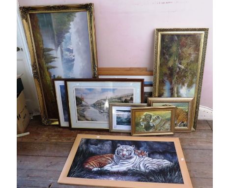
Large collection of paintings and prints to includeLarge oil on canvas of a Swiss chalet by a lake with mountains , 73cm x 136cmLarge oil on canvas woodland and river scene , signed lower left 51cm x 111cmLimited edition print , "Steam at top shed " by David Weston , signed and numbered 133/50061.5cm x 83cmPrint of the maiden voyage of the Britannia 1896 . 62cm x 86cm2 limited edition signed prints of tigers . White Water by Stephen Gayford , number 132/1100 36cm x 42cm . And Siberian Tigers by Paul James , number 67/850 , 52cm x 74cmA group of 5 prints of tigers , to include 2 limited edition prints by Stephen Gayford largest 61cm x 112cm2 signed water colours of boat scenes and 5 prints including a print of BathA group of 15 prints to include a map of the Official New York City subway and a Bradford Exchange limited edition of Lamplight lane

Lot 145
MONTEGRAPPA FOUNTAIN PEN, CLASSICAL GREECE LIMITED EDITION.Barrel in blue resin and sterling silver.Two-tone 18 kts gold nib, M-point.Limited edition.No box.Measurements: 15 cm. length; 18,34 mm. diameter.Montegrappa pays homage to Greece, its glorious past and its culture with a Limited Edition whose shape recalls the Olympic torch and the sharp lines of the Greek columns. The "Classical Greece" has a turquoise body of the finest celluloid with a precious metal cap. It is enhanced with a miniature of an ancient map of the Peloponnese hand-drawn on the end-cap by the application of precious baked enamels. This remarkable technique is practised by very few artists in the world, true masters who are able to create such pieces. These magnificent creations were launched during the 2004 Olympic Games in Athens, Greece. The nib, two-coloured, made of 18 Kts gold, with M tip.


Lot 743
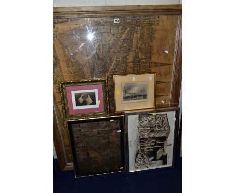
SIX ASSSORTED PICTURES, comprising a mixed media depiction of coal miners at 'The Alamo' Cortonwood Colliery by Vincent Feeney 1987, approximate size 37cm x 49cm, a depiction of Lichfield Cathedral circa 13th Century surrounded by castle walls, approximate size including frame 98cm x 120cm, Stratford upon Avon print, Reproduction map of Cumberland, framed postcard of a dog 'Edgemore Etonian' and topographical print 'The walls of Southampton' (6)

Lot 130
A SILVER MAP OF GREAT BRITAIN, etched with the boundary lines and coats of arms of the historic counties, embellished with 24 carat gold, a limited edition number 1560, authorised and issued by the Council for the Protection of Rural England, hallmarked 'Danbury Mint' London 1978, dispalyed in a dark brown wooden frame with black felt detailing, approximate frame dimensions width 522mm x length 691mm, together with a speperate framed certificate of authenticity, (condition report: general moderate wear, minor damage to frame)

Lot 730
FOUR BOXES AND LOOSE, to include a brown ladies sheepskin jacket ( small tear on lefthand shoulder), a 1950's Lines Bros. push along dog on wheels, a carved musical fruit dish, Telemax binoculars, a set of grocer's shop scales with a white ceramic pan, two modern porcelain dolls, a framed map of Herefordshire (September 1741), a Eumig P8 automatic cine film camera with six film reels, two modern stainless steel flasks, a Russell Hobbs bread maker, a German cigarette card collectors book of birds (xmas 1945 appears to have whole collection of cards ), framed print, etc(4 boxes + loose)
Lot 806
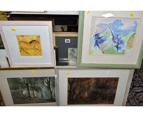
PAINTINGS AND PRINTS ETC, comprising Ronald John Margetts (1924) 'Red Wood' an abstract study of woodland, signed bottom right, artist label verso, approximate size 26cm x 38cm, an abstract study attributed to Anthony Baynes (1921-2003) bears initials bottom left, a woodland watercolour 'Sussex Wood' no visible signature but bears a torn artist label verso with the name John P???, a mixed media African landscape 'Amboselli, Kenya', signed E Bostock, a mixed media sketch of a cave painting horse by Jilly Cobbe, a limited edition print after William Russell Flint 'Artemis and Chione' 166/850 published 1981 and an Ole West print 'Wegetonne' a shipping beacon against a maritime map (7)


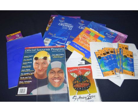
Lot 111
Various ephemera from the sydney Olympic games 2000 to include, Closing Ceremony ticket x 1; Closing Ceremony Programme, Closing Ceremony blowfly barbecue sticker, 14 other tickets for Athletics, diving, cycling mountain bike, beach volleyball, archery, taekwondo, hockey, gymnastics etc, Official Souvenir programme x 1, Official Spectator Guide x 1; Sunday Mail Event list and ticket order, Road cycling information leaflet (official) 2 pages includes a map, Sydney Olympic park leaflet 2 pages (from event), Olympic Remaining tickets brochure from late 1999, Programmes official daily – Day 7, 8, 10

Lot 115
Vairous ephemera from the Barcelona 92 Olympic Games to include, Olympic Opening Ceremony tickets x 2, Olympic Closing Ceremony tickets x 2, Opening ceremony programme x1, Official Souvenir Programme x 3, Barcelona Guide Timeout magazine, Olympic Glory Magazine, Brochure Sant Sadurni d’Anoia, Brochure Piscines Bernat Picornell, Barcelona City Map, Barcelona 92 daily newspaper 15, 13, 10, Sticker (Freedom for Catalonia) Fan from Ricoh (sponsor), Various sports tickets (mainly 2 of each) – 36 total: includes Badminton, Swimming, Athletics, Cycling (track) etc.

Lot 109
Suvoniers and ephemera from the Olympic games Atlanta 1996 to include, Radio times 20-26 July 1996, Programmes, Olympics 96 Official Guide to Atlanta x1,Tickets 18 (mainly athletics), Action Ball Point Pens set of 3, Official Map x 1, Official Spectator guide x1, Spirit of Olympics licensed memorabilia brochure; The centanial Games programme, Atlanta guide to the 1996 olympic games
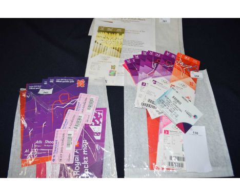
Lot 110
Vairous ephemera from the London 2012 Olympic games to include, Spectator guides for Athletics, football (Coventry), taekwondo, volleyball, The Royal Artillery Barracks Map, Shooting. Closing Ceremony tickets x 2, Closing Ceremony leaflet Symphony of British Music, Ticketx1 – waterpolo pre Olympic event, Ticketx1 – football x4 (Coventry), Tickets various x – gymnastics (4), gymnastics rhythmic (1), volleyball (1), Athletics (6), taekwondo (2), shooting (1), cycling mountain bike (1)

Lot 40
Großes Konvolut Kupferstichlandkarten aus dem deutschen Raum, 18./19.Jh. - Karten größtenteils von Matthaeus Seutter. 1 x "Nova et accurata descriptio ducatus Bremae et Ferdae cum maxima parte finitimi Stormariensis et Comitatus Oldenburgici, itemque Fluminum Albis et Visurgis", Bremen und Verden, M. Seutter. 1 x "Borussiae Regnum sub fortißimo Tutamine et justißimo Regimine Serenißimi ac Potentißimi Principis Friderici Wilhelmi", M. Seutter, Preussen, Danziger Rhede u. das Kurische Haff. 1 x "Fraischlicher Bezirck der Fraenckischen Vestung und Nürnbergischen Pfleg Amts Liechtenau im alten Nordgau gelegen", Liechtenau im Landkreis Ansbach, M. Seutter. 1 x "Alsatia Landgraviatus cum utroque Marchionatu Badensi, Sundgovia, Brisgovia", Elsass, M. Seutter. 1 x "Palatinatus inferior, sive electoratus palatinus ad Rhenum cum adjacentibus Archi=Episcopatu Moguntino, Episcop: Spirensi, et Wormatiensi, Landgraviatu Hasso=Darmstadiensi...", Karte der Pfalz, M. Seutter. 1 x "Archiepiscopatus et electoratus Moguntinus ut et comitatus ut et Comitatus Uterq. Catimelibocens, Wertheimensis Erpacens", Erzbistum und Kurfürstentum Mainz, M. Seutter. 1 x "Trevirensis Archi-Episcopatus et Electoratus...cum...Eyfaliae", Kurfürstentum Trier und Umland, M. Seutter. 1x "Martis Area et Alea per Tractum Rheni, Mosellae ac Mosae...", Rhein, Mosel, Maas, M. Seutter. 1 x "Nassoviae Principatus ....", Fürstentum Nassau, Rhein und Moselland, M. Seutter. 1 x "Circulus Bavariae...", Bayern, M. Seutter. 1 x "Ducatus Luneburgicus cum Comitatu Dannebergensi...", Herzogtum Lüneburg, M. Seutter. 1 x " Das Nürenbergische Gebiet mit allen Nürnbergischen Hauptmannschaften So Theils In Unterschiedlichen Benachbarter Chur Fürsten Fürsten und Ständen, theils aber in Nürnbergischen Ämptern gelegen, verfertigt Durch Christoph Scheurer, Land Pfleg Ampts Registratorem", Christoph Scheurer, Verleger M. Seutter. 1 x "Wetteravia cum omnibus includis principatibus...", Wetterau, M. Seutter. 1 x "Bezirck der Nürnbergischen Pfleg Aembter Herrspruck, Reicheneck, Engelthal und Hohenstein im Alten Nordgau gelegen", M. Seutter. 1 x "Augspurg die Haupt=Stadt und Zierde des Schwarbischen Craises samt der umligenden Gegend", M. Seutter. 1 x "D.O.M.S. Serenissimo Celsissimoque Principi ac Domino Domino Eberhardo Ludovico Duci Würtenbergiae et Thecciae Comiti Montis belgardi, Dynastae in Haydenheim etc.", Herzogtum Württemberg. 1 x "Ducatus Iuliacensis, Cliviensis et Montensis ut et Principatus Meursiani et Comitatus Zutphaniensis novissima et accuratissima Delineatio", Mörs, Zutphen, Bergen, Cleve, Iülich, M. Seutter, daran befestigt 1 x "Die Herzogthumer Iulich, Cleve und Berg, samt der Grafschafft Marck und angrænzenten Herrschafften", Jülich, Kleve, Berg u. Grafschaft Mark, Gabriel Bodenehr. Jeweils großformatig mit Mittelfalz. Stets mit deutlichen Alters-und Gebrauchsspuren, fleckig, Verfärbungen, leichte Verschmutzungen, partiell Schimmelspuren, Einrisse, Knicke, z.T. minimales Loch, Klebestellen restauriert. Am besten eingehend besichtigen.| Large assortment of copper engraved maps from the German area, 18th/19th c. - Maps mostly by Matthaeus Seutter. 1 x "Nova et accurata descriptio ducatus Bremae et Ferdae cum maxima parte finitimi Stormariensis et Comitatus Oldenburgici, itemque Fluminum Albis et Visurgis", Bremen und Verden, M. Seutter. 1 x "Borussiae Regnum sub fortißimo Tutamine et justißimo Regimine Serenißimi ac Potentißimi Principis Friderici Wilhelmi", M. Seutter, Preussen, Danziger Rhede u. das Kurische Haff. 1 x "Fraischlicher Bezirck der Fraenckischen Vestung und Nürnbergischen Pfleg Amts Liechtenau im alten Nordgau gelegen", Liechtenau im Landkreis Ansbach, M. Seutter. 1 x "Alsatia Landgraviatus cum utroque Marchionatu Badensi, Sundgovia, Brisgovia", Alsace, M. Seutter. 1 x "Palatinatus inferior, sive electoratus palatinus ad Rhenum cum adjacentibus Archi=Episcopatu Moguntino, Episcop: Spirensi, et Wormatiensi, Landgraviatu Hasso=Darmstadiensi...", Map of the Palatinate, M. Seutter. 1 x "Archiepiscopatus et electoratus Moguntinus ut et comitatus ut et Comitatus Uterq. Catimelibocens, Wertheimensis Erpacens", Archbishopric and Electorate of Mainz, M. Seutter. 1 x "Trevirensis Archi-Episcopatus et Electoratus...cum...Eyfaliae", Electorate of Trier and environs, M. Seutter. 1x "Martis Area et Alea per Tractum Rheni, Mosellae ac Mosae...", Rhine, Moselle, Meuse, M. Seutter. 1 x "Nassoviae Principatus ....", Principality of Nassau, Rhine and Moselle Land, M. Seutter. 1 x "Circulus Bavariae...", Bavaria, M. Seutter. 1 x "Ducatus Luneburgicus cum Comitatu Dannebergensi...", Duchy of Lüneburg, M. Seutter. 1 x " Das Nürenbergische Gebiet mit allen Nürnbergischen Hauptmannschaften So Theils Partly In unterschiedlichen Benachbarter Chur Fürsten Fürsten und Ständen gelegen, theils aber in Nürnbergischen Ämptern, verfertigt Durch Christoph Scheurer, Land Pfleg Ampts Registratorem", Christoph Scheurer, Verleger M. Seutter. 1 x "Wetteravia cum omnibus includis principatibus...", Wetterau, M. Seutter. 1 x "Bezirck der Nürnbergischen Pfleg Aembter Herrspruck, Reicheneck, Engelthal und Hohenstein im Alten Nordgau gelegen", M. Seutter. 1 x "Augspurg die Haupt=Stadt und Zierde des Schwarbischen Craises samt der umligenden Gegend", M. Seutter. 1 x "D.O.M.S. Serenissimo Celsissimoque Principi ac Domino Domino Eberhardo Ludovico Duci Würtenbergiae et Thecciae Comiti Montis belgardi, Dynastae in Haydenheim etc.", Duchy of Württemberg. 1 x "Ducatus Iuliacensis, Cliviensis et Montensis ut et Principatus Meursiani et Comitatus Zutphaniensis novissima et accuratissima Delineatio", Mörs, Zutphen, Bergen, Cleve, Iülich, M. Seutter, attached 1 x "Die Herzogthumer Iulich, Cleve und Berg, samt der Grafschafft Marck und angrænzenten Herrschafften", Jülich, Kleve, Berg u. Grafschaft Mark, Gabriel Bodenehr. Each in large format with centrefold. Always with clear signs of age and use, stained, discolourations, light soiling, partially mould marks, tears, creases, partly minimal hole, glued areas restored. Best viewed in detail.

Lot 36
Südosteuropa, Mittelmeer, Schwarzmeer, 3 handkolorierte Kupferstichlandkarten, 18/19.Jh. - 1 x "Theatrum Belli sive Novissima Tabula qua maxima pars Danubii et praesertim Hungaria (...) Graecia, Morea, et Archipelagi Insulae (...)", östliches Mittelmeer u. Balkan, Matthäus Seutter. 1 x "Nova et accurata tabula regnorum et provinciarum Dalmatiae, Croatiae, Sclavoniae, Bosniae, Serviae, Istriae, et Reip Ragusanae cum finitimis regionibus", Küstenregion Kroation, Dalmatien, Istrien, Bosnien, Serbien, Republik Ragusa, Matthaeus Seutter. 1 x "Nova mappa Maris Nigri et freti Constantinopolitani", Schwarzmeerregion, Konstantinopel/Istanbul mit extra Kartenausschnitt, Matthäus Seutter. Stets großformatig mit Mittelfalz. Mit Alters- und Gebrauchsspuren, Wurmlöcher, Knicke, Einrisse, Verfärbungen, leicht verschmutzt, geklebt.| Southeast Europe, Mediterranean Sea, Black Sea, 3 hand-coloured copper engraved maps, 18/19th cent. - 1 x "Theatrum Belli sive Novissima Tabula qua maxima pars Danubii et praesertim Hungaria (...) Graecia, Morea, et Archipelagi Insulae (...)", Eastern Mediterranean a. Balkans, Matthäus Seutter. 1 x "Nova et accurata tabula regnorum et provinciarum Dalmatiae, Croatiae, Sclavoniae, Bosniae, Serviae, Istriae, et Reip Ragusanae cum finitimis regionibus", coastal region of Croatia, Dalmatia, Istria, Bosnia, Serbia, Republic of Ragusa, Matthaeus Seutter. 1 x "Nova mappa Maris Nigri et freti Constantinopolitani", Black Sea region, Constantinople/Istanbul with extra map section, Matthaeus Seutter. Always large format with centrefold. With signs of age and wear, wormholes, creases, tears, discolourations, slightly soiled, glued.

Lot 41
3 Kupferstichlandkarten zum Verlauf des Flusses Rhein, handkoloriert, M. Seutter, 18./19.Jh. Darstellung des Rheinlaufs vom Bodensee bis Bonn, von Matthaeus Seutter. "Cursus Rheni a Basilea usque ad Archi-episcopatum Coloniensem, Tribus Mappis Geographicis, quae conglutinari et separatim quoque emi et usur pari possunt, iuxta novissimam designationem aeri incisus et publici juris factus per Matthaeum Seutterum, S. Caes. Et Reg. Cathol. Majest. Geogr. Augustae Vindel. Rheinlaufkarte von 3 Platten gedruckt. Alle drei Karten mit zusätzlicher Titelleiste. Großformatig mit Mittelfalz. Mit Alters-und Gebrauchsspuren, Knicke, Flecke, Einrisse.| 3 copper engraved maps of the course of the Rhine, hand coloured, M. Seutter, 18th/19th century - Depiction of the course of the Rhine from Lake Constance to Bonn, by Matthaeus Seutter. "Cursus Rheni a Basilea usque ad Archi-episcopatum Coloniensem, Tribus Mappis Geographicis, quae conglutinari et separatim quoque emi et usur pari possunt, juxta novissimam designationem aeri incisus et publici juris factus per Matthaeum Seutterum, S. Caes. Et Reg. Cathol. Majest. Geogr. Augustae Vindel. Map of the course of the Rhine printed from 3 plates. All three maps with additional title bar. Large format with centrefold. With signs of age and usage, creases, stains, tears.

Lot 8
5-teiliges Konvolut Kupferstichlandkarten, z.T. handkoloriert, 18./19.Jh. - 1 x Kupferstichlandkarte Holland "Comitatus Hollandiae Tabula Pluribus locis recens emendata Frederico de Wit", teilkoloriert, Folioformat mit Mittelfalz, Maße mit Rahmen 73cm x 65 cm, Glasrahmen partiell gesprungen. 1 x Kupferstichlandkarte Afrika "Africa secundum legitimas Projectionis Stereographicae regulas", Johann Matthias Haas, Folioformat mit Mittelfalz, Maße mit Rahmen 73 cm x 75 cm. 1 x "Tabula Geographica Campaniae specialis", Johann Baptist Homann, Folioformat mit Mittelfalz, Maße mit Rahmen 67cm x 78 cm. 1 x Kupferstichlandkarte "Marchionatus sacri imperii et dominii mechelini tabula", Belgien, Brabant, Flandern, Mechelen, F. de Wit, Folioformat mit Mittelfalz. 1 x Kupferstichlandkarte "Sclavonia, Croatia, Bosnia cum Dalmatiae parte", nach Gerard Mercator, Folioformat mit Mittelfalz. Stets erkennbare Alters-und Gebrauchsspuren, z.T. stockfleckig, Verfärbungen, Knicke, winzige Löcher. Am besten besichtigen !| 5-piece set of copper engraved maps, partly hand coloured, 18th/19th century - 1 x copper engraved map of Holland "Comitatus Hollandiae Tabula Pluribus locis recens emendataa frederico de Wit". partly coloured, folio format with centrefold, dimensions with frame 73 cm x 65 cm, partially cracked glass frame. 1 x copper engraved map of Africa "Africa secundum legitimas Projectionis Stereographicae regulas", Johann Matthias Haas, folio format with centrefold, dimensions with frame 73 cm x 75 cm. 1 x "Tabula Geographica Campaniae specialis", Johann Baptist Homann, folio format with centrefold, dimensions with frame 67cm x 78 cm. 1 x copper engraved map "Marchionatus sacri imperii et dominii mechelini tabula", Belgium, Brabant, Flanders, Mechelen, F. de Wit., folio format with centrefold. 1 x copper engraved map "Sclavonia, Croatia, Bosnia cum Dalmatiae parte", after Gerard Mercator, folio format with centrefold. Always visible signs of age and use, partly foxing, discolourations, creases, tiny holes. Best to inspect !

Lot 49
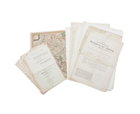
Schriftstücke und Dokumente aus Altdeutschland sowie aus dem Russ. Zarenreich - Briefe/Schreiben 18.Jh, /19.Jh., gesiegelter Schuldbrief Stuttgart 1791 und 1829, Urkunden über Verkäufe, Stuttgart 1761 und 1791, Gerichtsprotokoll Stuttgart 1803, Copia Memorialis, Rechnungen, 1 x Bayern/ Baden-Württemberg handkolorierte Kupferstichlandkarte, 18./19.Jh., "Sueviae nova tabula", Original gefertigt von Willem Blaeu in Amsterdam im 17.Jh. Diverse russische Dokumente aus der Zarenzeit und Weiteres. Stets mit Alters-und Gebrauchsspuren, stockfleckig, fleckig, Knicke, Einrisse, Verfärbungen, kleine Löcher. Am besten eingehend besichtigen!| Writings and documents from old Germany as well as from the Russ. Tsarist Empire - Letters/letters 18th/19th c., sealed promissory note Stuttgart 1791 and 1829, production documents for a sale, Stuttgart 1761 and 1791, court record Stuttgart 1803, Copia Memorialis, invoices, 1 x Bavaria/ Baden-Wurtemberg hand-coloured copper engraved map,18th/19th c., "Sueviae nova tabula", original once made by Willem Blaeu in Amsterdam in the 17th c. Various Russian documents from the time of the Tsar and others. Always with signs of age and use, foxing, stains, creases, tears, discolourations, small holes. Best to inspect in detail!
Lot 39
2 Kupferstichkarten Rheinland/Italien zum Polnischen Thronfolgekrieg,handkoloriert 18./19.Jh. - "Charte Geographique De La Campagne du Haut Rhin Pour L'année MDCCXXXIV Contenant Tous les Mouvemens Marches et Contremarches Des Armées Imperiales et Francoises Comme de même Une Designation du Rhin de puis Le Lac de Constance jusqu'à Mayance De Tout Le Neckar Et d'une Grande Partie du Main Par Jean Frederic Oettinger, Lieutenant au Regiment Des Gardes á pied de Wurtemberg pour le Service de Sa Maj. Imp. et Cathol. et Ingenieur", Johann Friedrich Öttinger und Matthaeus Seutter, 18./19.Jh. Rheinkarte von Strassburg bis Sigmaringen und von Hüningen bis Frankfurt. Auf beiden Seiten sind je 4 Darstellungen von Festungen (Neu Beysach, Alt Breysach, Strassburg, Fort Louys, Landau, Philippsburg, Manheim und Mainz). Unten Bataillonsordnung sowie Beschreibung des Weges von Prinz Eugenius u. Armee. Maße 119 cm x 54cm. Mit Alters- und Gebrauchsspuren, Knicke, Einrisse, fleckig. 1 x "Theatrum Belli per Italiam A MDCCXXXIV recentissima et accuratissima Designatio ubi et quuam diu Copiae Cæsareæ castra posuerint, commoratæ sint et cum hostibus conflixerint, cum delineatione præcipuarum urbium in hac plaga", Polnischer Thronfolgekrieg in Norditalien, M. Seutter, Karte umgeben von insg. 19 Schlachtplänen und Stadtansichten, Karte besteht aus 3 Blättern, Maße 62 cm x 120cm. Deutliche Alters- und Gebrauchsspuren, Einrisse, Verfärbungen, Knicke, Verschmutzungen.| 2 copper engraved maps Rhineland / Italy of the War of the Polish Succession, hand-coloured 18th/19th c. - "Charte Geographique De La Campagne du Haut Rhin Pour L'année MDCCXXXIV Contenant Tous les Mouvemens Marches et Contremarches Des Armées Imperiales et Francoises Comme de même Une Designation du Rhin de puis Le Lac de Constance jusqu'à Mayance De Tout Le Neckar Et d'une Grande Partie du Main Par Jean Frederic Oettinger, Lieutenant au Regiment Des Gardes á pied de Wurtemberg pour le Service de Sa Maj. Imp. et Cathol. et Ingenieur", Johann Friedrich Öttinger and Matthaeus Seutter, 18th/19th century. Rhine map from Strasbourg to Sigmaringen and from Hüningen to Frankfurt. On both sides are 4 representations of fortresses (Neu Beysach, Alt Breysach, Strasbourg, Fort Louys, Landau, Philippsburg, Manheim and Mainz). Below battalion order and description of the way of Prince Eugenius and his army. Dimensions 119 cm x 54cm. With age and wear marks, creases, tears, stained. 1 x "Theatrum Belli per Italiam A MDCCXXXIV recentissima et accuratissima Designatio ubi et quuam diu Copiae Cæsareæ castra posuerint, commoratæ sint et cum hostibus conflixerint, cum delineatione præcipuarum urbium in hac plaga", Polish War of Succession in Northern Italy, M. Seutter, map surrounded by 19 battle plans and city views, map consists of 3 sheets, dimensions 62 cm x 120cm. Clear signs of age and usage, tears, discolourations, creases, soiling.

Lot 4114
Johannes Blaeu (Dutch 1571-1638): 'Britannia Prout Divisa fuit Temporibus Anglo-Saxonum Praesertim Durante Illorum Heptarchia' (Britain as it was Divided During the Anglo-Saxon Times), engraved map of the British Isles with hand colouring and 14 Dutch style miniature vignettes depicting kings and scenes from Saxon history - the left border contains portraits of the earliest kings the right shows later kings in the process of conversion to Christianity, pub. c.1645, 42cm x 53cm


Lot 165
Mid 20th century P&O-Orient Line travel agents two volume cased set, comprising 'Manual of Information' section one containing details of 'Distance Tables', 'Route Map' 'Ports of Call', 'Cruising', and section two containing 'The Fleet', 'General Information and 'Index', in mahogany stand with gilt branded lettering, H32cm


Lot 106
NO RESERVE Africa.- Livingstone (David and Charles) Narrative of an Expedition to the Zambesi and its Tributaries; and of the Discovery of the Lakes Shirwa and Nyassa, first edition, engraved plates, large folding map bound in at rear, lacking frontispiece and publisher's advertisements, shot tear to title, lightly spotted and finger-soiled, map lightly browned, 8vo, 1865.

Lot 107
Africa.- Weinthal (Leo) The Story of the Cape to Cairo Railway and River Route, 4 vol. including map and index vol., (without separately-published supplement volume), maps, plates and illustrations, some mounted photographs, 11 folding maps only (of 12, in pocket of index vol.), original half morocco, spines gilt, lightly discoloured, index vol. rubbed and stained, a few scuffs, [Mendelssohn IV, pp.743-744], 4to, 923-25

Lot 109
Central Asia.- Stein (Sir Marc Aurel) On Ancient Central-Asian Tracks, first edition, frontispiece, folding map, plates, pencil annotations to margins, but a remarkably clean copy internally, original cloth, gilt, t.e.g., others uncut, light bumping to spine ends and corners, a little rubbed, light rubbing to covers, 1933; and 2 others on Central Asia, 8vo (3)

Lot 115
Menorca.- F. B. (A. A.) Istoria Dell' Isola di Minorica La Piu Piccola Fra le Baleari, engraved folding map, detached, lightly foxed and damp-staining to corner, disbound, 8vo, Firenze, Gaetano Cambiagi Stampator Granducale, 1781.⁂ A rare and sharp example of an 18th century map of the island of Menorca.

Lot 117
Polar.- Ross (Sir John) Narrative of a Second Voyage in Search of a North-West Passage and of a Residence in the Arctic Regions During the Years 1829, 1830, 1831, 1832, 1833, vol. 1, without appendix, first edition, 16 engraved plates, 6 lithographs and 3 hand-coloured mezzotints, 5 maps or plans, (including 1 large folding map, hand-coloured, with short tears), ex-library copy with stamps throughout, foxing, heavy in places, modern cloth-backed boards with morocco spine label, [Abbey Travel 636], 4to, 1835.

Lot 119
Russia.- Monteith (Lieut-General William) Kars and Erzeroum with the Campaigns of Prince Paskiewitch in 1828 and 1829, lithograph frontispiece, large folding map with some hand-colouring, without publisher's advertisements to rear, small holes to map joints, lightly browned along folds, light browning and marginal toning, map laid down to pastedown, one or two spots, original blind-stamped cloth, rather worn, 8vo, 1856.⁂ Scarce. Monteith was involved in the Russia-Persian wars to the extent that, as diplomat, he was commissioned to take the indemnity payment from the Persian to the Russian camp after the signing of the Treaty of Turkmenchay.

Lot 124
Bristol.- New History, Survey and Description of the City and Suburbs of Bristol (The), first edition, folding engraved map, Bristol, Printed, Published and Sold by W. Matthews, 1794; bound with Matthew's New Bristol Directory, last leaf soiled, Bristol, [1794], together 2 works in 1, uncut in old boards, rebacked § Shiercliff (E.) The Bristol and Hotwell Guide, folding engraved frontispiece, title browned, sewn as issued in original plain wrappers but lacking upper cover and backstrip, Bristol, 1789 § Crudge (John) Poems, partly descriptive of Bristol and its Environs, first edition, sewn as issued in original printed wrappers, Bristol, Published for the Author, 1836 § Account (An) of the Asylum for the Indigent Blind, in Bristol, engraved frontispiece, disbound, Bristol, [1809]; and a small quantity of others relating to Bristol including prints, photographs (some of the Bristol floods of 1889), a drawing of a balloon ascent in 1881 and an almost complete year (1816) of single-sheet printed broadside lists of ships in and out of the docks (nos.1-87, lacking only 5) with imprint Printed for George Worrall...by W. Major, each holed near top where presumably pinned to a board, 8vo (sm. qty)
-
109198 item(s)/page