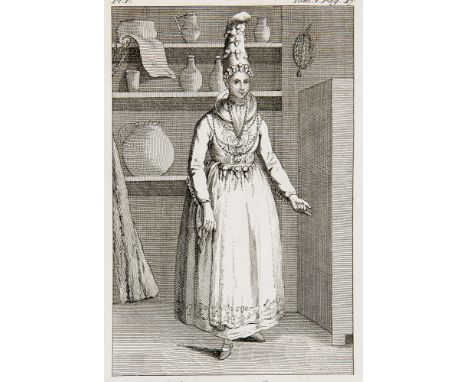

Island - - Eggert Olafsen und Biarne Povelsen. Voyage en Islande, fait par ordre de S.M. Danoise, contenant des observations sur les moeurs et les usages des Habitans; avec une description des Lacs, Rivières, Glaciers, Sources chaudes et Volcans; des diverses espèces de Terre, Pierres, Fossiles & Pétrifications; des Animaux, Poissons, Insectes, etc. Mit 60 gestoch. Tafeln. Paris, Levrault, 1802. 5 Bde. und Atlasband 8° u. 4°. Ppbde. d. Zt. u. spät Ppbd. (etwas bestoßen und berieben). Zur Zeit kein vollständiges Exemplar im internationalen Antiquariatshandel nachweisbar. Erste Ausgabe aus dem Dänischen übersetzt von Gauthier de Lapeyronie. Die Originalausgabe in dänischer Sprache erschien 1772. Diese französische Übersetzung hat 8 Tafeln mehr als die dänische Originalausgabe. Die früheste wissenschaftliche Arbeit über Island, die den Maßstab für alle nachfolgenden Islandstudien setzte. Die Tafeln zeigen die eigentümlichen isländischen geologischen Formationen, Vulkane, typisch isländische Vögel und Fische, Muscheln und isländische Tracht. Olafsen und Povelsen wurden von der Kopenhagener Akademie der Wissenschaften beauftragt, eine wissenschaftliche Reise nach Island zu unternehmen, um alle Aspekte der Insel zu untersuchen, von der sie damals nur vage und unvollkommene Vorstellungen hatten. Das Werk gibt einen Überblick über ihre Forschung. Schönes Exemplar des Atlas mit einer großen Faltkarte von Island und 59 botanischen, zoologischen und landskundlichen Tafeln. Titelseite des Atlas am Rand hinterlegt, eine Tafel mit hinterlegten Einriss am Rand, wenige Blätter am Rand etwas schmutzfleckig. - Insgesamt gutes Exemplar. At present no complete copy can be found in the international antiquarian book trade. First edition translated from Danish by Gauthier de Lapeyronie. The original edition in Danish appeared in 1772. This French translation has 8 plates more than the Danish original edition. The earliest scientific work on Iceland, which set the standard for all subsequent Icelandic studies. The plates show the peculiar Icelandic geological formations, volcanoes, typical Icelandic birds and fish, shells and Icelandic costume. Olafsen and Povelsen were commissioned by the Copenhagen Academy of Sciences to undertake a scientific trip to Iceland to study all aspects of the island of which they had only vague and imperfect ideas at the time. This work gives an overview of their research. Beautiful copy of the atlas with a large folding map of Iceland and 59 botanical, zoological and landscape panels. Title page of the atlas backed at margin, one plate with backed tear at margin, few sheets somewhat stained at margin. - Good copy overall.
We found 109182 price guide item(s) matching your search
There are 109182 lots that match your search criteria. Subscribe now to get instant access to the full price guide service.
Click here to subscribe- List
- Grid
-
109182 item(s)/page

Kuba - - Frédéric Mialhe. Album pintoresco de la Isla de Cuba. Mit chromolithogr. Titel und 26 Chromo-Lithographien von Frédéric Mialhe, getöntem gefalt. Plan und getönt. gefalt. Karte. (Berlin), May, ca. 1850. Quer-4°. Blindgeprägter Original Leinwand mit goldgeprägtem Deckeltitel. Erste Ausgabe. - Palau 167.989. - Sabin 17748. - Thieme-B. XXIV, 504. - Lipperheide Md 15. - Mit mehreren dekorativen Ansichten von Havanna, Trinidad und Matanzas sowie einige Genreszenen. Die großen, gefalt. Pläne (48 x 59 cm) jeweils mittig mit Plan bzw. Karte, umgeben von 13 bzw. 14 kleinenren Ansichten. - Gutes Exemplar. Blind embossed original cloth with gold embossed cover title. With several decorative views of Havana, Trinidad and Matanzas and some genre scenes. The big folded maps (48 x 59 cm) are centered with plan or map, surrounded by 13 or 14 smaller views. - Nice copy.

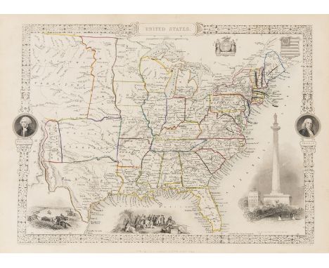
Amerika - - Calvin J. Smith. Colton's Map of the United States including Canada and a large portion of Texas. Showing the Base Meridian and Township Lines of the U.S. Surveys, the Lands allotted to the Indian Tribes west of the Mississippi. The Various Internal Improvements &c. Compiled from surveys at the United States Land Office, and various other authentic sources ... 1854. Handkolorierte gestochene Karte. 206 x 163. Kaschiert auf Leinen. Phillips, P.L. (Maps) p. 896. - Rumsey 2529.001. - Im Westen erstreckt sich ein riesiges Minnesota-Territorium bis zum Fluss Missouri, auf dem ein sehr großer Dakota County abgebildet ist. Auch ein großer Teil von Texas ist abgebildet. Das Territorium Nebraska erstreckt sich bis zur kanadischen Grenze, wobei eine Reihe großer Indianerreservate abgebildet ist, darunter auch Titonwans, Poncas, Omahas, Panwnees, Ottoes, Menomenies, Winnebagoes, Foxes & Sauks, Delawares, Kansas. - Unterhalb des Territoriums von Nebraska befindet sich ein riesiges "Westliches Territorium", einschließlich: Shawnees, Putawatomies, Propose Chippeways & utawatomies. Proposed For The New York Indians, Osages, Cherokee Land, Creeks, Seminoles, Choctawas, Chicasaws. - Enthält große Inset-Karten von Nordamerika und Florida. Die Grenzvignetten enthalten Stadtansichten von New York, Baltimore, Philadelphia, Washington usw., pastorale Szenen und mehr. - Karte gebräunt und wasserfleckig. - Selten. Handcoloured engraved map. - To the west, a vast Minnesota territory stretches to the Missouri River, which is home to a very large Dakota County. A large part of Texas is also depicted. The territory of Nebraska extends to the Canadian border, with a number of large Indian reservations depicted, including Titonwan's, Poncas, Omaha, Panwnees, Otto's, Menomenies, Winnebagoes, Foxes & Sauks, Delawares, Kansas. - Smaller tribal areas concentrated in the southeast corner. - Below the territory of Nebraska is a vast "Western Territory" including: Shawnees, Putawatomies, Propose Chippeways & Putawatomies. Proposed For The New York Indians Osages, Cherokee Country, Creeks, Seminoles, Choctawas, Chicasaws. Includes a large inset map of North America and Florida. The border vignettes contain city views of New York, Baltimore, Philadelphia, Washington etc., pastoral scenes and more. - Map is browned and waterstained. - Rare.

Amerika - - C. F. von der Heiden. Americanische Urquelle derer innerlichen Kriege des bedrangten Teutschlands, nach denen wahrhaftesten Umstanden und mit der genauesten Unpartheylichkeit nebst allen zu Erlauterung einschlagenden Nachrichten des Verhaltnusses der Englisch- und Franzosischen Handlung. Mit 80 st. 60 meist kolorierten Karten, Augsburg, G. C. Kilian, 1760. 4 Bll., 146 S. 1 Bll., 1 w. Bll., S. 3-130, 1-76 S. (komplett). HLdr. d. Zt. (teils berieben, bestoßen und beschabt). Sehr selten, zur Zeit kein Exemplar im internationalen Handel nachweisbar, nur drei komplette Exemplare seit 1949 auf Auktionen für uns nachweisbar. Holzmann-Boh. IV, 8621, nicht bei Sabin u. Howes. - Sehr seltene Geschichte des siebenjährigen Krieges mit besonderer Berücksichtigung des Kriegs zur See und des Kolonialkrieges zwischen Frankreich und England in Nordamerika und Kanada. Möglicherweise als fünfter Teil zu dem ebenfalls bei Kilian in Augsburg ersch. vierteiligen Werk "Das durch innerliche Kriege bedrangte Teutschland" hrsg. Enthält Karten und Pläne (auch Schlachtenpläne) von der Ostküste Nordamerikas, Neu-Schottland, Québec, Labrador, St. Lawrence, Mittelamerika, Inseln von West Amerika (Puerto Rico, Jamaica, Dominikanische Republik, Haiti, Golf von Mexiko, Martinique), Guadeloupe, Indien etc. Ferner Mallorca, Minorca, Frankreich. Mit der meist fehlenden Weltkarte, Europakarte, Asien, Afrika (verso mit gestochener Beschreibung). - Teils etwas gebräunt, die gefalteten Karten teils mit minimalen Knickspuren und Läsuren. - Sehr selten. With 80 instead of 60 mostly coloured plates. Contemp. half calf. - Very rare, at present no copy available in international trade, only three complete copies available at auctions since 1949. Holzmann-Boh. IV, 8621, not with Sabin and Howes. - Very rare history of the Seven Years War with special regard to the war at sea and the colonial war between France and England in North America and Canada. Possibly the fifth part of the four-part work "Das durch innerlicher Kriege bedrangtes Teutschland" (Germany beset by internal wars), also published by Kilian in Augsburg. Contains maps and plans (also battle plans) of the east coast of North America, New Scotland, Quebec, Labrador, St. Lawrence, Central America, islands of West America (Puerto Rico, Jamaica, Dominican Republic, Haiti, Gulf of Mexico, Martinique), Guadeloupe, India etc. Further Mallorca, Minorca, France. With the mostly missing world map, map of Europe, Asia, Africa (with engraved description on verso). - Partly a little bit browned, the folded maps partly with minimal creases and damages. - Very rare.
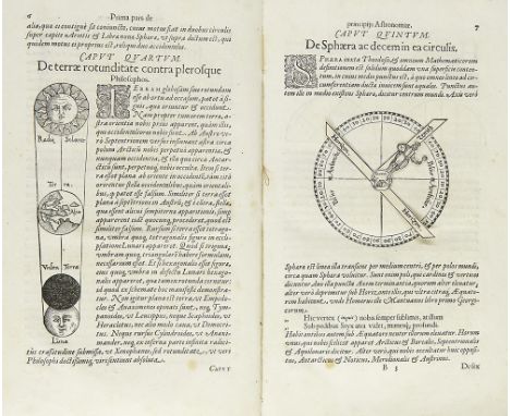
Johannes Myritius. Opusculum geographicum rarum. Mit Titelvignette, zahlr., teils blattgr. Textholzschn. (darunter 5 mit beweglichen Elementen) u. einer gefalt. Karte. Ingolstadt, W. Eder, 1590. 2 Bll., 130 (statt 136) S., 1 Bl. Fol. Pgt. d. Zt. aus Teilen eines Messbuch-Manuskripts aus dem 15. Jahrhundert (wasserfleckig und wurmstichig, Rücken etwas beschädigt, ohne die 4 Bindebänder, Innengelenke angeplatzt, Buchblock z.T. von Bindung gelöst). VD 16, M 7470. - Brown I, 323f. - Brown, European Americana 590/48. - Muller 1026. - Nordenskiöld 90 u. Taf. 49. - Sabin 51650. - Shirley 175 u. Abb. 142. - STC 641. - Stalla 1076. - Nicht bei Adams, Church u. Houzeau / L. - Arkway 45,23. - Portraits of the World, 7, S. 10f. - Außerordentlich seltenes geographisches Werk mit zahlreichen Holzschnitten, Volvellen und der Weltkarte. - "Merkwürdigerweise folgt der deutsche Geograph Myritius in seinem stark vereinfachten geographischen Bild nicht den in zahlreichen Karten dokumentierten neueren Kenntnissen über die Trennung von Asien und Amerika sowie die Gliederung Nordamerikas durch die Nordwestpassage" (America. Das frühe Bild der Neuen Welt. Ausstellung d. BSB München. 1992, Nr. 102 mit Abb.). - Ohne alle Widmungsblätter (= A2 & A3 mit den Widmungsbriefen und einem ganzseitigen heraldischen Holzschnitt, S. 131-136 mit dem Porträt und einem weiteren ganzseitigen heraldischen Holzschnitt, das vorletzte Blatt mit Kolophon und Druckermarke und das letzte weiße Blatt), aber der Text ist vollständig mit allen beweglichen Teilen und der Faltkarte. Die gefaltete Tafel (zu B3) mit den Volvelle-Teilen ist hier ausgeschnitten und montiert. Stellenweise leicht gebräunt und stockfleckig, leicht wasserandig und zu Beginn etwas wurmstichig, sonst in gutem Zustand. With title vignette, numerous text woodcut (among them 5 with movable devices) and one folded map. - Exceedingly rare geographical work with numerous woodcuts, volvelles and the world map. - "The author was a Malthese by birth, but resided a Ratisbon as a commander of the order of St. John. He seems to have been one of the latest geographers who, in order to reconcile the new discoveries (of Columbus et al.) with the original theories, calls the northwestern portion of America, India Orientalis, and places no ocean between the continents of Asia and America" (Sabin). - In a contemporary vellum binding made with parts of a 15th-century missal mss. (waterstained and wormed, some slight damage to spine, lacking the 4 ties, hinges cracking, bookblock partly detached). - Lacking all dedication leaves (= A2 & A3 with the dedicatory epistles and a full page heraldic woodcut, and pp. 131-136 with the portrait and another full-page heraldic woodcut, the penultimate leave with colophon and printer's device, and the final blank), never bound with, but the text is complete with all movable parts and the folding map. The folding plate (to B3) with the volvelle parts is here cut out and mounted. Some light browning and foxing, slightly waterstained and little worming to the beginning, else fine.

Russland - - Peter Simon Pallas. Voyages dans plusieurs provinces de l'Empire de Russie, et dans l'Asie septentrionale. Traduits de l'Allemand par Gauthier de la Peyronie. 4 Textbde. u. Atlasband. Mit 108 teilw. mehrfach gefalt. Kupfertafeln u. -Karten. Paris Lagrange/Maradan, 1788-1793. 4° u. Folio. Marmorierte Kalbsledereinbände d. Zt. mit goldgeprägten Fileten und reicher RVergoldung und grünen goldgeprägten RSchildern. Atlas in HLdr. (etwas berieben, beschabt und bestoßen). Erste französische Ausgabe. - Nissen, ZBI 3076. - Lipperheide 1336. - Henze III, 738. - Pallas (1741-1811) gilt als einer der bedeutensten deutschen Naturforscher und erhielt einen Lehrstuhl für Naturgeschichte in St. Petersburg. Zwischen 1768 und 1774 führte er im Auftrag von Zarin Katharina II. seine berühmt gewordene Expedition vom mittleren Ural über Westsibirien bis zur kaspischen Senke durch. Auf der Expedition begleiteten ihn wichtige Naturforscher wie Johann Peter Falck, Johann Gottlieb Georgi und Iwan Bykow, Nikita Petrowitsch Rytschkow, oder Nikita Petrowitsch Sokolow. Der prachtvolle Tafelband zeigt zahlreiche indigene Völker Russlands, prachtvolle Pflanzen und Tierdarstellungen, sowie wichtige und seltenen Karten (darunter die Wolga-Deutschen) und Monumente. Die große, mehrf. gefalt. Karte "Carte générale de l'empire de Russie" lose beil., zusätzlich die grenzkolorierte Karte "Russie d'Europe Partie Méridionale" von Delamarche im Atlas eingebunden. - Die Textbde. mit Goldschnitt. Die Seiten teils nur mit leichteren Flecken bzw. gebräunt, 2 Taf. mit kleinen Defekten (alt hinterlegt). - Insgesamt gute Exemplare in dekorativen Einbänden. First French edition. With 108 partly folded engraved plates and maps. 4 text volumes and Atlas. Marbled calf leather bindings with gilded fillets and rich spine gildung and green spine labels. Atlas in halfcalf. (Slightly rubbed and chafed, slightly bumped). - Pallas is one of the most important German zoologist and botanist. He was professor in St. Petersburg and directly instructed by Tsar Catherina II. an expedition through Russia. He was accompanied by important colleagues (as listed above). The impressive atlas volumes is showing numerous indigenious tribes and people of Russia, impressive plants and animals and important and rare maps (there under the Volga-Germans) as well as Monuments. "Carte générale de l'empire de Russie"(loose), added the outline coloured map "Russie d'Europe Partie Méridionale" by Delamarche. The pages mostly well presvered and only sometimes with stains or slight browning, 2 plates with small repaired defects (old backed). - The text volumes with gilded edges. - Altogether well presevered copies in decorative contemporary bindings.

Atlanten - - Abraham Ortelius. Theatrum Orbis Terrarum. Mit koloriertem Kupfertitel und 91 meist doppelblattgroßen kolorierten Kupferkarten auf 70 Bll. Antwerpen, A. C. van Diest 1574. Folio. 10 Bll., 70 numm. Bll., (1 S.), 48 Bll. Moderner rotbrauner Lederband im Stil d. 18. Jahrhunderts mit goldgeprägter Filete und Eckfleurons, sowie goldgeprägt RSchild. heatrum, Ort. 12 . - Vierte lateinische Ausgabe, welche erstmals 1570 mit 53 Karten erschienen. Vollständiges Exemplar. Die meist von Frans Hogenberg gestochenen Karten zeigen die Welt in oval, die Kontinente Amerika, Asien, Afrika, Europa, Teilkarten von Europa mit England, Wales, Schottland, Irland, Spanien, Portugal, Frankreich (mit Teilkarten von Bourges, Loire, Calais und Vermandois, Narbonne, Burgund) Deutschland (eigentlich Mitteleuropa, mit Teilkarten von Niedersachsen, Dithmarschen, Mansfeld, Bayern, Franken, Sachsen, Pommern, Preussen, Schwaben, Thüringen, Würrtemberg u.a.), Niederlande und Belgien, Skandinavien (mit Teilkarten von Dänemark), Böhmen, Mähren, Schlesien, Schweiz, Österreich (mit Teilkarten von Tirol, Salzburg), Italien (mit zahlreichen Teilkarten), Zypern, Polen (mit Teilkarten u.a. Livland), Griechenland, Ungarn, Transsylvanien, Balkan, Baltikum, Russland, Persien, Indien, Türkei, Arabien (mit Teilkarten von Palästina, Ägypten, Kathargo, Kleinasien), sowie Abessinien, die mythologische Karte des Königreiches des Priesterkönigs Johannes in Afrika. Die Karten in überwiegend guten und gratigen Abdrücken meist prachtvollen Flächen- und Grenzkolorit verziert mit eindrucksvollen Rollwerkkartuschen, Segelschiffen und Seeungeheuern. Dabei werden die exotischen Länder und Gegenden oft angereichert mit einheimischen Bewohnern und Tieren. - Sauberes Exemplar, wenige Seiten mit minimalen alten Hinterlegungen, nur wenige Blätter nur am Außenrand selten etwas braun- bzw. wasserfleckig. Insgesamt sehr gutes meist breitrandiges Exemplar dieses berühmten Atlas. With coloured engraved title and 91 mostly double paged coloured engraved maps on 70 leaves. - Modern handbound full morocco leather binding in 18th. century stlye with gilded fillets, fleurons and gilded spine title. - Fourth latin edition, which was published in 1570 with 53 maps. Complete copy. Most of the maps engraved by Frans Hogenberg show the world in oval, the continents America, Asia, Africa, Europe, partial maps of Europe with England, Wales, Scotland, Ireland, Spain, Portugal, France (with partial maps of Bourges, Loire, Calais and Vermandois, Narbonne, Burgundy) Germany (actually Central Europe, with sub-maps of Lower Saxony, Dithmarschen, Mansfeld, Bavaria, Franconia, Saxony, Pomerania, Prussia, Swabia, Thuringia, Würrtemberg, etc.), Netherlands and Belgium, Scandinavia (with partial maps of Denmark), Bohemia, Moravia, Silesia, Switzerland, Austria (with partial maps of Tyrol, Salzburg), Italy (with numerous partial maps), Cyprus, Poland (with partial maps ia Livonia), Greece, Hungary, Transylvania, Balkans, Baltic States, Russia, Persia, India , Turkey, Arabia (with partial maps of Palestine, Egypt, Kathargo, Asia Minor), as well as Abyssinia, the mythological map of the kingdom of the Priest-King John in Africa. The maps in predominantly good and impressions with high contrasts usually magnificent surface and border coloured. Enriched with impressive volute cartouches, sailing ships and sea monsters. The exotic countries and areas are often enriched with native inhabitants and animals. - Clean copy, some pages with minimally old backings, some leafs only at the outer margin slightly brown respectivley minimally waterstained. Altogether a very good and mostly broad margined copy of this famous atlas.

Boxed Denys Fisher The Six Billion Dollar Colonel Steve Austin action figure, missing engine block accessory and box showing repairs. Plus boxed The Bionic Woman Jaime Sommers action figure (missing Map Case, Mission Purse and some other accessories) and boxed Bionic Transporter & Repair Station, (appearing complete but unchecked), playworn Six Million Dollar Man Colonel Steve Austin action figure and Six Million Dollar Man 1977 annual.

Two boxed Lego Harry Potter sets to include 4841 Hogwarts Express (missing Ron minifigure, brown & grey Owls, Chocolate Frog, Ice Cream and Hostess Trolley) and 4841 Hogwarts Castle (missing a few non-structural pieces to include 2 Owls, map, newspaper, books and goblety. Box and instructions are water damaged but fully legible)


Architecture.- Chamberlain (Henry, editor) A New and Compleat History and Survey of the Cities of London and Westminster...By a Society of Gentlemen, first edition, engraved frontispiece, 2 folding maps and 64 engraved plates, list of subscribers, some light spotting and offsetting, map of environs of London with tear to fold, Pp2 torn without loss, pencil inscription of Kerry Downes, contemporary calf, spine gilt with red morocco label, a little worn, joints split, folio, for J. Cooke, [?1770].

Birds.- Lilford (Lord) Notes on the Birds of Northamptonshire and Neighbourhood, 2 vol., large paper edition limited to 100 copies, half-title, frontispiece, plates (woodcuts and photogravures), photogravures after Thorburn, large folding map backed onto linen, occasional marginal spotting, bookplate, previous owner's ink signature, near contemporary half-morocco by Bickers & Son, sunned spines, slight bumping to corners and extremities, 4to, 1895.

NO RESERVE World.- Tooley (R. V.) Collectors' Guide to the Maps of the African Continent and Southern Africa, first edition, frontispiece, plates, original cloth, dust-jacket, slight chipping to extremities, 1969; Maps and Map-Makers, frontispiece, plates, original cloth, dust-jacket, slight creasing to extremities, 1982 § Blaeu's The Grand Atlas of the 17th Century World, double-page illustrations, original cloth, dust-jacket, slight creasing to extremities, 1990; and 9 others, similar, v.s. (12)
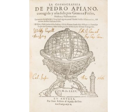
World.- Apianus (Petrus) La Cosmographia, corregida y añadida por Gemma Frisio, Spanish edition, collation: A-Y⁴, title with large woodcut of globe, numerous woodcut illustrations and initials including 4 volvelles (C2 ͮ, D1 ͮ, I1 ͬ misbound & P3 ͬ), I1 taken from a different edition and misbound as I4, lacking world map and sheet 31, ink manuscript notes to title, occasional scattered spotting, bookplate of Fuerstlich Auerspergsche Fideicommisbibliothek zu Laybach, near contemporary limp vellum, a little browned, title in manuscript to spine, [Sabin 1756], 4to, Antwerp, Juan Bellero, 1575.

Scotland.- Gordon (Alexander) Itinerarium Septentrionale: or, a Journey thro' most of the Counties of Scotland, large folding engraved map, laid down, 66 engraved plates, some folding or double-page, list of subscribers, short cuts to lower margins not affecting text (2N2-2P1), modern half calf, slight bumping to corners and extremities, folio, 1727.

Birds.- Lilford (Lord) Notes on the Birds of Northamptonshire and Neighbourhood, 2 vol., frontispieces, plates and illustrations, occasional very faint spotting, bookplates, original half-morocco, lightly faded spines, 1895 § Borrer (William) The Birds of Sussex, chromolithographed frontispiece, plates, folding map, previous owner's ink inscription, occasional faint spotting, cracked hinges, original cloth, a little rubbed, slight bumping to corners and extremities, 1891 § Witherby (H. F.) and others. The Handbook of British Birds, 5 vol., plates and illustrations, spotting, bookplates, original cloth, a little rubbed, slight bumping to corners and extremities, dust-jacket to vol. 5 only, a little rubbed, small loss to corners and spine extremities, 1938-1941; and 16 others similar, v.s. (24)
![Japan.- Fugestu (Shozaemon) Kyoto ku kumiwake saizu [Map of Kyoto Prefecture], colour printed woodcut, on thin japan, sheet 4](https://cdn.globalauctionplatform.com/ef2089c3-b942-41e9-9eda-ac7d00b61675/e3002bb1-4d88-47a4-a52f-ac8000a8e7c8/468x382.jpg)
Japan.- Fugestu (Shozaemon) Kyoto ku kumiwake saizu [Map of Kyoto Prefecture], colour printed woodcut, on thin japan, sheet 475 x 720 mm (18 3/4 x 28 1/4 in), folding with original yellow endpapers with publisher's label to upper cover, slightly rubbed and scuffed, 8vo, [circa 1880]; together with a group of six folding maps of Asia and the East Indies, including Andriveau-Goujon's Carte de L'Asie Orientale comprenant L'Empire Chinois, Le Japon, Girard et Barrere's Carte de Chine, Japon Manchukuo, two part 19th century folding German maps of Kiautschou Bay, and a folding lithographed map of Vietnam, Voyage de S.E. Le Jonkheer de Graeff, and Thacker's Reduced Survey Map of India by J.G. Bartholomew, various sizes, 8vo, 19th century (7)

Asia.- Speed (John) A Newe Mape of Tartary, detailed map showing from Lake Baikal through the regions of present-day Manchuria and Siberia to the north of the Great Wall of China, with Korea as an Island, featuring 8 side panels with the people of Tartary in their native costume, and four vignette views above of Nova Zembla, and the silk route cities of Astrakan, Samarkand and Cambalu, engraving with hand-colouring, on laid paper with watermark of fleur-de-lis, platemark 400 x 515 mm (15 3/4 x 20 1/4 in), sheet 430 x 565 mm. (17 x 22 1/4 in), central vertical fold as issued, with toning to sheet and exposure lines from previous mount, spotting and surface dirt, unframed, Bassett and Chiswell, [1676]; together with A New Map of Turkey in Asia by Monsr. D'Anville, engraving with hand-colouring, sheet 570 x 815 mm (22 1/2 x 32 in), unframed, 1794; and with Bellin's Carte de L'Entrée de la Riviere de Canton, engraving with hand-colouring, 280 x 220 mm (11 x 8 3/4 in), unframed, [1764] (3)

Africa.- Hondius (Henricus) Africae nova Tabula Auct. Hen. Hondio., detailed and decorative map of the continent from 'Atlas Novus', featuring sailing ships, flying fish, various sea monsters, and Neptune with a mermaid, inland is decorated with elephants, lions, zebras, ostriches, and a dragon, engraving with hand-colouring, platemark 380 x 500 mm (15 x 19 3/4 in), sheet 495 x 580 mm (19 1/2 x 22 3/4 in), central vertical fold with repairs verso to splitting at head and foot, scattered spotting and browning, unframed, 1631; together with 3 others, including Blaeu's Guinea, Sanson's L'Afrique, ou Lybie Ulterieure: ou Sont Le Saara, ou Desert, Le Pays de Negres, La Guinee, and Pieter van den Keere's Africa, engravings, various sizes, unframed, 17th century (4)

East Indies.- Sanson (Nicolas) Partie Meridionale de l'Inde en Deux Presqu'Isles, l'une deca et l'autre dela le Gange..., map of southern Asia extending from India in the west to Sumatra and Borneo in the east, with part of China in the north east, decorative title within a clam shell in the lower centre, engraving with outline hand-colouring on laid paper with watermark of a large ornate coat of arms, platemark 385 x 530 mm. (15 1/4 x 20 7/8 in), sheet 435 x 580 mm. (17 1/8 x 22 3/4 in), central vertical fold as issued, minor nicks to extremities, some toning and browning, minor damp-stains and some surface dirt, unframed, Pierre Mariette, 1654.
Atlases.- Martin (Robert Montgomery, editor) The Illustrated Atlas..., and Modern History of the World, Geographical, Political, Commercial, and Statistical, engraved pictorial title, 2 engraved comparative plates of rivers and mountains in the eastern and western hemispheres and 80 engraved maps with vignette illustrations and hand-coloured in outline, some light marginal soiling, title with short tear to lower edge just extending into imprint, some maps with stab-holes to outer edge, loose in binding, contemporary half straight-grain morocco, worn, folio, J. & F.Tallis, [c.1856].⁂ Map of Mexico, California and Texas including vignette of gold-panning and with gold regions highlighted in yellow.

NO RESERVE Africa.- Cape Verde.- Jansson (Jan) Insulae de Cabo Verde Olim Hesperides, sive Gorgades, engraving on laid paper, platemark 440 x 555 mm. (17 1/4 x 21 3/4 in), sheet 510 x 600 mm. (20 x 23 5/8 in), Latin text verso, central vertical fold with some splitting to margins, minor surface dirt, unframed, [circa 1657 and later] § Coronelli (Vincenzo Maria) Bocche del Fiume Negro et Isole di Capo Verde, showing Cape Verde Islands and of part of the coast of Senegal to the right, engraved map, on laid paper with swallowtail flag watermark, platemark 460 x 615 mm. (18 1/8 x 24 1/4 in), lower edge re-margined, some nicks and tears, minor handling creases, unframed, Venice, Padovani, [circa 1696] (2).

Scotland.- Beattie (William) Scotland Illustrated, 2 vol., additional engraved titles and 118 plates, tissue-guards, folding map, short marginal tear, occasional spotting, occasional faint marginal staining, original morocco, gilt, a little rubbed, slight bumping to corners and extremities, 4to, 1838.
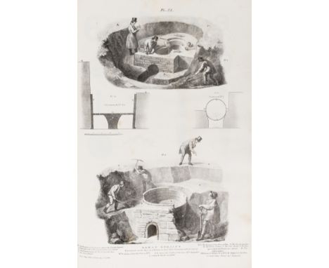
NO RESERVE Archaeology.- Artis (Edmund Tyrell) The Durobrivae of Antoninus...Roman Station in the vicinity of Castor, Northamptonshire, first edition, folding hand-coloured engraved map and 59 engraved or lithographed plates and plans, some with aquatint, 4 folding or double-page, 10 hand-coloured, light spotting or water-staining to a couple of plates, bookplates of George E.Foe and Will.Stephenson, contemporary half roan, rubbed and stained, spine worn and torn, upper cover detached, folio, for the Author, 1828.⁂ Handsome work on the various Roman sites around Castor, Northants., including views, plans and plates of the mosaics, building materials, furnaces, pottery, jewellery, and household utensils.
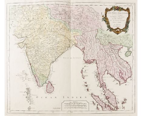
East Indies.- Santini (Paolo) Les Indes Orientales..., map showing India, Thailand, Cambodia, Vietnam, Malaysia, the island of Sri Lanka, the Maldives, and a portion of Sumatra, and includes Singapore, engraving with hand-colouring, sheet 530 x 625 mm (20 7/8 x 23 1/2 in), central vertical fold with minor splitting to foot, some surface dirt to edges, light handling creases, unframed, Venice, Remondini, 1779; together with four other maps of the region, including Bowen's A New and Accurate Map of the Empire of the Great Mogul, d'Apres de Mannevillette's Carte de la partie comprise entre la sortie du détroit de Malac and A chart of the eastern coast of the Gulf of Bengal, and with Jansson's map of the Spice Islands, Insularum Moluccarum Nova Descriptio, enrgavings, some hand-colouring, various sizes, all unframed, 17th and 18th century (5)

NO RESERVE Africa - Madagascar.- Sanson (Nicolas, publisher) Isle d'Auphine, Communement Nommee par les Europeens Madagascar, et St. Laurens, et par les Habitans du Pays Madecase..., large-scale map of Madagascar and the surrounding islands in the Indian Ocean off the southeast coast of Africa, engraving on laid paper with watermark of decorative coat of arms, sheet 620 x 455 mm (24 1/4 x 18 in), central horizontal fold, some nicks and tears, occasional handling creases, minor surface dirt, unframed, Paris, 1697; together with Emanuel Bowen's Particular Draughts of Some of the Chief African Islands in the Mediterranean, showing St Helena, Malta, Tenerife, Cape Verde, and Madeira, engraving, sheet 405 x 490 mm (15 7/8 x 19 1/4 in), old folds and surface dirt, some browning, unframed, [c. 1760] (2).
Birds.- Crawshay (Richard) The Birds of Tierra del Fuego, first edition, limited edition of 300, this copy 'out of series', 21 hand-coloured lithographed plates, 23 photogravure plates, colour map at end, bookplate, hinges strengthened, contemporary morocco-backed boards, slight bumping to corners and extremities, 4to, 1907.
![NO RESERVE London.- [Grant (James)] The Great Metropolis, 2 vol. in 1, half-titles, original green cloth, uncut, spine faded,](https://cdn.globalauctionplatform.com/ef2089c3-b942-41e9-9eda-ac7d00b61675/87730fcd-5c5c-4e01-b1f3-ac8000a936e7/468x382.jpg)
NO RESERVE London.- [Grant (James)] The Great Metropolis, 2 vol. in 1, half-titles, original green cloth, uncut, spine faded, New York, 1837 § Baines (Thomas) Liverpool in 1859, folding map, 8pp. advertisements printed on pink paper at end (faded at edges), also 4pp. on the Royal Insurance Company printed in red and green, original blind-stamped cloth, London, Liverpool & Manchester, 1859, both a little rubbed, the second faded at edges and worn at head of spine, 8vo (2)⁂ The first is an interesting work on London, published using the sheets of the London edition with a New York imprint. There is information on theatres, clubs, gaming houses, and newspapers.

Africa.- Keulen (Gerard van) De Stad Haven En Mouillie Van Algiers Neven Desselfs Kasteelen, double-page bird's-eye view of the port and city of Algiers, with detailed key in the lower right corner, engraving with hand-colouring, on laid paper with watermark initials 'CWP', sheet 540 x 610 mm (21 1/4 x 24 in), central and lower vertical folds, left edge expertly restored, some minor nicks and handling creases, unframed, Amsterdam, [circa 1720]; together with W. Segher's poster map showing from Italy to Abyssinia, numerous folds and splits, unframed, 1935 (2)

Africa.- Hondius (Jodocus) Nova Africae Tabula Auctore Jodoco Hondio, detailed and decorative map of the continent featuring sailing ships, various sea monsters, and strapwork cartouche in the lower left corner, engraving with hand-colouring on laid paper without watermark, platemark 380 x 500 mm (15 x 19 3/4 in), sheet 440 x 550 mm (17 1/4 x 21 3/4 in), Latin text verso, margins inset onto old paper support, central vertical fold with repaired splitting and support verso, minor browning, mainly to margins, unframed, [Amsterdam, circa 1606].Literature:Tooley p. 54

India & Ceylon.- Homann Heirs. Peninsula Indiae citra Gangem, hoc est Orae Celeberrimae Malabar & Coromandel. Cum Adjacente Insula non Minus Celebratissima Ceylon, map of the southern part of India and Sri Lanka, with colonial possessions and trading posts delineated with flags along the coastline, decorative title cartouche with elephant in the lower left corner, engraving with hand-colouring on laid paper with cross-based watermark, platemark 570 x 505 mm. (22 1/2 x 19 7/8 in), sheet 590 x 520 mm. (23 1/4 x 20 1/2 in), central horizontal fold as issued, some toning, mainly to margins, some handling creases and surface dirt, unframed, 1733.

Pakistan, Afghanistan & Northern India.- Jansson (Jan) Magni Mogolis Imperium, map of the Empire of the Great Mogul in northern India including the region from Iran to Burma, decorated with title in the upper left corner, and with numerous elephants, big cats, and a camel, engraving with some outline hand-colouring on laid paper, platemark 370 x 495 mm. (14 1/2 x 19 1/2 in), sheet 505 x 600 mm (20 x 23 1/2 in), good margins, central vertical fold as issued, some splitting to head and foot of fold, a few pin holes repaired verso, minor spotting and browning, unframed, [circa 1650 and later].
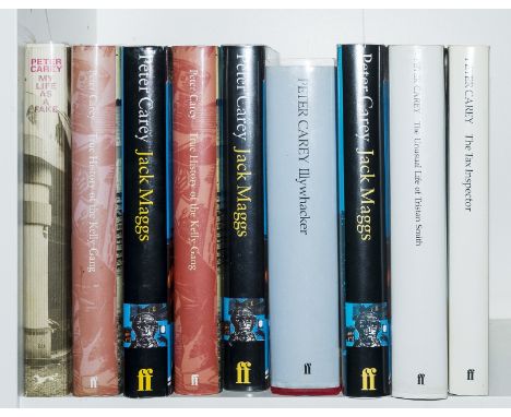
NO RESERVE Carey (Peter) My Life as a Fake, first edition, signed presentation inscription from the author to Tariq Ali, jacket upper panel with short tear to head and some patch of foxing to foot, light discolouration to spine, Sydney, 2003; True History of the Kelly Gang, first English edition, signed by the author, "Ned Kelly's Australia" map loosely inserted, jacket with light sunning to spine, 2001; Jack Maggs, first English edition, signed presentation inscription from the author, jacket with light creasing to spine ends, 1997, original boards, dust-jackets, excellent or near-fine; and 6 others by the same, 8vo (9)

World.- Apian (Peter) Charta Cosmographica, Cum Ventorum Propria Natura et Operatione, cordiform world map based on the larger map of the world by Gemma Frisius, from the 3rd block as described by Shirley with flourish to the 'A' of America, from 'Cosmographia Petri Apiani...', woodcut on laid paper with indistinct watermark, sheet 235 x 320 mm (9 1/4 x 12 1/2 in), old folds as issued, some repairs to splitting, minor spotting and surface dirt, unframed, [Cologne, 1574]Literature: Shirley 131
![NO RESERVE Britain.- [Gough (Richard)] British Topography..., 2 vol., first edition, engraved title vignettes, 7 folding engr](https://cdn.globalauctionplatform.com/ef2089c3-b942-41e9-9eda-ac7d00b61675/0bbff311-4110-4613-8e16-ac8000a96226/468x382.jpg)
NO RESERVE Britain.- [Gough (Richard)] British Topography..., 2 vol., first edition, engraved title vignettes, 7 folding engraved maps and large map (plate 8) in 3 parts, bookplate of George Gallwey Mills, contemporary russia, rubbed, spines worn, joints split, covers of vol.1 detached, 4to, T.Payne & Son, and J.Nichols, 1780.

Ancient World.- d'Anville (Jean Baptiste Bourguignon) Orbis Veteribus Notus, map of Asia and Europe centred on Saudi Arabia, engraving with some outline hand-colouring, sheet 550 x 810 mm (21 3/4 x 31 3/4 in), central vertical fold with splitting, surface dirt and ink stains, minor browning, handling creases and faint damp-stains, unframed, [Paris], 1783; together with 10 further maps by D'Anville, including the two-sheet map Prémière Partie de la Carte d'Europe, Asiae, quae vulgó Minor dicitur, et Syriae, Tabula Italiae Antiquae Geographica, Gallia Antiqua ex Aevi Romani Monumentis, Orbis Romani Pars Occidentalis, Aegyptus Antiqua, and others, engravings, various sizes, spotting, surface dirt, browning and minor damp-stains throughout, all unframed, [circa 1780s] (11)

![[SHIPPING INTEREST]. A HOLLAND-AFRICA LINE ROUTE NETWORK WALL MAP, 1954 by George Philip & Son, Ltd, with baton supports](https://cdn.globalauctionplatform.com/0d0d12d3-30ca-4b3a-bf91-ac6f009412dd/4a17eb25-249d-4577-9b4b-ac80013acb7c/468x382.jpg)
![[CHILDRENS] Milne, A.A. Winnie-the-Pooh, first edition, Methuen, London, 1926, dark green cloth gilt, top edges gilt, map en](https://cdn.globalauctionplatform.com/0d0d12d3-30ca-4b3a-bf91-ac6f009412dd/3660c609-1c3b-4fb0-a39e-ac8300c1df05/468x382.jpg)


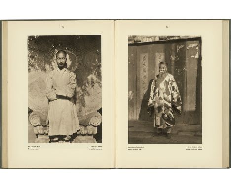
Perckhammer, Heinz: Peking Peking. With an introduction by Arthur Holitscher. XIV, 200 p. with 200 illustrations and 1 map. 30 x 22,5 cm. Original grey linen with blue pressed title on cover and spine (faded). Berlin, Albertus-Verlag, 1928. First edition. Perckhammer's photographic study of Peking, China from 1928. – In very good condition. – With: Chine. With text by Paul Claudel. 3 l., 80 p., 3 l. with 26 plates with illustrations after photographs by Hélène Hoppenot printed in fine rotogravure. 35,5 x 26,5 cm. Original wrappers (slightly dusty, edges soiled/rubbed, some staining). Paris, D'Art Albert Skira, 1946. - Binding slightly loose, slight traces of use. Perckhammer, Heinz: Peking Peking. With an introduction by Arthur Holitscher. XIV, 200 p. with 200 illustrations and 1 map. 30 x 22,5 cm. Original grey linen with blue pressed title on cover and spine (faded). Berlin, Albertus-Verlag, 1928. First edition. Perckhammer's photographic study of Peking, China from 1928. – In very good condition. – With: Chine. With text by Paul Claudel. 3 l., 80 p., 3 l. with 26 plates with illustrations after photographs by Hélène Hoppenot printed in fine rotogravure. 35,5 x 26,5 cm. Original wrappers (slightly dusty, edges soiled/rubbed, some staining). Paris, D'Art Albert Skira, 1946. - Binding slightly loose, slight traces of use.
![[DAVOUT LOUIS NICOLAS]: (1770-1823) Marshal of France, Duc d´Auerstaedt and Prince of Eckmuhl. Known as the Iron Marshal, Dav](https://cdn.globalauctionplatform.com/e999f7c7-3654-40ec-97bd-ac6f00c99025/604b660b-e60c-4600-9594-ac70011d9013/468x382.jpg)
[DAVOUT LOUIS NICOLAS]: (1770-1823) Marshal of France, Duc d´Auerstaedt and Prince of Eckmuhl. Known as the Iron Marshal, Davout was the only Napoleonic Marshal not to have been defeated in battle by 1815. Attractive 16 x 21 contemporary printed public notice, one page, Paris, 10th April 1815, in French. The Affiche announcement bears an attractive vignette to the heading with a crowned eagle and is issued during the Hundred Days, and only few weeks after Napoleon´s return from his exile on the island of Elba. The printed heading states “Proclamation - the Minister of War - To all non-commissioned Officers and Soldiers on leave or retreated in French territories”. The proclamation harangues the crowds claiming `You have wanted your Emperor, he has arrived. Come and be ready to defend your Homeland against the enemies who will want to decide the colours we should wear, to impose the Souvereigns and dictate constitutions.”, further saying “Soldiers,.. if your wounds have healed, if you can serve, come, the Honour, the Emperor and the Homeland are calling you. What complaints would you not have to make to yourself if ….foreigners would withdraw France out of the map of Europe!” Bearing multiple and clean contemporary annotations to the verso. Folded, with trimmed edges. G Napoleon Bonaparte returned from the island of Elba on 20th March 1815, starting the historical period known as The Hundred Days war, or the War of the Seventh Coalition which lasted until 8th July 1815, ending with the second restoration of King Louis XVIII.


ACKERMANN, FRANZ ACKERMANN, FRANZ 1963 Neumarkt-St. Veit Titel: Mental Map. Untertitel: Konvolut von zwei Werken: a) The election, b) Soft landing. Datierung: Jeweils: 2001. Technik: Mischtechnik auf Papier. Maße: 13 x 19cm. Bezeichnung: Beide betitelt signiert und datiert verso: The election bzw. Soft landing Franz Ackermann 01. Rahmen/Sockel: Jeweils Rahmen. Provenienz: - Giò Marconi, Mailand (Aufkleber) - Privatsammlung Italien Den Werken liegt jeweils ein vom Künstler unterzeichnetes Zertifikat der Galerie Giò Marconi, Mailand, bei. Erläuterungen zum Katalog Franz Ackermann Deutschland Zeitgenössische Kunst Unikate 2000er Stadtlandschaft Papierarbeit Mischtechnik ACKERMANN, FRANZ ACKERMANN, FRANZ 1963 Neumarkt-St. Veit Title: Mental Map. Subtitle: Mixed lot of two works: a) The election, b) Soft landing. Date: Each: 2001. Technique: Mixed media on paper. Measurement: 13 x 19cm. Notation: Both titled, signed and dated verso: The election or Soft landing Franz Ackermann 01. Frame/Pedestal: Each framed. Provenance: - Giò Marconi, Mailand (label) - Private collection Italy Enclosed is a signed cetritifcate of Galerie Giò Marconi, Milan of each artist. Explanations to the Catalogue Franz Ackermann Germany Contemporary Art 2000s Cityscape Works on paper Mixed media


Ephemera, 170+ items dating from the late 19th/mid 20thC to include Chislehurst Golf Club Route Map of South London, Ringwould Riding School brochure, cookery leaflets (Colman, Veltex, Brown & Polson), Meccano instructions, letters, menus, calendars, Mazawattee calendar, die cut advertising insert, invitations etc. also includes 50+ property auction catalogues and flyers for the Lincolnshire region (gen gd) (170+)

Cigarette cards, two albums containing an interesting selection of odds & part sets, many scarce cards noted but in various condition, inc. Morris Golf Strokes (20), Australian Cricketers (15), Sarony Tennis Strokes (17), Anstie's Scout Series (46), Racing Series (50), Baker Beauties of All Nations (10, some trimmed), several BAT issues, Edwards, Ringer & Bigg Dogs (35 inc. some duplicates), Our Pets (36), War Map of the Western Front (38), various Faulkner's cards inc. Angling, South African Series, 'Ation' Series etc, also Cohen, Weenen, Hignett's, Hill's, Franklyn, Davey, Lea & others (condition very mixed, poor/gd) (1200+ cards)

Postcards, Comic, a collection of approx. 520 mainly post WW2 comic cards with many Bamforths (1970/80's). Artists inc. Trow, Quip, Fitzpatrick, Taylor, Chas (much duplication). Also approx. 100 mostly 1950's comic again with many Bamforths but also McGill, Lawson Wood, Phylis Purser, Harry Parlett etc. Sold with approx. 280 modern map cards (mixed condition, fair/gd)
Military Ephemera, a large quantity of military items to include cotton escape maps 66-B, 66-C, 66-F and 66-G all Anglo-Egyptian Sudan, silk escape map Sheet A (France Belgium Holland), WW1 and WW2 magazines, Civil Defence training booklets, maps, certificates, photographs, manuals, jigsaw puzzles, playing cards, company orders, 2 Essex Regt badges and pips etc. (mixed condition fair/gd) (qty)

Cartography - Paterson (Daniel, Esq., Assistant Quarter-Master General of His Majesty's Forces): Paterson's British Itinerary/Being A new and accurate Delineation and Descriptions of the Direct, and Principal Cross Roads of Great Britain, second edition, two-volume set, London: Printed for the Proprietors, Bowles & Carver, 1796, pp: two-page map, [3], xxxv, [1], maps 1-340, 341-403, [3] (blanks); [4] (blanks), [2], maps 404-449, 450-634, [3] blanks, contemporary mottled calf, gilt-lettered red and green morocco pieces, 8vo, (2); A New and Accurate Description of all the Direct and Principal Cross Roads in Great Britain [...], three copies: third edition, 1776, eighth edition, 1789, and tenth edition, 1794, various contemporary bindings, each with contemporaneous and/or later ownership inscriptions, 8vo, (3), [5]
-
109182 item(s)/page