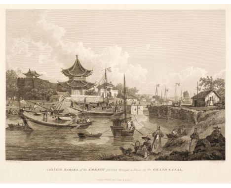

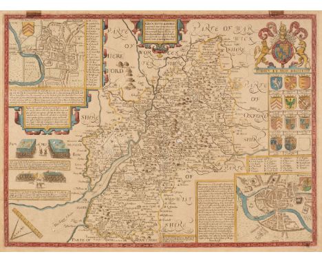
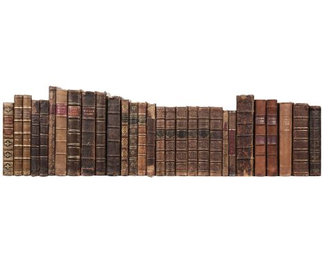
Staunton (George). [An Authentic Account of an Embassy from the King of Great Britain to the Emperor of China, atlas volume only], 1st edition, [London: W. Bulmer for G. Nicol, 1797], 44 engraved plates, maps and plans, including a folding general map, several of the maps and plans double-page, armorial bookplate of Sir Robert Johnson Eden Bart to front pastedown, spotting (mostly marginal however occasional affecting image), some maps neatly restrengthened to gutter, contemporary half calf gilt, green morocco title label, upper cover near-detached, some wear and light marks, folio (57 x 40 cm)QTY: (1)NOTE:Cordier Sinica 2381-3; Western Travellers in China 545 (text volumes only).A good wide-margined copy. Aside from the detailed maps and plans, the plates mainly comprise vivid genre scenes and views after William Alexander.
We found 109198 price guide item(s) matching your search
There are 109198 lots that match your search criteria. Subscribe now to get instant access to the full price guide service.
Click here to subscribe- List
- Grid
-
109198 item(s)/page

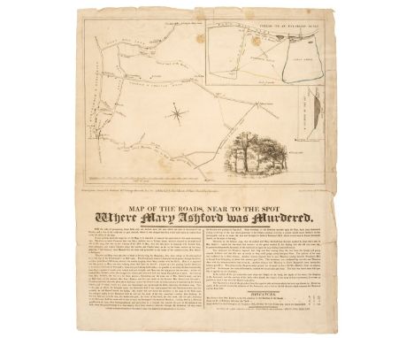
Murder Map. Radclyffe (W & T), Map of the Roads, near the spot where Mary Ashford was Murdered, Surveyed by Rowland Hill & George Moorcroft and published by Rowland Hunter, 1817, engraved broadside map with two insets, one of the 'Fields on an Enlarged Scale', the other 'A Section of the Pit', descriptive text below the map, old folds, slight staining, some marginal fraying closed tears, some tears crudely repaired on the verso, 440 x 370 mmQTY: (1)NOTE:Rare. Only two copies were found on COPAC (both in the British Library). The only known published map by Rowland Hill, the founder of the 'Penny Post'. A murder of a pretty young girl had taken place near his school, at Erdington, a few miles northeast of Birmingham. The circumstances had produced much newspaper coverage but no adequate map to inform the public of the all-important topographical context. Hill measured all the features that had been mentioned in the trial and produced the above map.Mary Ashford had gone dancing on the evening of 26 May at the ominously named Tyburn House (right of centre on Hill's map). There she met Abraham Thornton, the son of a local landowner, and left the dance in his company. Her battered body was discovered the following morning in the pit (shown in cross-section as an inset on the map). A post-mortem showed that she had been raped and that she had been a virgin. Thornton was immediately arrested and charged with Mary's murder. At his trial, several witnesses testified that they had seen Thorton walking along another road at the time of the murder and the prosecution had no witnesses to counter these testimonies. The jury acquitted him; however, local and national opinion regarded Thornton as the murderer and an old law was dug up to see him face justice again. It was the ancient custom of “appeal of murder,” which was evoked by Mary’s brother, William and Thornton once again found himself arrested. However, this old law of “appeal of murder” meant that, instead of a trial in front of a jury, Thornton would face a “trial by combat.” Thornton was by all accounts a large solidly built man, whereas William was small and slight and understandably, declined to fight, and Thornton was released again. Thornton was widely regarded by the general public as guilty, and in the face of increasing harassment, he left England and settled in America. The only positive to come out of the case was that parliament almost immediately abolished the law which allowed 'trial by combat' for the 'appeal of murder'.
WWI. A large collection of WWI reference & related, including Military Operations France and Belgium, 10 vols including 3 map boxes. A mix of conditions and editions. 1915 vol II Map box with 11 maps, as published (Macmillan), maps VG, clean and with just minor wear, the box is damaged and faded. 2 further map boxes: 1917 & 1918 Battery Press and Imperial War Museum). Gallipoli vol II, 1932. Ex-library, poor. The Canadians in France 1915-1918, 1920 1st ed. (Steele/Fisher Unwin). No dust wrapper. Small chip to the head of the spine. Clean internally.Bristol and the Great War 1914-1919, 1920 1st ed. (Stone, Wells/Arrowsmith). No dust wrapper. VG clean copy.Good-Bye To The Battlefields: To-Day and Yesterday On The Western Front, 1928 1st ed. (Taylor/Stanley Paul) No dust wrapper. Darkening to spine and boards, some water damage to the rear board, together with a Field Service Pocket Book 1913. Original brown oil cloth with flap and pocket to front. What makes this item interesting is the extensive notes made throughout the book, and on 2 sheets of A4 by a Capt.L (P) Evans, concerning the Expeditionary Force and other matters. Whether these notes were purely for training purposes, or for actual deployment isn't clear. But it would be of great fascination to an historian or collector of the period. The book itself is well used and scuffed to the edges; the binding is still good, there's a little spotting to the endpapers and there are many notes and annotations throughout. A further large selection of books on The Great War including may rare items.Approximately 160 volumes 6 shelves plus 3 boxes.QTY: (6 shelves & 3 cartons)
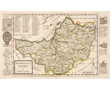
Moll, (Herman). A Set of Fifty New and Correct Maps of England and Wales &c. with the Great Roads and Principal Cross-Roads &c. Shewing the Computed Miles from Town to Town. A Work long wanted, and very useful for all Gentlemen that Travel to any Part of England..., Sold by H. Moll, Tho. & J. Bowles,1724, double-page engraved letter-press title, fifty engraved maps with bright contemporary outline colouring, each map surrounded by uncoloured engraved vignettes of antiquities, each map with a small manuscript number to the margins on the verso and recto, very occasional staining, book plate of R. H. Johnstone, modern quarter calf with a gilt morocco contrasting label to the spine, retaining the contemporary boards, some wear to the extremities, 4toQTY: (1)NOTE:Chubb CLXI. An unrecorded intermediate state, lacking the bracketed numbers normally found on the 2nd state.
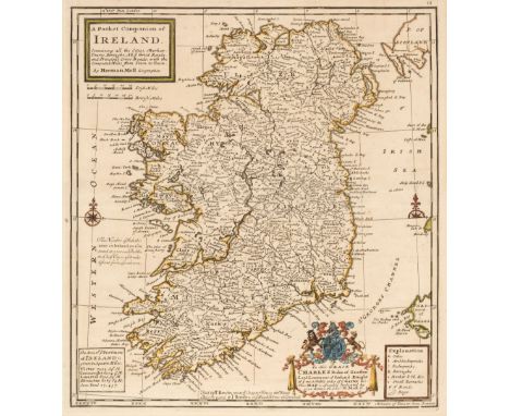
* Moll (Herman). A Pocket Companion of Ireland Containing all the Cities, Market Towns, Boroughs..., A New and Correct Map of Scotland & the Isles..., [and] A General Map of Great Britain and Ireland with part of Germany, Holland, Flanders, France &c..., [1740], together three engraved maps, all with contemporary outline colouring, each approximately 305 x 280 mm, all mounted, framed and glazed, together with Saxton (Christopher & Kip Willem). Mongomery comitatus qui olim pars Ordovicum (3 copies) & Brecknoc comitatus pars olim Silurum [1610 - 37], together four hand-coloured engraved maps, some dust soiling, one map (Montgomery) torn with slight loss, some fraying to margins, each approximately 270 x 320 mm, with Morden (Robert). Glocestershire, circa 1701, hand-coloured engraved map, old folds, 160 x 205 mm, mounted, framed and glazed, plus Owen (John & Bowen (Emanuel). Glocestershire, A Map of Hampshire [and] Bedfordshire [1720 or later], together three hand-coloured engraved maps, each approximately 185 x 120 mm, mounted, framed and glazed, and five hand-coloured engraved strip road maps from the same source, all framed and glazedQTY: (16)NOTE:The first map described. Andrew Bonar Law. The Printed Maps of Ireland, number 67 state 5.
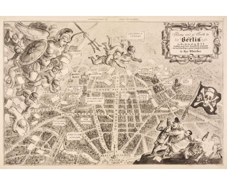
Whistler (Rex). Flying Visit of Truth to Berlin in the form of an R. A. F. leaflet raid here fancifully depicted - but not forgetting a great many hard facts, The Illustrated Magazine, December 9th, 1939, black and white satirical map of an aerial view of Berlin, with descriptive text "What the R. A. F. sees over Berlin" on the verso, 325 x 485 mmQTY: (1)NOTE:The map commemorates the first British "nickel" (propaganda leaflet raid) over Berlin during World war II. It took place in early October 1939 and was carried out by planes of RAF10 Squadron. The raid was promoted as a sign of Germany's weak air defences and its vulnerability to attack. The R. A. F. is represented by numerous putti wearing flying helmets and goggles and being led by a warlike Britannia. In the lower right corner are caricatures of Hitler, Goebbels and Goering, shaking impotent fists at the sky whilst Von Ribbentrop cowers beneath a table. They support a 'skull and crossbones' flag with the skull wearing an SS cap. Rex Whistler joined the army in 1939 but was killed in action in 1944 in Normandy at the age of 39.
Travel & Topography. 25 volumes of mostly 19th-century travel & topography reference, including Nineveh and its Remains: with an Account of a Visit to the Chaldaean Christians of Kurdistan, and the Yezidis, or Devil-Worshippers; and an Enquiry into the Manners and Arts of the Ancient Assyrians, 2 volumes, by Layard, 3rd edition, London: John Murray,1849, some minor toning & spotting, small tear to the margin of the folding map to volume1, original uniform cloth, boards & spines slightly rubbed, spine lightly faded with some minor loss to head & foot, 8voTravels in New Zealand: with contributions to the geography, geology, botany and natural history of that country, 2 volumes, by Dieffenbach, 1st edition, London: John Murray, 1843, 2 monochrome frontispieces, some light spotting, original uniform embossed & gilt decorated green cloth, spines slightly faded, some light rubbing & marks, 8vo Incidents Of Travel In Central America, Chiapas And Yucatan, 2 volumes, 1st edition, by Stephens, London: John Murray, 1841, monochrome map with small marginal tear & plates, some toning & spotting throughout, original uniform gilt decorated brown cloth, spines slightly rubbed & chipped, 8voNarrative of a Voyage Round the World: Performed in Her Majesty's Ship Sulphur. During the Years 1836 - 1840: Including Details of the Naval Operations in China, from Dec. 1840 to Nov, 2 volumes, by Belcher, London: John Murray, 1841,lacking a map to volume 1, some minor toning & marks, contemporary uniform cloth, rear board of volume 1 is detached with damp stains, 8vo, together with a further selection of travel and topography reference, all original cloth, 8voQTY: (25)
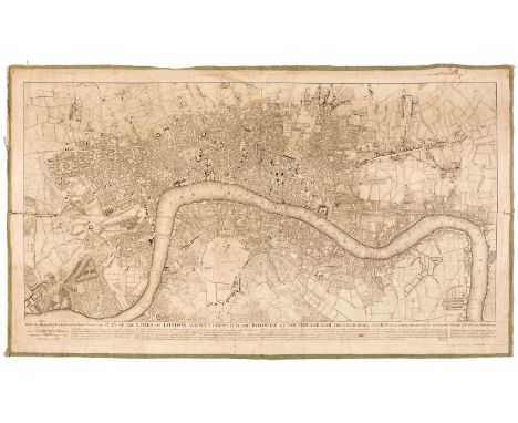
London. Rocque (John), To Martin Folkes Esq. President of the Royal Society: This Plan of the Cities of London and Westminster and Borough of Southwark, with the Contiguous Buildings..., Sold by John Pine & John Tinney, 20th May 1749, uncoloured map engraved by Issac Basire and R. W. Seale, laid on linen and edged with green linen, old folds, slight creasing, slight spotting and staining, some marginal fraying, short splits along the plate mark and old folds, 510 x 900 mmQTY: (1)NOTE:J. Howgego. The Printed Maps of London, number 100, state 1. A Reduction of John Rocque's 24-sheet map of London published in 1746.
Gloucestershire. Speed (John), Glocestershire contrived into thirty thre severall hundreds & those againe into foure principall devisions. The citie of Glocester & Bristowe discribed with the armes of such noble men as have bene dignified with ye titlles of Earles & Dukes thereof, Thomas Bassett & Richard Chiswell, [1676], hand coloured engraved map, inset town plans of Gloucester and Bristol, slight marginal fraying and occasional closed tears, some marginal tape staining, slight creasing, light overall toning, 385 x 515 mm, English text on verso, together with Greenwood (C & J). Map of the County of Gloucester from actual Survey..., 1831, engraved map with bright contemporary wash colouring, calligraphic title, compass rose, table of explanation, table of reference to the hundreds, and an uncoloured vignette of Gloucester Cathedral, 620 x 710 mm, with Morden (Robert). Glocestershire [1695 or later], hand-coloured engraved map, 345 x 415 mm, with another copy similar, plus Moll (Herman). Glocestershire, circa 1724, hand-coloured engraved map, the vertical margins decorated with antiquities, 195 x 315 mm, with another copy similar, and Van den Keere (Pieter). Glocestershire, circa 1627, hand-coloured engraved map, some browning to the margins, 85 x 125 mm, with another seven maps of Gloucestershire, including examples by or after Cary, Badeslade & Toms, Owen & Bowen, Archer, J & C Walker, Phillips and Harrison, various sizes and condition QTY: (14)

British Isles. Lotter (Mathais Albrecht), Le Grande Bretagne ou les Royaumes D'Angleterre et D'Ecosse comme aussi le Royaume D'Irlande Divisé par Provinces..., T. C. Lotter, Augsburg, circa 1776, engraved map with contemporary wash colouring, large uncoloured allegorical cartouche and an inset heraldic device showing the arms of England, Scotland and Ireland, slight staining, 490 x 580 mm, together with Lotter (Tobias Conrad). Britanniae sive Angliae Regnum tam secundum prisea Anglo-Saxonum Imperia..., circa 1756, engraved map with contemporary wash colouring, large uncoloured allegorical cartouche, 580 x 495 mmQTY: (2)
Plot (Robert). The Natural History of Oxfordshire, being an Essay toward the Natural History of England, Oxford: Printed at the Theater, 1677, imprimatur leaf, engraved illustration to title, folding engraved county map, 16 engraved plates, occasional toning, light damp stain mostly to lower margins, later endpapers with armorial bookplate of George Bowden to upper pastedown, contemporary calf, morocco reback with earlier title label relaid, corners repaired, board edges worn, folioQTY: (1)NOTE:Upcott p.1069.

Map Game. England & Wales. Wallis's Tour Through England and Wales, A New Geographical Pastime, London: John Wallis, 24th December 1794, engraved map with contemporary hand-colouring, sectionalised and laid on linen, two columns of rules and town descriptions to left and right margins, lightly finger and dust-soiled, some worming to the left-hand column of text, QTY: (1)NOTE:The printed label on the slipcase is dated 1802. Wallis did reissue this game in 1802 (See Whitehouse page 9.). However with this example, he is probably using up the remaining sheets of the 1794 issue, but in a new slipcase to give the appearance of being up to date (in actual fact there is no difference between the two issues other than the date alteration.) An early board game requiring the players to move counters around the game and to 'visit' various towns and cities. The game is completed at London.
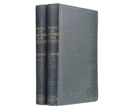
Newton (Charles Thomas). Travels and Discoveries in the Levant, 2 volumes, 1st edition, London: Day & Son, 1865, folding map frontispiece to each, 39 plates (including 12 lithographs, 7 folding maps and plans), some plates etched after photographs by Colnaghi and Spackman, further woodcuts in text, occasional heavy spotting and foxing, small reference numbers in pen to front pastedowns, original blindstamped green cloth gilt, minor marks, ink shelf mark numbers to spines, 8voQTY: (2)NOTE:Atabey 869; Blackmer 1193; Gernsheim, Incunabula of British Photographic Literature, 284.Newton was Vice-Consul at Mitylene and resident in the Levant from 1852 to 1859. This work contains accounts of the excavations of the Mausoleum at Halicarnassus and at Kalymnos.
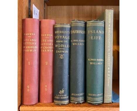
Darwin (Charles). A Naturalist's Voyage, Journal of Researches into the Natural History and Geology of the Countries visited during the Voyage of H.M.S. 'Beagle' round the World, London: John Murray, 1889, engraved portrait frontispiece, few wood engraved illustrations, 4 pp. publisher's advertisements at rear, original dark green cloth gilt, 8vo, together with:Wallace (Alfred Russel), Darwinism, An Exposition of the Theory of Natural Selection with some of its Applications, reprinted, London: Macmillan and Co., 1889, photogravure portrait frontispiece (spotted), folding colour lithograph map, wood engraved illustrations, original dark green cloth gilt, 8vo,Wallace (Alfred Russel), Island Life or the Phenomena and Causes of Insular Faunas and Floras including a revision and attempted solution of the problem of Geological Climates, 2nd edition, revised, London: Macmillan and Co., 1892, hand-coloured lithograph map frontispiece, wood engraved maps and plans, advertisement at rear, occasional scattered spotting, original green cloth gilt, 8vo, plus Darwin (Francis), The Life and Letters of Charles Darwin, 2 volumes, New York: D. Appleton and Company, 1898, monochrome portrait frontispiece to both volumes, library ink stamp at foot of both titles, modern library cloth, 8vo, and Freeman (R. B.), The Works of Charles Darwin, An Annotated Bibliographical Handlist, 2nd edition, revised and enlarged, Dawson: Archon Books, 1977, original green cloth, 8voQTY: (6)
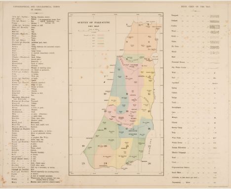
Palestine. Conder (Lieutenants C. R. & Kitchener H. H.), Map of Western Palestine in 26 Sheets, from Surveys Conducted for the Committee of the Palestine Exploration Fund..., During the Years 1872 - 1877 Ordnance Survey Office, 1880, key map and 26 coloured zincographic maps (complete), slight spotting, lacking boards, large oblong folio sheet size 495 x 620 mmQTY: (1)
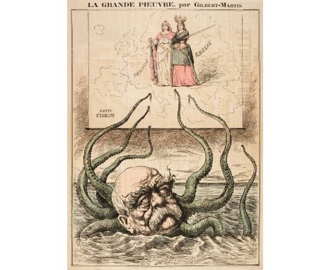
Otto von Bismarck. Gilbert-Martin (Charles), La Grande Pieuvre, published in 'Le Don Quichotte' Magazine, 1888, coloured wood engraved map depicting the German Chancellor as an Octopus reaching out with his tentacles across a wall map of Europe, old folds, 600 x 430 mm, printed text to verso, together with Belloguet (A.). Pilori-Phrénologie - Bismarck 1er. circa 1870, an excoriating coloured lithographic caricature of Bismarck showing him as a vicious and bloody militarist catching all the neighbouring countries of Europe in his spider-like web of deceit and power, sheet size 325 x 230 mm, tipped on to later card, with Grossi (Augusto). L' Orrizzonte Misterioso [and] I Tre Diogeni, circa 1876, two colour lithographic caricatures published in the renowned satirical Italian magazine 'Il Papagallo, slight marginal fraying, each approximately 380 x 565 mm, plus Draner (Jules Renard). L'Homme a la Boule, circa 1870, colour lithographic caricature of Bismarck balancing on the globe, dressed in a circus performer's shorts featuring the Prussian Eagle, sheet size 420 x 290 mm, and La Rana (The Frog magazine, publisher). IL Purgatorio, 1872, colour lithographic caricature, old folds, slight fraying to the margins, 370 x 545 mmQTY: (6)
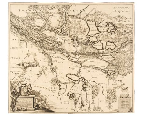
Poland. Berger (J. C.). Delineationem Liberae in Silesia Dynastiae Drachenberg..., Amsterdam, 1676, uncoloured engraved map, decorative cartouche, trimmed to the neat line, central fold strengthened and repaired on verso, repaired marginal closed tear, 510 x 570 mm, Latin text on verso, together with Pitt (Moses). Palatinatus Posnaniensis Majori Polonia Primarii Nova Delinatio per G. F. M. circa 1680, engraved map with contemporary wash colouring, large uncoloured decorative cartouche and mileage scale, 455 x 540 mm, with Homann (Johann Baptist, heirs of). Lusatiae Inferioris..., Nuremberg, 1768, engraved map with contemporary wash colouring, 440 x 555 mm, plus Sanson (Nicolas). Masovie Duché et Polaquie ou sont les Palinats de Czersk, Bielsk et Plocsko, Paris, 1665, engraved map with contemporary outline colouring, 410 x 540 mmQTY: (4)NOTE:The first described item is a scarce map of the Barony of Drachenberg. The map served to aid the civil litigation regarding disputed territory between the Hatzfeld and Nesselrode families whose coats of arms decorate the map. There is a later edition of this map by Petrus Schenk published in 1726.

* Devon. Jansson (Jan), Devoniae Descriptio. The Description of Devon-Shire, Amsterdam, circa 1650, engraved map with contemporary hand-colouring, heightened in silver, some creasing, 380 x 490 mm, mounted, framed and glazed, together with Overton (Henry). Devoniae Descriptio. The Description of Devon Shire, 1713, engraved map with contemporary outline colouring, uncoloured cartouche, heraldic shields and mileage scale, slight staining and spotting, one repaired marginal closed tear, 380 x 475 mm, mounted framed and glazedQTY: (2)NOTE:Kit Batten & Francis Bennett. The Printed Maps of Devon. Henry Overton/Jan Jansson, state 2. John Overton (1640-1713) and his son, Henry, produced a number of atlases and maps from 1665 to 1755. They never possessed a complete set of county map plates and made up their atlases in the early Dutch tradition by using the prints of other publishers, notably the maps of Blaeu and Jansson. Only when these were not available did they arrange for a plate of their own to be produced.John Overton published his 1685 atlas with a very close copy of the Jansson map of Devon. The easiest way to distinguish it from the earlier Jansson plate is the absence of the hyphen between 'Devon' and 'Shire' in the title cartouche. In 1707, John Overton sold his stock to his son, Henry, who revised the map of Devon for the 1713 issue, replacing the Jansson imprint with his own and the date 1713.
Marshall (John, editor). Mohenjo-Daro and The Indus Civilization, being an official account of Archaeological Excavations at Mohenjo-daro carried out by the Government of India between the years 1922 and 1927, 3 volumes, 1st edition, London: Arthur Probsthain, 1931, 164 plates (including folding plans, illustrations after photographs), 2 folding maps to rear pocket of volume 1 (plus an additional large folding map of the region from unrelated work), further smaller illustrations in-text, bookplate of W and P.J. Kupfer to front pastedowns, plate V neatly repaired to upper margin, original publisher's pictorial brown buckram gilt, a few light marks, folioQTY: (3)NOTE:An excellent set of this pioneering work on Mohenjo-Daro (meaning 'Valley of the Dead Men'), the largest settlement of the Indus Valley Civilisation. Located in Sindh, Pakistan, it is one of the earliest known large cities, founded in the 26th century BCE. Marshall's 'announcement in 1924 that he had there found a new civilization of the third millennium marked an epoch in modern discovery; the so-called Indus valley civilization is now recognized as the most extensive civilization of the preclassical world' (ODNB). His 'mass excavation of large areas at Mohenjo-daro . published in 1931, showed a great city, dating from before and after 2000 BC, planned and drained on a vast scale and in a regimented fashion, with wide thoroughfares and closely built houses and workshops. Detail was lost; but, like Schliemann before him, Marshall got to the heart of the matter and gave what was needed first in the current state of knowledge, namely the general shape, the sketch, of a hitherto unknown civilization. He was a pioneer of a high order' (Ibid).
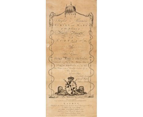
Taylor (George, & Skinner, Andrew). Taylor & Skinner's Survey and Maps of the Roads of North Britain, or Scotland, 1776, engraved calligraphic title with some staining and toning, index and a list of the 'Stages on the Great Road', general map of Scotland with a repaired handling tear, 61 (complete) uncoloured engraved strip road maps, each displayed in triple columns, all but one printed back to back, old soft folds, some staining and dust soiling, last map with several marginal closed tears, later cloth, some wear, spine frayed and partially lacking, oblong 4to, binding size 520 x 235 mmQTY: (1)
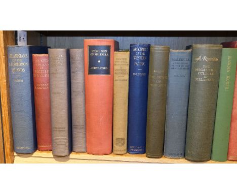
Ivens (W.G.). Melanesians of the South-East Solomon Islands, 1st edition, London: Kegan Paul, Trench, Trubner & Co., 1927, colour and half-tone illustrations, a few minor spots, small ownership ink stamp, original cloth, spine slightly faded, 8vo, together with Landtman (Gunnar). The Kiwai Papuans of British New Guinea, 1st edition in English, London: Macmillan and Co., 1927, map frontispiece, half-tone illustrations, advertisement leaf at end, some light spotting, top edge gilt, original red cloth gilt, spine and extremities a little faded, 8vo, plus Malinowski (Bronislaw). Coral Gardens and their Magic. A study of the methods of tilling the soil and of agricultural rites in the Trobriand Islands, 2 volumes, 1st US edition, New York: American Book Company, 1935, illustrations, some light spotting, original blue cloth gilt, spines faded, 8vo, with other ethnographical and South Seas related including W.G. Ivens' The Island Builders of the Pacific, 1930, A. Bernard Deacon's Malekula. A Vanishing People in the New Hebrides, 1934, John Layard's Stone Men of Malekula, 1942, Tainui. The Story of Hoturoa and his Descendants, by Leslie G. Kelly, 1949, and Argonauts of the Western Pacific, by Bronislaw Malinowski, 4th impression, 1953QTY: (57)

* Oxfordshire. Speed (John), Oxfordshire described with ye Citie and the Armes of the Colledges of ye famous University, Thomas Bassett & Richard Chiswell, [1676], hand-coloured engraved map, inset town plan of Oxford, the vertical margins decorated with 18 heraldic shields of university colleges, slight staining to the central fold, central fold partially strengthened on verso, 385 x 525 mm, mounted, framed and double-glazed, English text on versoQTY: (1)
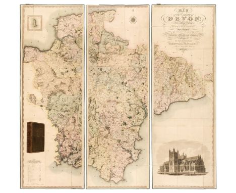
Devon. Greenwood (C. & J.), Map of the County of Devon from an Actual Survey, made in the Years 1825 & 1826..., Greenwood, Pringle & Co. 1827, large scale engraved map, sectionalised and laid on linen, contemporary wash colouring on three sheets, inset map of Lundy Island, calligraphic title, inset uncoloured vignette of a North West View of Exeter Cathedral, table of explanation and compass rose, each sheet edged in green silk, each sheet approximately 1930 x 640 mm, green card endpapers, bookplate of R. H. Johnstone, contained in a contemporary morocco gilt book box, slight wear to extremitiesQTY: (1)NOTE:Batten & Bennett. Printed Maps of Devon, number 96.

Carey (H. C & Lea I.). A Complete Historical, Chronological and Geographical American Atlas, being a Guide to the History of North and South America and the West Indies Exhibiting an Accurate Account of the Discovery, Settlement and progress of their various Kingdoms, States, Provinces &c. together with the Wars, Celebrated Battles and Remarkable Events to the Year 1822, 1st edition, Philadelphia, 1822, letterpress title, advertisement and contents list, the contents list with a small ink stain, 54 (complete as list) numbered double-page engraved map sheets, charts and letterpress tables, contemporary wash colouring, the appendix to the map of Hispaniola torn with a small area of loss to the lower margin, but not affecting the printed image, endpapers toned and creased, contemporary mottled calf, gilt decorated spine, bumped and rubbed at extremities, folioQTY: (1)NOTE:The contents include 46 double-page maps, 2 comparison plates of mountains and rivers, with the remainder being single and double-page tables. The contemporary binding and the contents are in unusually fine unmarked condition.


* Jamaica. Bowles's New Pocket Map of Jamaica, Divided into its Parishes &c. from the Actual Surveys of Sheffield and Others, Carington Bowles, circa 1770, engraved map with contemporary wash colouring, inset map of Port Royal, 485 x 560 mm, mounted, framed and glazed, together with Kap (Capt. Kit S.). The Printed Maps of Jamaica up to 1825, The Bolivar Press, Jamaica, 1968, numerous black and white illustrations, publisher's red stiff paper covers, lacing spine, covers a little faded, slim 8voQTY: (2)
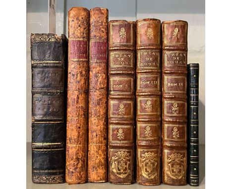
Misson (Henri, de Valbourg). Memoires et observations faites par un voyageur en Angleterre..., La Haye: Henri van Bulderen, 1698, additional engraved title, letterpress title in red and black (imprint date cropped at foot), folding engraved map and folding plan of London, 17 engraved plates (15 folding), browning mostly to text leaves, occasional damp stains to upper margins, armorial bookplate of Henry Thomas Buckle to upper pastedown, all edges gilt, early 19th-century calf gilt, lacking spine labels, joints cracked at head, 12mo, together with:[Nichols, John; Warburton, John & Ducarel, Andrew Coltee], Some account of the Alien Priories, and of such lands as they are known to have possessed in England and Wales, 2 volumes, London: Printed by and for J. Nichols, 1779, folding engraved map frontispiece to first volume, 7 engraved plates (3 folding), closed tear to L8 in volume 1, contemporary speckled calf, red morocco title labels to spines, joints cracked and light wear at head and foot of spine, 8vo,Boursault (Edme), The?atre de feu Monsieur Boursault, 3 volumes, new edition, Paris: Francois Le Breton, 1725, 18th-century continental armorial ink stamp with ducal coronet to titles and final leaves, toning throughout, contemporary calf, gilt decorated spine with continental ducal gilt embossed armorial at foot of spines, 12mo,Phaedrus, Fabulae et Publii Syri Sententiae, Paris: Ex Typographia Regia, 1729, printed on large paper, engraved frontispiece by Simmoneau, early19th-century crushed black half morocco gilt, slim 12mo (Graesse V p.253; Dibdin II p.280)QTY: (7)
Cleveland (John). The Works Mr. John Cleveland, containing his Poems, Orations, Epistles, collected into one volume, with the Life of the Author, London: Printed by R. Holt, for Obadiah Blagrave, 1687, engraved portrait frontispiece frayed to edges, blind stamp to title, 4 pp. publisher's list at rear with small hole to first leaf, browning throughout, occasional spotting to margins, library bookplate to front free endpaper 'The Brother Julian, F. S. C. Collection, donated by Mr. Christian A. Zabriskie, New York City'., late 19th/early 20th-century gilt decorated panelled calf, rebacked preserving spine, morocco labels to spine, 8vo (Wing C4654), together with:Woty (William), The Poetical Works of Mr. William Woty, 2 volumes, London: William Flexney, 1770, browning to margins of first and last few leaves, bookplate of David Rice trees of Llandovery to upper pastedown, contemporary diced calf, both volumes rebacked, board corners worn, 8vo, with another set of the same edition bound in contemporary calf,Norris (John), A Collection of Miscellanies: consisting of Poems, Essays, Discourses & Letters, Occasionally Written, 2nd edition, corrected, London: J. Crosley and Samuel Manship, 1692, imprimatur leaf present, early signature 'Wm. fawconer' at head of title, damp staining at front and rear, old label of Tortworth Rectory to upper pastedown, contemporary speckled calf, worn at head and foot, 8vo,Orrery (John Boyle, Earl of), Remarks on the Life and Writings of Dr. Jonathan Swift, Dean of St. Patrick's, Dublin; in a Series of Letters from John, Earl of Orrery, to his Son, the Honourable Hamilton Boyle, 2nd edition, corrected, London: A. Millar, 1752, engraved portrait frontispiece, contemporary calf, joints cracked, 8vo,[Blackwell, Thomas], An Enquiry into the Life and Writings of Homer, 2nd edition, London: Printed in the Year, 1736, engraved frontispiece, title with engraved vignette, folding engraved map, engraved illustrations, contemporary blind panelled calf, rebacked, joints cracking at head and foot, extremities rubbed, 8vo,Waller (Edmund), Poems, &c. Written upon several Occasions, and to several Persons, 8th edition, with additions, London: Jacob Tonson, 1711, engraved portrait frontispiece, toning and scattered spotting, armorial bookplate of George Rous to upper pastedown, contemporary calf, rebacked, joints and extremities rubbed, 8vo, plus other mostly 18th-century antiquarian, mostly poetry and relatedQTY: (29)

* Prints & Engravings. A collection of approximately 450 engravings, 18th & 19th century, engravings and lithographs, mostly British topographical views, including examples by or after Tombleson, Swarbreck, Colston, Calvert, Radclyffe, Cooke, Stockdale, Shepherd, Le Petit, Tomkins and Lambert, various sizes and condition, together with Hill (T.). View above the Falls of Schuylkill, M. Carey & Son, Philadelphia, circa 1830, uncoloured aquatint after J. Shaw, 300 x 390 mm, with a small collection of late 20th-century topographical watercolours, plus Duncan (E.). To James Weddell Esqr. R. N. The Officers & Seamen under his Command, This plate of the Brig Jane and Cutter Beaufoy on 20th February 1823 bearing up to in 74º. 15´..., J. Huggins 1826 [but 20th-century re-strike), uncoloured aquatint after W, J. Huggins, slight creasing, 400 x 550 mm and a large uncoloured etching by C. Holloway, and The Artist, 22 volumes, a broken run 1931 - 33, numerous uncoloured illustrations throughout, including articles on the etcher Ian Strang, publisher's paper wrappers, some covers detached and frayed, slim folio, with Strang (Frances). Town and Country in Southern France, with drawings by Ian Strang, MacMillan and Co. 1937, additional half-title, numerous black and white illustrations throughout, 'map' endpapers, publisher's cloth gilt, dust jacket chipped and torn with loss, 8voQTY: (approx. 450)
Cary (John). Cary's New and Correct English Atlas: Being a New Set of County Maps from Actual Surveys..., 1st edition, printed for John Cary, Engraver, Map and Print-seller, the corner of Arundel Street, Strand, Septr. 1st 1787, advertisement, dedication and title page, tables of roads and lists of cities and towns, index and list of subscribers, the index with near-contemporary manuscript annotation, 47 (complete as list) engraved maps with contemporary outline colouring, each with a tissue guard, each map with a page of descriptive text, slight staining to the endpapers and pastedowns, contemporary sheep, lacking spine, worn and frayed, 4toQTY: (1)NOTE:Chubb, CCLX. The first edition of Cary's earliest published atlas. This copy with slightly odd pagination.
Cary (John). New British Atlas, Being a Complete Set of County Maps, on which are delineated all the Roads, Cities, Towns, Villages, Rivers & Canals; together with Correct General Maps of England, Wales, Scotland and Ireland, printed for John Stockdale, 1805, calligraphic title (with some staining), index, 50 engraved maps (complete as list), all with contemporary outline colouring, the map of Lancashire torn with loss, crudely repaired, maps of Hampshire and North Riding of Yorkshire trimmed with slight loss to the printed margin, slight worming to the upper margins, some dust and finger soiling throughout, later endpapers, bookplate of R. H. Johnstone, modern quarter calf, slim folioQTY: (1)NOTE:Chubb. CCCXIX.

Naval. A large collection of modern naval & maritime reference, including Naval Operations Vol I, (Maps) to the Battle of the Falklands, 1920 (Corbett). Map box containing all 18 maps. Some wear to the box; the maps are VG. Vol II (Text and Maps). Rebound ex-library with all maps present. Vol I, 1920 (Corbett/Longmans). Ex-library' poor. 2 copies. Naval Leadership and Management 1650 - 1950, by Doe & Harding, Boydell, 2012 The Imperial Japanese Navy, by Jane, Conway, 1984, original cloth in price-clipped dust jacketA Mission of Honour: The Royal Navy in the Pacific 1769-1997, by Mclean, Winter Production, 2010Captain Cook, by McLynn, Yale, 2011, 10 'as new' duplicate copies together with other naval and maritime history, mostly original cloth in dust jackets, G/VG, 8vo/4to QTY: (6 shelves & a carton)

* World. Moll (Herman), A New & Correct Map of the Whole World Shewing ye Situation of its principal parts..., with the Most Remarkable Tracks of the Bold Attempts which have been made to Find Out the Northeast and Northwest Passages..., sold by H. Moll & J. King and printed for John and Thomas Bowles, 1719, large engraved map on a Mercator projection, on three conjoined sheets, contemporary outline colouring and some later enhancement to the cartouche, inset maps of the North Pole and a world map showing the degrees of variation, insular California, old folds, slight wear to old folds, slight overall toning, 710 x 1210 mm, mounted, framed and glazedQTY: (1)NOTE:One of the largest world maps to ever appear in an atlas. The borders of the map are filled with comments by Moll as well as an advertisement in which he advises his clients not to subscribe to 'inferior' works such as those by Moses Pitt.
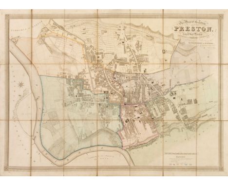
Lancashire. Myers (J. F.), This Map of the Town of Preston from Actual Survey completed in the Year 1836 is by permission respectfully dedicated to the Mayor, Alderman & Burgesses..., 1836, large scale map with contemporary wash colouring, sectionalised and laid on linen, calligraphic title, compass rose and table of explanation, slight staining, some dust soiling, 815 x 1130 mm, bookplate of D. B. Anderson, bound in contemporary calf boards with circular gilt title to the upper siding, worn and frayed at the extremities, binding size 295 x 180 mm, together with Tunnicliff (William). A Survey of the County of Lancaster, circa 1790, uncoloured engraved folding map, title page and 118 pages of descriptive text, with 16 pages of heraldic shields bound at rear, partially uncut, later endpapers, bookplate of D. B. Anderson, modern half calf gilt, slim 8voQTY: (2)

British Pictorial City Maps. Seven Pictorial Maps, early 20th century, including, Bullock (L. G.). Pictorial Plan of Glasgow, John Bartholomew & Son, Ltd. Edinburgh, 1937, colour lithographic pictorial map (published to coincide with the Scottish Empire Exhibition), old folds, a few folds strengthened and repaired on verso, publisher's printed card wrappers, 600 x 895 mm, together with A Pictorial Map & Notes on the Historic City of Bath, Edward Everard, Bristol, circa 1950, colour lithographic pictorial map, old folds, some wear where old folds cross, a few folds strengthened and repaired on verso, 715 x 520 mm, descriptive text on verso, with Parry (G. H.). Map of Merseyside with Historical and Literary Allusions, Philip Son & Nephew Ltd. 1934, colour lithographic pictorial map, old folds, slight wear where old folds cross, 485 x 745 mm, publisher's printed boards, plus Sleigh (Bernard). A Picture Map of Birmingham in 1730. Imagined and Drawn from City Records, Kynoch Press, 1924, colour lithographic pictorial map, 325 x 480 mm, and G. Falkner & Sons (publishers). Port of Manchester, The Dock, Estate & Trafford Park Estate showing the Dock System, Established Industries and Areas Ready for Development, circa 1926, colour lithographic pictorial map, old folds, backed with archival paper, 230 x 480 mm, with Manchester Guardian (publisher). The Most Populated Area in the World [and] Civic Week Map of Manchester. circa 1926, two small lithographic pictorial maps of Manchester, 175 x 135 mm and 195 x 295 mm respectively, both with descriptive text on verso QTY: (7)

Boucher (Lucien, 1889 - 1971). Air France. Sur les Ailes d'Air France Decouvrez le Monde a Votre Tour, printed by Perceval, Paris, circa 1950, colour photolithographic map of the world produced for Air France, old folds, some creasing, three repaired marginal closed tears affecting the printed image, slight spotting and water staining, largely confined to the margins, 615 x 960 mm, presented on contemporary pine battensQTY: (1)NOTE:Lucien Boucher produced a series of promotional posters for Air France throughout the middle of the 20th century. The map shows the world on a hemispheral projection with an allegorical representation of the four continents in each corner. His clever designs manage to give the suggestion of a blend of fantasy and reality and at the same time provides the viewer with a suggestion of the experience they will have if they choose to fly with Air France. It is designed to capture the imagination and at the same time provide a strong brand message.

Map Game. Richardson (W.), The Mount of Knowledge, also sold by Darton & Harvey, J. Harris & J. Wallis, circa 1820, engraved linear game with contemporary hand colouring, sectionalised and laid on linen, slight worming, 475 x 480 mm, supplied with a contemporary six sheet book of rules and contained in contemporary card slipcase with printed label to the upper cover, slipcase with very slight wear to the extremities, QTY: (1)NOTE:Rare. We could only find one institutional copy (V & A). A copy was offered for sale by Francis Edwards in 1977.

Labillardiere (Jacques Julien Houten de). Atlas pour Servir à la Relation du Voyage à la Recherche de la Pérouse fait par ordre de L'Assemblée constituante pendant les années 1791, 1792, et pendant la 1ere. et 2eme. année de la République Francaise..., 1st edition, Paris: H.J.Jansen, in the 8th year of the Republic, [1799-1800], engraved title page, folding engraved route map at rear and forty-three uncoloured engraved plates of ethnological, botanical and ornithological interest, some damp staining and occasional spotting, fraying to fore-margins of title and few other plates, 19th-century cloth-backed marbled boards, spine and board corners worn, folio (51 x 33.5 cm)QTY: (1)NOTE:Ferguson 308; Hill 954; Nissen ZBI 2331; Sabin 38420.
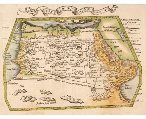
North Africa. Fries (Lorenz), Tabula IIII Affri, 1st edition, J. Gruninger, Strasbourg, 1522, woodblock map with early but crude hand colouring, title in a ribbon cartouche above the map, large margins, slight staining, spotting and creasing, lower margin strengthened on verso, 340 x 460 mm, Latin text on verso set within ornate engraved borders including a vignette of an elephant by a waterhole allowing a baby to play with its trunk whilst the apparently unconcerned child's mother looks on.QTY: (1)NOTE:Norwich 287: "The origin of the Nile conforms to the Ptolemaic tradition and the seated figure below Ethiopia is undoubtedly that of the mythical Prester John".

[Hennepin, Louis. A New Discovery of a vast Country in America, Extending above Four Thousand Miles, between New France and New Mexico. With a Description of the Great Lakes, Cataracts, Rivers, Plants, and Animals], 2 volumes in 1, 2nd edition, London: Printed for H. Bonwick at the Red Lion, 1699, lacking engraved title and both maps (maps provided in facsimile, portion of one map surviving), 6 engraved folding plates present, spotted and toned, recased with contemporary mismatched calf laid down (endpapers and blanks renewed), contemporary red morocco title label lettered in gilt to spine, joints worn, 8voQTY: (1)NOTE:Sabin 31372; Wing H1452.

Napoleonic. A large collection of 19th-century & modern Napoleonic reference, including Histoire du Duc de Wellington, 3 volumes, by Brialmont, French language edition, Charles Tanera, 1856, folding maps, contemporary half calf, 8voThe Campaign of 1815, Chiefly in Flanders, 1st edition, by James, Blackwood & Sons, 1908, map to the rear pocket plus other folding maps & plans, the top section of the half-title has been removed & a newspaper cutting has been tipped in to a blank page, contemporary binding, slightly rubbed to head & foot, 8vo A History of the Peninsula War, reprint of the 1902-30 edition, 7 volumes, by Oman, AMS, 1980, all original cloth, 8vo, together with other Napoleonic reference & related, some leather bindings, some original cloth, G, 8voApproximately 115 volumes QTY: (6 shelves)
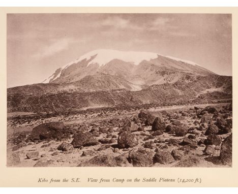
Meyer (Hans). Across East African Glaciers, an account of the first ascent of Kilimanjaro, 1st edition in English, London: George Philip & Son, 1891, chromolithograph frontispiece, 12 black & white lithographed plates, 8 mounted photographs, 3 folding maps, a few preliminary gatherings (including frontispiece, title, first folding map) loose, a preliminary leaf with large tear (no loss), front hinge cracked, original green pictorial cloth gilt, some wear, 8voQTY: (1)NOTE:Neate M92; Perret 2987.A highly important account of the first ascent of Kibo, the highest of Kilimanjaro's two peaks.
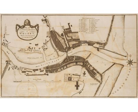
Young (George). A History of Whitby, and Streoneshalh Abbey; with a Statistical Survey of the Vicinity to the Distance of Twenty-Five Miles, 2 volumes, Whitby: Printed and sold by Clark and Medd, 1817, uncoloured aquatint frontispiece to volume 1 and folding engraved map frontispiece to volume 2, 15 engraved/etched plates and plans (including 5 folding, some offsetting, few neat repaired closed tears to folding plans), wood engraved illustrations to text, one folding table, subscribers list, occasional spotting, modern cloth hinges to endpapers, contemporary marbled calf, rebacked, 8vo, together with:Bewick (Joseph), Geological Treatise on the District of Cleveland, in North Yorkshire, its Ferruginous Deposits, Lias, and Oolites; with some observations on Ironstone Mining, London: John Weale; Newcastle-on-Tyne: Andrew Reid, 1861, 2 folding colour lithograph sectional plans, 2 double-page colour lithograph mine plans, 2 folding tables and large folding colour lithograph map contained in rear pocket, some toning and occasional spotting, 20th-century cream/fawn half calf, spine darkened and some mottling, 8vo,Tate (Ralph & Blake, John Frederick), The Yorkshire Lias, London: John Van Voorst, 1876, advertisement leaf, half-title, 19 lithograph plates, and loosely inserted hand-coloured engraved map, front endpaper with visitors/calling card of Rev. J. F. Blake of Clifton, York to front pastedown, hinges split, original cloth, joints and extremities worn, 8vo,[Hall, George], The History of Chesterfield; with particulars of the Hamlets contiguous to the Town, and descriptive accounts of Chatsworth, Hardwick, and Bolsover Castle, London: Whittaker and Co.; Chesterfield: T. Ford, 1839, engraved frontispiece, additional title and numerous plates, light toning and occasional spotting, top edge gilt, later half calf by Hatchards, gilt decorated spine, 8voQTY: (5)
Lyell (Charles). Principles of Geology, being an attempt to explain the former changes of the Earth's surface, by reference to causes now in operation, 3 volumes, 2nd edition of volumes 1 and 2, 1st edition of volume 3, 1832-33, half-title to volume 3 only, 2 hand-coloured aquatint plates, 6 uncoloured engraved plates (light damp stain to margins of vol. 1 frontispiece), and 3 maps (2 hand-coloured and 2 folding, also includes a duplicate map 'of extent of surface in Europe' from another edition), numerous wood engravings to text, publisher's adverts at rear of each, occasional offsetting and scattered spotting, contemporary half calf with contrasting labels to spines, extremities lightly rubbed, 8voQTY: (3)NOTE:PMM 344; Dibner 96; Grolier/Horblit 70; Milestones of Science 140; Norman 1398 [all for first edition].A foundational text of modern science and a central influence on the theory of evolution. Lyell demonstrated that large-scale changes in the Earth's physical geography could be explained by uniform geological causes which could be seen in the present day, rather than by catastrophic or biblical events. The implications of Lyell's study would have a profound effect on the development of evolutionary theory. Charles Darwin read the work on his voyage with The Beagle and it greatly influenced his thinking on both geology and evolution. A second edition of the third volume was not published.
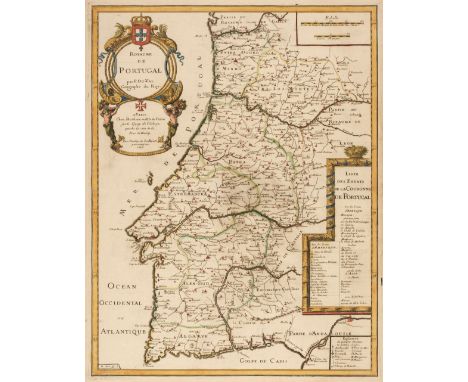
Portugal. Du Val (Pierre), Royaume de Portugal, W. Michu, Paris, 1676, engraved map with contemporary outline colouring, large decorative cartouche, slight marginal staining, 545 x 425 mm, with another copy similar, together with Homann (Johann Baptist, heirs of). Regni Portugalliae Provicias tres Septentrionales Beiram, Transmontanam & Interamniam..., [and] Provincias Meridionales Regni Portugalliae Seilicet Extremadura, Transtagana quibus Regnum Algarbiae..., 1800, two engraved maps with contemporary outline colouring, decorative cartouche, titles repeated above the maps in French, some tape staining to the upper margins but not affecting the printed image, each approximately 580 x 465 mm, plus Zatta (Antonio). L'Estremadura di Portogallo Alentejo ed Algarve di Nuova Projezione, Venice, 1775, engraved map with contemporary outline colouring, decorative cartouche with later colouring, 320 x 335 mm, and Seutter (George Matthaus). Portugalliae et Algarbiae Regna..., circa 1720, engraved map with contemporary outline colouring, inset map of Brazil, large uncoloured decorative cartouche, some tape staining to the upper margins but not affecting the printed image, water stained, 500 x 580 mm, with Faden (W.). Chorographical Map of the Kingdom of Portugal Divided into its Grand Provinces..., 1797, engraved map with contemporary outline colouring, light overall toning, slight mount staining, title repeated above the map in Spanish, 750 x 520 mm, with another four maps of Portugal by or after De Vaugondy, Du Val and De Wit, various sizes and condition QTY: (10)

Taylor (Thomas & Blome Richard). England Exactly Described or a Guide to Travellers in a Compleat Sett of Mapps of all the County's of England..., circa 1715, printed title and 39 (only of 42) uncoloured engraved maps, each map trimmed and tipped onto later paper, maps stained and browned with old folds, occasional splits along old folds, bound in a near contemporary album, quarter morocco, re-backed, marbled boards, heavily worn and frayed, oblong 4to QTY: (1)NOTE:Sold as a collection of maps, not subject to return.
British Isles. Carte des trois Royaumes D'Angleterre D'Ecosse et D'Irlande..., 1735, unattributed uncoloured engraved map, based on an earlier map by De L'Isle, decorative cartouche and inset tables of mileage and explanation, old folds, one rust mark, one short repaired marginal closed tear, 465 x 565 mmQTY: (1)NOTE:R. W. Shirley. Printed Maps of the British Isles, 1650 - 1750, Anon. 4. The pagination number in the top right corner would indicate its inclusion in an unidentified publication.

Boucher (Lucien). Air France Réseau Aérien Mondial, Paris, circa 1934/5, chromolithographic world map on a Mercator projection, slight toning and staining to the margins, one skillfully repaired closed tear, some adhesion scaring to the verso, 600 x 975 mmQTY: (1)NOTE:Louis Boucher designed and produced posters for Air France for nearly thirty years and his clever artwork manages to give the suggestion of a blend of fantasy and reality and at the same time provide the viewer with the suggestion of the experience they will have if they choose to fly with Air France. This example is Boucher's first poster for Air France, produced just a couple of years after the company was established and shows the extent of the airline's network around the world.

British Isles. Cary (John). Cary's New Map of the British Isles, exhibiting the Whole of the Turnpike Roads both Direct & Cross, Particularly Distinguishing those on Which the Mail Coaches Travel; the Cities Market and Borough Towns with the Distance from Each Other as Also from the Metropolis..., April 1st, 1815, corrected to 1836, engraved map with contemporary hand-colouring, sectionalised and laid on linen on three sheets, inset maps of the Orkney & Shetland Islands, calligraphic title, slight dust soiling, very occasional staining, edged in green silk, marbled endpapers, if conjoined, the whole measuring approximately 1980mm x 1680mm, contained in a contemporary calf book box, the box heavily worn and frayedQTY: (1)
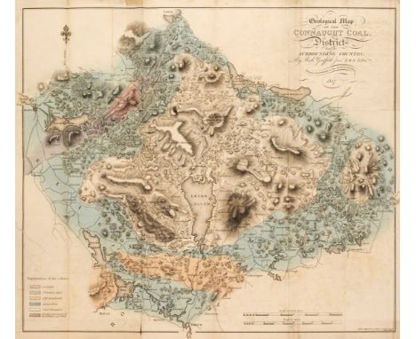
Griffith (Richard). Geological and Mining Survey of the Connaught Coal District in Ireland, Dublin: Graisberry and Campbell, 1818, hand-coloured engraved folding section (some offsetting) and hand-coloured engraved folding map with 8cm repaired closed tear to left-hand, manuscript number to upper margin of title, final leaf of text strengthened to upper margin, some light offsetting, toning and occasional spotting, edges untrimmed, modern cloth-backed boards, 8voQTY: (1)

Geological Map. Walker (J. & C.), A Geological Map of England, Wales and Part of Scotland, showing also the Inland Navigation by means of Rivers & Canals, with their Elevation in feet above the Sea, together with the Rail Roads & Principal Roads, London: J. & C. Walker, March 31st, 1837, folding engraved map sectionalised on linen, with contemporary hand-colouring, 1415 x 985 mm, contained in contemporary dark green cloth-covered book-form box with lid, morocco title label to spineQTY: (1)
Smyth (Charles Piazzi). Tenerife, an Astronomer's Experiment: or, Specialities of a Residence Above the Clouds, 1st edition, London: Lovell Reeve, 1858, half-title, engraved map, 20 original albumen print stereoviews (including frontispiece) tipped in, publishers' advertisements at rear, a little spotting and dust-soiling, library label (with 'Withdrawn' stamp) to front pastedown, original ribbed cloth gilt, rubbed and slightly soiled, frayed at head and foot of spine with some loss at head, old manuscript paper shelf label to lower part of spine, 8voQTY: (1)

Washington. Baker (Benjamin), Plan of the City of Washington; Now Building for the Metropolis of America, and Established as the Permanent Residence of Congress after the Year 1800, W. Bent, 1793, uncoloured engraved city plan, old folds, slight offsetting, one repaired closed tear affecting the printed image, 275 x 345 mmQTY: (1)NOTE:Scarce early plan of Washington DC, published in the Universal Magazine in July 1793. The map is based upon Ellicott's map of Washington, published in 1792 and derives from the so-called Philadelphia Plan, engraved by William Thackeray. The map was circulated in London in an attempt to stimulate overseas investment.
![China. De Jode (Cornelis), China Regnum, Antwerp [1593], uncoloured circular engraved map with an ornate foliate strapwork bo](https://cdn.globalauctionplatform.com/06960e46-dc7c-49b2-836c-b03600e595e8/67907970-a909-4105-ae68-b037011fc70a/468x382.jpg)
China. De Jode (Cornelis), China Regnum, Antwerp [1593], uncoloured circular engraved map with an ornate foliate strapwork border with a roundel to each corner, good margins, slight text show through in the vertical margins, one very small area of strengthening to the central fold on the verso, 360 x 450 mm, Latin text on verso QTY: (1)NOTE:A rare early map of China, that was published in Speculum Orbis Terrae. The map only appeared in one edition of this atlas and WorldCat lists only five institutional copies.
![Bible [English]. [The Bible that is, the Holy Scriptures conteined in the Olde and Newe Testament. Translated according to th](https://cdn.globalauctionplatform.com/06960e46-dc7c-49b2-836c-b03600e595e8/ba8ddf24-5261-4008-a1ef-b03701205c1b/468x382.jpg)
Bible [English]. [The Bible that is, the Holy Scriptures conteined in the Olde and Newe Testament. Translated according to the Ebrewe and Greeke, and conferred with the best translations in diuers languages..., Imprinted at London: By Christopher Barkar, 1576], lacking general title and three other preliminary leaves (of the two preliminary leaves present, one is misbound and the other crudely lined to verso and repaired), New Testament title present with woodcut, Apocrypha present, double-page woodcut plate 'The forme of the Temple and citie restored', leaf after New Testament title with woodcut map to 'The Description of the Holie Land', few woodcut initials, illustrations and plans to text, initial two leaves of Book of Genesis torn at foot with slight loss and crudely repaired to lower margin and fore-margin, some close trimming to few running titles, small hole to 2T6, long closed tear to 2X3, 2X4 and 5P6, two small holes to 5E2 affecting few letters of text, bound with Book of Psalms The Whole Booke of Psalmes, collected into Englishe meter by Thomas Sternh. John Hopkins and others..., Imprinted at London by John Day, 1576, title within woodcut border, light toning, minor damp stains, occasional scattered spotting and marks, endpapers renewed, near contemporary calf covered lower board with gilt decorative motives to centre, modern brown morocco upper board and spine, original spine with 19th-century maroon morocco title label preserved, small folio (25.7 x 17.7 cm)QTY: (1)NOTE:Darlow & Moule 107; Herbert 144; STC 2118. There are two small folio editions of this date, which, while closely resembling one another, are yet quite distinct. The Bible in this lot is version B.
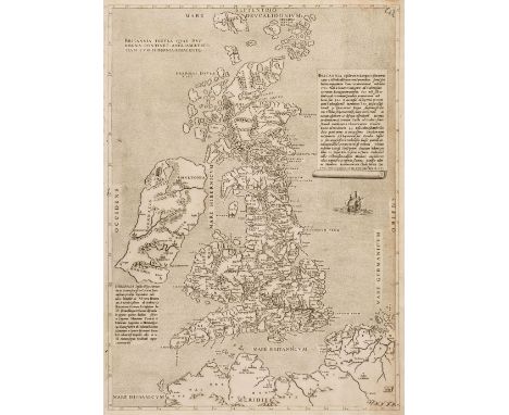
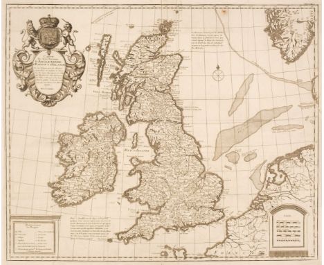
British Isles. Lafreri (Antonio, school of), Britannia Insula quae duo Regna Continet Angliam et Scotiam cum Hibernia Adiacente, Rome, circa 1556, uncoloured engraved map (usually credited to Claudi Duchetti) the title in block text to the upper left, the map is based on George Lily's earlier map of 1546, two blocks of descriptive text, right-hand vertical margin trimmed with loss to the printed margin, skillfully replaced in facsimile, the horizontal margins trimmed to the neat line with the 'Septentrio' and 'Meridies' cardinals excised from the margins and tipped on to the map, 485 x 350 mm QTY: (1)NOTE:R. V. Tooley. Early Printed Maps of the British Isles, number 60a. The second state of this map with 'Mare Hisranicum' corrected to 'Mare Hispanicum'. Rare.Ashley Baynton Williams: The reason that Lafreri's name is now used as an umbrella term for the school is because he issued a catalogue of his stock in 1572, entitled 'Indice Delle Tavole Moderne Di Geografia Della Maggior Parte Del Mondo ...'. This catalogue is very similar, both in title and contents, to bound collections of maps with an engraved title Tavole Moderne Di Geografia De La Maggior Parte Del Mondo Di Diversi Autori. Accordingly bound collections with the engraved title were attributed to Lafreri, and thence his name became associated with the group as a whole. Some writers have attributed the title to Duchetti, but there seems no good reason to challenge Lafreri's role.

England & Wales. A collection of thirty- six maps, 18th & 19th century, engraved and lithographic maps, many with hand-colouring, including examples by or after Zatta, Stukeley, Horsley, Harrison, Hooper, Hutchinson, Brion de la Tour, Barbié du Bocage, Blair, Clouet, Euler, De Vaugondy, Bowen (Emanuel), Wells, Pigot, Slater, Dyonnet, J & C Walker, Davies, Cary, Faden, Neele, Neele/Pinkerton, Mogg, Murray, Johnson, Arrowsmith, Enouy and Moule, occasional duplicates, mostly large format, but various sizes, good condition, together with Barlow (William). England, 17th September 1861, highly detailed pen, ink and watercolour map of England and Wales, slight dust soiling, 445 x 350 mmQTY: (37)
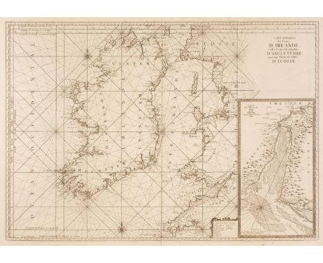
Ireland. Van Loon (Jan), Carte Generale des Costes D'Irlande et des Costes Occidentales D'Angleterre avec une Partie de celles D'Ecosse, [1661 or later], large uncoloured sea chart of Ireland and the west coast of England & Wales, inset map of the River Dee and Chester, compass rose and numerous rhumb lines, 610 x 870 mm, together with Mount (William & Page Thomas). A Chart of the Coasts of Ireland and Part of England, circa 1744, uncoloured engraved sea chart of Ireland and part of the west coast of England & Wales, compass rose and numerous rhumb lines, slight staining, 440 x 540 mmQTY: (2)

Edward Angelo Goodall, RWS, British 1819-1908- Chiuso Fishing Boat at Venice; pencil and watercolour heightened with white on paper, inscribed and dated 'Chiuso Fishing Boat / at Venice Sep 21-1843' (upper right), 22.8 x 35.8 cm. Provenance: with Thomas Agnew & Sons, London, no.30581. Private Collection, UK. Exhibited: London, Thomas Agnew & Sons, no.201. Note: Goodall was a member of a prominent family of artists, including his brothers Frederick Goodall (1822-1904) and Walter Goodall (1830-1889). In 1841, he was sent on an expedition by the Prussian Government to map the boundaries of British Guiana, with his sketches of indigenous people, landscape, and animals now held at the British Library in London. In 1854 he was appointed war artist for the 'London Illustrated News', recording the conflict in Crimea, after which he travelled widely around Europe, visiting Venice 15 times. The present work originates from one of these trips, and demonstrates his ability to capture the scenes around him with an effective sense of immediacy and presence.
-
109198 item(s)/page