We found 109198 price guide item(s) matching your search
There are 109198 lots that match your search criteria. Subscribe now to get instant access to the full price guide service.
Click here to subscribe- List
- Grid
-
109198 item(s)/page


![Military.- Napoleonic wars.- [Sherer (Joseph Moyle)] Recollections of the Peninsula, second edition, half-title, B7 lacking c](https://cdn.globalauctionplatform.com/69cfbae0-6944-4b60-85fd-ab0c00b5d8b9/5180e7c2-080d-45af-8149-ab0c00bba499/468x382.jpg)
Lot 118
Military.- Napoleonic wars.- [Sherer (Joseph Moyle)] Recollections of the Peninsula, second edition, half-title, B7 lacking corner, not affecting text, occasional spotting and finger soiling, later half morocco, a little rubbed, 1824 § Sabine (Major-General Edward) Letters of Colonel Sir Augustus Frazer ... written during the Peninsular and Waterloo Campaigns, presentation copy from Vice-Chancellor Sir William Page Wood, inscribed on half-title, portrait frontispiece, 3 maps, 1 folding, occasional faint spotting, publisher's advertisements bound at end, modern half-morocco, 1859 § Hay (Sir Andrew Leith) A Narrative of the Peninsular War, engraved frontispiece, 19 plates, folding map, bookplate, contemporary calf, 1840 § Dalton (Charles) The Waterloo Roll Call, portrait frontispiece and plates, several short marginal tears, tape repairs, original paper wrappers, rebacked, slight chipping to edges, small tape repair to lower cover, 1890; and c.49 others similar, v.s. (c.53)
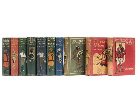
Lot 143
NO RESERVE Henty (G. A.) With Kitchener in the Soudan, 10 plates, maps and plans, spotting to prelims, covers mottled, 1903; The Treasure of the Incas, 8 plates, map, occasional light foxing, ink ownership inscription, some light mottling and marking to covers, 1903; With the Allies to Pekin, 8 plates, map, covers a little mottled, 1904; To Herat and Cabul, 8 plates, map, occasional foxing, ink ownership inscription, covers a little mottled, 1902; With Roberts to Pretoria, 12 plates, map, some light spotting, ink ownership inscription, covers a little mottled, 1902; With the British Legion, 10 plates, light finger-soiling, shaken, 1903, first editions, 32pp. advertisements, original pictorial cloth, spines a little discoloured, spine ends and corners a little bumped, rubbing, [Dartt pp.160, 140, 162, 139 & 163]; and 4 others by the same, 8vo (10)
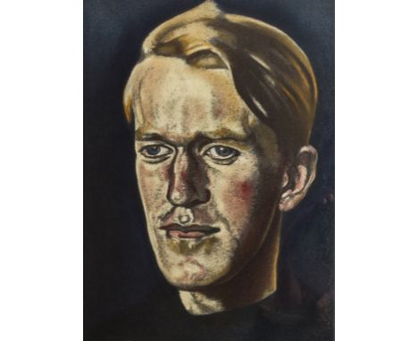
Lot 157
Lawrence (T.E.) Revolt in the Desert, number 239 of 315 large paper copies, colour portrait frontispiece after Eric Kennington, 18 portraits and plates, most after Kennington, W.Roberts and Augustus John, folding map with route in red at end, tissue guards, bookplate of John Albert Jones, original pigskin-backed buckram, t.e.g., others uncut, some wear to spine, dust-jacket a little rubbed and soiled, frayed at edges with slight loss (repaired), small 4to, 1927.

Lot 17
NO RESERVE Cornwall.- Allom (Thomas) Cornwall Illustrated in a Series of Views, of Castles, Seats of the Nobility, Mines, engraved title, map and 22 engraved plates, each with two views, occasional spotting or soiling, contemporary cloth, extremities a little worn, 1831 § Hawker (R. S.) Cornish Ballads and Other Poems, n.d.; Footprints of Former Men in Far Cornwall, n.d. § Byles (C. E.) The Life and Letters of R. S. Hawker, n.d., last 3 in uniform original blind-stamped cloth, rubbing to extremities; and c.95 others, Devon, Cornwall and some natural history v.s. (c.100)
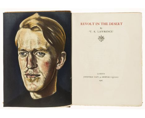
Lot 171
Lawrence (T.E.) Revolt in the Desert, first limited large paper edition numbered 278 of 315, portrait frontispiece and 18 plates, folding map at end, bookplates of Alingham and Robert Lorimer, original morocco-backed boards, lightly faded spine, slight bumping to corners and extremities, 8vo, 1927.⁂ This was produced as an abridgment of 'Seven Pillars of Wisdom' following Lawrence's near bankruptcy over the production of the subscriber's edition.

Lot 174
Egypt.- Dun (Major T. I.) From Cairo to Siwa: Across the Libyan Desert with Armoured Cars, one of 175 copies, signed presentation inscription from the author to title, photographic illustrations, 1 full-page illustration printed in gold, 1 mounted plate printed in silver and another in gold (both rather oxidised), folding map, and a coloured plan of Cairo, text printed in red and black, numerous marginal woodcut illustrations in a variety of colours, decorative gold endpapers, lacking scarab bookmark, original vellum-backed boards, rubbed, 4to, [1933].

Lot 183
NO RESERVE Voyages.- Cailliaud (Frederic) Travels in the Oasis of Thebes, and in the Deserts of the Thebaid, edited by M. Jomard, engraved frontispiece map of the Oasis at Thebes and 17 plates (1 folding), title slightly offset, 1822 bound with Silliman (Benjamin) A Tour to Quebec in the Autumn of 1819, 2 aquatint plates, 1822 bound with 4 other pamphlets, frontispiece and general title loose, foxed and browned, contemporary half calf, worn, upper cover detached, forming vol. VII New Voyages and Travels... Printed for Sir Richard Phillips & Co., 8vo.
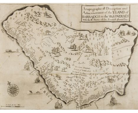
Lot 184
West Indies.- Ligon (Richard) A True & Exact History of the Island of Barbadoes, second edition, folding engraved map with neatly repaired tear, 6 plates of natural history and 3 folding plates concerning sugar processing with the accompanying letterpress explanatory leaf (sometimes bound at end but bound here as directed), title verso with light discolouration from removal of bookplate, but an unusually bright and clean copy otherwise, later calf, gilt, upper joint cracked but holding, light rubbing to spine, [Goldsmiths' 2039; Sabin 41058; Wing L2076], folio, by Peter Parker...and Thomas Guy, 1673.⁂ An early account of Barbados with the first separate map of the island. It also includes much on cocoa, cucumbers and pomegranates, as well as illustrations of bananas and pineapples.
Lot 90
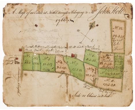
Yorkshire Estate map.- Ableson (William, surveyor, of Hutton Rudby, Stokesley, North Yorkshire) A Survey & Map of an Estate at North Ottrington taken for Mr. John Holt, manuscript title and one page, manuscript double-page estate map, watercolour wash map in green and pink, on paper, small tear in all margins, some foxing, original wrappers, folds, ink stains, 8vo, 1766.

Lot 3128
Guide Books Loftie, W.J. Orient Line Guide. Sampson Low, 1888. 8vo, org. cloth; half-title after Kate Greenaway, tinted plates, maps and plans. Third ed. Le Couteur, Wilson The Great Outposts of the Empire. Federal-Houldershire Lines, 1907. 8vo, org. cloth; b/w photos and map to text. Booth Line Holiday Tours in Spain, Portugal and Madeira. Booth Steamship Company, 1913. 8vo, org. decorative cloth; 6 coloured folding maps and other b/w maps, colour plates and b/w photos to text. Sixth ed. Compania Trasatlantica. Libro de Inormacion. Barcelona, 1921. Oblong 8vo, cloth boards richly decorated in gilt; numerous b/w photos and adverts. With the same 1919, blue cloth with central onlaid vignette. [5]

Lot 3141
British Shipping Paperwork including examples from Campbells, Red Funnel, Stephenson Clarke, Townsend, Cory Fleet, Ian Allan Round the Southern Fleet, The White Funnel Handbook, Souvenir Magazine of the Eagle & Queen Line, Cabin plans Jamaica Settler, The Anzio 1 disaster; Brocklebank Map of India and Pakistan, Map of greater Bombay city, SS Sibun London to West Indies Feb 1895, three Discharge Certificates, Manchester Ship Canal five maps 1894, SS Rameses Breakfast and Luncheon menus (Launched 1893, torpedoed 1918), P A Campbell White Funnel Fleet Extract Murrays Guide and others (qty)
Lot 129
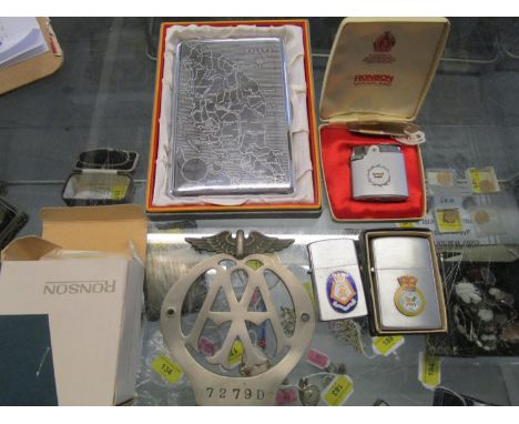
A group of cigarette lighters with Royal Navy associations, to include a Deancut lighter with enamel badge for HMS Andrew submarine, a Penguin light with enamel badge for HMS Amphion with engraving to verso, a boxed Ronson lighter, a cigarette case with engraved map of Malaya and an AA car badge


Lot 366
THE ORB - LP/12" COLLECTION. Dope collection of 5 x LPs and 7 x 12" from The Orb. Titles are U.F.Orb (BLRLP 18 limited edition double LP with art prints housed with black PVC sleeve - top Ex+ copy), The Orb's Adventures Beyond The Ultraworld (BLRDLP 5 original 'Special Classic Pressing', Ex copy w/printed inners), Orbus Terrarum (limited edition 1995 'map pack' double LP - Ex/Ex+), Orblivion (ILPSD 8055, double 1997 LP), Aubrey Mixes (BLR LP14), Assassin, Asylum, Orb In Dub, A Huge Ever Growing Brain..., Perpetual Dawn, Little Fluffy Clouds (promo, ORB PROMO 2) and A Huge Ever Growing Remix (promo, ORB PROMO 1). Condition is typically Ex to Ex+.


Lot 1225
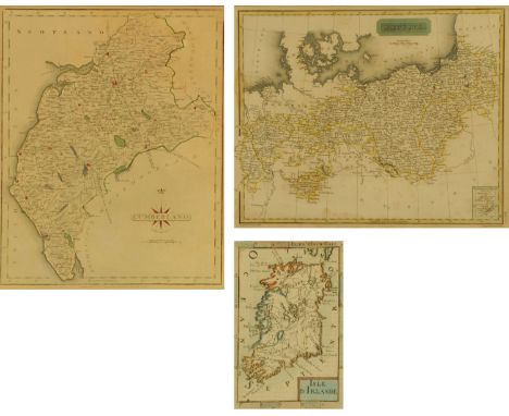
A 17th century map of Ireland, attributed to A M Mallet (1630-1706), "Isle D Irland", hand tinted. 15.5 cm x 10 cm, a John Cary hand tinted engraved map of Cumberland, originally published 1793. 26 cm x 21 cm and a hand tinted engraved map of Prussia, engraved by Sidney Hall, published 1817 by Constable and Co Edinburgh, 21.5 cm x 27 cm.


Lot 1306
John Cary; Suffolk, a hand coloured engraved map, published 1787 by J Carey, 22 x 27cm, together with five other maps to include: Cheshire by Robert Morden, 17 c 22cm; Wiltshire by Herman Moll, 32 x 19cm; Devonshire by John Cowley, 13 x 18cm; Kent by W Palmer, 21 x 25cm and Essex by J Roper after G Cole, 19 x 22cm (6).

Lot 1309
PARROT (Dr Fredrich) Journey to Ararat, with map and woodcuts, n.d., full gilt calf, by Hughes & Kemp Oxford, inscribed '......on his leaving Eton 1865 Election', ST JOHN (J A) Egypt and Nubia, n.d., similarly bound, inscribed '.... on his leaving Eton July 1865', and BUCKLER (George) Twenty-Two of the Churches of Essex, 1856, illustrated, inscribed '.... on his leaving Eton Election 1874', full gilt calf, all with marbled end papers and edges (3).

Lot 182
Six sewing companions comprising an olive wood sewing 'basket' inlaid with thimble and other tools 21.5cm, a red velvet case with five tools and thimble, 17cm, a hussif, 13cm, a red cardboard sewing box with contents, 16.5cm, a book form leather ' Lady's Companion', 9.5cm and a plated metal 'cigarette case' with map of British Isles fitted as a sewing companion (6)
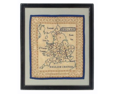

Lot 326
Three samplers, comprising 'The Apostles Creed, SW 1893', worked in coloured wools within a formal border, another 'Elizabeth June 2nd 1953' pictorial centred by map, 43 x 29cm, and another 'Barbara Cartlet Worked This in The 10th Year of Her Age 1823', worked with alphabets and numerals over figures, trees and other motifs, 33 x 23cm, all glazed and framed. (3) (3)

Lot 736
GREEN. WILLIAM, The Tourists New Guide, containing a description of the lakes, mountains and scenery in Cumberland, Westmorland and Lancashire, 2 volumes (1819). CONDITION REPORT: The two volumes have neither the map nor the aquatints present and have both been rebound, however the internal pages are extremely clean. The outer spines are both worn but are intact and the boards are present without any significant damage.

Lot 824
A collection of 23 Lake District books, to include Priors Ascents & Passes in The Lake District (1865) complete with pullout map, the History & Antiquities of Allerdale Ward Above Derwent by Samuel Jefferson, illustrated with numerous plates and engravings (1842), Tales & Legends of The Lake District by Armistead, Walking in The Lakes by Symonds, etc.


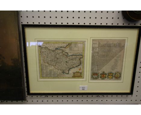


Lot 446
Robert Morden (1668-1703) - Coloured engraving - Map of "Midlesex", published by Abel Swale and John Churchill, 16.75ins x 14.25ins, and two coloured engravings - "A Map of the County of Hertford", by C & J Greenwood, 30ins x 24ins, and Jacques-Nicolas Bellin (1703-1772) -"Carte de L'Isle de Sainte Lucie", map of St Lucia, 12.5ins x 8.5ins, all framed and glazed

Lot 154
A Collection of Curios to Include a 19th Century Bone Handled Corkscrew (AF), A Vintage Wooden Handled Penknife and an American Sterling Silver Souvenir Spoon with Native American Decoration to Handle and Bowl Inscribed with State Capitol, Denver Gold Treble Leather Cased Tape Measure no.1533, a Late 19th Century Souvenir Glass Paperweight, A Map Measure, Ship in a Bottle, Vintage Postcard 'William Ball - The Shropshire Giant', Yarmouth Vesta Case, Resin Novelty Study of Seated Queen Victoria etc

Lot 1258
A BOX OF ASSORTED BOOKS to include 'English Inn Signs' by Jacob Larwood, 'The Beauties of Sterne' printed 1782, 'Pattersons English Itinerary', 'Picture of London' 27th edition, 'Shepherds International Directory of Print and Map Sellers', 'The Great North Road' by Norman Webster, together with a variety of other books


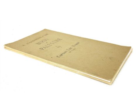
Lot 209
HARDY, Captain Eric (R. Signal Secretary, Jerusalem Naturalists’ Club), A Handlist of the birds of Palestine. Printed in the office of the Education Officer-in-Chief, G. H. Q, Middle East Forces [1946], First and only edition; 4to. (typewritten), PP: (iv), 1-47, (ii)Bibliography, + line Map of North and Central Palestine. Loose in paper wrappers, as issued. (Scarce)

Lot 224
JOHNS, W. E: 6 GIBLET First Editions all with Dust Jackets (1947-52); All in Exceptionally Good condition , some of the dws little frayed & with small tears : Giblet mops up; Giblet’s Oriental quest; Giblet lends a hand; Giblet bores in; Giblet off the map; Giblet gets the answer; Plus early reprints with dws of: Giblet goes again; Giblet comes home; & Giblet king of the commandos. (9)
Lot 233
CHAPMAN, John & Peter ANDRE: A map of the county of Essex, From an Actual Survey made in MDCCLXXII, MDCCLXXIII & MDCCLXXIV. London: 1st October 1777, first edition. Folio (55 x 40 Cms.). With 25 double-page engraved sheets , including title, list of subscribers and index map, all hand-coloured. 216 subscribers, some ordering more than one copy, making a total of 240 copies . Contemporary full leather, rebacked preserving the original spine. Index map and a couple of others creased at the fold; most folds strengthened when the copy was recased; light offsetting to a couple of the maps. NOTE: The index map is divided into 25 section, including the list of subscribers (XX) and title page (XXV). The maps run from number I to number XIX and XXI to XXIV; Number XX is the list of subscribers, and number XXV is the title page.

Lot 235
ATLAS: 1- Fisher's County Atlas of England and Wales. Compiled from authentic surveys, and corrected to the present time. With a topographical and statistical description of each county. Fisher, Son, no date, (1847). Folio, with 48 coloured Maps, including one large folding and two double page. Original cloth, gilt leather label to upper cover and later cloth spine and new endpapers. The folding general map laid down on card. VG ; 2- Butler, S: An Atlas of ancient Geography. Longman.., no date, C1840. With 22 double-Page maps (21 hand-coloured in outline). Later half leather over original marbled boards and new endpapers. Ink stains to top margin of one map ; 3- Dower, J: Short Atlas of Modern Geography. With only 10 out of the 12 hand coloured double page maps, lacking: British Isles and Asia (3)
-
109198 item(s)/page