![[MISCELLANEOUS] Scott, Sir Walter. The Lady of the Lake, Ross, Edinburgh, 1871, Lorne tartan-ware covers with a dark green l](https://cdn.globalauctionplatform.com/f35a251d-82bc-4a41-8b35-a8c5011791a0/3661aba7-8e3b-4d64-9887-30e0cb54a3a3/468x382.jpg)

Lot 712
[MISCELLANEOUS] Scott, Sir Walter. The Lady of the Lake, Ross, Edinburgh, 1871, Lorne tartan-ware covers with a dark green leather gilt spine, all edges gilt, frontispiece and a further eight mounted photographic illustrations, octavo; Black's Picturesque Guide through North and South Wales, twelfth edition, Black / Catherall & Prichard, Edinburgh / Chester, 1863, original green cloth gilt, map endpapers, plate and text illustrations, two folding railway maps, folding map of Wales, thirty-six page advertiser, further advertisement leaf, octavo; and two other works, (4).
![[MAPS] Morden, Robert (c.1650-1703), 'Oxfordshire', engraved county map, hand-coloured in outline, sold by Abel Swale Awnsha](https://cdn.globalauctionplatform.com/f35a251d-82bc-4a41-8b35-a8c5011791a0/8ac3dd8e-d76e-461c-f4c7-4391c10a5fa0/468x382.jpg)
![[MAPS] Speed, John (1552-1629) & Hondius, Jodocus (1563-1612), 'The Countie of Radnor', engraved county map, hand-coloured i](https://cdn.globalauctionplatform.com/f35a251d-82bc-4a41-8b35-a8c5011791a0/3425dceb-3967-4415-9f28-144483a98337/468x382.jpg)
![[MAPS] Moll, Hermann (c.1654-1732), 'The North Part of Great Britain called Scotland', engraved map, hand-coloured in outlin](https://cdn.globalauctionplatform.com/f35a251d-82bc-4a41-8b35-a8c5011791a0/066aaa65-3344-48c5-ca6c-a7e52495ef08/468x382.jpg)
![[MAPS]. WALES Bacon's New Tourist Map of North Wales, folding, hand-coloured in outline, 48.5cm x 48.5cm, green cloth covers](https://cdn.globalauctionplatform.com/f35a251d-82bc-4a41-8b35-a8c5011791a0/aaf94bc0-b1d0-4133-aee8-363cf8396867/468x382.jpg)


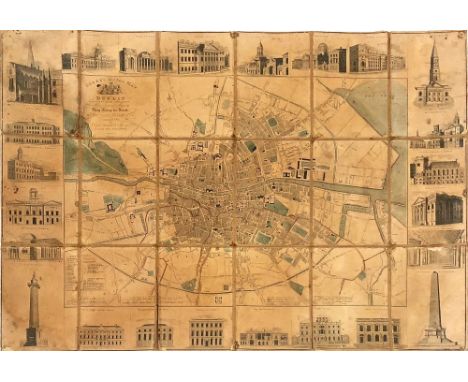
![Irish Map: Dublin, [Rocque (John)] A Plan of the City and Suburbs of Dublin by J. Rocque Reduced from his large Plan, engrave](https://cdn.globalauctionplatform.com/9a031618-5f56-4e03-b082-a8af00ef4ace/00464368-ef15-4210-d432-2731ef43d4bb/468x382.jpg)


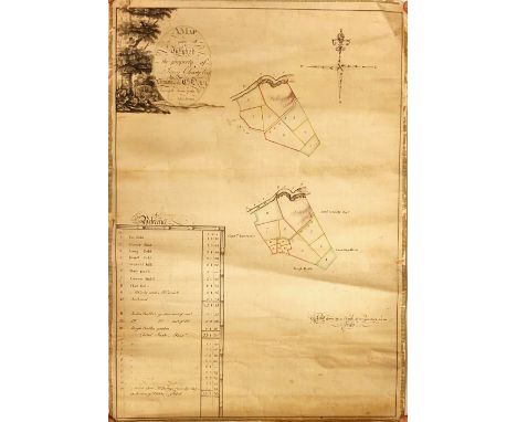
![Co. Offaly: Bogs in Ireland: Longfield (Jno) A Map of Eleven Divisions of District Number - Five [Co. Offaly], of Bogs of Ire](https://cdn.globalauctionplatform.com/9a031618-5f56-4e03-b082-a8af00ef4ace/46bee315-5469-454a-a9f2-623ff087a119/468x382.jpg)


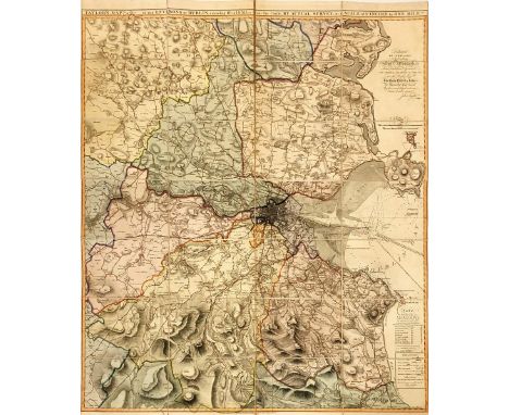
![Map: Switzerland: [Visscher (N.) & Schneck (P.)et al, Cart.] Scheuchzer (Johann (Jakos)pub. Nova Helvetia Tabula Geographica](https://cdn.globalauctionplatform.com/9a031618-5f56-4e03-b082-a8af00ef4ace/85f2fc5e-8f55-4c6b-c6a3-c283f2f7915e/468x382.jpg)


![[Walford (Thos.)] The Scientific Tourist through Ireland, 12mo L. 1818. First Edn., Engd. frontis & add. engd. title, fold. m](https://cdn.globalauctionplatform.com/9a031618-5f56-4e03-b082-a8af00ef4ace/bb44798c-4fc5-47d5-d11f-aed9c099ea72/468x382.jpg)


![Co. Derry: Colby (Col. Thos.) Ordnance Survey of the County of Londonderry, Part I [All Published] D. 1837, First Edn., hd. c](https://cdn.globalauctionplatform.com/9a031618-5f56-4e03-b082-a8af00ef4ace/74090599-42b0-4986-d97c-9fa816bd7bd1/468x382.jpg)


