We found 109182 price guide item(s) matching your search
There are 109182 lots that match your search criteria. Subscribe now to get instant access to the full price guide service.
Click here to subscribe- List
- Grid
-
109182 item(s)/page


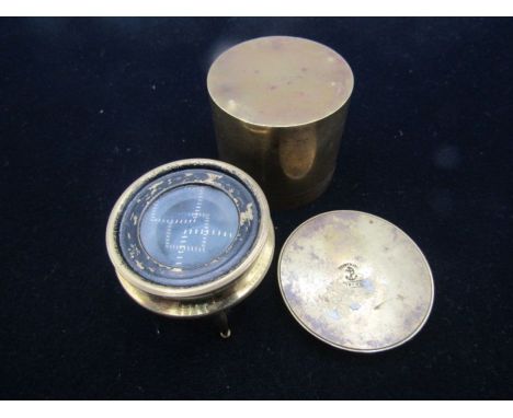
Lot 1012
The Tourist's Guide through the County of Kent, and Part of Sussex; Describing the Principal Watering Places, and Most Interesting Objects. Embellished with Twelve Copper Plate Views, and a Correct Map of the County, and Containing a Water Itinerary from London to Margate, London, Wallis, early 19th Century, 116 pp, gilt-tooled half calf with comb marbled boards, 14 cm x 9 cm


Lot 33
SOL LEWITT (1928-2007)R706 Map of London with the area between the underground stations at Marble Arch, St. James Park, Leicester Square, Waterloo Station, Pimlico, Sloane Sq., Knightsbridge, Bayswater, Edgeware Road and Bond St., removed 1977 signed, titled and dated 1977cut paper map57.2 by 88.7 cm. 22 1/2 by 34 15/16 in.Footnotes:ProvenanceLisson Gallery, LondonAcquired directly from the above by the present owner in 1978LiteraturePeter Schjeldahl, Art of our Time: The Saatchi Collection 1, London 1984, n.p., no. 47, illustrated in colourFor further information on this lot please visit Bonhams.com


Lot 349
AN ASSORTMENT OF MILITARIAincluding a Sam Browne belt, brace and sword frog, bayonet frogs, sword-slings and knots, an OR~s 1902 webbing belt, a buff pouch belt rifle-slings, spurs, buttons etc, together with a large khaki canvas map-case and a green tin containing a Foot Guards RSM~s unissued rank badge in gold and silver embroidery, and a Sergeant~s gold-lace chevron, both on scarlet cloth, and approximately 15 brass and 3 white metal chin chains for Full Dress headdress(qty)Provenance; David Jeffcoat (1945 - 2020);
Lot 311
A selection of pictures to include a oval watercolour portrait of a Victorian lady in a white bonnet, embossed mounting and glazed gilt frame, various woodcuts and prints to include those by Norman Kent, George Reiss, William Russell Flint, and others, along with a boxed King Henry's map of the British Isles reproduced from a map in the British Library by Beacon Press for the Folio Society, Ltd edition to 2750 copiesLocation:


Lot 587
The Royal Geographical Society Patron’s Gold Medal awarded to Captain Sir Alexander R. Glen, K.B.E., D.S.C., Royal Naval Volunteer Reserve Royal Geographical Society, Patron’s Gold Medal, 54mm, gold (9ct, 95.24g), the obverse featuring the bare head of George VI facing left, the reverse featuring Minerva standing left, holding wreath and map, with globe and sextant on ground, ‘Ob Terras Reclusas’ above, the edge engraved ‘Lieutenant Alexander R. Glen, R.N.V.R., 1940.’; together with the recipient’s Exploration of Polar Regions Bruce Medal for Valuable Services, 50mm, bronze, the edge engraved ‘Alexander Glen 1938’, nearly extremely fine (2) £6,000-£8,000 --- Sir Alexander (Sandy) Richard Glen was born in Glasgow on 18 April 1912, the son of a Glasgow ship-owner, and was educated at Fettes College, Edinburgh, and Balliol College, Oxford, where he read Geography. He first travelled to the Arctic in 1932, as part of an eight man crew of a 45ft fishing boat owned by a Cambridge law don; legend has it that Glen accepted the invitation to accompany the expedition under the misapprehension that it was an invitation to a debutante ball. Setting sail from King’s Lynn (with Glen still in his white tie and tails), the crew ventured to Spitzbergen, and completed 4,000 miles of sailing and two months of surveying. The following year Glen led a more official 16 man Oxford University summer expedition to Spitzbergen to carry out topographical and geological surveys, spending some winter months with the Lapps of northern Sweden. He returned to Spitzbergen the following summer with the author Evelyn Waugh amongst the team (who nearly drowned when a glacier thawed). In 1935 he led another Oxford University expedition, establishing a research station on the ice cap of North East Land, and carried our research in glaciology, geology, and radio propagation in high latitudes. In 1937 he wrote a book about the expedition, entitled ‘Under the Pole Star’. For his expeditions and scientific work in the Arctic Glen was awarded the prestigious Patron's Gold Medal of the Royal Geographical Society in 1940; at the age of 28 he was (and is) the youngest recipient of the medal. He was also awarded the Polar Medal (London Gazette 10 February 1942: ‘For good services with the Oxford University Arctic Expedition to North East Land in 1935 and 1936’) and received the Bruce Medal of the Royal Society of Edinburgh in 1938. After going down from Oxford Glen worked in investment banking in New York and London. He joined the Royal Naval Volunteer Reserve in 1938, and posted to Naval Intelligence he worked with Ian Fleming under its Director, Admiral John Godfrey. Inevitably, in later life it was rumoured that Glen was perhaps an inspiration for James Bond, but Glen himself always denied the link: ‘I don’t think it is true for a moment; I’m far too gentle, too law-abiding.’ In January 1940 Glen was posted to Belgrade as assistant naval attaché at the British legation, where he met his future wife, the Serbian Baroness Zora (Zorica) de Collaert. Following the bombing of Belgrade in 1941 the British legation left and made their way home via Kotor, Albania, Italy, Vichy France, and Spain. He then worked on the staff of Rear-Admiral Philip Vian in 1941 helping to evacuate Norwegian and Russian coalminers and trappers in the Arctic Circle, and he spent some time protecting Spitzbergen from a German invasion. In the early summer of 1942, he took part in two 27-hour reconnaissances of Spitzbergen by Catalina flying boats of Coastal Command, based in the Shetlands. He then joined a 70-strong joint British-Norwegian force sent by boat, which was sunk by a Luftwaffe raid as they arrived in Spitzbergen harbour. As the survivors struggled ashore, Glen remembered where to find the frozen corpses of 60 slaughtered pigs, and they lived off these, washed down with abandoned German brandy and champagne. Glen later served with distinction with the Russian Army in eastern Europe in 1943-44, sabotaging traffic on the River Danube to disrupt oil supplies to Germany. He also took part in various clandestine and dangerous operations in Yugoslavia with Fitzroy Mclean, in support of Marshal Tito. He ended the War on the British staff in Athens. For his services during the Second World War he was awarded the Distinguished Service Cross in 1942 (London Gazette 27 October 1942), and a Second Award Bar in 1945 (London Gazette 20 February 1945). He was also awarded the Norwegian and Czechoslovakian War Crosses, and was created a Chevalier First Class of the Order of St. Olav (London Gazette 9 May 1944). Post-War, Glen joined the ship-broking business of Clarksons, eventually rising to become the firm’s Chairman. Remaining in the Royal Naval Volunteer Reserve, he was advanced Captain in the Supply and Secretariat Branch on 30 June 1955, and served as a Member of the Council of the Royal Geographical Society periodically from 1945 to 1962. Appointed C.B.E. in 1964 (London Gazette 1 January 1964), he was advanced K.B.E. in 1967 (London Gazette 1 January 1967), and went on to hold various positions in the travel and hotel sector, including the Chairmanship of the British Tourist Authority. Amongst other public appointments he became Chairman of the Advisory Council of the Victoria and Albert Museum. He published his memoirs ‘Footholds Against a Whirlwind’, in 1975, and co-wrote (with Leighton Bowen) ‘Target Danube, a River not quite too far’ in 2002. He died on 6 March 2004. The Sandy and Zorica Glen Charitable Settlement (Charity no. 326311) is a grant making charity that supports a small range of charities in helping to develop leadership qualities in the young via exploration trips and other outdoor activities; and encouraging the conservation of heritage works of art. For the recipient’s group of twelve miniature awards, see Lot 618.

Lot 74
A good Second War 1945 ‘Kyaukse operations’ M.C. group of six awarded to Major D. G. Butterworth, 9th Battalion, 12th Frontier Force Regiment, who was about to lead his Company in an attack on a heavily defended position, when he received a signal informing him that he would have to assume command of the Battalion due to the O.C. and all other officers at Battalion H.Q. being wounded by a Japanese sniper’s grenade. He remained with his company long enough to see them on their way, and then hastened to Battalion H.Q. from where he restored order and proceeded to successfully orchestrate the Battalion’s attack. Butterworth was ‘able to secure all his objectives and force some two hundred Japanese to break and flee’ Military Cross, G.VI.R. reverse officially dated ‘1945’; India General Service 1936-39, 1 clasp, North West Frontier 1937-39 (Lt. D. G. Butterworth, 1-12 F.F.R.); 1939-45 Star; Burma Star; War Medal 1939-45, with M.I.D. oak leaf; India Service Medal, mounted for display, generally very fine or better (6) £1,600-£2,000 --- M.C. London Gazette 20 September 1945. The original recommendation states: ‘For highly distinguished services and gallantry in action - at Sigon in Burma on 26 March 1945 during operations to clear a strong force of enemy who were threatening the main road to Kyaukse and jeopardising the operations of the leading Battalions against Kyaukse. Major Butterworth was commanding his company which was to assault the first located enemy position. Just before H hour he received a signal that he would have to assume command of the Battalion, 9th Battalion, 12th Frontier Force Regiment, as the Commanding Officer and all other officers at Battalion Headquarters had been wounded and evacuated. He remained with his company long enough to see them leave their start line and on arriving at Battalion Headquarters he found great confusion. Heavy grenade discharger and small arms fire was coming into Battalion Headquarters. As he arrived he heard his company had been pinned to the ground by accurate MMG fire just in front of theur start line, and were taking heavy casualties, amongst whom was the officer who had taken over command from him. He then showed leadership of the highest standard and quickly ordering another company to move round the flank of the enemy holding up the leading company and arranging for his heavy artillery in support of him to destroy by bombard the enemy bunkers which had brought the attack to a standstill, he was able to secure all his objectives and force some two hundred Japanese to break and flee. The leadership displayed by this officer under extremely difficult conditions, together with his gallantry under fire were a fine inspiration both to Battalion Headquarters who in confusion when he arrived and his company who were having a hard fight. Such was his inspiration to his Battalion, that notwithstanding the loss of their Commanding Officer, Adjutant, and Intelligence officer, they were inspired to fight to a successful finish their battle and completely put to rout the enemy who had control of the main road to Kyaukse.’ M.I.D. London Gazette 5 April 1945. Derrick Geoffrey Butterworth was born in Belgaum, India in November 1913. He was commissioned Second Lieutenant in the 12th Frontier Force Regiment in February 1934, and advanced to Captain in October 1940. Butterworth served with the 9th Battalion during the Second War, and Officer Commanding, Administrative Company when the Battalion entered the Burma theatre in October 1943. Initially stationed in the Kabaw Valley, the Battalion command was restructured and in June the following year, Butterworth was Second-in-Command and in Command of the H.Q. Company. Early in the new year, Butterworth was in command of ‘A’ Company and by now heavily involved in the reconquest of Burma. The Regimental History gives the following: ‘The Battalion was now ordered to capture Yezin and Inza, clearing all Japs from the area between Kanlan Ywathit and Kanlan. This operation was ordered for 28th February and proved to be the Battalion’s outstanding achievement in the campaign for the reconquest of Burma. A tank squadron of the 7th Cavalry and the divisional artillery supported the attack. ‘C’ Company with the tanks led the advance, with ‘B’ Company following, and immediately found difficulty in locating the Japs who were well dug in and concealed in elephant grass and tobacco fields. Hand-to-hand fighting ensued, slowing down the advance. Major Butterworth wrote of this stage of the action as follows: “A Jemadar of ‘D’ Company had a hand-to-hand fight with a Jap officer and killed him in full view from Battalion Headquarters at Kanlan. A lot of slaughter was done to the east of Yezin in the nullah, by the tanks and ‘C’ Company, who stuck to the tanks like leeches. The Japs had anti-tank mines with them which they were clutching to themselves, attempting to blow the tanks up and themselves at the same time. A 105mm gun crew fought to the end until they were wiped out by the tanks. They were firing point blank over the sights.” As ‘C’ Company advanced with the tanks, enemy artillery and MMG fire caused casualties, and ‘B’ Company also became involved in the mêlée in the area south of Kanlan, where the main force of Japs was found to be dug in with strong bunkers, difficult for the tanks to deal with. However, the advance was not held up.’ Butterworth distinguished himself during the operations around Kyaukse (see recommendation above), and the Regimental History gives the following: ‘As a preliminary to the main attack on Kyaukse, the Battalion cleared the outlying villages of Thimbok and Kegwigye, and in this action Lieutenant Waters was killed. He was a keen young officer who had only recently joined the Battalion. The Commanding Officer, Lieutenant Colonel Hayaud Din, also was wounded at Kyaukse. He gives the following account of the action: “Actually the attack had gone off very well. The village had largely been cleared, and the Japs were running away fast. The forward companies were going well with Battalion Headquarters behind them. I stopped with the Adjutant, Captain Miller, and the Intelligence Officer, Lieutenant Bangash, to look at a map, when a Jap sniper hiding in a bush and not far from us popped up and threw a grenade at us. This landed in the middle of our group, wounding all three of us. However, I was able to continue commanding the Battalion, but sent off Miller and Bangash to the aid post for treatment. Later when the medical Officer learnt that I had also been wounded he came forward. As I was still bleeding he insisted on taking me back, and I sent for Butterworth to take over command.” Major Butterworth also writes: “We had a bit of trouble next day, but the Japs were clearing out every night. The Battalion was the first to enter Kyaukse. Some of us got up to Maymo from there, where we got news of the excellent work done there in the Jap hospital by our first Medical Officer Lieutenant Batt. He had earlier been captured on the first day the Japs came over the Chindwin advancing on Imphal.”’ The Battalion was given a further complete rest at Kyaukse, and in view of the heavy casualties it had suffered, particularly among officers, its role was now changed to Divisional Headquarters Battalion. Butterworth was posted to the Staff College at Quetta in June 1945, and appointed Brigade Major, Frontier Brigade Group the following year. Major Butterworth retired in 1947, and in later life resided at The Green Farm, Wangford, Beccles, Suffolk. He died...


Lot 270
British Isles, De Wit, Frederick, Nova totius Angliae, Scotiae et Hiberniae,DE WIT, FREDERICK, cartouch reads ‘Nova totius Angliae, Scotiae et Hiberniae’, printed Amsterdam, c.1680, hand-coloured, double-page, engraved map, decorative cartouches and coats-of-arms, untrimmed page with original edges, tear to bottom left corner.
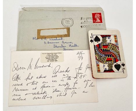
Lot 394
WW2 RAF Escape and Evasion Playing Card Map with Provence. An extremely rare original Jack of Spades Playing card, the rear peels back to reveal a part map of Germany, formally belonging to Air Marshal Sir Charles Edward Chilton, KBE, CB. The plying card is accompanied by a had written card from the Air Marshal stating that this is his last card from a set which converts to a map of Germany. The letter card is dated 25th November 1979 and complete with the original envelope post stamp 27 November 1979. Air Marshal Sir Charles Edward Chilton, KBE, CB was commissioned into the RAF 1924 specialising as a Navigator. In 1943 he was Commanding RAF Chivenor and retired in 1962 having been Air Officer Commanding Coastal Command. He died in 1992.

Lot 188
Burlington (Charles), Rees (David Llewellyn) & Murray (Alexander), THE MODERN UNIVERSAL BRITISH TRAVELLER; Or, A New, Complete, and Accurate Tour Through England, Wales, Scotland And The Neighbouring Islands. Comprising All that is Worthy of Observation in Great Britain. And Containing a Full, Ample, and Circumstatial Account of Every Thing Remarkable in the Several Cities, Boroughs, Market Towns, Villages, Hamlets, &c., Throughout the Kingdom, full leather, laid paper, foldout frontispiece Map Of Great Britain by Thomas Bowen, inscription dated 1887 to front free endpaper, engraved pictorial frontispiece, foldout map of the roads of England and Wales, engraved plates throughout, printed for J. Cooke, London circa 1780 (at fault)
![Blome (Richard), [BRITANNIA] BRITANIA: OR A GEOGRAPHICAL DESCRIPTION OF THE KINGDOMS OF ENGLAND, SCOTLAND, AND IRELAND, WITH](https://cdn.globalauctionplatform.com/909dc926-9be4-4786-9b0d-aeb30096f227/5a3a743c-1625-4a75-9a78-aeb501033e20/468x382.jpg)
Lot 192
Blome (Richard), [BRITANNIA] BRITANIA: OR A GEOGRAPHICAL DESCRIPTION OF THE KINGDOMS OF ENGLAND, SCOTLAND, AND IRELAND, WITH THE ISLES AND TERRITORIES THERETO BELONGING, full leather, red title label and gilt embossed decoration to spine, laid paper, monochrome title page with single "N" spelling of Britannia, dedication to Charles II, twenty three pages (thirteen leaves) of engraved coats of arms of benefactors and promoters (some hand coloured, the last three leaves possibly later added), fold out maps of the British Isles, North Wales (one beginning the "Wales" section, the other beginning the "North Wales" section), South Wales, Scotland and Ireland, forty four double page county (and part county) maps (some hand coloured and some on different paper - possibly later additions), a single page map of the Thames through Westminster and Southwark, and "An Alphabetical Account Of The Nobility And Gentry, Which Are (Or Lately Were) Related Unto The Several Counties Of England And Wales", printed by Thomas Roycroft for the Undertaker, Richard Blome, London 1673 (at fault)

Lot 205
Martin (R. Montgomery) (Ed), TALLIS'S ILLUSTRATED ATLAS, AND MODERN HISTORY OF THE WORLD, GEOGRAPHICAL, POLITICAL, COMMERCIAL AND STATISTICAL, folio (37.3cm x 28cm), 3/4 leather, green cloth boards, buff endpapers (possibly later), engraved Great Exhibition frontispiece, illustrated half title page, letter-press title page, "Directions To The Binder" page, two "Waterfall, Islands..." comparison plates, eighty one map plates after J. Rapkin with hand coloured outlines and borders (complete as per binder's directions), John Tallis And Company, London 1851 (at fault)

Lot 206
Martin (R. Montgomery) (Ed), TALLIS'S ILLUSTRATED ATLAS, AND MODERN HISTORY OF THE WORLD, GEOGRAPHICAL, POLITICAL, COMMERCIAL AND STATISTICAL, folio (38cm x 28.3cm), 3/4 leather, marbled boards, buff endpapers, inscription to front free endpaper, engraved double page Liverpool street plan frontispiece, tissue guarded illustrated title page, two "Waterfall, Islands..." comparison plates, seventy nine hand numbered map plates after J. Rapkin with hand coloured outlines and borders (eighty are listed in the index - number 27 "Gibraltar, Malta, And The Ionian Isles" does not appear to have been bound in), John Tallis And Company, London circa 1851 (inscribed for 1854) (at fault)

Lot 209
PIGOT & CO'S BRITISH ATLAS, COMPRISING THE COUNTIES OF ENGLAND, (UPON WHICH ARE LAID DOWN ALL RAILWAYS COMPLETED AND IN PROGRESS), WITH SEPARATE LARGE SHEET MAPS OF ENGLAND AND WALES, IRELAND AND SCOTLAND, AND A CIRCULAR ONE OF THE COUNTRY ROUND LONDON, folio (41.2cm x 30.5cm), later half green leather with green cloth boards, illustrated title page, double page reciprocal distance table, all maps present as per contents page: three folding engraved maps of England & Wales, Scotland and Ireland, thirty-nine engraved maps including one folding (Yorkshire) and a circular folding map of London, all with contemporary hand colouring, J. Pigot & Co, London circa 1840 (at fault)
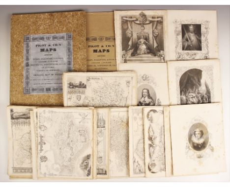
Lot 213
PIGOT & CO.'S MAPS OF THE COUNTIES OF DERBY, HEREFORD, LINCOLN, LEICESTER AND RUTLAND, MONMOUTH, NOTTINGHAM, SALOP, STAFFORD, WARWICK AND WORCESTER; WITH A GENERAL MAP OF WALES, BEING AN APPENDAGE TO THE MIDLAND AND COUNTY VOLUME OF THEIR NATIONAL AND COMMERCIAL DIRECTORIES, stitched paper wrappers with printed publisher's title block, large folding map of Wales and ten engraved county maps, all with contemporary outline colouring, contained in later marbled slip case, Pigot & Co, circa 1828, with a quantity of loose prints taken from various publications to include county maps and Royal portraits in a plastic folder (2) (at fault)

Lot 214
ATLAS OF THE COUNTIES OF ENGLAND FROM ACTUAL SURVEYS MADE FROM THE YEARS 1817 TO 1833 BY C. & J. GREENWOOD, large folio (66.5cm x 81cm), 3/4 leather, green cloth boards, gilt embossed decoration to cover and spine, engraved title page with coloured map of England and Wales, forty six further coloured maps engraved by J. & C. Walker, Greenwood & Co, London 1834 (at fault)

Lot 222
Stackhouse (Thomas), THE HISTORY OF THE HOLY BIBLE, FROM THE BEGINNING OF THE WORLD TO THE ESTABLISHMENT OF CHRISTIANITY, 5 books bound as one volume, 3/4 leather, laid paper, lacking frontispiece and title page, opening with a dedication to Edmund, Bishop Of London dated "7 April 1744", followed by "The Apparatus To The History Of The Old Testament" and "The Preface", the five books each with illustrated title page, engraved woodblock plates throughout including map and five foldout plates, lacking publisher's details (at fault)
-
109182 item(s)/page